233:
29:
242:
251:
216:
named after homonymous peak which lies near
Polezhan. Depending on weather conditions the mountain refuge is about 2-3h from Polezhan. Two of the highest lakes in Pirin are situated in the vicinity of Polezhan, namely the
232:
339:Мичев (Michev), Николай (Nikolay); Михайлов (Mihaylov), Цветко (Tsvetko); Вапцаров (Vaptsarov), Иван (Ivan); Кираджиев (Kiradzhiev), Светлин (Svetlin) (1980).
400:
405:
61:
54:
395:
221:
at 2,706 m, the second highest lake in
Bulgaria, as well as the Upper Gazey Lake at 2,642 m.
28:
213:
154:
139:
131:
101:
218:
198:
241:
190:
183:
112:
389:
202:
284:
189:
It is situated on the
Polezhan side ridge which also includes the summits of
76:
63:
206:
285:"Polezhan : Climbing, Hiking & Mountaineering : SummitPost"
163:
105:
347:] (in Bulgarian). София (Sofia): Наука и култура (Nauka i kultura).
306:
304:
170:
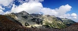
summit in Pirin and the fourth highest in the mountain range after the
167:
179:
175:
171:
44:
250:
378:
361:
194:
159:
119:
310:
209:(2,700 m), as well as the imposing edge of Strazhite.
33:
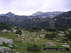
Polezhan peak as viewed from the saddle next to Bezbog peak.
111:
97:
92:
53:
43:
38:
21:
158:) is a 2,851 m cone shaped high peak in the
148:
8:
18:
352:Душков (Dautov), Добри (Nikolay) (2008).
369:Душков (Dushkov), Добри (Dobri) (1972).
271:
264:
228:
322:
311:Geographic Dictionary of Bulgaria 1980
381:): Наука и култура (Nauka i kultura).
364:): Наука и култура (Nauka i kultura).
153:
138:
7:
14:
401:Landforms of Blagoevgrad Province
345:Geographic Dictionary of Bulgaria
249:
240:
231:
27:
212:The closest mountain refuge is
162:mountain range, south-western
1:
377:] (in Bulgarian). София (
360:] (in Bulgarian). София (
341:Географски речник на България
49:2,851 m (9,354 ft)
406:Two-thousanders of Bulgaria
358:Pirin. Dictionary and Guide
422:
371:Пирин. Туристически речник
354:Пирин. Туристически речник
375:Pirin. Tourist Dictionary
149:
135:
26:
155:[maŋˈɡɤrtɛˈpɛ]
166:. It is the highest
143:, known pre-1942 as
219:Upper Polezhan Lake
205:(2,763 m) and
182:(2,908 m) and
73: /
396:Mountains of Pirin
325:, pp. 101–102
289:www.summitpost.org
274:, pp. 129–130
140:[polɛˈʒan]
102:Blagoevgrad Region
39:Highest point
186:(2,884 m).
125:
124:
77:41.717°N 23.483°E
413:
382:
365:
348:
326:
320:
314:
308:
299:
298:
296:
295:
281:
275:
269:
253:
244:
235:
201:(2,645 m),
197:(2,761 m),
193:(2,822 m),
178:(2,914 m),
157:
152:
151:
142:
137:
115:
88:
87:
85:
84:
83:
78:
74:
71:
70:
69:
66:
31:
19:
16:Peak in Bulgaria
421:
420:
416:
415:
414:
412:
411:
410:
386:
385:
368:
351:
338:
335:
330:
329:
321:
317:
309:
302:
293:
291:
283:
282:
278:
270:
266:
261:
254:
245:
236:
227:
113:
81:
79:
75:
72:
67:
64:
62:
60:
59:
34:
17:
12:
11:
5:
419:
417:
409:
408:
403:
398:
388:
387:
384:
383:
366:
349:
334:
331:
328:
327:
315:
300:
276:
263:
262:
260:
257:
256:
255:
248:
246:
239:
237:
230:
226:
223:
191:Malak Polezhan
184:Banski Suhodol
123:
122:
117:
109:
108:
99:
95:
94:
90:
89:
82:41.717; 23.483
57:
51:
50:
47:
41:
40:
36:
35:
32:
24:
23:
15:
13:
10:
9:
6:
4:
3:
2:
418:
407:
404:
402:
399:
397:
394:
393:
391:
380:
376:
372:
367:
363:
359:
355:
350:
346:
342:
337:
336:
332:
324:
319:
316:
313:, p. 379
312:
307:
305:
301:
290:
286:
280:
277:
273:
268:
265:
258:
252:
247:
243:
238:
234:
229:
224:
222:
220:
215:
210:
208:
204:
200:
196:
192:
187:
185:
181:
177:
173:
169:
165:
161:
156:
146:
141:
133:
129:
121:
118:
116:
110:
107:
103:
100:
96:
91:
86:
58:
56:
52:
48:
46:
42:
37:
30:
25:
20:
374:
370:
357:
353:
344:
340:
318:
292:. Retrieved
288:
279:
272:Dushkov 1972
267:
211:
188:
144:
127:
126:
114:Parent range
323:Dautov 2008
150:Мангър тепе
145:Mangar Tepe
80: /
55:Coordinates
390:Categories
333:References
294:2021-08-26
203:Kaymakchal
259:Citations
207:Disilitsa
132:Bulgarian
93:Geography
45:Elevation
164:Bulgaria
128:Polezhan
106:Bulgaria
98:Location
22:Polezhan
225:Gallery
168:granite
136:Полежан
68:23°29′E
65:41°43′N
214:Bezbog
199:Bezbog
180:Kutelo
176:Vihren
174:peaks
172:marble
379:Sofia
373:[
362:Sofia
356:[
343:[
195:Gazey
160:Pirin
120:Pirin
392::
303:^
287:.
134::
104:,
297:.
147:(
130:(
Text is available under the Creative Commons Attribution-ShareAlike License. Additional terms may apply.