351:
461:
29:
442:
195:
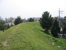
was set up by heaping earth at a slant. On the top of the last earthen layer of the inner wall, pebbles were laid in three layers and trimmed stones were piled up inside 1.5 m high with mud prepared from natural soil, and by piling up the central part in trapezoid shape whose lower part is 7m wide and 5m high.
194:
Only 2.7 km of its walls remain. Including the west wall, which had been destroyed by flooding, its circumference reaches about 3.5 km and its area nearly 859,508 m. After constructing this central part, the inner wall, mainly composed of sandy soil, grit, clayish soil and muddy soil,
243:
251:
183:. It has a long oval shape, spreading to north and south, and leaning slightly toward the east. Based on research conducted during the Japanese occupation, it has been speculated that Pungnap Toseong was Hanam
542:
498:
339:
517:
212:
317:
522:
381:
491:
527:
484:
431:
325:
288:
154:
94:
332:
275:
247:
355:
222:
537:
108:
396:
218:
180:
391:
386:
164:
426:
532:
401:
134:
468:
416:
511:
411:
406:
376:
33:
The remains of earthen ramparts of
Pungnaptoseong (widely believed to be the site of
460:
366:
168:
371:
350:
184:
34:
28:
303:
290:
167:
in Korea. It has a circumference of 3.5 km. It is located in modern-day
172:
99:
84:
81:
78:
75:
72:
280:
188:
48:
441:
176:
144:
64:
321:
467:
This article about a South Korean building or structure is a
113:
472:
179:. It used to be included in the neighboring city of
158:
107:
93:
63:
47:
42:
163:) is a flat earthen wall built at the edge of the
492:
333:
8:
148:
138:
131:Earthen Fortification in Pungnap-dong, Seoul
70:
54:
499:
485:
340:
326:
318:
27:
543:South Korean building and structure stubs
204:
382:Fortress site of Gyeongsang Jwasuyeong
18:
7:
457:
455:
244:"Pungnap-toseong (Earthen Ramparts)"
518:Archaeological sites in South Korea
14:
459:
440:
349:
432:Waeseong in Jukseong-ri, Gijang
149:
139:
71:
55:
1:
523:Historic Sites of South Korea
276:List of Baekje-related topics
248:Seoul Metropolitan Government
471:. You can help Knowledge by
356:List of fortresses in Korea
159:
115:Seoul P'ungnap-tong t'osŏng
114:
100:
559:
454:
304:37.5302667°N 127.1162000°E
160:Seoul Pungnap-dong toseong
101:Seoul Pungnap-dong toseong
438:
362:
26:
21:
213:
309:37.5302667; 127.1162000
187:, the first capital of
528:Castles in South Korea
125:Site of Pungnaptoseong
95:Revised Romanization
397:Imjonseong Fortress
300: /
219:Doosan Encyclopedia
480:
479:
449:
448:
392:Hwaseong Fortress
387:Geumjeongsanseong
121:
120:
109:McCune–Reischauer
550:
501:
494:
487:
463:
456:
444:
427:Samnyeonsanseong
354:
353:
342:
335:
328:
319:
315:
314:
312:
311:
310:
305:
301:
298:
297:
296:
293:
263:
262:
260:
259:
250:. Archived from
240:
234:
233:
231:
230:
221:. Archived from
214:광주풍납리토성(廣州風納里土城)
209:
162:
152:
151:
142:
141:
117:
103:
88:
87:
58:
57:
31:
19:
558:
557:
553:
552:
551:
549:
548:
547:
538:Songpa District
508:
507:
506:
505:
452:
450:
445:
436:
402:Mongchontoseong
358:
348:
346:
308:
306:
302:
299:
294:
291:
289:
287:
286:
272:
267:
266:
257:
255:
242:
241:
237:
228:
226:
215:
211:
210:
206:
201:
128:
127:
126:
89:
59:
38:
17:
12:
11:
5:
556:
554:
546:
545:
540:
535:
530:
525:
520:
510:
509:
504:
503:
496:
489:
481:
478:
477:
464:
447:
446:
439:
437:
435:
434:
429:
424:
422:Pungnaptoseong
419:
417:Namhansanseong
414:
409:
404:
399:
394:
389:
384:
379:
374:
369:
363:
360:
359:
347:
345:
344:
337:
330:
322:
284:
283:
278:
271:
268:
265:
264:
235:
203:
202:
200:
197:
124:
123:
122:
119:
118:
111:
105:
104:
97:
91:
90:
69:
67:
61:
60:
53:
51:
45:
44:
40:
39:
32:
24:
23:
22:Pungnaptoseong
15:
13:
10:
9:
6:
4:
3:
2:
555:
544:
541:
539:
536:
534:
531:
529:
526:
524:
521:
519:
516:
515:
513:
502:
497:
495:
490:
488:
483:
482:
476:
474:
470:
465:
462:
458:
453:
443:
433:
430:
428:
425:
423:
420:
418:
415:
413:
412:Namhae Castle
410:
408:
407:Naganeupseong
405:
403:
400:
398:
395:
393:
390:
388:
385:
383:
380:
378:
377:Busanjinseong
375:
373:
370:
368:
365:
364:
361:
357:
352:
343:
338:
336:
331:
329:
324:
323:
320:
316:
313:
295:127°6′58.32″E
292:37°31′48.96″N
282:
279:
277:
274:
273:
269:
254:on 2014-02-22
253:
249:
245:
239:
236:
225:on 2008-07-25
224:
220:
217:(in Korean).
216:
208:
205:
198:
196:
192:
190:
186:
182:
178:
174:
170:
166:
161:
156:
146:
136:
132:
116:
112:
110:
106:
102:
98:
96:
92:
86:
83:
80:
77:
74:
68:
66:
62:
52:
50:
46:
41:
37:) (May 2004).
36:
30:
25:
20:
16:Wall in Seoul
473:expanding it
466:
451:
421:
367:Achasanseong
285:
256:. Retrieved
252:the original
238:
227:. Retrieved
223:the original
207:
193:
169:Pungnap-dong
130:
129:
372:Banwolseong
307: /
157::
147::
137::
43:Korean name
512:Categories
258:2014-02-07
229:2008-04-16
199:References
185:Wiryeseong
35:Wiryeseong
173:Songpa-gu
165:Han River
150:서울 風納洞 土城
140:서울 풍납동 토성
270:See also
181:Gwangju
56:서울풍납동토성
533:Baekje
281:Baekje
189:Baekje
153:;
143:;
135:Korean
49:Hangul
177:Seoul
145:Hanja
65:Hanja
469:stub
514::
246:.
191:.
175:,
171:,
155:RR
500:e
493:t
486:v
475:.
341:e
334:t
327:v
261:.
232:.
133:(
85:城
82:土
79:洞
76:納
73:風
Text is available under the Creative Commons Attribution-ShareAlike License. Additional terms may apply.