50:
66:
558:, Samsonvale recorded a population of 555 people, 49.2% female and 50.8% male. The median age of the Samsonvale population was 38 years, 1 year above the national median of 37. 83.8% of people living in Samsonvale were born in Australia. The other top responses for country of birth were England 6.1%, New Zealand 1.8%, Germany 0.9%, Papua New Guinea 0.9%, South Africa 0.7%. 94.2% of people spoke only English at home; the next most common languages were 1.4% German, 0.7% Arabic, 0.7% Spanish, 0.5% French.
1026:
992:
624:
480:). The church was renovated in 1913. Although the church site was not inundated by the North Pine Dam, the loss of farm land due to the dam resulted in many members of the congregation leaving the district from 1957 onwards. Without a viable congregation, the church closed in 1969. The building was purchased by the Dam Construction Authority and was demolished in 1973. A memorial was placed on the church site.
73:
439:
Presbyterian church services were originally held in the provisional school, a slab hut. After the school closed, local people raised funds and built a church using timber from the immediately surrounding area in 1884, which officially opened on Sunday 25 January 1885 by the
Reverend A. Macintosh.
376:
443:
527:
All that remains today at the site of the old village is a cemetery with much of the former district underwater, along with the original
Samsonvale pastoral run and much of the district's best farming land.
399:
951:
102:
386:
British settlement of
Samsonvale began with the Samsonvale pastoral run established in 1845 by the Joyner family and the locality takes its name from the pastoral run. The nearby suburb of
542:
falling to unprecedented lows, archeological works were considered by the local council to preserve historic artifacts from flooded homesteads dating back to the 19th
Century. In 2010
251:
239:
788:
524:
in the 1970s caused a series of forced resumptions of family farms. The flooding of the Lake also closed the
Presbyterian Church, community hall, and post office.
502:
A little over one hundred years later, the district's farming families were once again be forced from their farms, this time to allow for the construction of the
1100:
639:
1659:
949:
393:
The history of
Samsonvale is one of forced resumptions with three quarters of the Joyner's original pastoral run in the 1860s being taken from them.
1443:
65:
1233:
1051:
908:
764:
681:
396:
Samsonvale
Provisional School opened on 1 June 1875. It closed on 1880. It was located "100 yards north of the Presbyterian Church" (approx
1640:
227:
703:
484:
336:
49:
928:
1664:
1093:
756:
244:
1078:
847:
877:
1004:
970:
602:
491:
on 25 September 1920. In 1955, the line closed from Ferny Grove to
Dayboro, closing the Samford railway station. The remaining
729:
509:
For the first half of the last century, Samsonvale was predominantly a dairy farming community centred on a station on the
1563:
1223:
1213:
1086:
363:, one of the three main water-suppliers to the metropolitan region. Samsonvale sits below the highest peak in the area,
95:
1608:
1533:
1523:
1203:
1138:
274:
1518:
1453:
1343:
1288:
1243:
306:
1578:
1568:
1313:
1283:
1218:
1143:
1448:
1378:
1323:
546:
was once again filled to capacity, covering the historical sites and much of the district's best farming land.
532:
492:
364:
311:
291:
1268:
1618:
1598:
1548:
1538:
1478:
1438:
1318:
1303:
1133:
488:
782:
1553:
1508:
1483:
1418:
1393:
1373:
1363:
1358:
1328:
1293:
1208:
1163:
1008:
974:
606:
569:
562:
555:
344:
284:
171:
147:
1603:
1493:
1433:
1353:
1253:
1183:
1148:
1114:
647:
299:
440:
The church was built on land donated by the Gold family and was located at the end of Gold Scrub Lane (
1613:
1543:
1503:
1458:
1388:
1338:
1263:
1248:
1228:
1188:
1178:
1168:
1158:
814:
510:
316:
1573:
1558:
1513:
1468:
1413:
1403:
1398:
1383:
1333:
1308:
1278:
1273:
1153:
1110:
340:
279:
256:
232:
1623:
1593:
1588:
1583:
1488:
1463:
1408:
1348:
1298:
1258:
387:
580:
The area around the cemetery has a large biodiversity, with over 250 species of bird recorded.
1628:
1473:
1193:
1047:
904:
760:
677:
531:
The current
Samsonvale Rural Fire Brigade facility sits above what was once the centre of the
189:
699:
842:
496:
955:
924:
543:
539:
521:
356:
1025:
991:
623:
1428:
846:. Vol. XXVII, no. 490. Queensland, Australia. 14 February 1885. p. 245.
517:
503:
360:
1653:
1423:
869:
818:. Vol. XXXIX, no. 8, 448. Queensland, Australia. 6 February 1885. p. 3
375:
1368:
1128:
218:
499:
with Ferny Grove railway station being the closest rail connection from
Samford.
383:
Samsonvale was occupied by the indigenous people, who named the area Tukuwompa.
1198:
1117:
669:
212:
198:
40:
837:
459:
445:
415:
401:
118:
104:
1498:
1173:
1067:
809:
725:
17:
1238:
487:
opening on 1 July 1918; the line would finally reach its terminus at
1074:. Centre for the Government of Queensland, University of Queensland.
374:
194:
1082:
901:
Triumph of narrow gauge : a history of Queensland Railways
676:(4th ed.), University of Queensland Press, p. 317,
640:"Samsonvale – locality in Moreton Bay Region (entry 45470)"
483:
In 1918, the Dayboro railway line reached Samford with the
694:
692:
1044:
Samsonvale : a history of the Samsonvale district
1046:, Pine Rivers Shire Council, Local Studies Section,
29:
Suburb of City of Moreton Bay, Queensland, Australia
250:
238:
226:
205:
188:
180:
170:
162:
154:
142:
94:
34:
538:In 2006, during a drought seeing water levels of
263:
674:Tom Petrie's reminiscences of early Queensland
1094:
965:
963:
572:, Samsonvale had a population of 674 people.
565:, Samsonvale had a population of 590 people.
347:, Samsonvale had a population of 674 people.
8:
903:. Boolarong Publications. pp. 93, 224.
597:
595:
593:
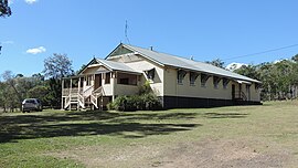
54:Samsonvale & Districts Public Hall, 2020
495:is now only a passenger service within the
1101:
1087:
1079:
1024:
990:
858:– via National Library of Australia.
826:– via National Library of Australia.
751:Queensland Family History Society (2010),
622:
379:View of Mount Samson from Golds Scrub Lane
48:
31:
784:Samsonvale Presbyterian Church memorial
589:
471:Samsonvale Presbyterian Church (former)
634:
632:
427:Samsonvale Provisional School (former)
1109:Towns, suburbs and localities in the
931:from the original on 25 February 2012
732:from the original on 29 November 2014
700:"Pine Rivers other historical topics"
304:
289:
272:
265:
7:
1641:Local government areas of Queensland
925:"Our History - Pine Rivers District"
880:from the original on 3 February 2021
850:from the original on 3 February 2021
791:from the original on 3 February 2021
777:
775:
810:"GERMAN ANNEXATIONS IN THE PACIFIC"
753:Queensland schools past and present
706:from the original on 3 October 2009
184:33.8 km (13.1 sq mi)
1660:Suburbs of the City of Moreton Bay
72:
25:
870:"Samsonvale | Moreton Bay Region"
757:Queensland Family History Society
726:"Samsonvale - Queensland Places"
343:, Queensland, Australia. In the
217:36.7 km (23 mi) NW of
71:
64:
1005:Australian Bureau of Statistics
971:Australian Bureau of Statistics
603:Australian Bureau of Statistics
211:22.6 km (14 mi) W of
130:Samsonvale (centre of locality)
1042:Gold, A. J; Gold, Ken (1996),
1:
355:The district is dominated by
668:Petrie, Constance Campbell;
975:"Samsonvale (State Suburb)"
728:. Queenslandplaces.com.au.
390:is named after the family.
158:19.94/km (51.65/sq mi)
1681:
268:Suburbs around Samsonvale:
1637:
1124:
954:October 12, 2009, at the
927:. Moretonbay.qld.gov.au.
755:(Version 1.01 ed.),
702:. Moretonbay.qld.gov.au.
322:
266:
262:
90:
59:
47:
1665:Localities in Queensland
516:The construction of the
493:Ferny Grove railway line
489:Dayboro railway station
485:Samford railway station
1013:2016 Census QuickStats
979:2011 Census QuickStats
644:Queensland Place Names
611:2021 Census QuickStats
460:27.26879°S 152.85901°E
416:27.26789°S 152.85904°E
380:
648:Queensland Government
378:
815:The Brisbane Courier
520:and the flooding of
511:Dayboro railway line
465:-27.26879; 152.85901
421:-27.26789; 152.85904
119:27.2619°S 152.8580°E
1111:City of Moreton Bay
973:(31 October 2012).
899:Kerr, John (1990).
455: /
411: /
341:City of Moreton Bay
252:Federal division(s)
240:State electorate(s)
233:City of Moreton Bay
114: /
1259:Commissioners Flat
1009:"Samsonvale (SSC)"
787:, 7 January 2007,
607:"Samsonvale (SAL)"
381:
124:-27.2619; 152.8580
1647:
1646:
1072:Queensland Places
1053:978-0-9596428-8-9
910:978-0-86439-102-5
766:978-1-921171-26-0
683:978-0-7022-2383-9
330:
329:
326:
325:
16:(Redirected from
1672:
1564:Upper Caboolture
1224:Campbells Pocket
1214:Caboolture South
1103:
1096:
1089:
1080:
1075:
1056:
1029:
1028:
1023:
1021:
1019:
1007:(27 June 2017).
1001:
995:
994:
989:
987:
985:
967:
958:
947:
941:
940:
938:
936:
921:
915:
914:
896:
890:
889:
887:
885:
866:
860:
859:
857:
855:
843:The Queenslander
834:
828:
827:
825:
823:
806:
800:
799:
798:
796:
779:
770:
769:
748:
742:
741:
739:
737:
722:
716:
715:
713:
711:
696:
687:
686:
665:
659:
658:
656:
654:
636:
627:
626:
621:
619:
617:
605:(28 June 2022).
599:
497:City of Brisbane
479:
478:
476:
475:
474:
472:
467:
466:
461:
456:
453:
452:
451:
448:
435:
434:
432:
431:
430:
428:
423:
422:
417:
412:
409:
408:
407:
404:
359:, the waters of
264:
138:
137:
135:
134:
133:
131:
126:
125:
120:
115:
112:
111:
110:
107:
75:
74:
68:
52:
43:
37:
32:
21:
1680:
1679:
1675:
1674:
1673:
1671:
1670:
1669:
1650:
1649:
1648:
1643:
1633:
1609:Wights Mountain
1534:Sandstone Point
1524:Samford Village
1204:Burpengary East
1139:Armstrong Creek
1120:
1107:
1066:
1063:
1054:
1041:
1038:
1036:Further reading
1033:
1032:
1017:
1015:
1003:
1002:
998:
983:
981:
969:
968:
961:
956:Wayback Machine
948:
944:
934:
932:
923:
922:
918:
911:
898:
897:
893:
883:
881:
868:
867:
863:
853:
851:
836:
835:
831:
821:
819:
808:
807:
803:
794:
792:
781:
780:
773:
767:
750:
749:
745:
735:
733:
724:
723:
719:
709:
707:
698:
697:
690:
684:
667:
666:
662:
652:
650:
638:
637:
630:
615:
613:
601:
600:
591:
586:
578:
552:
544:Lake Samsonvale
540:Lake Samsonvale
522:Lake Samsonvale
470:
468:
464:
462:
458:
457:
454:
449:
446:
444:
442:
441:
426:
424:
420:
418:
414:
413:
410:
405:
402:
400:
398:
397:
373:
357:Lake Samsonvale
353:
275:Armstrong Creek
155: • Density
129:
127:
123:
121:
117:
116:
113:
108:
105:
103:
101:
100:
86:
85:
84:
83:
82:
81:
80:
76:
55:
39:
38:
35:
30:
23:
22:
15:
12:
11:
5:
1678:
1676:
1668:
1667:
1662:
1652:
1651:
1645:
1644:
1639:Main Article:
1638:
1635:
1634:
1632:
1631:
1626:
1621:
1616:
1611:
1606:
1601:
1596:
1591:
1586:
1581:
1576:
1571:
1566:
1561:
1556:
1551:
1546:
1541:
1536:
1531:
1526:
1521:
1519:Samford Valley
1516:
1511:
1506:
1501:
1496:
1491:
1486:
1481:
1476:
1471:
1466:
1461:
1456:
1454:Murrumba Downs
1451:
1446:
1444:Mount Pleasant
1441:
1436:
1431:
1429:Mount Glorious
1426:
1421:
1416:
1411:
1406:
1401:
1396:
1391:
1386:
1381:
1376:
1371:
1366:
1361:
1356:
1351:
1346:
1344:Jollys Lookout
1341:
1336:
1331:
1326:
1321:
1316:
1311:
1306:
1301:
1296:
1291:
1289:Delaneys Creek
1286:
1281:
1276:
1271:
1266:
1261:
1256:
1251:
1246:
1244:Clear Mountain
1241:
1236:
1231:
1226:
1221:
1216:
1211:
1206:
1201:
1196:
1191:
1186:
1181:
1176:
1171:
1166:
1161:
1156:
1151:
1146:
1141:
1136:
1131:
1125:
1122:
1121:
1108:
1106:
1105:
1098:
1091:
1083:
1077:
1076:
1062:
1061:External links
1059:
1058:
1057:
1052:
1037:
1034:
1031:
1030:
996:
959:
942:
916:
909:
891:
861:
838:"Current News"
829:
801:
771:
765:
743:
717:
688:
682:
660:
628:
588:
587:
585:
582:
577:
574:
551:
548:
518:North Pine Dam
504:North Pine Dam
372:
369:
361:North Pine Dam
352:
349:
328:
327:
324:
323:
320:
319:
314:
309:
307:Mount Glorious
303:
302:
297:
294:
288:
287:
282:
277:
271:
270:
260:
259:
254:
248:
247:
242:
236:
235:
230:
224:
223:
222:
221:
215:
207:
203:
202:
192:
186:
185:
182:
178:
177:
174:
168:
167:
164:
160:
159:
156:
152:
151:
144:
140:
139:
98:
92:
91:
88:
87:
78:
77:
70:
69:
63:
62:
61:
60:
57:
56:
53:
45:
44:
28:
24:
14:
13:
10:
9:
6:
4:
3:
2:
1677:
1666:
1663:
1661:
1658:
1657:
1655:
1642:
1636:
1630:
1627:
1625:
1622:
1620:
1617:
1615:
1612:
1610:
1607:
1605:
1602:
1600:
1597:
1595:
1592:
1590:
1587:
1585:
1582:
1580:
1579:Wamuran Basin
1577:
1575:
1572:
1570:
1569:Wagtail Grove
1567:
1565:
1562:
1560:
1557:
1555:
1552:
1550:
1547:
1545:
1542:
1540:
1537:
1535:
1532:
1530:
1527:
1525:
1522:
1520:
1517:
1515:
1512:
1510:
1507:
1505:
1502:
1500:
1497:
1495:
1492:
1490:
1487:
1485:
1482:
1480:
1477:
1475:
1472:
1470:
1467:
1465:
1462:
1460:
1457:
1455:
1452:
1450:
1447:
1445:
1442:
1440:
1437:
1435:
1432:
1430:
1427:
1425:
1424:Mount Delaney
1422:
1420:
1417:
1415:
1412:
1410:
1407:
1405:
1402:
1400:
1397:
1395:
1392:
1390:
1387:
1385:
1382:
1380:
1377:
1375:
1372:
1370:
1367:
1365:
1362:
1360:
1357:
1355:
1352:
1350:
1347:
1345:
1342:
1340:
1337:
1335:
1332:
1330:
1327:
1325:
1322:
1320:
1317:
1315:
1314:Everton Hills
1312:
1310:
1307:
1305:
1302:
1300:
1297:
1295:
1292:
1290:
1287:
1285:
1284:Deception Bay
1282:
1280:
1277:
1275:
1272:
1270:
1267:
1265:
1262:
1260:
1257:
1255:
1252:
1250:
1247:
1245:
1242:
1240:
1237:
1235:
1232:
1230:
1227:
1225:
1222:
1220:
1219:Camp Mountain
1217:
1215:
1212:
1210:
1207:
1205:
1202:
1200:
1197:
1195:
1192:
1190:
1187:
1185:
1182:
1180:
1177:
1175:
1172:
1170:
1167:
1165:
1162:
1160:
1157:
1155:
1152:
1150:
1147:
1145:
1144:Banksia Beach
1142:
1140:
1137:
1135:
1132:
1130:
1127:
1126:
1123:
1119:
1116:
1112:
1104:
1099:
1097:
1092:
1090:
1085:
1084:
1081:
1073:
1069:
1065:
1064:
1060:
1055:
1049:
1045:
1040:
1039:
1035:
1027:
1014:
1010:
1006:
1000:
997:
993:
980:
976:
972:
966:
964:
960:
957:
953:
950:
946:
943:
930:
926:
920:
917:
912:
906:
902:
895:
892:
879:
875:
874:Moreton Daily
871:
865:
862:
849:
845:
844:
839:
833:
830:
817:
816:
811:
805:
802:
790:
786:
785:
778:
776:
772:
768:
762:
758:
754:
747:
744:
731:
727:
721:
718:
705:
701:
695:
693:
689:
685:
679:
675:
671:
664:
661:
649:
645:
641:
635:
633:
629:
625:
612:
608:
604:
598:
596:
594:
590:
583:
581:
575:
573:
571:
566:
564:
559:
557:
549:
547:
545:
541:
536:
534:
529:
525:
523:
519:
514:
512:
507:
505:
500:
498:
494:
490:
486:
481:
477:
437:
433:
394:
391:
389:
384:
377:
370:
368:
366:
362:
358:
350:
348:
346:
342:
338:
334:
321:
318:
315:
313:
310:
308:
305:
301:
298:
295:
293:
290:
286:
283:
281:
278:
276:
273:
269:
261:
258:
255:
253:
249:
246:
243:
241:
237:
234:
231:
229:
225:
220:
216:
214:
210:
209:
208:
204:
200:
196:
193:
191:
187:
183:
179:
175:
173:
169:
165:
161:
157:
153:
149:
145:
141:
136:
99:
97:
93:
89:
67:
58:
51:
46:
42:
33:
27:
19:
1528:
1449:Mount Samson
1379:Laceys Creek
1369:Kobble Creek
1324:Godwin Beach
1129:Albany Creek
1071:
1068:"Samsonvale"
1043:
1016:. Retrieved
1012:
999:
984:26 September
982:. Retrieved
978:
945:
933:. Retrieved
919:
900:
894:
882:. Retrieved
873:
864:
852:. Retrieved
841:
832:
820:. Retrieved
813:
804:
793:, retrieved
783:
752:
746:
734:. Retrieved
720:
708:. Retrieved
673:
663:
651:. Retrieved
643:
614:. Retrieved
610:
579:
567:
560:
553:
550:Demographics
537:
533:Kobble Creek
530:
526:
515:
508:
501:
482:
438:
395:
392:
385:
382:
365:Mount Samson
354:
332:
331:
312:Mount Samson
292:Kobble Creek
267:
219:Brisbane CBD
26:
1619:Woody Point
1599:White Patch
1549:Stony Creek
1539:Scarborough
1479:North Lakes
1319:Ferny Hills
1304:Eatons Hill
1234:Cedar Creek
1134:Arana Hills
935:15 November
736:15 November
710:15 November
670:Petrie, Tom
653:16 November
616:28 February
576:Attractions
570:2021 census
563:2016 census
556:2011 census
535:community.
463: /
450:152°51′32″E
419: /
406:152°51′33″E
345:2021 census
335:is a rural
245:Pine Rivers
172:Postcode(s)
163:Established
148:2021 census
122: /
109:152°51′29″E
96:Coordinates
1654:Categories
1554:Strathpine
1529:Samsonvale
1509:Rush Creek
1484:Ocean View
1439:Mount Nebo
1419:Morayfield
1394:Mango Hill
1374:Kurwongbah
1364:Kippa-Ring
1359:King Scrub
1329:Greenstone
1294:Donnybrook
1209:Caboolture
1199:Burpengary
1164:Bellthorpe
1118:Queensland
1115:South East
1018:20 October
884:3 February
854:3 February
795:3 February
584:References
469: (
447:27°16′08″S
425: (
403:27°16′04″S
333:Samsonvale
296:Samsonvale
285:Rush Creek
213:Strathpine
146:674 (
143:Population
128: (
106:27°15′43″S
79:Samsonvale
41:Queensland
36:Samsonvale
18:Samsonvale
1604:Whiteside
1499:Rocksberg
1494:Redcliffe
1434:Mount Mee
1354:Kallangur
1269:D'Aguilar
1254:Closeburn
1184:Bray Park
1174:Booroobin
1149:Beachmere
351:Geography
300:Whiteside
199:UTC+10:00
190:Time zone
1614:Woodford
1544:Stanmore
1504:Rothwell
1459:Narangba
1389:Lilywood
1339:Highvale
1264:Corymbia
1249:Clontarf
1239:Cedarton
1229:Cashmere
1189:Brendale
1179:Bracalba
1169:Bongaree
1159:Bellmere
952:Archived
929:Archived
878:Archived
848:Archived
789:archived
730:Archived
704:Archived
672:(1992),
337:locality
317:Cashmere
206:Location
1574:Wamuran
1559:Toorbul
1514:Samford
1469:Newport
1414:Moorina
1404:Meldale
1399:Margate
1384:Lawnton
1334:Griffin
1309:Elimbah
1279:Dayboro
1274:Dakabin
1154:Bellara
568:In the
561:In the
554:In the
371:History
339:in the
280:Dayboro
257:Dickson
1624:Woorim
1594:Welsby
1589:Warner
1584:Waraba
1489:Petrie
1464:Neurum
1409:Moodlu
1349:Joyner
1299:Draper
1050:
907:
822:7 June
763:
680:
388:Joyner
228:LGA(s)
1629:Yugar
1474:Ningi
1194:Bunya
1048:ISBN
1020:2018
986:2014
937:2014
905:ISBN
886:2021
856:2021
824:2024
797:2021
761:ISBN
738:2014
712:2014
678:ISBN
655:2019
618:2023
195:AEST
181:Area
176:4520
166:1845
436:).
1656::
1113:,
1070:.
1011:.
977:.
962:^
876:.
872:.
840:.
812:.
774:^
759:,
691:^
646:.
642:.
631:^
609:.
592:^
513:.
506:.
367:.
1102:e
1095:t
1088:v
1022:.
988:.
939:.
913:.
888:.
740:.
714:.
657:.
620:.
473:)
429:)
201:)
197:(
150:)
132:)
20:)
Text is available under the Creative Commons Attribution-ShareAlike License. Additional terms may apply.