64:
1706:
1523:
870:
860:
880:
850:
840:
655:
Of the 4,810 households 31.8% had children under the age of 18 living with them, 61.0% were married couples living together, 10.5% had a female householder with no husband present, and 25.1% were non-families. 21.2% of households were one person and 8.1% were one person aged 65 or older. The average
461:
to handle all land transactions. Some of the pioneer families who seized the opportunity to buy up sections were named
Alvarez, Rice, Hartley, Moore, LaCoste, Williams, Tool and Cleveland. Eventually, Alvarez Station was called Cleveland Station. The present name of the city is reported to have been
491:
with 220 passengers and crew aboard, crossed the Bayou Canot bridge at high speed and derailed at a kink in the track caused by a barge captain who rammed the bridge by making a wrong turn in the waterway and failed to report the accident. 47 people, of whom 42 were passengers, were killed, many by
465:
Saraland was sparsely populated during the first part of the 20th century, until an industrial and population boom occurred in neighboring Mobile. Northward expansion of Mobile in the 1940s and 50s brought about the incorporation of
Saraland in 1957. At the time of incorporation, the city reported
456:
The land area that was to become the present-day
Saraland was included in a Spanish land grant to Don Diego Alvarez. Hence, descendants of Alvarez were the ones to give the community its first name: Alvarez Station. Later land squatters moved into the area and were able, legally, in 1800 to begin
956:
and form its own school system. The school district came into effect in autumn 2008; at the time
Saraland Elementary and Adams Middle were a part of the city district, but high schoolers had to attend county schools because Saraland High School was not yet open. Prior to the split of the City of
689:
Of the 5,208 households 27.9% had children under the age of 18 living with them, 54.4% were married couples living together, 13.4% had a female householder with no husband present, and 27.9% were non-families. 22.8% of households were one person and 10.0% were one person aged 65 or older. The
659:
The age distribution was 23.4% under the age of 18, 9.4% from 18 to 24, 29.3% from 25 to 44, 24.4% from 45 to 64, and 13.5% 65 or older. The median age was 37 years. For every 100 females, there were 95.4 males. For every 100 females age 18 and over, there were 92.2 males.
693:
The age distribution was 22.9% under the age of 18, 8.0% from 18 to 24, 25.8% from 25 to 44, 27.5% from 45 to 64, and 15.8% 65 or older. The median age was 40 years. For every 100 females, there were 97.7 males. For every 100 females age 18 and over, there were 101.9 males.
697:
The median household income was $ 48,721 and the median family income was $ 54,845. Males had a median income of $ 44,201 versus $ 31,235 for females. The per capita income for the city was $ 22,192. About 8.8% of families and 14.9% of the population were below the
663:
The median household income was $ 38,318 and the median family income was $ 43,471. Males had a median income of $ 35,431 versus $ 22,787 for females. The per capita income for the city was $ 19,470. About 7.4% of families and 9.0% of the population were below the
646:
there were 12,288 people in 4,810 households, including 3,602 families, in the city. The population density was 560.9 inhabitants per square mile (216.6/km). There were 5,138 housing units at an average density of 234.5 per square mile (90.5/km). The
680:
there were 13,405 people in 5,208 households, including 3,757 families, in the city. The population density was 558.5 inhabitants per square mile (215.6/km). There were 5,828 housing units at an average density of 266.1 per square mile (102.7/km). The
651:
of the city was 88.50% White, 8.97% Black or
African American, 0.56% Native American, 0.46% Asian, 0.01% Pacific Islander, 0.37% from other races, and 1.13% from two or more races. 1.17% of the population were Hispanic or Latino of any race.
685:
of the city was 83.7% White, 12.0% Black or
African American, 0.8% Native American, 0.6% Asian, 0.1% Pacific Islander, 1.5% from other races, and 1.4% from two or more races. 2.5% of the population were Hispanic or Latino of any race.
919:, due to high wildfire hazard potential, flood hazard, or potential for damage in Category 4 or 5 hurricanes. As of September 2, 2014, Redwing Carriers, Inc. in Saraland was removed from the National Priorities List (NPL) because no
462:
given by C.J. DeWitt, a retired minister editor who moved south in 1890 for health reasons. He opened the first post office on the
Southern Railroad in 1895. The community is purported to be the namesake of his beloved wife, Sara.
63:
466:
only 125 residents. By the 1960 U.S. Census, annexations had swelled the population to 4,595. In 1980, census figures cited 9,844 Saraland residents. As of the 2020 census, Saraland's population had grown to 16,171.
444:, Saraland has a total area of 32.4 square miles (84 km), of which 0.32 square miles (0.83 km), or 0.68%, are water. The city is drained by Bayou Sara, an east-flowing tributary of the
492:
drowning, others by fire. Much of the rescue efforts were average citizens of the community who journeyed out in the early morning hours in small fishing boats to help at the scene.
1339:
1604:
682:
648:
2009:
980:
Private schools within
Saraland include Evangel Christian School, North Mobile Christian School, and the Saraland Yeshiva right outside of the city limits.
2004:
77:
295:
425:
are the main north-south routes through
Saraland. U.S. 43 leads south 9 miles (14 km) to downtown Mobile and north 55 miles (89 km) to
1753:
1597:
916:
305:
1824:
953:
1259:
246:
945:. Residents are zoned to Saraland Early Education Center, Saraland Elementary School, Saraland (formerly Adams) Middle School, and
371:
1834:
1336:
1072:
1590:
781:
741:
1553:
1400:
1099:
1582:
1121:
755:
474:
161:
1945:
1011:
1244:
1198:
1173:
1125:
942:
794:
131:
1219:
1467:
1999:
826:
677:
643:
616:
601:
586:
571:
556:
541:
526:
353:
1894:
1819:
1794:
1041:
1024:
1008:
843:
357:
283:
109:
1362:
961:. 2011 was the final year in which Saraland residents were permitted by the county to attend county schools.
1740:
1725:
1655:
989:
912:
873:
863:
1969:
1614:
1424:
883:
807:
337:
136:
1927:
1899:
1884:
1814:
1730:
1405:
1386:
999:
458:
143:
1381:
1976:
1528:
946:
811:
256:
1839:
1804:
1665:
958:
768:
727:
434:
356:, the population of the city was 16,171, up from 13,405 at the 2010 census. Saraland, part of the
1937:
1879:
1854:
1849:
1779:
1774:
1769:
1660:
969:
904:
441:
404:
1147:
1904:
1889:
1874:
1864:
1844:
1789:
1680:
895:
400:
1763:
1690:
965:
426:
408:
1285:
1909:
1869:
1859:
1784:
1695:
1675:
1670:
1636:
1367:
1343:
1048:
1020:
920:
853:
412:
349:
1420:
1445:
1829:
1758:
1015:
829:, there were 16,171 people, 5,171 households, and 3,615 families residing in the city.
479:
1993:
1748:
1310:
1037:
1031:
1027:
430:
422:
418:
288:
699:
665:
445:
407:, to the east by the undeveloped northern end of Mobile, and to the northeast by
1629:
484:
1919:
1518:
1044:
1004:
898:
used to operate the
Saraland Refinery in Saraland, now owned by Vertex Energy.
119:
1568:
1555:
1492:
386:
373:
92:
79:
995:
237:
1323:
702:, including 28.3% of those under age 18 and 7.0% of those age 65 or over.
668:, including 12.2% of those under age 18 and 8.9% of those age 65 or over.
1960:‡This populated place also has portions in an adjacent county or counties
271:
869:
859:
399:(30.825186, -88.091932). It is bordered to the southwest by the city of
17:
879:
341:
124:
690:
average household size was 2.57 and the average family size was 2.01.
470:
345:
911:
Redwing Carriers, Inc. in Saraland had been identified as having a
1545:
488:
429:, while I-65 leads south 15 miles (24 km) to its terminus at
263:
242:
169:
1705:
1100:"Saraland city, Alabama: 2020 DEC Redistricting Data (PL 94-171)"
433:
in southwestern Mobile, and northeast 157 miles (253 km) to
1717:
1647:
1348:
952:
In June 2006, the City of Saraland voted to break away from the
849:
46:
1586:
1326:." Saraland Chamber of Commerce. Retrieved on October 22, 2010.
957:
Saraland from the county system in 2009, Saraland was zoned to
839:
656:
household size was 2.55 and the average family size was 2.97.
1260:"Report: Climate change threatens 11 Alabama superfund sites"
1704:
1390:. Monday December 12, 2011. Retrieved on November 17, 2012.
1352:. Saturday November 3, 2007. Retrieved on October 22, 2010.
1538:
1245:"Shell sells Mobile Chemical LP Refinery to Vertex Energy"
477:
on September 22, 1993. At approximately 2:53 AM, Amtrak's
457:
purchasing property. In 1807, a land office was opened in
320:
1468:"Bears select Velus Jones with No. 71 pick in 2022 draft"
1194:
1169:
1371:. Tuesday June 23, 2009. Retrieved on November 17, 2012.
1313:." Saraland City Schools. Retrieved on October 22, 2010.
483:
train, powered by three locomotives, and en route from
1409:. Friday March 27, 2009. Retrieved on March 31, 2009.
1067:
1065:
1401:
Chickasaw officials to examine possible school split
1382:
Mobile County school system sees dropping enrollment
1955:
1936:
1918:
1803:
1739:
1716:
1646:
964:Several years prior to 2009 officials of Saraland,
315:
304:
294:
282:
270:
253:
236:
228:
220:
215:
207:
199:
191:
183:
178:
167:
157:
152:
142:
130:
118:
108:
37:
972:contemplated forming the "Delta School District."
1286:"REDWING CARRIERS, INC. (SARALAND) Site Profile"
360:, is the third largest city in Mobile County.
1598:
1094:
1092:
1090:
8:
1605:
1591:
1583:
1122:"US Gazetteer files: 2010, 2000, and 1990"
499:
469:The worst rail disaster in the history of
34:
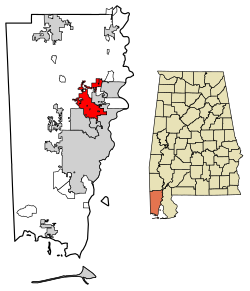
1709:Map of Alabama highlighting Mobile County
1421:"Ann Casey: More than just a pretty face"
709:
1258:Burkhalter, Eddie (November 22, 2019).
1061:
314:
293:
269:
235:
214:
206:
177:
151:
141:
107:
72:
60:
52:
519:
303:
281:
252:
227:
219:
198:
195:32.15 sq mi (83.27 km)
190:
187:32.37 sq mi (83.84 km)
182:
166:
156:
129:
117:
7:
2010:Populated places established in 1957
1493:"Cordale Flott #28 New York Giants"
203:0.22 sq mi (0.57 km)
1613:Municipalities and communities of
1337:Saraland School System Coming Soon
954:Mobile County Public School System
509:
473:occurred just east of Saraland on
68:Location in Mobile County, Alabama
25:
1546:Saraland Area Chamber of Commerce
1363:Vickers accepts Saraland position
901:Alorica Telecommunications Center
2005:Cities in Mobile County, Alabama
1521:
878:
868:
858:
848:
838:
62:
992:, Professional Baseball Pitcher
32:City in Alabama, United States
27:City in Alabama, United States
1:
1075:. United States Census Bureau
932:Primary and secondary schools
232:502.97/sq mi (194.20/km)
907:, a brand of rice and beans.
711:Saraland racial composition
1199:United States Census Bureau
1174:United States Census Bureau
1126:United States Census Bureau
1073:"2021 U.S. Gazetteer Files"
943:Saraland Board of Education
2026:
1264:Alabama Political Reporter
941:Saraland is served by the
1965:
1702:
1627:
827:2020 United States census
742:Black or African American
630:
615:
600:
585:
570:
555:
540:
525:
518:
513:
508:
505:
421:(Saraland Boulevard) and
73:
61:
53:
44:
1946:MOWA Choctaw Reservation
1042:National Football League
1025:National Football League
1009:National Football League
358:Mobile metropolitan area
1569:30.825186°N 88.091932°W
1399:Philips, Rena Havner. "
1380:Philips, Rena Havner. "
1148:"U.S. Decennial Census"
990:Matt Peacock (baseball)
915:which was at risk from
368:Saraland is located at
344:, United States, and a
1710:
1616:Mobile County, Alabama
1425:Cauliflower Alley Club
1708:
1574:30.825186; -88.091932
1406:Mobile Press-Register
1387:Mobile Press-Register
1220:"Explore Census Data"
1195:"U.S. Census website"
1170:"U.S. Census website"
1000:professional wrestler
631:U.S. Decennial Census
501:Historical population
437:, the state capital.
387:30.82528°N 88.09194°W
255: • Summer (
211:13 ft (4 m)
174:Dr. Howard Rubenstein
93:30.82528°N 88.09194°W
56:"Gateway to Progress"
1978:United States portal
1529:United States portal
1102:. U.S. Census Bureau
947:Saraland High School
229: • Density
1565: /
1128:. February 12, 2011
959:Satsuma High School
712:
502:
392:30.82528; -88.09194
383: /
98:30.82528; -88.09194
89: /
1938:Indian reservation
1711:
1342:2009-08-08 at the
710:
500:
442:U.S. Census Bureau
403:, to the south by
221: • Total
200: • Water
184: • Total
2000:Cities in Alabama
1987:
1986:
923:remains on site.
896:Royal Dutch Shell
823:
822:
635:
634:
440:According to the
331:
330:
192: • Land
158: • Type
39:Saraland, Alabama
16:(Redirected from
2017:
1979:
1972:
1707:
1639:
1632:
1622:
1617:
1607:
1600:
1593:
1584:
1580:
1579:
1577:
1576:
1575:
1570:
1566:
1563:
1562:
1561:
1558:
1542:
1541:
1539:Official website
1531:
1526:
1525:
1524:
1508:
1507:
1505:
1503:
1489:
1483:
1482:
1480:
1478:
1464:
1458:
1457:
1455:
1453:
1442:
1436:
1435:
1433:
1431:
1416:
1410:
1397:
1391:
1378:
1372:
1361:Cannon, Jason. "
1359:
1353:
1333:
1327:
1320:
1314:
1307:
1301:
1300:
1298:
1296:
1281:
1275:
1274:
1272:
1270:
1255:
1249:
1248:
1241:
1235:
1234:
1232:
1230:
1216:
1210:
1209:
1207:
1205:
1191:
1185:
1184:
1182:
1180:
1166:
1160:
1159:
1157:
1155:
1144:
1138:
1137:
1135:
1133:
1118:
1112:
1111:
1109:
1107:
1096:
1085:
1084:
1082:
1080:
1069:
882:
872:
862:
852:
842:
782:Pacific Islander
713:
521:
516:
511:
503:
398:
397:
395:
394:
393:
388:
384:
381:
380:
379:
376:
327:
324:
322:
260:
104:
103:
101:
100:
99:
94:
90:
87:
86:
85:
82:
66:
35:
21:
2025:
2024:
2020:
2019:
2018:
2016:
2015:
2014:
1990:
1989:
1988:
1983:
1977:
1970:
1961:
1951:
1932:
1914:
1895:Tanner Williams
1820:Churchill Downs
1806:
1799:
1795:Tillmans Corner
1735:
1712:
1700:
1642:
1637:
1630:
1623:
1620:
1615:
1611:
1573:
1571:
1567:
1564:
1559:
1556:
1554:
1552:
1551:
1537:
1536:
1527:
1522:
1520:
1517:
1512:
1511:
1501:
1499:
1491:
1490:
1486:
1476:
1474:
1466:
1465:
1461:
1451:
1449:
1444:
1443:
1439:
1429:
1427:
1419:Kociaba, Bill.
1418:
1417:
1413:
1398:
1394:
1379:
1375:
1368:Demopolis Times
1360:
1356:
1344:Wayback Machine
1335:Lucio, Diana. "
1334:
1330:
1321:
1317:
1308:
1304:
1294:
1292:
1290:cumulis.epa.gov
1284:US EPA, OSRTI.
1283:
1282:
1278:
1268:
1266:
1257:
1256:
1252:
1247:. May 27, 2021.
1243:
1242:
1238:
1228:
1226:
1224:data.census.gov
1218:
1217:
1213:
1203:
1201:
1193:
1192:
1188:
1178:
1176:
1168:
1167:
1163:
1153:
1151:
1146:
1145:
1141:
1131:
1129:
1120:
1119:
1115:
1105:
1103:
1098:
1097:
1088:
1078:
1076:
1071:
1070:
1063:
1058:
1049:New York Giants
1021:Velus Jones, Jr
986:
978:
976:Private schools
939:
934:
929:
921:hazardous waste
892:
835:
756:Native American
744:(non-Hispanic)
730:(non-Hispanic)
708:
674:
640:
514:
498:
475:Big Bayou Canot
454:
391:
389:
385:
382:
377:
374:
372:
370:
369:
366:
319:
278:
254:
97:
95:
91:
88:
83:
80:
78:
76:
75:
69:
57:
49:
40:
33:
28:
23:
22:
15:
12:
11:
5:
2023:
2021:
2013:
2012:
2007:
2002:
1992:
1991:
1985:
1984:
1982:
1981:
1974:
1971:Alabama portal
1966:
1963:
1962:
1959:
1957:
1953:
1952:
1950:
1949:
1942:
1940:
1934:
1933:
1931:
1930:
1924:
1922:
1916:
1915:
1913:
1912:
1907:
1902:
1897:
1892:
1887:
1882:
1877:
1872:
1867:
1862:
1857:
1852:
1847:
1842:
1837:
1832:
1827:
1822:
1817:
1811:
1809:
1805:Unincorporated
1801:
1800:
1798:
1797:
1792:
1787:
1782:
1777:
1772:
1767:
1761:
1756:
1754:Belle Fontaine
1751:
1745:
1743:
1737:
1736:
1734:
1733:
1728:
1726:Dauphin Island
1722:
1720:
1714:
1713:
1703:
1701:
1699:
1698:
1693:
1688:
1683:
1678:
1673:
1668:
1663:
1658:
1656:Bayou La Batre
1652:
1650:
1644:
1643:
1628:
1625:
1624:
1612:
1610:
1609:
1602:
1595:
1587:
1549:
1548:
1543:
1533:
1532:
1516:
1515:External links
1513:
1510:
1509:
1484:
1459:
1437:
1411:
1392:
1373:
1354:
1328:
1315:
1302:
1276:
1250:
1236:
1211:
1186:
1161:
1139:
1113:
1086:
1060:
1059:
1057:
1054:
1053:
1052:
1035:
1018:
1016:Houston Texans
1002:
993:
985:
984:Notable people
982:
977:
974:
938:
937:Public schools
935:
933:
930:
928:
925:
917:climate change
913:Superfund site
909:
908:
902:
899:
891:
888:
887:
886:
876:
866:
856:
846:
834:
833:Transportation
831:
821:
820:
817:
814:
804:
803:
800:
797:
791:
790:
787:
784:
778:
777:
774:
771:
765:
764:
761:
758:
752:
751:
748:
745:
738:
737:
734:
731:
724:
723:
720:
717:
707:
704:
673:
670:
639:
636:
633:
632:
628:
627:
624:
622:
619:
613:
612:
609:
607:
604:
598:
597:
594:
592:
589:
583:
582:
579:
577:
574:
568:
567:
564:
562:
559:
553:
552:
549:
547:
544:
538:
537:
534:
532:
529:
523:
522:
517:
512:
507:
497:
494:
480:Sunset Limited
453:
450:
365:
362:
329:
328:
317:
313:
312:
309:
302:
301:
298:
292:
291:
286:
280:
279:
276:
274:
268:
267:
261:
251:
250:
240:
234:
233:
230:
226:
225:
222:
218:
217:
213:
212:
209:
205:
204:
201:
197:
196:
193:
189:
188:
185:
181:
180:
176:
175:
172:
165:
164:
159:
155:
154:
150:
149:
146:
140:
139:
134:
128:
127:
122:
116:
115:
112:
106:
105:
71:
70:
67:
59:
58:
55:
51:
50:
45:
42:
41:
38:
31:
26:
24:
14:
13:
10:
9:
6:
4:
3:
2:
2022:
2011:
2008:
2006:
2003:
2001:
1998:
1997:
1995:
1980:
1975:
1973:
1968:
1967:
1964:
1958:
1954:
1947:
1944:
1943:
1941:
1939:
1935:
1929:
1926:
1925:
1923:
1921:
1917:
1911:
1908:
1906:
1903:
1901:
1898:
1896:
1893:
1891:
1888:
1886:
1883:
1881:
1878:
1876:
1873:
1871:
1868:
1866:
1863:
1861:
1858:
1856:
1853:
1851:
1848:
1846:
1843:
1841:
1838:
1836:
1833:
1831:
1828:
1826:
1823:
1821:
1818:
1816:
1813:
1812:
1810:
1808:
1802:
1796:
1793:
1791:
1788:
1786:
1783:
1781:
1778:
1776:
1773:
1771:
1768:
1765:
1762:
1760:
1757:
1755:
1752:
1750:
1747:
1746:
1744:
1742:
1738:
1732:
1729:
1727:
1724:
1723:
1721:
1719:
1715:
1697:
1694:
1692:
1689:
1687:
1684:
1682:
1679:
1677:
1674:
1672:
1669:
1667:
1664:
1662:
1659:
1657:
1654:
1653:
1651:
1649:
1645:
1641:
1640:
1633:
1626:
1621:United States
1618:
1608:
1603:
1601:
1596:
1594:
1589:
1588:
1585:
1581:
1578:
1547:
1544:
1540:
1535:
1534:
1530:
1519:
1514:
1502:September 18,
1498:
1494:
1488:
1485:
1473:
1469:
1463:
1460:
1447:
1441:
1438:
1426:
1422:
1415:
1412:
1408:
1407:
1402:
1396:
1393:
1389:
1388:
1383:
1377:
1374:
1370:
1369:
1364:
1358:
1355:
1351:
1350:
1345:
1341:
1338:
1332:
1329:
1325:
1319:
1316:
1312:
1306:
1303:
1291:
1287:
1280:
1277:
1265:
1261:
1254:
1251:
1246:
1240:
1237:
1225:
1221:
1215:
1212:
1200:
1196:
1190:
1187:
1175:
1171:
1165:
1162:
1149:
1143:
1140:
1127:
1123:
1117:
1114:
1101:
1095:
1093:
1091:
1087:
1074:
1068:
1066:
1062:
1055:
1050:
1046:
1043:
1039:
1038:Cordale Flott
1036:
1033:
1032:Chicago Bears
1029:
1028:wide receiver
1026:
1022:
1019:
1017:
1013:
1010:
1006:
1003:
1001:
997:
994:
991:
988:
987:
983:
981:
975:
973:
971:
967:
962:
960:
955:
950:
948:
944:
936:
931:
926:
924:
922:
918:
914:
906:
903:
900:
897:
894:
893:
889:
885:
881:
877:
875:
871:
867:
865:
861:
857:
855:
851:
847:
845:
844:Interstate 65
841:
837:
836:
832:
830:
828:
818:
815:
813:
809:
806:
805:
801:
798:
796:
793:
792:
788:
785:
783:
780:
779:
775:
772:
770:
767:
766:
762:
759:
757:
754:
753:
749:
746:
743:
740:
739:
735:
732:
729:
726:
725:
721:
718:
715:
714:
705:
703:
701:
695:
691:
687:
684:
683:racial makeup
679:
671:
669:
667:
661:
657:
653:
650:
649:racial makeup
645:
637:
629:
625:
623:
620:
618:
614:
610:
608:
605:
603:
599:
595:
593:
590:
588:
584:
580:
578:
575:
573:
569:
565:
563:
560:
558:
554:
550:
548:
545:
543:
539:
535:
533:
530:
528:
524:
504:
495:
493:
490:
486:
482:
481:
476:
472:
467:
463:
460:
451:
449:
447:
443:
438:
436:
432:
431:Interstate 10
428:
424:
423:Interstate 65
420:
419:U.S. Route 43
416:
414:
410:
406:
402:
396:
363:
361:
359:
355:
351:
347:
343:
339:
338:Mobile County
336:is a city in
335:
326:
318:
310:
307:
299:
297:
290:
287:
285:
275:
273:
265:
262:
258:
248:
247:Central (CST)
244:
241:
239:
231:
223:
210:
202:
194:
186:
173:
171:
168: •
163:
162:Mayor–council
160:
147:
145:
138:
135:
133:
126:
123:
121:
114:United States
113:
111:
102:
74:Coordinates:
65:
48:
43:
36:
30:
19:
1928:Beaver Mills
1900:Union Church
1885:Pennsylvania
1815:Alabama Port
1731:Mount Vernon
1685:
1635:
1550:
1500:. Retrieved
1496:
1487:
1475:. Retrieved
1471:
1462:
1450:. Retrieved
1446:"Jay Prosch"
1440:
1428:. Retrieved
1414:
1404:
1395:
1385:
1376:
1366:
1357:
1347:
1331:
1318:
1305:
1293:. Retrieved
1289:
1279:
1269:December 10,
1267:. Retrieved
1263:
1253:
1239:
1229:December 14,
1227:. Retrieved
1223:
1214:
1202:. Retrieved
1189:
1177:. Retrieved
1164:
1152:. Retrieved
1150:. Census.gov
1142:
1130:. Retrieved
1116:
1104:. Retrieved
1077:. Retrieved
979:
963:
951:
940:
910:
824:
700:poverty line
696:
692:
688:
675:
666:poverty line
662:
658:
654:
641:
496:Demographics
478:
468:
464:
459:St. Stephens
455:
446:Mobile River
439:
417:
367:
352:. As of the
333:
332:
144:Incorporated
54:Motto:
29:
1807:communities
1631:County seat
1572: /
1179:January 31,
795:Other/Mixed
706:2020 census
678:2010 census
672:2010 census
644:2000 census
638:2000 census
485:Los Angeles
390: /
354:2020 census
96: /
1994:Categories
1920:Ghost town
1840:Eight Mile
1825:Cloverdale
1666:Citronelle
1560:88°05′31″W
1557:30°49′31″N
1056:References
1045:Cornerback
1005:Jay Prosch
998:, retired
905:China Doll
825:As of the
435:Montgomery
375:30°49′31″N
308:feature ID
216:Population
153:Government
81:30°49′31″N
1956:Footnotes
1880:Mon Louis
1855:Irvington
1850:Heron Bay
1780:Gulfcrest
1775:Grand Bay
1770:Chunchula
1661:Chickasaw
1477:August 2,
1452:March 15,
1430:March 14,
1324:Education
1204:August 4,
1132:April 23,
1106:April 21,
1079:April 21,
996:Ann Casey
970:Chickasaw
927:Education
405:Chickasaw
378:88°5′31″W
364:Geography
323:.saraland
296:FIPS code
284:Area code
238:Time zone
208:Elevation
84:88°5′31″W
1905:Whistler
1890:St. Elmo
1875:Mauvilla
1865:Le Moyne
1845:Fernland
1835:Crawford
1790:Theodore
1686:Saraland
1681:Prichard
1340:Archived
1295:June 10,
1047:for the
1030:for the
1014:for the
1012:fullback
808:Hispanic
401:Prichard
334:Saraland
300:01-68160
272:ZIP code
18:Saraland
1764:Calvert
1691:Satsuma
1497:NFL.com
1472:NFL.com
1311:Schools
1154:June 6,
966:Satsuma
890:Economy
750:13.98%
736:76.54%
733:12,378
676:At the
642:At the
452:History
427:Jackson
409:Satsuma
342:Alabama
316:Website
311:0153329
125:Alabama
110:Country
1910:Wilmer
1870:Lloyds
1860:Kushla
1785:Movico
1696:Semmes
1676:Mobile
1671:Creola
1648:Cities
1638:Mobile
1448:. ESPN
968:, and
874:SR 213
864:SR 158
819:1.92%
812:Latino
802:4.95%
789:0.04%
776:1.17%
763:1.39%
747:2,261
722:Perc.
621:16,171
606:13,405
591:12,288
576:11,751
506:Census
471:Amtrak
413:Creola
350:Mobile
346:suburb
224:16,171
137:Mobile
132:County
1830:Coden
1759:Bucks
1718:Towns
884:SR 13
854:US 43
769:Asian
728:White
719:Num.
716:Race
626:20.6%
581:19.5%
566:25.4%
561:9,833
551:70.6%
546:7,840
531:4,595
489:Miami
277:36571
266:(CDT)
264:UTC-5
243:UTC-6
170:Mayor
120:State
1749:Axis
1741:CDPs
1504:2023
1479:2022
1454:2015
1432:2015
1349:WKRG
1297:2020
1271:2019
1231:2021
1206:2015
1181:2008
1156:2013
1134:2011
1108:2022
1081:2022
816:311
799:801
773:189
760:225
617:2020
611:9.1%
602:2010
596:4.6%
587:2000
572:1990
557:1980
542:1970
527:1960
515:Note
510:Pop.
411:and
325:.org
306:GNIS
179:Area
148:1957
47:City
1403:."
1384:."
1365:."
1346:."
810:or
487:to
348:of
321:www
289:251
257:DST
1996::
1634::
1619:,
1495:.
1470:.
1423:.
1288:.
1262:.
1222:.
1197:.
1172:.
1124:.
1089:^
1064:^
1040:,
1023:,
1007:,
949:.
786:6
520:%±
448:.
415:.
340:,
1948:‡
1766:‡
1606:e
1599:t
1592:v
1506:.
1481:.
1456:.
1434:.
1322:"
1309:"
1299:.
1273:.
1233:.
1208:.
1183:.
1158:.
1136:.
1110:.
1083:.
1051:.
1034:.
536:—
259:)
249:)
245:(
20:)
Text is available under the Creative Commons Attribution-ShareAlike License. Additional terms may apply.