520:
120:
506:
437:
64:
104:
89:
1027:
1017:
1007:
997:
1310:
1409:
425:
79:
1045:
987:
934:
913:
340:
977:
1259:
494:
127:
603:) characterized by warm summers and cool winters with light to no snowfall. The average annual temperature in Tatsuno is 14.4 °C. The average annual rainfall is 1519 mm with September as the wettest month. The temperatures are highest on average in August, at around 25.7 °C, and lowest in January, at around 3.7 °C.
897:
Tatsuno has 16 public elementary schools and five public middle schools operated by the city government and two public high schools operated by the Hyōgo
Prefectural Department of Education. There is also one private elementary school and one private middle school. The prefecture also operates two
63:
792:. The castle town's area from the early modern period is extant today in what is now the "old Tatsuno-chō area,” which still contains samurai residences and white-plastered earthen storehouses, giving the city the moniker of"Little Kyoto of Harima".
519:
68:
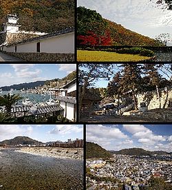
Top left:Tatsuno Castle, Top right:Tatsuno Park, Middle left:Port of
Murotsu, Middle right:iinonimasu Amaterasu Shrine, Bottom left:Ibo River, Bottom right:Panorama view of downtown Tatsuno
441:
412:
to make a grave, standing stones in a row on the plain. Thus, it was called "立野", with characters meaning "stand" and "plain", from which it is thought to have changed to "龍野".
505:
119:
448:
Tatsuno is located in southwestern Hyōgo
Prefecture extending largely south to north. The city's northern region is mountainous, the southern region faces the
1746:
440:
An aerial photo of central
Tatsuno and environs. Composed from eight photos taken in 1980. Created from the "Color Aerial Photographs" produced by the
151:
103:
1741:
1722:
795:
The town of
Tatsuno was established with the creation of the modern municipalities system on April 1, 1889. On October 1, 2005, the towns of
854:
88:
1299:
1408:
1094:
436:
1751:
1692:
1641:
937:
926:
916:
850:
545:
387:
1675:
1663:
1327:
1263:
951:
596:
429:
390:
uses the kanji characters "竜野", while the historic name for the place uses the characters "龍野." According to the
1600:
559:
1030:
1020:
475:
191:
78:
955:
611:
Per
Japanese census data, the population of Tatsuno has remained relatively constant over the past 40 years.
1704:
1685:
1680:
1624:
1450:
1075:
1010:
980:
413:
1612:
1124:
1000:
808:
573:
401:
920:
483:
1222:
1050:
1605:
1309:
555:
379:
of 6200 persons per km. The total area of the city is 49.42 square kilometres (19.08 sq mi).
1113:, Imperial Japanese Army general and Japanese Military Governor of the Philippines during World War II
1463:
1417:
1359:
963:
849:
city council of 22 members. Tatsuno, together with the town of Taishi, contributes one member to the
759:
727:
203:
1063:
767:
1534:
1519:
1313:
1292:
947:
785:
368:
271:
208:
1354:
804:
424:
1183:
878:
763:
723:
479:
471:
376:
1656:
1651:
1646:
1559:
1549:
1458:
537:
457:
1697:
1668:
1579:
1514:
1364:
990:
796:
789:
583:
541:
1144:
1629:
1617:
1554:
1494:
1425:
1110:
735:
569:
428:
The Ibo River (from
Tatsuno Bridge). On the right is the headquarters and Factory No. 1 for
1484:
1394:
1379:
1158:
719:
449:
54:
1634:
1564:
1544:
1509:
1504:
1499:
1489:
800:
493:
1709:
1584:
1569:
1524:
1479:
1384:
1346:
1285:
959:
777:
743:
551:
405:
397:
317:
784:
and the domain passed through various rulers, ultimately coming under the rule of the
1735:
1539:
1389:
1374:
1369:
1069:
1044:
882:
858:
842:
751:
731:
196:
1233:
739:
339:
1100:
781:
1529:
1440:
1116:
941:
853:. In terms of national politics, the city is part of Hyōgo 12th district of the
327:
1088:
846:
788:
beginning in 1672, lasting 200 years and 10 generations, after which came the
755:
747:
372:
267:
166:
153:
1430:
1209:
933:
912:
874:
464:
409:
262:
1277:
772:
1258:
811:) were merged into Tatsuno. To reflect the new character of the city, the
1104:
1066:
and surrounding
Important Preservation District for Traditional Buildings
870:
383:
17:
1435:
886:
877:
in Japan. However, much of the city is rural, with rice farming and
579:
565:
391:
813:
435:
423:
338:
292:
1337:
1322:
1269:
1210:"地図・空中写真閲覧サービス ("Maps and Aerial Photographs Browsing Service")"
881:
playing roles in the economy. The city is increasing becoming a
628:
371:, Japan. As of 31 May 2022, the city had an estimated
1281:
1120:
396:, the origin of the name "Tatsuno" was that upon the death of
726:
highway running along the Ibo River, and was the location of
623:
282:
Tatsuno-chō Tominaga 1005-1, Tatsuno-shi, Hyōgo-ken 679-4192
1212:(in Japanese). Geospatial Information Authority of Japan.
869:
Tatsuno has traditionally been famous for production of
845:
form of government with a directly elected mayor and a
442:
Ministry of Land, Infrastructure, Transport and
Tourism
452:, and the Ibo River runs through from north to south.
1593:
1472:
1449:
1416:
1345:
1336:
323:
313:
286:
278:
261:
253:
245:
240:
232:
227:
219:
214:
202:
190:
182:
34:
722:and was an important location for traffic on the
817:characters in the city's name were changed from
898:special education schools for the handicapped.
358:
885:, with 25.0% of those commuting to work go to
827:
819:
416:is located at the place said to be his grave.
352:
41:
1293:
404:(now in the city of Tatsuno), many came from
8:
614:
1342:
1300:
1286:
1278:
613:
31:
762:'s death, his lands were divided by the
382:The city's name is spelled "たつの", using
1136:
746:, the area became the territory of the
489:
308:
285:
277:
260:
239:
226:
213:
181:
146:
112:
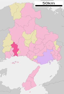
108:Location of Tatsuno in Hyōgo Prefecture
100:
72:
60:
236:210.87 km (81.42 sq mi)
223:Masanori Nishida (since November 2005)
718:The Tatsuno area was part of ancient
322:
312:
252:
244:
231:
218:
201:
189:
7:
1159:"たつの市/たつの市のあゆみ(歴史) たつののあけぼの(原始・古代)2"
375:of 74,414 in 31119 households and a
1723:List of mergers in Hyōgo Prefecture
1184:"○はりま風土記紀行○ – 古の播磨を訪ねて~たつの市 編 その2"
1145:"Tatsuno city official statistics"
25:
1747:Populated coastal places in Japan
1407:
1308:
1257:
1043:
1025:
1015:
1005:
995:
985:
975:
932:
911:
518:
504:
492:
125:
118:
102:
87:
77:
62:
1103:, composer of the folk melody "
126:
513:Taken at Hashisaki, Shingū-chō
1:
1270:Tatsuno City official website
742:gained supremacy during the
1234:Hyōgo population statistics
1083:Notable people from Tatsuno
486:), Azawara Pass, Iwami Pass
430:Higashimaru Shoyu Co., Ltd.
359:
1768:
1742:Cities in Hyōgo Prefecture
851:Hyogo Prefectural Assembly
780:. The town prospered as a
531:Neighboring Municipalities
1720:
1405:
1320:
828:
820:
641:—
597:Humid subtropical climate
353:
333:
309:
304:
300:
147:
113:
101:
73:
61:
52:
42:
1078:, National Historic Site
1072:, National Historic Site
1053:, sister city since 2015
889:(2010 National Census).
476:Japan National Route 179
38:
1031:National Route 250
1021:National Route 179
408:and used rock from the
257:350/km (910/sq mi)
1163:www.city.tatsuno.lg.jp
1125:Shadow of the Colossus
1011:National Route 29
730:, a stronghold of the
445:
433:
344:
167:34.85083°N 134.54528°E
1147:(in Japanese). Japan.
1107:" (The red dragonfly)
1051:Covington, Washington
1037:Sister city relations
1001:National Route 2
776:of the newly created
615:Historical population
439:
427:
414:Nomi no Sukune Shrine
393:Harima no Kuni Fudoki
342:
29:City in Kansai, Japan
1266:at Wikimedia Commons
1223:Tatsuno climate data
1188:www.harima-united.jp
1076:Shingū Miyauchi Site
254: • Density
770:, was installed as
616:
484:Prefectural Route 5
172:34.85083; 134.54528
163: /
879:commercial fishing
764:Tokugawa shogunate
470:Passes and Hills:
446:
434:
386:, but the name of
377:population density
345:
246: • Total
233: • Total
220: • Mayor
1729:
1728:
1403:
1402:
1331:
1262:Media related to
1058:Local attractions
991:Harima Expressway
981:San'yō Expressway
952:Higashi-Hashisaki
883:bedroom community
790:Meiji Restoration
711:
710:
343:Tatsuno CIty Hall
337:
336:
279:City hall address
139:Location in Japan
16:(Redirected from
1759:
1642:Kanzaki District
1411:
1343:
1325:
1314:Hyōgo Prefecture
1312:
1302:
1295:
1288:
1279:
1274:
1261:
1245:
1242:
1236:
1231:
1225:
1220:
1214:
1213:
1206:
1200:
1199:
1197:
1195:
1180:
1174:
1173:
1171:
1169:
1155:
1149:
1148:
1141:
1111:Shizuichi Tanaka
1048:
1047:
1029:
1028:
1019:
1018:
1009:
1008:
999:
998:
989:
988:
979:
978:
936:
921:San'yō Main Line
915:
832:
831:
830:
824:
823:
822:
736:Muromachi period
630:
625:
617:
522:
508:
496:
369:Hyōgo Prefecture
366:
365:
362:
356:
355:
296:
295:
293:Official website
178:
177:
175:
174:
173:
168:
164:
161:
160:
159:
156:
129:
128:
122:
106:
91:
81:
66:
47:
46:
45:
44:
32:
21:
1767:
1766:
1762:
1761:
1760:
1758:
1757:
1756:
1732:
1731:
1730:
1725:
1716:
1676:Mikata District
1664:Kawabe District
1589:
1468:
1445:
1412:
1399:
1332:
1316:
1306:
1272:
1254:
1249:
1248:
1243:
1239:
1232:
1228:
1221:
1217:
1208:
1207:
1203:
1193:
1191:
1182:
1181:
1177:
1167:
1165:
1157:
1156:
1152:
1143:
1142:
1138:
1133:
1095:Kazuya Maruyama
1085:
1060:
1042:
1039:
1026:
1016:
1006:
996:
986:
976:
972:
909:
904:
895:
867:
839:
826:
818:
760:Ikeda Toshitaka
728:Kinoyama Castle
720:Harima Province
716:
609:
593:
584:Ieshima Islands
533:
526:
523:
514:
512:
509:
500:
497:
450:Seto Inland Sea
422:
388:Tatsuno Station
363:
350:
291:
290:
171:
169:
165:
162:
157:
154:
152:
150:
149:
143:
142:
141:
140:
137:
136:
135:
134:
130:
109:
97:
96:
95:
94:
85:
84:
69:
57:
48:
40:
39:
37:
30:
23:
22:
15:
12:
11:
5:
1765:
1763:
1755:
1754:
1752:Tatsuno, Hyōgo
1749:
1744:
1734:
1733:
1727:
1726:
1721:
1718:
1717:
1715:
1714:
1713:
1712:
1702:
1701:
1700:
1690:
1689:
1688:
1683:
1673:
1672:
1671:
1661:
1660:
1659:
1654:
1649:
1639:
1638:
1637:
1632:
1622:
1621:
1620:
1610:
1609:
1608:
1597:
1595:
1591:
1590:
1588:
1587:
1582:
1577:
1572:
1570:Tamba-Sasayama
1567:
1562:
1557:
1552:
1547:
1542:
1537:
1532:
1527:
1522:
1517:
1512:
1507:
1502:
1497:
1492:
1487:
1482:
1476:
1474:
1470:
1469:
1467:
1466:
1461:
1455:
1453:
1451:Special cities
1447:
1446:
1444:
1443:
1438:
1433:
1428:
1422:
1420:
1414:
1413:
1406:
1404:
1401:
1400:
1398:
1397:
1392:
1387:
1382:
1377:
1372:
1367:
1362:
1357:
1351:
1349:
1340:
1334:
1333:
1321:
1318:
1317:
1307:
1305:
1304:
1297:
1290:
1282:
1276:
1275:
1267:
1264:Tatsuno, Hyōgo
1253:
1252:External links
1250:
1247:
1246:
1237:
1226:
1215:
1201:
1175:
1150:
1135:
1134:
1132:
1129:
1128:
1127:
1119:, director of
1114:
1108:
1098:
1092:
1084:
1081:
1080:
1079:
1073:
1067:
1064:Tatsuno Castle
1059:
1056:
1055:
1054:
1038:
1035:
1034:
1033:
1023:
1013:
1003:
993:
983:
971:
968:
967:
966:
930:
929:
908:
905:
903:
902:Transportation
900:
894:
891:
866:
863:
841:Tatsuno has a
838:
835:
778:Tatsuno Domain
768:Honda Masatomo
744:Sengoku period
715:
712:
709:
708:
705:
702:
698:
697:
694:
691:
687:
686:
683:
680:
676:
675:
672:
669:
665:
664:
661:
658:
654:
653:
650:
647:
643:
642:
639:
636:
632:
631:
626:
621:
608:
605:
595:Tatsuno has a
592:
589:
588:
587:
576:
562:
548:
532:
529:
528:
527:
524:
517:
515:
510:
503:
501:
498:
491:
488:
487:
468:
467:, Kurisu River
461:
460:(in Mitsu-chō)
421:
418:
398:Nomi no Sukune
335:
334:
331:
330:
325:
321:
320:
318:Cherry blossom
315:
311:
310:
307:
306:
302:
301:
298:
297:
288:
284:
283:
280:
276:
275:
265:
259:
258:
255:
251:
250:
247:
243:
242:
238:
237:
234:
230:
229:
225:
224:
221:
217:
216:
212:
211:
206:
200:
199:
194:
188:
187:
184:
180:
179:
145:
144:
138:
132:
131:
124:
123:
117:
116:
115:
114:
111:
110:
107:
99:
98:
92:
86:
82:
76:
75:
74:
71:
70:
67:
59:
58:
53:
50:
49:
35:
28:
24:
14:
13:
10:
9:
6:
4:
3:
2:
1764:
1753:
1750:
1748:
1745:
1743:
1740:
1739:
1737:
1724:
1719:
1711:
1708:
1707:
1706:
1705:Taka District
1703:
1699:
1696:
1695:
1694:
1693:Sayō District
1691:
1687:
1684:
1682:
1679:
1678:
1677:
1674:
1670:
1667:
1666:
1665:
1662:
1658:
1655:
1653:
1650:
1648:
1645:
1644:
1643:
1640:
1636:
1633:
1631:
1628:
1627:
1626:
1625:Kako District
1623:
1619:
1616:
1615:
1614:
1611:
1607:
1604:
1603:
1602:
1599:
1598:
1596:
1592:
1586:
1583:
1581:
1578:
1576:
1573:
1571:
1568:
1566:
1563:
1561:
1558:
1556:
1553:
1551:
1548:
1546:
1543:
1541:
1538:
1536:
1533:
1531:
1528:
1526:
1523:
1521:
1518:
1516:
1513:
1511:
1508:
1506:
1503:
1501:
1498:
1496:
1493:
1491:
1488:
1486:
1483:
1481:
1478:
1477:
1475:
1471:
1465:
1462:
1460:
1457:
1456:
1454:
1452:
1448:
1442:
1439:
1437:
1434:
1432:
1429:
1427:
1424:
1423:
1421:
1419:
1415:
1410:
1396:
1393:
1391:
1388:
1386:
1383:
1381:
1378:
1376:
1373:
1371:
1368:
1366:
1363:
1361:
1358:
1356:
1353:
1352:
1350:
1348:
1344:
1341:
1339:
1335:
1329:
1324:
1319:
1315:
1311:
1303:
1298:
1296:
1291:
1289:
1284:
1283:
1280:
1273:(in Japanese)
1271:
1268:
1265:
1260:
1256:
1255:
1251:
1241:
1238:
1235:
1230:
1227:
1224:
1219:
1216:
1211:
1205:
1202:
1190:(in Japanese)
1189:
1185:
1179:
1176:
1164:
1160:
1154:
1151:
1146:
1140:
1137:
1130:
1126:
1122:
1118:
1115:
1112:
1109:
1106:
1102:
1099:
1096:
1093:
1090:
1087:
1086:
1082:
1077:
1074:
1071:
1070:Yoshima Kofun
1068:
1065:
1062:
1061:
1057:
1052:
1046:
1041:
1040:
1036:
1032:
1024:
1022:
1014:
1012:
1004:
1002:
994:
992:
984:
982:
974:
973:
969:
965:
961:
957:
956:Harima-Shingū
953:
949:
946:
945:
944:
943:
939:
935:
928:
925:
924:
923:
922:
918:
914:
906:
901:
899:
892:
890:
888:
884:
880:
876:
872:
864:
862:
860:
859:Diet of Japan
856:
852:
848:
844:
843:mayor-council
836:
834:
816:
815:
810:
806:
802:
798:
793:
791:
787:
786:Wakisaka clan
783:
779:
775:
774:
769:
765:
761:
757:
754:in the early
753:
752:Himeji Domain
749:
745:
741:
737:
733:
732:Akamatsu clan
729:
725:
721:
713:
706:
703:
700:
699:
695:
692:
689:
688:
684:
681:
678:
677:
673:
670:
667:
666:
662:
659:
656:
655:
651:
648:
645:
644:
640:
637:
634:
633:
627:
622:
619:
618:
612:
606:
604:
602:
598:
590:
585:
581:
577:
575:
571:
567:
563:
561:
557:
553:
549:
547:
546:Sayō District
543:
539:
535:
534:
530:
521:
516:
507:
502:
495:
490:
485:
481:
477:
473:
469:
466:
462:
459:
455:
454:
453:
451:
443:
438:
431:
426:
419:
417:
415:
411:
407:
403:
399:
395:
394:
389:
385:
380:
378:
374:
370:
367:is a city in
361:
349:
341:
332:
329:
326:
319:
316:
303:
299:
294:
289:
281:
273:
269:
266:
264:
256:
248:
235:
222:
210:
207:
205:
198:
195:
193:
185:
176:
148:Coordinates:
121:
105:
90:
80:
65:
56:
51:
33:
27:
19:
1613:Ibo District
1601:Akō District
1574:
1244:地名 歴史 p. 238
1240:
1229:
1218:
1204:
1194:November 23,
1192:. Retrieved
1187:
1178:
1168:November 23,
1166:. Retrieved
1162:
1153:
1139:
1097:, politician
964:Nishi-Kurisu
931:
910:
896:
868:
840:
812:
809:Ibo District
794:
771:
758:. Following
750:, who ruled
740:Oda Nobunaga
717:
610:
607:Demographics
600:
594:
574:Ibo District
560:Akō District
447:
432:(soy sauce).
402:Ibo District
392:
381:
347:
346:
26:
1530:Minamiawaji
1441:Nishinomiya
1418:Core cities
1360:Higashinada
1117:Fumito Ueda
948:Hon-Tatsuno
942:Kishin Line
855:lower house
782:castle town
724:Izumo Kaidō
480:Futagi Pass
472:Aisaka Pass
456:Mountains:
360:Tatsuno-shi
328:Prunus mume
170: /
158:134°32′43″E
1736:Categories
1686:Shin'onsen
1464:Takarazuka
1131:References
1089:Akira Hori
847:unicameral
837:Government
807:(all from
756:Edo period
748:Ikeda clan
525:Iwami Hill
373:population
241:Population
215:Government
204:Prefecture
155:34°51′03″N
1594:Districts
1535:Nishiwaki
1520:Kawanishi
1431:Amagasaki
1101:Rofū Miki
893:Education
875:soy sauce
511:Ibo River
499:Mt. Ayabe
465:Ibo River
458:Mt. Ayabe
420:Geography
410:Ibo River
268:UTC+09:00
263:Time zone
1657:Kamikawa
1652:Ichikawa
1647:Fukusaki
1606:Kamigōri
1560:Takasago
1459:Kakogawa
1105:Akatombo
1091:, author
970:Highways
738:. After
599:(Köppen
556:Kamigōri
463:Rivers:
384:hiragana
1669:Inagawa
1580:Toyooka
1575:Tatsuno
1328:capital
938:JR West
927:Tatsuno
917:JR West
907:Railway
865:Economy
857:of the
797:Ibogawa
734:in the
714:History
591:Climate
578:South:
536:North:
348:Tatsuno
305:Symbols
287:Website
183:Country
133:Tatsuno
36:Tatsuno
18:Tatsuno
1630:Harima
1618:Taishi
1555:Sumoto
1495:Ashiya
1473:Cities
1436:Himeji
1426:Akashi
1395:Tarumi
1380:Nagata
960:Sembon
887:Himeji
805:Shingū
773:daimyō
704:80,541
693:83,207
682:83,045
674:+11.1%
671:81,167
660:73,058
649:70,720
638:72,414
580:Himeji
570:Taishi
566:Himeji
564:East:
550:West:
314:Flower
249:74,414
197:Kansai
192:Region
1635:Inami
1565:Tamba
1550:Shisō
1545:Sanda
1510:Kasai
1505:Itami
1500:Awaji
1490:Asago
1385:Nishi
1365:Hyōgo
1347:Wards
871:sōmen
814:kanji
801:Mitsu
707:−3.2%
701:2010
696:+0.2%
690:2000
685:+2.3%
679:1990
668:1980
663:+3.3%
657:1970
652:−2.3%
646:1960
635:1950
538:Shisō
406:Izumo
209:Hyōgo
186:Japan
1710:Taka
1698:Sayō
1681:Kami
1585:Yabu
1525:Miki
1515:Katō
1480:Aioi
1390:Suma
1375:Nada
1370:Kita
1355:Chūō
1338:Kobe
1323:Kobe
1196:2020
1170:2020
1123:and
873:and
829:たつの市
803:and
766:and
624:Pop.
620:Year
552:Aioi
542:Sayō
354:たつの市
324:Tree
228:Area
93:Seal
83:Flag
55:City
43:たつの市
1540:Ono
1485:Akō
1121:Ico
825:to
821:龍野市
601:Cfa
478:),
400:in
272:JST
1738::
1186:.
1161:.
1049:-
962:-
958:-
954:-
950:-
940:–
919:–
861:.
833:.
799:,
629:±%
572:,
568:;
558:,
554:;
544:,
540:;
357:,
1330:)
1326:(
1301:e
1294:t
1287:v
1198:.
1172:.
586:)
582:(
482:(
474:(
444:.
364:)
351:(
274:)
270:(
20:)
Text is available under the Creative Commons Attribution-ShareAlike License. Additional terms may apply.