706:
42:
331:
379:
After centuries of sheep-grazing the uplands of northern
Staffordshire are now to a large extent moorland, although even before this, the region was mostly unattractive to early settlers. It is noteworthy, as showing where the centres of these hundreds lay, that the meeting-places of the two northern
195:
1190–200). A large number of
Hundred names refer to hills or mounds. Some of these at least are very conspicuous hills, which afford a commanding view of the countryside for miles around. It seems likely that such sites were chosen as being remote, and where interference was most easily avoided.
227:
Totmonslow is one of the largest of the 5 hundreds of
Staffordshire, having an area of 169,788 acres (265 sq.miles) and the population in 1851 was 50,050. The hundred was divided into two divisions Totmanslow North and Totmanslow South by the Justices of the Peace, which an area of 100,234 and
962:
352:, a distance of 25 miles, and averaging from 10 to 15 miles in breadth. The River Dove forms its eastern boundary for nearly 30 miles, and separates it from
248:
923:
169:, England. The hundred is in the north-east of Staffordshire and is named after the hamlet of the same name, which is a half mile east of
967:
191:
meaning 'hill' or 'mound'. Other examples of this personal name are recorded from the 10th century onwards (e.g. Roberto
972:
323:, which have their principal sources in the Hundred, and here receive many small but rapid streams from the high, peaty
240:
158:
296:
208:
into counties, hundreds and tithings. From the beginning, Staffordshire was divided into the hundreds of
Totmonslow,
263:
Totmonslow, or
Totmanslow, is the north-eastern Hundred of Staffordshire, and contains the upland region called the
705:
844:
A topographical history of
Staffordshire, by William Pitt, pub J. Smith (Newcastle-under-Lyme), 1817; page 13
778:
746:
628:
592:
264:
726:
552:
472:
369:
365:
734:
682:
562:
522:
243:
declined from the 17th century, and most of their functions were extinguished with the establishment of
170:
41:
718:
434:
345:
610:
572:
361:
782:
794:
340:
209:
205:
766:
300:
252:
229:
956:
777:
Of the local government
Districts created in the 1974 re-organisation, nearly all of
320:
272:
166:
905:
History, Gazetteer and
Directory of Staffordshire by William White (1834), page 696
887:
History, Gazetteer and
Directory of Staffordshire by William White (1834), page 696
863:
817:
History, Gazetteer and
Directory of Staffordshire by William White (1834), page 744
730:
414:
312:
244:
330:
304:
790:
492:
462:
353:
316:
308:
280:
217:
938:
925:
835:
The English Hundred Names, by Olof Anderson, Lund (Sweden), 1934. Page xxxiii
786:
758:
750:
714:
664:
532:
444:
373:
349:
292:
288:
276:
233:
896:
The English Hundred Names, by Olof Anderson, Lund (Sweden), 1934. Page 144
826:
The English Hundred Names, by Olof Anderson, Lund (Sweden), 1934. Page 147
189:
798:
646:
582:
542:
512:
482:
381:
357:
324:
268:
247:
in 1867. In 1894 the Hundred was made obsolete with the establishment of
204:
The origin of the hundred dates from the division of his kingdom by King
762:
742:
722:
502:
360:
by the River Dane. In the 19th century it contained four market towns,
356:; and for about 10 miles at its northern extremity, it is divided from
221:
28:
384:
and Totmonslow) are in the extreme south of the respective hundreds.
213:
162:
914:
See www.staffordshire.gov.uk as compared with above list of parishes
876:
853:
Imperial Gazetteer of England and Wales, by John Marius Wilson, 1872
376:, and about 80 townships located in 10 chapelries and 30 parishes.
754:
738:
704:
424:
329:
793:, on the south-east by Offlow Hundred, on the south and west by
284:
781:
falls within Totmonslow Hundred, as does a substantial part of
338:
The Hundred has an irregular, oval figure, stretching from the
228:
69,554 acres respectively. Each had its own constable and
232:. The Petty Sessions for the South division were held at
267:, located at the southern end and foothills of the
138:
128:
121:
109:
101:
87:
77:
67:
57:
50:
21:
295:. The district contains the valleys of the rivers
271:, with some of the northern parts falling in the
173:. The hamlet was the seat of the hundred court.
181:The name of the place derives from Old English
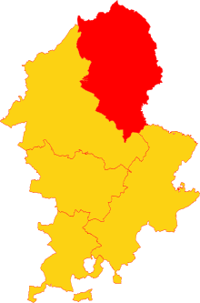
46:Totmonslow Hundred (red) shown in Staffordshire
862:The English Counties Delineated, Volume 2, by
789:. The Hundred is bounded on the north-east by
392:The hundred contained the following parishes:
963:States and territories disestablished in 1894
8:
40:
18:
394:
810:
120:
108:
100:
49:
279:in the north east, mostly forming the
769:(all in the ancient parish of Leek).
137:
127:
116:
86:
76:
66:
56:
7:
287:, while the far north consists of
14:
877:http://www.visionofbritain.org.uk
737:, extending into the parishes of
16:Hundred in Staffordshire, England
729:(all in the ancient parish of
275:National Park. It consists of
89: • Succeeded by
1:
797:, and on the north-west by
696:
686:
676:
668:
658:
650:
640:
632:
622:
614:
604:
596:
586:
576:
566:
556:
546:
536:
526:
516:
506:
496:
486:
476:
466:
456:
448:
438:
428:
418:
408:
989:
691:
681:
673:
663:
655:
645:
637:
627:
619:
609:
601:
591:
581:
571:
561:
551:
541:
531:
521:
511:
501:
491:
481:
471:
461:
453:
443:
433:
423:
413:
405:
968:Hundreds of Staffordshire
709:Hundreds of Staffordshire
148:
117:
97:
39:
34:
26:
200:History and organisation
779:Staffordshire Moorlands
713:The 10 chapelries were
265:Staffordshire Moorlands
785:including the town of
710:
335:
239:The importance of the
185:, a personal name and
79: • Abolished
27:Former subdivision of
875:See Staffordshire in
708:
523:Draycott in the Moors
333:
171:Draycott in the Moors
435:Bradley in the Moors
327:and rocky uplands.
69: • Created
973:Hamlets in Somerset
935: /
753:(Mayfield parish),
177:Derivation of names
134:Parishes (see text)
59: • Origin
783:East Staffordshire
711:
336:
334:Totmonslow Hundred
255:in Staffordshire.
140: • Units
63:Anglo-Saxon period
703:
702:
341:three shire stone
152:
151:
130: • Type
980:
950:
949:
947:
946:
945:
940:
939:52.950°N 2.000°W
936:
933:
932:
931:
928:
915:
912:
906:
903:
897:
894:
888:
885:
879:
873:
867:
866:, 1837. Page 138
860:
854:
851:
845:
842:
836:
833:
827:
824:
818:
815:
795:Pirehill Hundred
395:
291:which forms the
206:Alfred the Great
141:
131:
90:
80:
70:
60:
44:
19:
988:
987:
983:
982:
981:
979:
978:
977:
953:
952:
943:
941:
937:
934:
929:
926:
924:
922:
921:
919:
918:
913:
909:
904:
900:
895:
891:
886:
882:
874:
870:
861:
857:
852:
848:
843:
839:
834:
830:
825:
821:
816:
812:
807:
775:
767:Rushton Spencer
749:and Waterfall,
390:
348:, southward to
283:, and formerly
261:
253:Rural Districts
249:Urban Districts
202:
179:
139:
129:
88:
83:1894 (obsolete)
78:
68:
58:
45:
17:
12:
11:
5:
986:
984:
976:
975:
970:
965:
955:
954:
944:52.950; -2.000
917:
916:
907:
898:
889:
880:
868:
855:
846:
837:
828:
819:
809:
808:
806:
803:
774:
773:Reorganisation
771:
701:
700:
695:
689:
688:
685:
679:
678:
675:
671:
670:
667:
661:
660:
657:
653:
652:
649:
643:
642:
639:
635:
634:
631:
625:
624:
621:
617:
616:
613:
607:
606:
603:
599:
598:
595:
589:
588:
585:
579:
578:
575:
569:
568:
565:
559:
558:
555:
549:
548:
545:
539:
538:
535:
529:
528:
525:
519:
518:
515:
509:
508:
505:
499:
498:
495:
489:
488:
485:
479:
478:
475:
469:
468:
465:
459:
458:
455:
451:
450:
447:
441:
440:
437:
431:
430:
427:
421:
420:
417:
411:
410:
407:
403:
402:
399:
389:
386:
260:
257:
230:Petty Sessions
201:
198:
178:
175:
150:
149:
146:
145:
142:
136:
135:
132:
126:
125:
123:
119:
118:
115:
114:
111:
107:
106:
103:
99:
98:
95:
94:
91:
85:
84:
81:
75:
74:
71:
65:
64:
61:
55:
54:
52:
48:
47:
37:
36:
32:
31:
24:
23:
15:
13:
10:
9:
6:
4:
3:
2:
985:
974:
971:
969:
966:
964:
961:
960:
958:
951:
948:
911:
908:
902:
899:
893:
890:
884:
881:
878:
872:
869:
865:
859:
856:
850:
847:
841:
838:
832:
829:
823:
820:
814:
811:
804:
802:
800:
796:
792:
788:
784:
780:
772:
770:
768:
764:
760:
756:
752:
748:
744:
740:
736:
732:
728:
724:
720:
716:
707:
699:
694:
690:
684:
680:
672:
666:
662:
654:
648:
644:
636:
630:
626:
618:
612:
608:
600:
594:
590:
584:
580:
574:
570:
564:
560:
554:
550:
544:
540:
534:
530:
524:
520:
514:
510:
504:
500:
494:
490:
484:
480:
474:
470:
464:
460:
452:
446:
442:
436:
432:
426:
422:
416:
412:
404:
400:
397:
396:
393:
387:
385:
383:
377:
375:
371:
367:
363:
359:
355:
351:
347:
343:
342:
332:
328:
326:
322:
318:
314:
310:
306:
302:
298:
294:
290:
286:
282:
278:
274:
273:Peak District
270:
266:
258:
256:
254:
250:
246:
245:county courts
242:
237:
235:
231:
225:
223:
219:
215:
211:
207:
199:
197:
194:
190:
188:
184:
176:
174:
172:
168:
167:Staffordshire
164:
160:
156:
147:
143:
133:
124:
112:
105:obsolete area
104:
96:
92:
82:
72:
62:
53:
43:
38:
33:
30:
25:
20:
920:
910:
901:
892:
883:
871:
864:Thomas Moule
858:
849:
840:
831:
822:
813:
776:
731:Alstonefield
712:
697:
692:
415:Alstonefield
391:
378:
339:
337:
262:
238:
226:
203:
192:
186:
182:
180:
154:
153:
122:Subdivisions
73:10th century
942: /
957:Categories
805:References
791:Derbyshire
674:Waterfall
493:Cheddleton
463:Caverswall
401:Pop. 1831
380:hundreds (
354:Derbyshire
281:White Peak
218:Cuttleston
155:Totmonslow
110:Government
22:Totmonslow
787:Uttoxeter
759:Meerbrook
751:Butterton
715:Elkstones
665:Uttoxeter
602:Kingston
533:Ellastone
445:Bramshall
374:Uttoxeter
350:Uttoxeter
325:moorlands
293:Dark Peak
289:gritstone
277:limestone
259:Geography
234:Ellastone
799:Cheshire
747:Mayfield
647:Rocester
638:Oakover
629:Mayfield
593:Kingsley
583:Ipstones
543:Gratwich
513:Dilhorne
483:Checkley
454:Cauldon
406:Alveton
388:Parishes
382:Pirehill
358:Cheshire
344:, above
301:Manifold
269:Pennines
241:hundreds
210:Pirehill
144:Parishes
927:52°57′N
763:Onecote
743:Croxden
727:Longnor
723:Warslow
553:Grindon
503:Croxden
473:Cheadle
370:Cheadle
366:Longnor
321:Churnet
222:Seisdon
193:Tateman
183:Tatmonn
161:in the
159:hundred
113:Hundred
93:various
51:History
29:England
930:2°00′W
735:Calton
683:Wetton
656:Sheen
620:Leigh
615:10789
563:Horton
398:Parish
372:, and
319:, and
313:Blithe
214:Offlow
163:county
102:Status
755:Endon
739:Blore
719:Flash
698:46303
693:Total
669:4864
651:1040
633:1366
623:1038
597:1416
587:1325
537:1344
517:1510
497:1664
487:2247
477:4119
467:1207
425:Blore
419:4757
409:2401
346:Flash
305:Hamps
157:is a
765:and
725:and
687:497
677:531
659:366
611:Leek
605:368
577:210
573:Ilam
567:878
557:431
547:116
527:539
507:272
457:347
449:170
429:354
362:Leek
317:Dane
309:Tean
297:Dove
285:coal
251:and
220:and
187:hlaw
35:1894
733:),
641:62
439:75
165:of
959::
801:.
761:,
757:,
745:,
741:,
721:,
717:,
368:,
364:,
315:,
311:,
307:,
303:,
299:,
236:.
224:.
216:,
212:,
Text is available under the Creative Commons Attribution-ShareAlike License. Additional terms may apply.