54:
41:
61:
321:
The population were rural until the 1960s while suburban housing sprang up between the 1960s and the 1990s, making most of the population urban and expanding to this day. Housing development began in the central part of district where farmland once used to dominate its central areas and within the
313:
mountains lie to the northwest and the
Mesogeian plain to the north. Another mountain lies toward the northeast. Most of the area's streets take names from Greek mythology, and its main street, Poseidonos, forms a connection with the route running from Neo Faliro down toward the Glyfada boundary.
359:
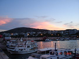
Since 2001 Varkiza has been hugely modernised. Varkiza just after the World War II was a small village for fishermen but today has developed to a small town for the rich with one of the best beaches in Attiki. In the summer the population triples as
Varkiza resort is right next to the top summer
314:
Forests cover partpart of the municipality, but much of the mountainous area is rocky and grassy. Varkiza has a widely known beach, which has tennis courts, parkland and fields, restaurants, taverns, complexes and other amenities. The
283:
384:
240:
160:
148:
389:
82:
369:
210:
53:
350:
Varkiza has one school (dimotiko), banks, a church, restaurants, bars, taverns, a post office and a couple of squares (
230:
326:. Later, Varkiza became part of the Athens urban area, and in the 1960s, the connecting highway had two lanes added.
136:
299:
263:
218:
153:
189:
199:
271:
335:
295:
124:
339:
129:
259:
378:
323:
315:
303:
287:
141:
97:
84:
180:
40:
310:
352:
342:. It was signed at the Kanelopoulos Mansion, which is located at Vari.
291:
279:
267:
206:
185:
117:
278:). It lies approximately 2 km south of Vari, 22 km S of
165:
294:, and south of the Hymettus Ring. The locality is linked with
318:
sporadically covers the farmlands and moves west of
Varkiza.
239:
229:
217:
196:
179:
171:
159:
147:
135:
123:
113:
21:
360:clubs which are located on the "Glyfada strip".
8:
338:was signed in 1945 in an attempt to end the
284:Eleftherios Venizelos International Airport
18:
216:
178:
170:
112:
77:
46:
37:
258:(Αλίανθος), is a town and a suburb of
238:
228:
195:
158:
146:
134:
122:
7:
262:forming part of the municipality of
14:
254:(Greek: Βάρκιζα), also formerly
59:
52:
39:
385:Populated places in East Attica
290:(numbers 6 and 62), NW of Cape
60:
1:
370:List of communities of Attica
406:
78:
47:
38:
31:
25:
282:city centre, SW of the
390:Vari-Voula-Vouliagmeni
264:Vari-Voula-Vouliagmeni
154:Vari-Voula-Vouliagmeni
198: • Summer (
175:5 m (16 ft)
125:Administrative region
241:Vehicle registration
16:Settlement in Greece
94: /
336:Treaty of Varkiza
296:Poseidonos Avenue
249:
248:
98:37.817°N 23.800°E
397:
302:), just east of
203:
109:
108:
106:
105:
104:
99:
95:
92:
91:
90:
87:
63:
62:
56:
43:
19:
405:
404:
400:
399:
398:
396:
395:
394:
375:
374:
366:
348:
340:Greek Civil War
332:
225:
197:
102:
100:
96:
93:
88:
85:
83:
81:
80:
74:
73:
72:
71:
70:
69:
68:
64:
34:
27:
24:
17:
12:
11:
5:
403:
401:
393:
392:
387:
377:
376:
373:
372:
365:
362:
347:
344:
331:
328:
272:Megalo Daktylo
260:greater Athens
247:
246:
243:
237:
236:
233:
227:
226:
223:
221:
215:
214:
204:
194:
193:
183:
177:
176:
173:
169:
168:
163:
161:Municipal unit
157:
156:
151:
145:
144:
139:
133:
132:
127:
121:
120:
115:
111:
110:
103:37.817; 23.800
76:
75:
66:
65:
58:
57:
51:
50:
49:
48:
45:
44:
36:
35:
32:
29:
28:
22:
15:
13:
10:
9:
6:
4:
3:
2:
402:
391:
388:
386:
383:
382:
380:
371:
368:
367:
363:
361:
357:
355:
354:
345:
343:
341:
337:
329:
327:
325:
319:
317:
312:
307:
305:
301:
297:
293:
289:
285:
281:
277:
273:
269:
265:
261:
257:
253:
244:
242:
234:
232:
222:
220:
212:
208:
205:
201:
191:
187:
184:
182:
174:
167:
164:
162:
155:
152:
150:
143:
140:
138:
137:Regional unit
131:
128:
126:
119:
116:
107:
79:Coordinates:
55:
42:
30:
20:
358:
351:
349:
333:
324:Saronic Gulf
320:
316:urban sprawl
308:
276:Large Finger
275:
266:in southern
255:
251:
250:
231:Area code(s)
149:Municipality
304:Vouliagmeni
288:Attiki Odos
219:Postal code
142:East Attica
101: /
379:Categories
33:Settlement
256:Alianthos
181:Time zone
172:Elevation
364:See also
353:plateies
311:Hymettus
286:and the
330:History
270:of the
252:Varkiza
114:Country
89:23°48′E
86:37°49′N
67:Varkiza
26:Βάρκιζα
23:Varkiza
292:Sounio
280:Athens
268:Attica
224:166 72
130:Attica
118:Greece
346:Other
300:GR-91
207:UTC+3
186:UTC+2
334:The
309:The
211:EEST
166:Vari
356:).
235:210
200:DST
190:EET
381::
306:.
298:(
274:(
245:Z
213:)
209:(
202:)
192:)
188:(
Text is available under the Creative Commons Attribution-ShareAlike License. Additional terms may apply.