413:
308:
296:
324:
43:
363:
336:
392:
245:
269:
284:
257:
378:
348:
31:
599:
51:
412:
419:
672:
516:
307:
244:
643:
560:
667:
323:
295:
268:
35:
662:
335:
677:
682:
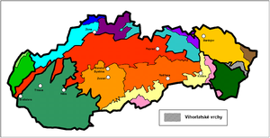
436:
172:
283:
256:
362:
636:
546:
496:
391:
347:
520:
42:
629:
423:
377:
187:
441:
368:
353:
314:
207:
199:
179:
609:
168:
113:
230:
164:
97:
233:
on June 28, 2007, because of its comprehensive and undisturbed ecological patterns and processes.
144:
117:
81:
70:
195:
613:
109:
529:
219:
124:
62:
383:
30:
539:
50:
656:
550:
533:
525:
397:
598:
159:
The Slovak part is 55 km long, up to 11 km broad and from 400 to 1,076
275:
575:
562:
606:
89:
17:
93:
226:
222:
160:
49:
41:
29:
510:
203:
202:
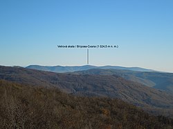
highlands in the north. The highest peak is
Vihorlat at 1,076 m
250:
Vihorlat (1,076 m), the highest mountain of
Vihorlat Mountains
617:
486:] (in Hungarian). Budapest: Akadémiai. p. 694.
422:
Panorama of
Vihorlat Mountains (Vihorlatské vrchy) and
171:. The middle part of the mountains is protected by the
534:Photo gallery Inversion – Vihorlat, Sninský kameň
151:derives from Slovak as an intermediate language.
225:forest in Vihorlat Mountains, was proclaimed by
637:
463:Martinka, Jozef (1940). "O názve Vihorlátu".
8:
206:. The largest lake in the mountain range is
34:Location of Vihorlat in Slovakia within the
484:Etymological Dictionary of Geographic Names
131:) - a burned forest with a grouping suffix
673:Mountain ranges of the Eastern Carpathians
644:
630:
458:
456:
143:- a mountain with many burned places. The
467:(in Slovak) (5–6). Matica slovencká: 142.
88:is a volcanic mountain range in eastern
452:
240:
540:Distant sights from Vihorlat Mountains
536:(photos of Vihorlat and Sninský kameň)
274:Vihorlat in winter, in the background
27:Mountain range in Slovakia and Ukraine
96:. A part of the range is listed as a
36:geomorphological division of Slovakia
7:
595:
593:
289:Winter in Vihorlat (left peak Kyjov)
542:on the portal Na obzore (in Slovak)
480:Földrajzi nevek etimológiai szótára
210:, which is situated at 618 m AMSL.
616:. You can help Knowledge (XXG) by
262:Pylon on top of Vihorlat with rime
169:Inner Eastern Carpathian Mountains
25:
517:Protected Landscape Area Vihorlat
511:Chránená krajinná oblasť Vihorlat
437:Vihorlat Protected Landscape Area
329:Sninský kameň in winter at sunset
186:) in the south and the west. The
173:Vihorlat Protected Landscape Area
668:World Heritage Sites in Slovakia
597:
411:
390:
376:
361:
346:
334:
322:
306:
294:
282:
267:
255:
243:
194:) separates Vihorlat from the
155:Vihorlat Mountains in Slovakia
1:
178:Vihorlat is bordered by the
84:: Vihorlát) or colloquially
663:Mountain ranges of Slovakia
530:Photo gallery Sninský kameň
188:Beskidian Southern Piedmont
699:
678:Mountain ranges of Ukraine
592:
549:(in Czech). Archived from
74:
683:Slovakia geography stubs
163:high. It belongs to the
116:suggested the origin in
341:Sninský kameň in autumn
301:Sninský kameň (1,006 m)
184:Východoslovenská nížina
526:Photo gallery Vihorlat
356:and peak Sninský kameň
180:Eastern Slovak Lowland
66:
55:
47:
46:Vihorlat during winter
39:
547:"Fotografie Vihorlat"
53:
45:
33:
478:Kiss, Lajos (1978).
572: /
231:World Heritage Site
218:Kyjovský prales, a
214:World Heritage Site
200:Laborecká vrchovina
192:Beskydské predhorie
165:Vihorlat-Gutin Area
98:World Heritage Site
317:from Sninský kameň
59:Vihorlat Mountains
56:
48:
40:
625:
624:
576:48.917°N 22.167°E
424:Zemplínska šírava
67:Vihorlatské vrchy
16:(Redirected from
690:
646:
639:
632:
601:
594:
587:
586:
584:
583:
582:
577:
573:
570:
569:
568:
565:
554:
499:
494:
488:
487:
475:
469:
468:
460:
415:
394:
380:
365:
350:
338:
326:
310:
298:
286:
271:
259:
247:
76:
21:
698:
697:
693:
692:
691:
689:
688:
687:
653:
652:
651:
650:
590:
580:
578:
574:
571:
566:
563:
561:
559:
558:
545:
521:Slovakia.travel
507:
502:
495:
491:
477:
476:
472:
462:
461:
454:
450:
433:
428:
427:
426:
421:
416:
407:
400:
395:
386:
381:
372:
366:
357:
351:
342:
339:
330:
327:
318:
311:
302:
299:
290:
287:
278:
272:
263:
260:
251:
248:
239:
216:
157:
108:The name is of
106:
28:
23:
22:
15:
12:
11:
5:
696:
694:
686:
685:
680:
675:
670:
665:
655:
654:
649:
648:
641:
634:
626:
623:
622:
602:
581:48.917; 22.167
556:
555:
553:on 2009-10-26.
543:
537:
523:
514:
506:
505:External links
503:
501:
500:
489:
470:
451:
449:
446:
445:
444:
439:
432:
429:
418:
417:
410:
409:
408:
406:
403:
402:
401:
396:
389:
387:
384:Jasenov Castle
382:
375:
373:
367:
360:
358:
352:
345:
343:
340:
333:
331:
328:
321:
319:
312:
305:
303:
300:
293:
291:
288:
281:
279:
273:
266:
264:
261:
254:
252:
249:
242:
238:
235:
215:
212:
198:mountains and
196:Bukovské vrchy
156:
153:
121:vyharj / vyhar
114:Jozef Martinka
105:
102:
54:Ukrainian part
26:
24:
14:
13:
10:
9:
6:
4:
3:
2:
695:
684:
681:
679:
676:
674:
671:
669:
666:
664:
661:
660:
658:
647:
642:
640:
635:
633:
628:
627:
621:
619:
615:
612:article is a
611:
608:
603:
600:
596:
591:
588:
585:
552:
548:
544:
541:
538:
535:
531:
527:
524:
522:
518:
515:
512:
509:
508:
504:
498:
493:
490:
485:
481:
474:
471:
466:
465:Slovenská reč
459:
457:
453:
447:
443:
440:
438:
435:
434:
430:
425:
420:
414:
404:
399:
398:Brekov Castle
393:
388:
385:
379:
374:
370:
364:
359:
355:
349:
344:
337:
332:
325:
320:
316:
309:
304:
297:
292:
285:
280:
277:
270:
265:
258:
253:
246:
241:
236:
234:
232:
228:
224:
221:
213:
211:
209:
205:
201:
197:
193:
189:
185:
181:
176:
174:
170:
167:group of the
166:
162:
154:
152:
150:
146:
142:
138:
134:
130:
126:
122:
119:
115:
111:
103:
101:
99:
95:
91:
87:
83:
80:
72:
68:
64:
60:
52:
44:
37:
32:
19:
618:expanding it
604:
589:
557:
551:the original
492:
483:
479:
473:
464:
217:
191:
183:
177:
158:
148:
140:
136:
132:
128:
120:
107:
92:and western
85:
78:
58:
57:
579: /
513:(in Slovak)
276:High Tatras
657:Categories
497:unesco.org
448:References
442:Morské oko
369:Morské oko
354:Morské oko
315:Morské oko
208:Morské oko
79:Vyhorliat,
610:geography
145:Hungarian
141:Vyhorljať
137:Vygarljať
118:Ruthenian
104:Etymology
82:Hungarian
71:Ukrainian
38:(in gray)
431:See also
405:Panorama
313:View of
229:to be a
220:primeval
149:Vihorlát
112:origin.
90:Slovakia
86:Vihorlat
75:Вигорлат
18:Vihorlat
567:22°10′E
564:48°55′N
237:Gallery
94:Ukraine
607:Slovak
371:in May
227:UNESCO
125:Slovak
110:Slavic
63:Slovak
605:This
482:[
223:beech
147:name
129:výhor
614:stub
204:AMSL
519:at
133:-ať
659::
532:,
528:,
455:^
175:.
139:,
135:.
127::
100:.
77:,
73::
69:;
65::
645:e
638:t
631:v
620:.
190:(
182:(
161:m
123:(
61:(
20:)
Text is available under the Creative Commons Attribution-ShareAlike License. Additional terms may apply.