277:
231:
42:
217:
254:
209:
262:
526:
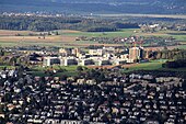
located on the eastern Käferberg slope respectively on western part of the Hönggerberg hill (officially the campus is named "ETH Hönggerberg", too). ETH Zurich declares it as vision of a university campus and a "City district of brainstorming culture" which will transform the ETH site into a place
527:
with greater quality of life through a variety of measures. It is also declared as a platform that will make it possible for the ETH Zurich to realize future projects that are based on the pioneering and symbolic development of future living and cognitive space.
408:) is about 200 metres (656 ft) above the Limmat Valley. From northwest to southeast, Käferberg-Waidberg is part of a chain of peaks respectively mountains: Hönggerberg (541 metres or 1,775 feet), Käferberg-Waidberg, Zürichberg (676 metres or 2,218 feet),
276:
505:
which is now a popular pic-nic site, too. The area is used for recreation and sport on a clearing not far from the ETH-Hönggerberg. There was a project to renew the
Waidbad as a site of wellness, to integrate the area in a so-called "forest
872:
596:
In
September 2014 a study was published for the construction of a new rail tunnel and underground station serving the ETH Hönggerberg "Science City". The new tunnel would run directly between Hardbrücke and
1132:
1127:
1040:
926:
230:
41:
1122:
586:
96:
760:
724:
601:
stations, as opposed to the indirect route via the existing Käferberg Tunnel and
Oerlikon station that is currently used by service S6.
590:
641:, the forest area on Käferberg owned by the citizens was sold in 1934 to the city of Zürich as well as the other areas of the former
1112:
682:
667:
919:
547:
1117:
1005:
598:
645:
located there. Even today, there are large, contiguous agricultural land in the immediate neighborhood of the "Science City".
450:. The upper area of the mountain is mostly woodland and a popular recreational area with picnic sites, in addition there are
802:
216:
89:
912:
618:
544:
965:
960:
558:
line 46 (City–Rütihof) and bus line 69 (Milchbuck–Hönggerberg) run up to different parts of the mountain area.
253:
296:
208:
1030:
1010:
659:
431:
990:
551:
48:
637:
which is since 1962/3 the care center Käferberg. As part of the incorporation of the former municipality
475:
261:
220:
350:
224:
845:
198:
510:" including indoor baths, sauna, cafeteria, complete infrastructure and attractive outdoor grounds.
1035:
950:
562:
170:
970:
678:
663:
337:) and Waidberg (mountain of meadows) are the peaks of a longish mountain in the north of the
566:
463:
1015:
773:
313:
536:
1025:
985:
442:
It is a picturesque location, and the upper southwestern side is also the location of
1106:
1091:
1060:
1000:
980:
455:
447:
386:
378:
370:
281:
266:
194:
1045:
642:
634:
390:
326:
149:
285:
182:
809:
257:
Waidberg (to the left) and Käferberg summits as seen from Zürichsee (Lake Zürich)
955:
555:
471:
414:
374:
202:
753:
747:
741:
717:
711:
705:
1050:
1020:
975:
904:
523:
443:
358:
301:
246:
234:
174:
60:
111:
98:
1086:
1076:
1055:
582:
459:
409:
346:
290:
270:
242:
190:
56:
936:
178:
136:
803:"ETH Zürich, Professor Miroslav Sik: Waidbad Spa in Zürich-Waidberg (p.4)"
787:
995:
638:
578:
574:
570:
494:
342:
238:
52:
17:
610:
565:
runs under a shoulder of the hill, carrying trains, including those of
497:
are situated within the woodland at
Waidberg summit, nearby the former
467:
398:
394:
309:
519:
451:
338:
79:
64:
625:
of the city of Zürich. Since 1907, the houses "Zur Waid" served as
423:
305:
275:
260:
252:
229:
215:
207:
186:
833:
888:
487:
478:
are typical for the southern and northern upper parts, too. The
908:
454:
routes heading from
Bucheggplatz to the canton of Aargau and a
507:
880:
873:
Official website of the city of Zürich: Perimeter (Käferberg)
896:
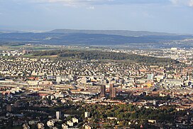
621:, in the 17th century the area was part of the so-called
654:
Hochbaudepartement der Stadt Zürich, Amt für Städtebau:
539:
754:
482:
is located in the south nearby the city hospital Waid (
748:
742:
393:. In the north, the region is bordered by the Glatt,
381:
1069:
943:
148:
143:
132:
127:
88:
78:
73:
34:
458:. Rarely to find in the urban area of Zürich are
341:Valley. It is located in the Zürich districts of
377:. In the east, Käferberg is bordered by a small
493:Another restaurant, a Tennis club and a small
920:
8:
851:(in German). ADF Innovation Consulting. 2014
677:. Wibichinga Verlag, Zürich Wipkingen 2006,
656:Affoltern, Oerlikon, Schwamendingen, Seebach
173:of a wooded range of hills overlooking the
1133:Mountains of Switzerland under 1000 metres
927:
913:
905:
31:
629:, a small public hospital. The so-called
389:, leading from the city of Zürich to the
718:
212:"Downtown" Zürich as seen from Käferberg
712:
706:
694:
446:overlooking the city of Zürich and the
169:(el. 601 metres or 1,972 feet) are the
658:. Baukultur in Zürich, Band I, Verlag
561:The 2,119 metres (6,952 ft) long
369:heading on the northern border of the
55:and Käferberg-Waidberg, as seen from
7:
761:Historical Dictionary of Switzerland
725:Historical Dictionary of Switzerland
165:(el. 571 metres or 1,873 feet) and
788:Wärmebad Käferberg on badi-info.ch
25:
1128:Mountains of the canton of Zürich
846:"Tunnelbahnhof für «Science City"
675:Wipkingen - Vom Dorf zum Quartier
673:Martin Bürlimann, Kurt Gammeter:
633:was rebuilt in 1918 as an urban
474:on the southwestern upper hill.
40:
554:–Triemli, bus line 38 (Höngg),
430:(778 metres or 2,552 feet) and
774:Zürich Vitaparcours: Käferberg
385:(476 metres or 1,562 feet) at
316:in the foreground to the left.
1:
1123:Tourist attractions in Zürich
609:In addition to a total of 15
434:(873 metres or 2,864 feet).
422:(715 metres or 2,346 feet),
418:(696 metres or 2,283 feet),
412:(701 metres or 2,300 feet),
27:Summits of a wooded mountain
1041:University Botanical Garden
617:(palisades) outside of the
1149:
84:601 m (1,972 ft)
514:ETH Zurich "Science City"
223:on northern Käferberg in
67:airport in the background
39:
1113:Mountains of Switzerland
897:Quartierverein Wipkingen
881:Quartierverein Affoltern
619:Fortifications of Zürich
1031:Strandbad Tiefenbrunnen
834:ETH Zurich Science City
501:(public open air bath)
280:View from on the upper
537:tram numbers 11 and 15
317:
273:
258:
250:
227:
213:
935:Parks and forests in
279:
264:
256:
233:
219:
211:
1006:Old Botanical Garden
889:Quartierverein Höngg
738:Affoltern bei Zürich
660:Neue Zürcher Zeitung
623:third fortifications
265:Käferberg and upper
112:47.40533°N 8.52021°E
1118:Geography of Zürich
1036:Sukkulentensammlung
991:Louis-Häfliger-Park
404:Its highest point (
335:mountain of beetles
108: /
971:Gustav-Ammann-Park
518:Science City is a
480:Wärmebad Käferberg
438:Points of interest
365:, and the western
318:
312:to the right, the
302:Zimmerberg plateau
284:at Zürich towards
274:
259:
251:
228:
214:
74:Highest point
63:(to the left) and
35:Käferberg-Waidberg
1100:
1099:
300:to the left, the
249:in the background
225:Affoltern quarter
199:Zürcher Unterland
193:, as well as the
160:
159:
117:47.40533; 8.52021
68:
16:(Redirected from
1140:
929:
922:
915:
906:
901:
893:
885:
877:
861:
860:
858:
856:
850:
842:
836:
831:
825:
824:
822:
820:
814:
808:. Archived from
807:
799:
793:
792:
785:
779:
778:
771:
765:
756:
750:
744:
735:
729:
720:
714:
708:
699:
563:Käferberg Tunnel
464:Salvia pratensis
152:
123:
122:
120:
119:
118:
113:
109:
106:
105:
104:
101:
46:
44:
32:
21:
1148:
1147:
1143:
1142:
1141:
1139:
1138:
1137:
1103:
1102:
1101:
1096:
1065:
939:
933:
899:
891:
883:
875:
869:
864:
854:
852:
848:
844:
843:
839:
832:
828:
818:
816:
812:
805:
801:
800:
796:
790:
786:
782:
776:
772:
768:
736:
732:
700:
696:
692:
662:, Zürich 2003,
651:
607:
543:as well as the
533:
516:
440:
426:mountain pass,
359:ETH-Hönggerberg
323:
314:Swissmill Tower
269:, as seen from
241:, as seen from
235:ETH Hönggerberg
150:
116:
114:
110:
107:
102:
99:
97:
95:
94:
69:
28:
23:
22:
15:
12:
11:
5:
1146:
1144:
1136:
1135:
1130:
1125:
1120:
1115:
1105:
1104:
1098:
1097:
1095:
1094:
1089:
1084:
1079:
1073:
1071:
1067:
1066:
1064:
1063:
1058:
1053:
1048:
1043:
1038:
1033:
1028:
1026:Schanzengraben
1023:
1018:
1013:
1008:
1003:
998:
993:
988:
983:
978:
973:
968:
963:
958:
953:
947:
945:
941:
940:
934:
932:
931:
924:
917:
909:
903:
902:
894:
886:
878:
868:
867:External links
865:
863:
862:
837:
826:
815:on 6 July 2011
794:
780:
766:
758:in the online
730:
722:in the online
693:
691:
688:
687:
686:
671:
650:
647:
606:
603:
532:
531:Transportation
529:
515:
512:
476:Schrebergärten
439:
436:
322:
319:
221:Schrebergärten
158:
157:
154:
146:
145:
141:
140:
134:
130:
129:
125:
124:
92:
86:
85:
82:
76:
75:
71:
70:
45:
37:
36:
26:
24:
14:
13:
10:
9:
6:
4:
3:
2:
1145:
1134:
1131:
1129:
1126:
1124:
1121:
1119:
1116:
1114:
1111:
1110:
1108:
1093:
1090:
1088:
1085:
1083:
1080:
1078:
1075:
1074:
1072:
1068:
1062:
1059:
1057:
1054:
1052:
1049:
1047:
1044:
1042:
1039:
1037:
1034:
1032:
1029:
1027:
1024:
1022:
1019:
1017:
1014:
1012:
1009:
1007:
1004:
1002:
1001:Oerliker Park
999:
997:
994:
992:
989:
987:
984:
982:
981:Leutschenpark
979:
977:
974:
972:
969:
967:
964:
962:
959:
957:
954:
952:
949:
948:
946:
942:
938:
930:
925:
923:
918:
916:
911:
910:
907:
898:
895:
890:
887:
882:
879:
874:
871:
870:
866:
847:
841:
838:
835:
830:
827:
811:
804:
798:
795:
789:
784:
781:
775:
770:
767:
763:
762:
757:
751:
745:
739:
734:
731:
727:
726:
721:
715:
709:
703:
698:
695:
689:
684:
683:3-9523149-0-0
680:
676:
672:
669:
668:3-03823-034-0
665:
661:
657:
653:
652:
648:
646:
644:
640:
636:
632:
628:
624:
620:
616:
612:
604:
602:
600:
594:
592:
588:
584:
580:
576:
572:
568:
567:S-Bahn Zürich
564:
559:
557:
553:
549:
546:
542:
538:
530:
528:
525:
521:
513:
511:
509:
504:
500:
496:
491:
489:
485:
481:
477:
473:
469:
465:
461:
457:
456:Vita Parcours
453:
449:
448:Limmat Valley
445:
437:
435:
433:
429:
425:
421:
417:
416:
411:
407:
402:
400:
396:
392:
388:
384:
380:
379:mountain pass
376:
372:
371:Limmat valley
368:
364:
360:
356:
352:
348:
344:
340:
336:
332:
328:
320:
315:
311:
307:
303:
299:
298:
293:
292:
287:
283:
282:Limmat Valley
278:
272:
268:
267:Limmat Valley
263:
255:
248:
244:
240:
236:
232:
226:
222:
218:
210:
206:
204:
200:
196:
195:Limmat Valley
192:
188:
184:
180:
176:
172:
168:
164:
155:
153:
151:Easiest route
147:
142:
139:, Switzerland
138:
135:
131:
126:
121:
93:
91:
87:
83:
81:
77:
72:
66:
62:
58:
54:
50:
43:
38:
33:
30:
19:
1081:
1046:Villa Tobler
853:. Retrieved
840:
829:
817:. Retrieved
810:the original
797:
783:
769:
759:
737:
733:
723:
701:
697:
674:
655:
643:urban forest
635:nursing home
630:
626:
622:
614:
608:
595:
560:
540:
534:
517:
502:
498:
492:
483:
479:
472:Sand Lizards
441:
432:Pfannenstiel
427:
419:
413:
405:
403:
391:Glatt valley
382:
366:
363:Science City
362:
355:Bucheggplatz
354:
334:
330:
327:Swiss German
324:
297:Pfannenstiel
295:
289:
166:
162:
161:
156:Tram and bus
29:
1011:Quaianlagen
966:Chinagarten
961:Bürkliplatz
956:Belvoirpark
900:(in German)
892:(in German)
884:(in German)
876:(in German)
791:(in German)
777:(in German)
627:Krankenheim
556:trolley bus
545:bus line 80
444:restaurants
367:Hönggerberg
361:, known as
325:Käferberg (
310:Sihl Valley
237:and Zürich-
203:Switzerland
115: /
90:Coordinates
1107:Categories
1092:Zürichberg
1061:Zürichhorn
1051:Wahlenpark
1021:Rieterpark
1016:Platzspitz
976:Irchelpark
690:References
649:Literature
599:Regensdorf
593:stations.
587:Hardbrücke
585:, between
552:Altstetten
541:Frankental
524:ETH Zurich
484:Waidspital
387:Zürichberg
353:, between
331:Chäferberg
189:chain and
175:inner city
100:47°24′19″N
49:Altstetten
1087:Uetliberg
1082:Käferberg
1077:Adlisberg
1056:Werdinsel
986:Lindenhof
951:Arboretum
490:inhabit.
460:Centaurea
410:Adlisberg
401:valleys.
383:Milchbuck
351:Affoltern
347:Wipkingen
321:Geography
291:Adlisberg
286:Zürichsee
271:Felsenegg
243:Uetliberg
191:Uetliberg
183:Zürichsee
163:Käferberg
128:Geography
103:8°31′13″E
80:Elevation
57:Uetliberg
996:MFO-Park
855:16 April
615:Letzinen
611:bastions
591:Oerlikon
548:Oerlikon
495:TV tower
486:) and a
428:Guldenen
420:Wassberg
415:Öschbrig
406:Waidberg
375:Würenlos
333:meaning
197:and the
167:Waidberg
144:Climbing
133:Location
18:Waidberg
1070:Forests
819:16 June
755:Italian
719:Italian
631:Waidgut
605:History
522:of the
503:Waidbad
499:Freibad
468:Knautia
247:Rümlang
171:summits
61:Rümlang
47:Zürich-
937:Zürich
749:French
743:German
713:French
707:German
681:
666:
569:lines
520:campus
452:hiking
339:Limmat
179:Zürich
137:Zürich
65:Kloten
944:Parks
849:(PDF)
813:(PDF)
806:(PDF)
702:Höngg
639:Höngg
424:Forch
343:Höngg
306:Albis
239:Höngg
187:Albis
53:Höngg
857:2015
821:2009
752:and
740:in
716:and
704:in
679:ISBN
664:ISBN
613:and
589:and
581:and
535:The
488:Deer
470:and
399:Furt
397:and
395:Wehn
357:and
349:and
308:and
294:and
51:and
583:S16
508:spa
373:to
205:.
201:in
177:of
1109::
746:,
710:,
579:S7
577:,
575:S6
573:,
571:S5
466:,
462:,
345:,
329::
304:,
288::
245:,
185:,
181:,
59:,
928:e
921:t
914:v
859:.
823:.
764:.
728:.
685:.
670:.
550:–
20:)
Text is available under the Creative Commons Attribution-ShareAlike License. Additional terms may apply.