68:
2558:
83:
56:
925:, there were 2,801 people, 836 households, and 638 families in the county. The population density was 1.4 inhabitants per square mile (0.54/km). There were 987 housing units at an average density of 0.5 per square mile (0.19/km). The racial makeup of the county was 74.9% American Indian, 21.8% white, 0.2% black or African American, 0.1% Asian, 0.1% from other races, and 3.0% from two or more races. Those of Hispanic or Latino origin made up 3.1% of the population.
138:
3766:
155:
419:
agriculture and cattle. The terrain slopes to the south and the east; its highest point (except for the isolated
Thunder Butte, at 2,733') is near its NW corner at 2,582 ft (787 m) ASL. The county has a total area of 1,971 square miles (5,100 km), of which 1,961 square miles (5,080 km) is land and 9.3 square miles (24 km) (0.5%) is water. Almost the entire county lies within the
2419:
2436:
2411:
255:
2394:
528:
578:
568:
558:
548:
538:
928:
Of the 836 households, 53.7% had children under the age of 18 living with them, 39.0% were married couples living together, 29.3% had a female householder with no husband present, 23.7% were non-families, and 20.9% of all households were made up of individuals. The average household size was 3.35 and
932:
The median income for a household in the county was $ 27,578 and the median income for a family was $ 22,857. Males had a median income of $ 28,954 versus $ 24,327 for females. The per capita income for the county was $ 11,069. About 41.9% of families and 46.0% of the population were below the
418:
flows eastward through the upper portion of the county, and Cherry Creek flows southeastward through the lower portion, draining the area into the
Cheyenne River. The terrain is composed of semi-arid rolling hills interrupted by buttes and carved by drainages and gullies, partly devoted to
1042:
in 2008 have topped sixty percent for either major party in the past six decades. Donald Trump won 48% of the vote in 2016, being the county or equivalent he won with the highest percentage of Native
Americans. Joe Biden won 53% of the vote in 2020.
1911:
2044:
381:
counties. The present
Ziebach County was created by the SD Legislature on February 1, 1911, and was fully organized by April 22. The 1911 Ziebach County encompassed parts of the former counties of Schnasse,
402:. Early in the 20th Century cattle were raised in substantial numbers, but when the railroad bypassed the area this industry declined. Limited homesteading also occurred on the more fertile lands.
2803:
390:, a political figure in the Dakota Territory during the territorial period from 1861 to 1889. Previously the area had been used by trappers and in 1907 part was briefly a reservation for
1876:
1847:
1818:
1789:
1760:
1731:
1702:
1673:
1644:
1615:
1586:
1557:
1528:
1499:
1470:
1441:
1412:
1383:
1354:
1325:
1296:
1267:
1238:
1209:
1180:
1151:
1122:
1093:
2490:
1026:
Ziebach County government does not include subdivision into townships. The county is divided into three areas of unorganized territory: Dupree, North
Ziebach, and South Ziebach.
913:, there were 2,413 people, 732 households, and 528 families in the county. The population density was 1.2 inhabitants per square mile (0.46/km). There were 882 housing units.
67:
2305:
2908:
311:
2356:
2116:
The other four are Corson, Dewey, Oglala Lakota, and Todd. In addition, Bennett County lies completely within the boundaries of the Pine Ridge Indian
Reservation
3805:
3800:
2842:
354:
2765:
2483:
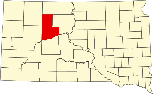
2234:
454:
82:
2732:
99:
3795:
2476:
2069:
2935:
2820:
3676:
2837:
2349:
3363:
2852:
2660:
431:. It is one of five South Dakota counties that are comprised entirely of land that is within the boundaries of Indian reservations.
420:
3476:
3418:
2832:
2788:
2666:
1955:
1060:
1055:
428:
2579:
2468:
3681:
3586:
3536:
3383:
2445:
619:
374:
3790:
3666:
3646:
3611:
3491:
3446:
3441:
3268:
3103:
2998:
2857:
2783:
2778:
651:
383:
55:
2003:
3741:
3656:
3636:
3621:
3471:
3388:
2847:
2342:
3746:
3711:
3701:
3696:
3686:
3626:
3601:
3596:
3576:
3551:
3531:
3526:
3506:
3461:
3436:
2893:
2455:
2376:
631:
607:
378:
2139:
3731:
3691:
3641:
3581:
3571:
3561:
3556:
3501:
3496:
3431:
3426:
3373:
3013:
2920:
2690:
2450:
2381:
2259:
1982:
1065:
613:
595:
415:
2126:
2125:
Squaw Teat Butte is the given name of this prominence on the following topographic map of the US Geological Survey:
3736:
3726:
3716:
3706:
3671:
3661:
3651:
3631:
3606:
3546:
3541:
3521:
3516:
3481:
3466:
3456:
3451:
3403:
3378:
3368:
2798:
2725:
2642:
2612:
2425:
2403:
975:
625:
601:
1933:
3721:
3616:
3591:
3566:
3486:
3308:
3228:
3193:
3178:
3173:
3138:
3063:
2988:
2973:
2808:
2793:
2632:
2589:
2584:
2546:
1002:
957:
922:
910:
866:
851:
836:
821:
806:
791:
776:
761:
746:
731:
716:
335:
2095:
3511:
3398:
3208:
3148:
3083:
3058:
3033:
2915:
2878:
2873:
2825:
2227:
386:
and
Sterling, which were the last three extinct counties of South Dakota to cease to exist. It was named for
3358:
3348:
3313:
3203:
3188:
3183:
3123:
3088:
3068:
3028:
3018:
2883:
2815:
2773:
2599:
581:
571:
561:
551:
541:
3303:
3293:
3283:
3278:
3263:
3223:
3168:
3048:
3008:
2943:
323:
46:
499:
3408:
3333:
3318:
3258:
3248:
3213:
3198:
3163:
3128:
3093:
3073:
3043:
3023:
2963:
2888:
2718:
2637:
2607:
970:
493:
505:
3393:
3338:
3328:
3288:
3273:
3253:
3243:
3238:
3218:
3158:
3153:
3133:
3118:
3113:
3053:
2755:
2697:
2541:
2522:
951:
343:
289:
192:
3770:
3323:
3298:
3143:
3038:
2978:
2953:
2622:
2569:
463:
439:
Ziebach County is part of the Great Plains and is characterized by rolling grasslands and numerous
2334:
2073:
475:
469:
448:
3233:
2652:
300:
279:
2160:
487:
481:
3078:
350:
2015:
387:
366:
180:
2205:
2958:
531:
411:
1959:
3784:
2968:
1035:
511:
88:
346:. It is the last county (or county equivalent) in the United States alphabetically.
2925:
2903:
2898:
2745:
2129:, Trails.com for the portion of USGS Rattlesnake Butte Quad, with Squaw Teat Butte.
1039:
934:
370:
331:
160:
73:
2948:
2515:
339:
187:
2741:
391:
327:
2320:
2307:
1912:
National
Register of Historic Places listings in Ziebach County, South Dakota
1047:
United States presidential election results for
Ziebach County, South Dakota
296:
275:
114:
101:
2983:
414:
flows east-northeastward along the southern boundary of
Ziebach County. The
373:
became a state, this county was dissolved in 1898 and its areas absorbed by
270:
937:, including 56.1% of those under age 18 and 22.9% of those age 65 or over.
2681:‡This populated place also has portions in an adjacent county or counties
175:
2710:
399:
17:
2282:
443:. The buttes form the highest points of elevation in Ziebach County:
424:
2182:
527:
440:
2228:"Census 2000 PHC-T-4. Ranking Tables for Counties: 1990 and 2000"
929:
the average family size was 3.82. The median age was 25.4 years.
2533:
577:
567:
557:
547:
537:
395:
2714:
2472:
2338:
2140:"County Population Totals and Components of Change: 2020-2023"
2070:""Find an Altitude" Google Maps (accessed February 9, 2019)"
2556:
1034:
Ziebach County has traditionally been a swing county. Only
2206:"Population of Counties by Decennial Census: 1900 to 1990"
2004:
History of SD Counties/Ziebach (accessed 9 February 2019)
423:. The balance of the county, along its extreme northern
2017:
South Dakota's Ziebach County, History of the Prairie
2020:. Dupree SD: Ziebach County Historical Society. 1982
3417:
3347:
3102:
2997:
2934:
2866:
2764:
2676:
2651:
2621:
2598:
2568:
2532:
307:
286:
269:
261:
248:
240:
235:
227:
219:
211:
206:
198:
186:
174:
166:
148:
130:
37:
1958:. National Association of Counties. Archived from
2365:Places adjacent to Ziebach County, South Dakota
2233:. United States Census Bureau. April 2, 2001.
2098:. United States Census Bureau. August 22, 2012
2726:
2484:
2350:
2260:"US Census Bureau, Table P16: Household Type"
8:
2204:Forstall, Richard L., ed. (March 27, 1995).
231:9.3 sq mi (24 km) 0.5%
2733:
2719:
2711:
2557:
2491:
2477:
2469:
2357:
2343:
2335:
1045:
689:
648:Cheyenne State Game Production Area (part)
355:fourth-poorest county in the United States
34:
2127:USGS Rattlesnake Butte Quad, South Dakota
1983:"A look inside America's poorest county"
1922:
306:
268:
234:
205:
185:
165:
129:
94:
64:
52:
2039:
2037:
2035:
709:
645:Bednor Lake State Game Production Area
365:A county named Ziebach was created in
1064:
1059:
1054:
1051:
285:
260:
247:
239:
226:
223:1,961 sq mi (5,080 km)
218:
215:1,971 sq mi (5,100 km)
210:
197:
173:
147:
79:
27:County in South Dakota, United States
7:
3806:Populated places established in 1911
2372:
2283:"Atlas of US Presidential Elections"
2240:from the original on October 9, 2022
1928:
1926:
3801:1911 establishments in South Dakota
87:South Dakota's location within the
2499:Municipalities and communities of
1981:Merchant, N. (February 13, 2011).
699:
460:Gray Butte 2,316 feet (706 m)
72:Location within the U.S. state of
25:
2661:Cheyenne River Indian Reservation
421:Cheyenne River Indian Reservation
3764:
2667:Standing Rock Indian Reservation
2434:
2417:
2409:
2392:
2185:. University of Virginia Library
576:
566:
556:
546:
536:
526:
429:Standing Rock Indian Reservation
338:, the population was 2,413. Its
254:
253:
153:
136:
81:
66:
54:
2045:"Ziebach County · South Dakota"
1934:"State & County QuickFacts"
652:Grand River National Grassland
1:
2435:
2393:
2262:. United States Census Bureau
2208:. United States Census Bureau
2163:. United States Census Bureau
2096:"2010 Census Gazetteer Files"
1936:. United States Census Bureau
3796:Ziebach County, South Dakota
3104:Smaller incorporated places
2502:Ziebach County, South Dakota
2418:
2415:Ziebach County, South Dakota
2410:
2999:Larger incorporated places
2183:"Historical Census Browser"
249: • Estimate
3822:
982:Unincorporated communities
3760:
2909:Colleges and universities
2752:
2686:
2554:
2513:
2370:
1086:
1083:
1080:
1077:
1074:
893:
880:
865:
850:
835:
820:
805:
790:
775:
760:
745:
730:
715:
708:
703:
698:
695:
95:
80:
65:
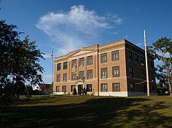
60:Ziebach County Courthouse
53:
44:
965:Census-designated places
369:in 1877. However, after
265:1.2/sq mi (0.47/km)
3771:South Dakota portal
2161:"U.S. Decennial Census"
1022:Unorganized territories
582:South Dakota Highway 73
572:South Dakota Highway 65
562:South Dakota Highway 63
552:South Dakota Highway 34
542:South Dakota Highway 20
514:2,733 feet (833 m)
508:2,365 feet (721 m)
502:2,356 feet (718 m)
496:2,411 feet (735 m)
490:2,365 feet (721 m)
484:2,500 feet (760 m)
478:2,484 feet (757 m)
472:2,165 feet (660 m)
466:2,395 feet (730 m)
457:2,484 feet (757 m)
451:2,474 feet (754 m)
394:Indians displaced from
2562:
308:Congressional district
32:County in South Dakota
3791:South Dakota counties
2964:Dissected Till Plains
2789:Famous South Dakotans
2560:
894:U.S. Decennial Census
691:Historical population
288: • Summer (
2699:United States portal
659:Lakes and reservoirs
262: • Density
3364:Colonial Pine Hills
2954:Coteau des Prairies
2843:Tourist attractions
2692:South Dakota portal
2653:Indian reservations
2317: /
2287:uselectionatlas.org
1048:
898:1990-2000 2010-2020
896:1790-1960 1900-1990
692:
500:Saint Patrick Butte
111: /
3106:pop. 1,000 - 5,000
2848:Towns and villages
2563:
2561:Ziebach County map
1985:. Associated Press
1046:
690:
427:, lies within the
241: • Total
228: • Water
212: • Total
3778:
3777:
3384:North Eagle Butte
2708:
2707:
2466:
2465:
2461:
2460:
2446:Pennington County
1903:
1902:
902:
901:
620:Pennington County
589:Adjacent counties
494:Rattlesnake Butte
351:per-capita income
317:
316:
220: • Land
16:(Redirected from
3813:
3769:
3768:
3767:
3269:North Sioux City
2735:
2728:
2721:
2712:
2700:
2693:
2559:
2525:
2518:
2508:
2503:
2493:
2486:
2479:
2470:
2438:
2437:
2421:
2420:
2413:
2412:
2396:
2395:
2373:
2359:
2352:
2345:
2336:
2332:
2331:
2329:
2328:
2327:
2322:
2321:44.98°N 101.67°W
2318:
2315:
2314:
2313:
2310:
2298:
2297:
2295:
2293:
2278:
2272:
2271:
2269:
2267:
2256:
2250:
2249:
2247:
2245:
2239:
2232:
2224:
2218:
2217:
2215:
2213:
2201:
2195:
2194:
2192:
2190:
2179:
2173:
2172:
2170:
2168:
2157:
2151:
2150:
2148:
2146:
2136:
2130:
2123:
2117:
2114:
2108:
2107:
2105:
2103:
2092:
2086:
2085:
2083:
2081:
2072:. Archived from
2066:
2060:
2059:
2057:
2055:
2041:
2030:
2029:
2027:
2025:
2012:
2006:
2001:
1995:
1994:
1992:
1990:
1978:
1972:
1971:
1969:
1967:
1952:
1946:
1945:
1943:
1941:
1930:
1066:Third party(ies)
1049:
994:
993:
989:
711:
706:
701:
693:
681:Rattlesnake Lake
671:
670:
666:
580:
570:
560:
550:
540:
532:U.S. Highway 212
530:
506:Squaw Teat Butte
388:Frank M. Ziebach
367:Dakota Territory
293:
257:
256:
181:Frank M. Ziebach
159:
157:
156:
144:
142:
140:
139:
126:
125:
123:
122:
121:
116:
115:44.98°N 101.67°W
112:
109:
108:
107:
104:
85:
70:
58:
35:
21:
3821:
3820:
3816:
3815:
3814:
3812:
3811:
3810:
3781:
3780:
3779:
3774:
3765:
3763:
3756:
3413:
3389:North Spearfish
3351:pop. over 1,000
3350:
3343:
3105:
3098:
3001:pop. over 5,000
3000:
2993:
2959:Missouri Coteau
2930:
2862:
2760:
2748:
2739:
2709:
2704:
2698:
2691:
2682:
2672:
2647:
2624:
2617:
2594:
2571:
2564:
2552:
2528:
2523:
2516:
2509:
2506:
2501:
2497:
2467:
2462:
2422:
2366:
2363:
2325:
2323:
2319:
2316:
2311:
2308:
2306:
2304:
2303:
2301:
2291:
2289:
2280:
2279:
2275:
2265:
2263:
2258:
2257:
2253:
2243:
2241:
2237:
2230:
2226:
2225:
2221:
2211:
2209:
2203:
2202:
2198:
2188:
2186:
2181:
2180:
2176:
2166:
2164:
2159:
2158:
2154:
2144:
2142:
2138:
2137:
2133:
2124:
2120:
2115:
2111:
2101:
2099:
2094:
2093:
2089:
2079:
2077:
2076:on May 21, 2019
2068:
2067:
2063:
2053:
2051:
2043:
2042:
2033:
2023:
2021:
2014:
2013:
2009:
2002:
1998:
1988:
1986:
1980:
1979:
1975:
1965:
1963:
1962:on May 31, 2011
1956:"Find a County"
1954:
1953:
1949:
1939:
1937:
1932:
1931:
1924:
1920:
1908:
1032:
1024:
1019:
995:
991:
987:
985:
984:
967:
948:
943:
919:
907:
897:
895:
704:
688:
672:
668:
664:
662:
661:
642:
640:Protected areas
637:
591:
586:
522:
517:
437:
408:
363:
287:
154:
152:
137:
135:
134:
119:
117:
113:
110:
105:
102:
100:
98:
97:
91:
76:
61:
49:
40:
33:
28:
23:
22:
15:
12:
11:
5:
3819:
3817:
3809:
3808:
3803:
3798:
3793:
3783:
3782:
3776:
3775:
3761:
3758:
3757:
3755:
3754:
3749:
3744:
3739:
3734:
3729:
3724:
3719:
3714:
3709:
3704:
3699:
3694:
3689:
3684:
3679:
3674:
3669:
3664:
3659:
3654:
3649:
3644:
3639:
3634:
3629:
3624:
3619:
3614:
3609:
3604:
3599:
3594:
3589:
3584:
3579:
3574:
3569:
3564:
3559:
3554:
3549:
3544:
3539:
3534:
3529:
3524:
3519:
3514:
3509:
3504:
3499:
3494:
3489:
3484:
3479:
3474:
3469:
3464:
3459:
3454:
3449:
3444:
3439:
3434:
3429:
3423:
3421:
3415:
3414:
3412:
3411:
3406:
3401:
3396:
3391:
3386:
3381:
3376:
3371:
3366:
3361:
3355:
3353:
3345:
3344:
3342:
3341:
3336:
3331:
3326:
3321:
3316:
3311:
3306:
3301:
3296:
3291:
3286:
3281:
3276:
3271:
3266:
3261:
3256:
3251:
3246:
3241:
3236:
3231:
3226:
3221:
3216:
3211:
3206:
3201:
3196:
3191:
3186:
3181:
3176:
3171:
3166:
3161:
3156:
3151:
3146:
3141:
3136:
3131:
3126:
3121:
3116:
3110:
3108:
3100:
3099:
3097:
3096:
3091:
3086:
3081:
3076:
3071:
3066:
3061:
3056:
3051:
3046:
3041:
3036:
3031:
3026:
3021:
3016:
3011:
3005:
3003:
2995:
2994:
2992:
2991:
2986:
2981:
2976:
2971:
2966:
2961:
2956:
2951:
2946:
2940:
2938:
2932:
2931:
2929:
2928:
2923:
2918:
2913:
2912:
2911:
2901:
2896:
2891:
2886:
2881:
2876:
2870:
2868:
2864:
2863:
2861:
2860:
2858:Transportation
2855:
2850:
2845:
2840:
2835:
2830:
2829:
2828:
2823:
2813:
2812:
2811:
2806:
2796:
2791:
2786:
2784:Climate change
2781:
2776:
2770:
2768:
2762:
2761:
2753:
2750:
2749:
2740:
2738:
2737:
2730:
2723:
2715:
2706:
2705:
2703:
2702:
2695:
2687:
2684:
2683:
2680:
2678:
2674:
2673:
2671:
2670:
2664:
2657:
2655:
2649:
2648:
2646:
2645:
2640:
2635:
2629:
2627:
2619:
2618:
2616:
2615:
2610:
2604:
2602:
2596:
2595:
2593:
2592:
2587:
2582:
2576:
2574:
2566:
2565:
2555:
2553:
2551:
2550:
2544:
2538:
2536:
2530:
2529:
2514:
2511:
2510:
2498:
2496:
2495:
2488:
2481:
2473:
2464:
2463:
2459:
2458:
2456:Stanley County
2453:
2448:
2442:
2441:
2439:
2432:
2429:
2428:
2423:
2408:
2406:
2400:
2399:
2397:
2390:
2387:
2386:
2384:
2379:
2377:Perkins County
2371:
2368:
2367:
2364:
2362:
2361:
2354:
2347:
2339:
2326:44.98; -101.67
2300:
2299:
2273:
2251:
2219:
2196:
2174:
2152:
2131:
2118:
2109:
2087:
2061:
2031:
2007:
1996:
1973:
1947:
1921:
1919:
1916:
1915:
1914:
1907:
1904:
1901:
1900:
1895:
1892:
1889:
1886:
1883:
1880:
1872:
1871:
1868:
1865:
1862:
1859:
1854:
1851:
1843:
1842:
1839:
1836:
1833:
1830:
1825:
1822:
1814:
1813:
1810:
1807:
1804:
1801:
1796:
1793:
1785:
1784:
1781:
1778:
1775:
1772:
1767:
1764:
1756:
1755:
1752:
1749:
1744:
1741:
1738:
1735:
1727:
1726:
1723:
1720:
1715:
1712:
1709:
1706:
1698:
1697:
1694:
1691:
1688:
1685:
1680:
1677:
1669:
1668:
1665:
1662:
1657:
1654:
1651:
1648:
1640:
1639:
1636:
1633:
1628:
1625:
1622:
1619:
1611:
1610:
1607:
1604:
1601:
1598:
1593:
1590:
1582:
1581:
1578:
1575:
1572:
1569:
1564:
1561:
1553:
1552:
1549:
1546:
1543:
1540:
1535:
1532:
1524:
1523:
1520:
1517:
1512:
1509:
1506:
1503:
1495:
1494:
1491:
1488:
1485:
1482:
1477:
1474:
1466:
1465:
1462:
1459:
1456:
1453:
1448:
1445:
1437:
1436:
1433:
1430:
1425:
1422:
1419:
1416:
1408:
1407:
1404:
1401:
1398:
1395:
1390:
1387:
1379:
1378:
1375:
1372:
1369:
1366:
1361:
1358:
1350:
1349:
1346:
1343:
1338:
1335:
1332:
1329:
1321:
1320:
1317:
1314:
1311:
1308:
1303:
1300:
1292:
1291:
1288:
1285:
1280:
1277:
1274:
1271:
1263:
1262:
1259:
1256:
1253:
1250:
1245:
1242:
1234:
1233:
1230:
1227:
1222:
1219:
1216:
1213:
1205:
1204:
1201:
1198:
1193:
1190:
1187:
1184:
1176:
1175:
1172:
1169:
1164:
1161:
1158:
1155:
1147:
1146:
1143:
1140:
1137:
1134:
1129:
1126:
1118:
1117:
1114:
1111:
1106:
1103:
1100:
1097:
1089:
1088:
1085:
1082:
1079:
1076:
1073:
1069:
1068:
1063:
1058:
1053:
1031:
1028:
1023:
1020:
1018:
1017:
1014:
1011:
1008:
1007:Iron Lightning
1005:
1000:
996:
983:
980:
979:
978:
973:
966:
963:
962:
961:
955:
947:
944:
942:
939:
918:
915:
906:
903:
900:
899:
891:
890:
887:
885:
882:
878:
877:
874:
872:
869:
863:
862:
859:
857:
854:
848:
847:
844:
842:
839:
833:
832:
829:
827:
824:
818:
817:
814:
812:
809:
803:
802:
799:
797:
794:
788:
787:
784:
782:
779:
773:
772:
769:
767:
764:
758:
757:
754:
752:
749:
743:
742:
739:
737:
734:
728:
727:
724:
722:
719:
713:
712:
707:
702:
697:
687:
684:
683:
682:
679:
676:
660:
657:
656:
655:
649:
646:
641:
638:
636:
635:
632:Perkins County
629:
623:
617:
611:
608:Stanley County
605:
599:
592:
590:
587:
585:
584:
574:
564:
554:
544:
534:
523:
521:
520:Major highways
518:
516:
515:
509:
503:
497:
491:
485:
479:
473:
467:
461:
458:
452:
445:
436:
433:
412:Cheyenne River
407:
404:
362:
359:
320:Ziebach County
315:
314:
309:
305:
304:
294:
284:
283:
273:
267:
266:
263:
259:
258:
250:
246:
245:
242:
238:
237:
233:
232:
229:
225:
224:
221:
217:
216:
213:
209:
208:
204:
203:
200:
196:
195:
190:
184:
183:
178:
172:
171:
168:
164:
163:
150:
146:
145:
132:
128:
127:
120:44.98; -101.67
93:
92:
86:
78:
77:
71:
63:
62:
59:
51:
50:
45:
42:
41:
39:Ziebach County
38:
31:
26:
24:
14:
13:
10:
9:
6:
4:
3:
2:
3818:
3807:
3804:
3802:
3799:
3797:
3794:
3792:
3789:
3788:
3786:
3773:
3772:
3759:
3753:
3750:
3748:
3745:
3743:
3740:
3738:
3735:
3733:
3730:
3728:
3725:
3723:
3720:
3718:
3715:
3713:
3710:
3708:
3705:
3703:
3700:
3698:
3695:
3693:
3690:
3688:
3685:
3683:
3680:
3678:
3677:Oglala Lakota
3675:
3673:
3670:
3668:
3665:
3663:
3660:
3658:
3655:
3653:
3650:
3648:
3645:
3643:
3640:
3638:
3635:
3633:
3630:
3628:
3625:
3623:
3620:
3618:
3615:
3613:
3610:
3608:
3605:
3603:
3600:
3598:
3595:
3593:
3590:
3588:
3585:
3583:
3580:
3578:
3575:
3573:
3570:
3568:
3565:
3563:
3560:
3558:
3555:
3553:
3550:
3548:
3545:
3543:
3540:
3538:
3535:
3533:
3530:
3528:
3525:
3523:
3520:
3518:
3515:
3513:
3510:
3508:
3505:
3503:
3500:
3498:
3495:
3493:
3490:
3488:
3485:
3483:
3480:
3478:
3475:
3473:
3470:
3468:
3465:
3463:
3460:
3458:
3455:
3453:
3450:
3448:
3445:
3443:
3440:
3438:
3435:
3433:
3430:
3428:
3425:
3424:
3422:
3420:
3416:
3410:
3407:
3405:
3402:
3400:
3397:
3395:
3392:
3390:
3387:
3385:
3382:
3380:
3377:
3375:
3374:Fort Thompson
3372:
3370:
3367:
3365:
3362:
3360:
3357:
3356:
3354:
3352:
3349:Largest CDPs
3346:
3340:
3337:
3335:
3332:
3330:
3327:
3325:
3322:
3320:
3317:
3315:
3312:
3310:
3307:
3305:
3302:
3300:
3297:
3295:
3292:
3290:
3287:
3285:
3282:
3280:
3277:
3275:
3272:
3270:
3267:
3265:
3262:
3260:
3257:
3255:
3252:
3250:
3247:
3245:
3242:
3240:
3237:
3235:
3232:
3230:
3227:
3225:
3222:
3220:
3217:
3215:
3212:
3210:
3207:
3205:
3202:
3200:
3197:
3195:
3192:
3190:
3187:
3185:
3182:
3180:
3177:
3175:
3172:
3170:
3167:
3165:
3162:
3160:
3157:
3155:
3152:
3150:
3147:
3145:
3142:
3140:
3137:
3135:
3132:
3130:
3127:
3125:
3122:
3120:
3117:
3115:
3112:
3111:
3109:
3107:
3101:
3095:
3092:
3090:
3087:
3085:
3082:
3080:
3077:
3075:
3072:
3070:
3067:
3065:
3062:
3060:
3057:
3055:
3052:
3050:
3047:
3045:
3042:
3040:
3037:
3035:
3032:
3030:
3027:
3025:
3022:
3020:
3017:
3015:
3014:Belle Fourche
3012:
3010:
3007:
3006:
3004:
3002:
2996:
2990:
2987:
2985:
2982:
2980:
2977:
2975:
2972:
2970:
2969:Drift Prairie
2967:
2965:
2962:
2960:
2957:
2955:
2952:
2950:
2947:
2945:
2942:
2941:
2939:
2937:
2933:
2927:
2924:
2922:
2919:
2917:
2914:
2910:
2907:
2906:
2905:
2902:
2900:
2897:
2895:
2892:
2890:
2887:
2885:
2882:
2880:
2877:
2875:
2872:
2871:
2869:
2865:
2859:
2856:
2854:
2851:
2849:
2846:
2844:
2841:
2839:
2836:
2834:
2831:
2827:
2824:
2822:
2819:
2818:
2817:
2814:
2810:
2807:
2805:
2802:
2801:
2800:
2797:
2795:
2792:
2790:
2787:
2785:
2782:
2780:
2777:
2775:
2772:
2771:
2769:
2767:
2763:
2758:
2757:
2751:
2747:
2743:
2736:
2731:
2729:
2724:
2722:
2717:
2716:
2713:
2701:
2696:
2694:
2689:
2688:
2685:
2679:
2675:
2668:
2665:
2662:
2659:
2658:
2656:
2654:
2650:
2644:
2641:
2639:
2636:
2634:
2631:
2630:
2628:
2626:
2620:
2614:
2611:
2609:
2606:
2605:
2603:
2601:
2597:
2591:
2590:South Ziebach
2588:
2586:
2585:North Ziebach
2583:
2581:
2578:
2577:
2575:
2573:
2567:
2548:
2545:
2543:
2540:
2539:
2537:
2535:
2531:
2527:
2526:
2519:
2512:
2507:United States
2504:
2494:
2489:
2487:
2482:
2480:
2475:
2474:
2471:
2457:
2454:
2452:
2451:Haakon County
2449:
2447:
2444:
2443:
2440:
2433:
2431:
2430:
2427:
2424:
2416:
2407:
2405:
2402:
2401:
2398:
2391:
2389:
2388:
2385:
2383:
2382:Corson County
2380:
2378:
2375:
2374:
2369:
2360:
2355:
2353:
2348:
2346:
2341:
2340:
2337:
2333:
2330:
2288:
2284:
2281:Leip, David.
2277:
2274:
2261:
2255:
2252:
2236:
2229:
2223:
2220:
2207:
2200:
2197:
2184:
2178:
2175:
2162:
2156:
2153:
2141:
2135:
2132:
2128:
2122:
2119:
2113:
2110:
2097:
2091:
2088:
2075:
2071:
2065:
2062:
2050:
2046:
2040:
2038:
2036:
2032:
2019:
2018:
2011:
2008:
2005:
2000:
1997:
1984:
1977:
1974:
1961:
1957:
1951:
1948:
1935:
1929:
1927:
1923:
1917:
1913:
1910:
1909:
1905:
1899:
1896:
1893:
1890:
1887:
1884:
1881:
1879:
1878:
1874:
1873:
1869:
1866:
1863:
1860:
1858:
1855:
1852:
1850:
1849:
1845:
1844:
1840:
1837:
1834:
1831:
1829:
1826:
1823:
1821:
1820:
1816:
1815:
1811:
1808:
1805:
1802:
1800:
1797:
1794:
1792:
1791:
1787:
1786:
1782:
1779:
1776:
1773:
1771:
1768:
1765:
1763:
1762:
1758:
1757:
1753:
1750:
1748:
1745:
1742:
1739:
1736:
1734:
1733:
1729:
1728:
1724:
1721:
1719:
1716:
1713:
1710:
1707:
1705:
1704:
1700:
1699:
1695:
1692:
1689:
1686:
1684:
1681:
1678:
1676:
1675:
1671:
1670:
1666:
1663:
1661:
1658:
1655:
1652:
1649:
1647:
1646:
1642:
1641:
1637:
1634:
1632:
1629:
1626:
1623:
1620:
1618:
1617:
1613:
1612:
1608:
1605:
1602:
1599:
1597:
1594:
1591:
1589:
1588:
1584:
1583:
1579:
1576:
1573:
1570:
1568:
1565:
1562:
1560:
1559:
1555:
1554:
1550:
1547:
1544:
1541:
1539:
1536:
1533:
1531:
1530:
1526:
1525:
1521:
1518:
1516:
1513:
1510:
1507:
1504:
1502:
1501:
1497:
1496:
1492:
1489:
1486:
1483:
1481:
1478:
1475:
1473:
1472:
1468:
1467:
1463:
1460:
1457:
1454:
1452:
1449:
1446:
1444:
1443:
1439:
1438:
1434:
1431:
1429:
1426:
1423:
1420:
1417:
1415:
1414:
1410:
1409:
1405:
1402:
1399:
1396:
1394:
1391:
1388:
1386:
1385:
1381:
1380:
1376:
1373:
1370:
1367:
1365:
1362:
1359:
1357:
1356:
1352:
1351:
1347:
1344:
1342:
1339:
1336:
1333:
1330:
1328:
1327:
1323:
1322:
1318:
1315:
1312:
1309:
1307:
1304:
1301:
1299:
1298:
1294:
1293:
1289:
1286:
1284:
1281:
1278:
1275:
1272:
1270:
1269:
1265:
1264:
1260:
1257:
1254:
1251:
1249:
1246:
1243:
1241:
1240:
1236:
1235:
1231:
1228:
1226:
1223:
1220:
1217:
1214:
1212:
1211:
1207:
1206:
1202:
1199:
1197:
1194:
1191:
1188:
1185:
1183:
1182:
1178:
1177:
1173:
1170:
1168:
1165:
1162:
1159:
1156:
1154:
1153:
1149:
1148:
1144:
1141:
1138:
1135:
1133:
1130:
1127:
1125:
1124:
1120:
1119:
1115:
1112:
1110:
1107:
1104:
1101:
1098:
1096:
1095:
1091:
1090:
1071:
1070:
1067:
1062:
1057:
1050:
1044:
1041:
1037:
1036:Ronald Reagan
1029:
1027:
1021:
1016:Thunder Butte
1015:
1012:
1009:
1006:
1004:
1001:
998:
997:
990:
981:
977:
974:
972:
969:
968:
964:
959:
956:
954:(county seat)
953:
950:
949:
945:
940:
938:
936:
930:
926:
924:
916:
914:
912:
904:
892:
888:
886:
883:
879:
875:
873:
870:
868:
864:
860:
858:
855:
853:
849:
845:
843:
840:
838:
834:
830:
828:
825:
823:
819:
815:
813:
810:
808:
804:
800:
798:
795:
793:
789:
785:
783:
780:
778:
774:
770:
768:
765:
763:
759:
755:
753:
750:
748:
744:
740:
738:
735:
733:
729:
725:
723:
720:
718:
714:
694:
685:
680:
677:
674:
673:
667:
658:
653:
650:
647:
644:
643:
639:
633:
630:
627:
624:
621:
618:
615:
614:Haakon County
612:
609:
606:
603:
600:
597:
596:Corson County
594:
593:
588:
583:
579:
575:
573:
569:
565:
563:
559:
555:
553:
549:
545:
543:
539:
535:
533:
529:
525:
524:
519:
513:
512:Thunder Butte
510:
507:
504:
501:
498:
495:
492:
489:
486:
483:
480:
477:
474:
471:
468:
465:
464:High Elk Hill
462:
459:
456:
453:
450:
447:
446:
444:
442:
434:
432:
430:
426:
422:
417:
413:
405:
403:
401:
397:
393:
389:
385:
380:
376:
372:
368:
360:
358:
356:
353:makes it the
352:
349:The county's
347:
345:
341:
337:
333:
329:
325:
321:
313:
310:
302:
298:
295:
291:
281:
277:
274:
272:
264:
251:
243:
230:
222:
214:
201:
194:
191:
189:
182:
179:
177:
169:
162:
151:
143:United States
133:
124:
96:Coordinates:
90:
84:
75:
69:
57:
48:
43:
36:
30:
19:
3762:
3751:
3404:Rapid Valley
3379:Green Valley
3369:Dakota Dunes
2894:Demographics
2821:Bibliography
2754:
2746:South Dakota
2643:Red Scaffold
2613:Cherry Creek
2521:
2500:
2426:Dewey County
2414:
2404:Meade County
2302:
2290:. Retrieved
2286:
2276:
2264:. Retrieved
2254:
2242:. Retrieved
2222:
2210:. Retrieved
2199:
2187:. Retrieved
2177:
2165:. Retrieved
2155:
2143:. Retrieved
2134:
2121:
2112:
2100:. Retrieved
2090:
2078:. Retrieved
2074:the original
2064:
2052:. Retrieved
2048:
2024:November 11,
2022:. Retrieved
2016:
2010:
1999:
1987:. Retrieved
1976:
1964:. Retrieved
1960:the original
1950:
1938:. Retrieved
1897:
1875:
1856:
1846:
1827:
1817:
1798:
1788:
1769:
1759:
1746:
1730:
1717:
1701:
1682:
1672:
1659:
1643:
1630:
1614:
1595:
1585:
1566:
1556:
1537:
1527:
1514:
1498:
1479:
1469:
1450:
1440:
1427:
1411:
1392:
1382:
1363:
1353:
1340:
1324:
1305:
1295:
1282:
1266:
1247:
1237:
1224:
1208:
1195:
1179:
1166:
1150:
1131:
1121:
1108:
1092:
1040:Barack Obama
1038:in 1980 and
1033:
1025:
1013:Red Scaffold
976:Cherry Creek
935:poverty line
931:
927:
920:
908:
686:Demographics
626:Meade County
602:Dewey County
476:Marple Butte
470:Joshua Butte
449:Bessie Butte
438:
416:Moreau River
409:
371:South Dakota
364:
348:
334:. As of the
332:South Dakota
319:
318:
199:Largest city
161:South Dakota
74:South Dakota
29:
3477:Charles Mix
3309:Springfield
3229:Hot Springs
3194:Fort Pierre
3179:Eagle Butte
3174:Dell Rapids
3139:Chamberlain
3064:Sioux Falls
2949:Black Hills
2921:LGBT rights
2833:State Parks
2804:Delegations
2633:Glad Valley
2625:communities
2572:territories
2570:Unorganized
2547:Eagle Butte
2517:County seat
2324: /
2080:February 9,
2049:Google Maps
1003:Glad Valley
958:Eagle Butte
941:Communities
923:2010 census
917:2010 census
911:2020 census
905:2020 census
881:2023 (est.)
675:Bedners Dam
634:- northwest
622:- southwest
610:- southeast
455:Eagle Butte
425:county line
340:county seat
336:2020 census
118: /
3785:Categories
3682:Pennington
3587:Hutchinson
3537:Fall River
3399:Pine Ridge
3209:Gettysburg
3149:Clear Lake
3084:Vermillion
3059:Rapid City
3034:Harrisburg
2989:West River
2979:Pine Ridge
2974:East River
2799:Government
1918:References
1084:No.
1078:No.
1072:No.
1061:Democratic
1056:Republican
921:As of the
909:As of the
375:Pennington
328:U.S. state
236:Population
3667:Minnehaha
3647:McPherson
3612:Kingsbury
3492:Codington
3447:Brookings
3442:Bon Homme
3359:Blackhawk
3314:Summerset
3204:Garretson
3189:Flandreau
3184:Elk Point
3124:Beresford
3089:Watertown
3069:Spearfish
3029:Brookings
3019:Box Elder
2984:Siouxland
2904:Education
2853:Townships
2809:Elections
2794:Geography
2759:(capital)
2677:Footnotes
2292:April 15,
2266:March 20,
2244:March 28,
2212:March 28,
2189:March 28,
2167:March 28,
2145:March 17,
2102:March 28,
2054:April 27,
1940:March 20,
960:(partial)
488:Mud Butte
482:Mud Butte
406:Geography
384:Armstrong
271:Time zone
176:Named for
3742:Walworth
3657:Mellette
3637:Marshall
3622:Lawrence
3472:Campbell
3419:Counties
3304:Sisseton
3294:Redfield
3284:Piedmont
3279:Parkston
3264:Mobridge
3224:Hartford
3169:Deadwood
3049:Mitchell
3009:Aberdeen
2944:Badlands
2926:Politics
2916:Gun laws
2879:Cannabis
2874:Abortion
2826:Timeline
2312:101°40′W
2235:Archived
1989:April 4,
1906:See also
1030:Politics
312:At-large
280:Mountain
106:101°40′W
3752:Ziebach
3747:Yankton
3712:Stanley
3702:Sanborn
3697:Roberts
3687:Perkins
3627:Lincoln
3602:Jerauld
3597:Jackson
3577:Harding
3552:Gregory
3532:Edmunds
3527:Douglas
3507:Davison
3462:Buffalo
3437:Bennett
3409:Rosebud
3334:Webster
3319:Tyndall
3259:Mission
3249:Milbank
3214:Gregory
3199:Freeman
3164:De Smet
3129:Britton
3094:Yankton
3074:Sturgis
3044:Madison
3024:Brandon
2936:Regions
2899:Economy
2884:Culture
2867:Society
2838:Symbols
2816:History
2774:Outline
2638:Red Elm
2608:Bridger
2309:44°59′N
1966:June 7,
1891:45.56%
1864:42.12%
1841:11.74%
1835:22.84%
1812:32.22%
1806:12.77%
1777:44.57%
1740:31.36%
1711:42.53%
1690:49.85%
1653:48.32%
1624:47.24%
1603:32.32%
1574:42.95%
1545:47.41%
1508:44.66%
1487:40.98%
1458:43.45%
1421:48.49%
1400:30.60%
1371:45.33%
1334:45.53%
1319:16.71%
1313:38.36%
1276:40.32%
1255:43.55%
1218:40.05%
1189:35.02%
1160:41.26%
1139:46.02%
1102:44.59%
1010:Red Elm
971:Bridger
678:K C Dam
616:- south
598:- north
400:Wyoming
379:Stanley
361:History
326:in the
167:Founded
131:Country
103:44°59′N
18:Ziebach
3732:Turner
3692:Potter
3642:McCook
3582:Hughes
3572:Hanson
3562:Hamlin
3557:Haakon
3502:Custer
3497:Corson
3432:Beadle
3427:Aurora
3394:Oglala
3339:Winner
3329:Wagner
3289:Platte
3274:Parker
3254:Miller
3244:Lennox
3239:Lemmon
3219:Groton
3159:Custer
3154:Crooks
3134:Canton
3119:Baltic
3114:Aurora
3054:Pierre
2779:Cities
2766:Topics
2756:Pierre
2580:Dupree
2542:Dupree
2534:Cities
2524:Dupree
1898:54.44%
1885:0.00%
1870:2.99%
1857:54.89%
1828:65.42%
1799:55.01%
1783:0.43%
1770:55.00%
1754:1.97%
1747:66.67%
1725:1.59%
1718:55.88%
1696:0.00%
1683:50.15%
1667:0.00%
1660:51.68%
1638:1.43%
1631:51.33%
1609:0.00%
1596:67.68%
1580:0.00%
1567:57.05%
1551:0.00%
1538:52.59%
1522:0.00%
1515:55.34%
1493:6.44%
1480:52.58%
1464:0.69%
1451:55.86%
1435:2.89%
1428:48.62%
1406:4.35%
1393:65.05%
1377:0.51%
1364:54.17%
1348:0.75%
1341:53.71%
1306:44.93%
1290:7.74%
1283:51.94%
1261:3.19%
1248:53.26%
1232:2.51%
1225:57.44%
1203:2.81%
1196:62.18%
1174:1.05%
1167:57.69%
1145:6.00%
1132:47.98%
1116:2.32%
1109:53.09%
986:": -->
952:Dupree
946:Cities
876:−13.9%
801:−11.0%
756:−28.8%
696:Census
663:": -->
654:(part)
628:- west
604:- east
441:buttes
435:Buttes
344:Dupree
324:county
252:2,322
202:Dupree
193:Dupree
158:
141:
47:County
3737:Union
3727:Tripp
3717:Sully
3707:Spink
3672:Moody
3662:Miner
3652:Meade
3632:Lyman
3607:Jones
3547:Grant
3542:Faulk
3522:Dewey
3517:Deuel
3482:Clark
3467:Butte
3457:Brule
3452:Brown
3324:Volga
3299:Salem
3144:Clark
3039:Huron
2889:Crime
2742:State
2623:Other
2238:(PDF)
2231:(PDF)
1052:Year
999:Chase
889:−3.8%
884:2,322
871:2,413
861:11.2%
856:2,801
846:13.5%
841:2,519
831:−3.8%
826:2,220
811:2,308
796:2,221
786:−4.3%
781:2,495
771:−9.4%
766:2,606
751:2,875
736:4,039
721:3,718
322:is a
297:UTC−6
276:UTC−7
244:2,413
149:State
3722:Todd
3617:Lake
3592:Hyde
3567:Hand
3487:Clay
3234:Lead
2600:CDPs
2294:2018
2268:2024
2246:2015
2214:2015
2191:2015
2169:2015
2147:2024
2104:2015
2082:2019
2056:2024
2026:2012
1991:2012
1968:2011
1942:2024
1894:417
1888:349
1877:1912
1861:211
1853:275
1848:1916
1832:177
1824:507
1819:1920
1809:386
1803:153
1795:659
1790:1924
1774:615
1766:759
1761:1928
1743:982
1737:462
1732:1932
1714:737
1708:561
1703:1936
1687:687
1679:691
1674:1940
1656:354
1650:331
1645:1944
1627:503
1621:463
1616:1948
1600:372
1592:779
1587:1952
1571:472
1563:627
1558:1956
1542:512
1534:568
1529:1960
1511:554
1505:447
1500:1964
1484:350
1476:449
1471:1968
1455:378
1447:486
1442:1972
1424:370
1418:369
1413:1976
1397:246
1389:523
1384:1980
1368:359
1360:429
1355:1984
1337:427
1331:362
1326:1988
1316:122
1310:280
1302:328
1297:1992
1279:483
1273:375
1268:1996
1252:314
1244:384
1239:2000
1221:641
1215:447
1210:2004
1192:554
1186:312
1181:2008
1163:439
1157:314
1152:2012
1136:353
1128:368
1123:2016
1105:481
1099:404
1094:2020
988:edit
867:2020
852:2010
837:2000
822:1990
816:3.9%
807:1980
792:1970
777:1960
762:1950
747:1940
741:8.6%
732:1930
717:1920
705:Note
700:Pop.
665:edit
410:The
398:and
396:Utah
377:and
207:Area
188:Seat
170:1911
89:U.S.
3512:Day
3079:Tea
2744:of
1867:15
1838:91
1751:29
1722:21
1635:14
1490:55
1432:22
1403:35
1287:72
1258:23
1229:28
1200:25
1142:46
1113:21
392:Ute
342:is
330:of
301:MDT
290:DST
3787::
2520::
2505:,
2285:.
2047:.
2034:^
1925:^
1882:0
1780:6
1693:0
1664:0
1606:0
1577:0
1548:0
1519:0
1461:6
1374:4
1345:6
1171:8
1087:%
710:%±
357:.
2734:e
2727:t
2720:v
2669:‡
2663:‡
2549:‡
2492:e
2485:t
2478:v
2358:e
2351:t
2344:v
2296:.
2270:.
2248:.
2216:.
2193:.
2171:.
2149:.
2106:.
2084:.
2058:.
2028:.
1993:.
1970:.
1944:.
1081:%
1075:%
992:]
726:—
669:]
303:)
299:(
292:)
282:)
278:(
20:)
Text is available under the Creative Commons Attribution-ShareAlike License. Additional terms may apply.