137:
506:
25:
337:
station and past the
Galluswarte watch tower, which marks the historic walls of Frankfurt. The section of the road in Gallus is known for its high concentration of car dealerships and garages. An alternative tram route to the south lets trams bypass part of Mainzer Landstraße around Galluswarte and a
259:, Mainzer Landstraße has become less important for long distance travel and now mostly facilitates travel around the west end of the city. Accordingly, it was downgraded from a regional road (
380:, and terminates in Höchst where it meets Bolongarostraße. This road, and its continuation Brüningstraße, runs through the old town and Industriepark Höchst, the headquarters of
408:
46:
307:
161:
284:
97:
116:
69:
76:
330:. The tramlines join Mainzer Landstraße at Platz der Republik, and the road then continues into Gallus, where it passes under
587:
276:
165:
50:
613:
450:
331:
83:
582:
252:, there were around 40 factories along the length of the road, with more along the many side roads that branch off it.
490:
401:
35:
65:
323:
280:
245:
54:
39:
566:
445:
311:
208:, running west from the city centre to the outlying suburbs of the city. The road runs largely parallel with the
470:
455:
296:
608:
228:. As one of the most heavily used roads in Frankfurt, factories soon sprang up along its length as Germany
212:
along its northern bank, and at 8.3 kilometres (5.2 mi) in length is
Frankfurt's second longest road.
394:
460:
292:
136:
300:
175:
90:
315:
288:
233:
551:
536:
440:
362:
334:
256:
229:
205:
495:
354:
546:
358:
260:
264:
602:
417:
377:
365:
with the city centre and
Bundesautobahn 66, near Nied. The tramway runs on a special
343:
319:
201:
505:
465:
370:
248:, soon followed, supported by the industries along its length. By the outbreak of
346:
at Mönchhofstraße on the outskirts of Gallus let trams stop and reverse there at
541:
249:
24:
561:
475:
381:
209:
142:
386:
220:
The road was built between 1746 and 1750 as part of the longer route between
520:
480:
435:
421:
347:
339:
327:
221:
366:
237:
485:
373:
at Nied Kirche (Nied Church) allows the 21 line to terminate there.
16:
One of the main arterial roads in
Frankfurt am Main, Hesse, Germany
353:
At the border between Gallus and
Griesheim, the road passes under
225:
241:
390:
18:
575:
529:
513:
428:
232:in the 19th century, including the headquarters of
186:
181:
171:
157:
149:
402:
8:
129:
53:. Unsourced material may be challenged and
409:
395:
387:
135:
128:
117:Learn how and when to remove this message
318:at Platz der Republik, it passes the
7:
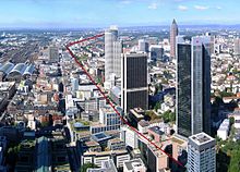
141:Mainzer Landstraße as seen from the
51:adding citations to reliable sources
279:, Mainzer Landstraße runs through
14:
504:
23:
314:. Between Taunusanlage and the
588:Frankfurt Taunusanlage station
1:
429:Notable buildings (financial)
583:Frankfurt Hauptwache station
530:Notable squares and streets
491:Trianon (Frankfurt am Main)
630:
376:The road then crosses the
369:above the junction, and a
502:
446:Deutsche Bank Twin Towers
312:Deutsche Bank Twin Towers
153:8.3 km (5.2 mi)
134:
471:Japan Center (Frankfurt)
456:Frankfurt Stock Exchange
324:Frankfurter Büro Center
263:) to a district road (
461:Gallileo (skyscraper)
451:Eurotower (Frankfurt)
614:Streets in Frankfurt
308:Taunusanlage station
255:With the opening of
166:Frankfurt Innenstadt
66:"Mainzer Landstraße"
47:improve this article
514:Notable attractions
361:40, which connects
306:The road begins at
200:is one of the main
131:
557:Mainzer Landstraße
198:Mainzer Landstraße
130:Mainzer Landstraße
596:
595:
441:Commerzbank Tower
363:Frankfurt Airport
257:Bundesautobahn 66
244:, the modern day
206:Frankfurt am Main
194:
193:
127:
126:
119:
101:
621:
576:Public transport
508:
496:Westendstrasse 1
411:
404:
397:
388:
357:before it meets
355:Bundesautobahn 5
139:
132:
122:
115:
111:
108:
102:
100:
59:
27:
19:
629:
628:
624:
623:
622:
620:
619:
618:
599:
598:
597:
592:
571:
552:Kaiserhofstraße
525:
509:
500:
424:
415:
310:, close to the
285:Bahnhofsviertel
273:
246:lines 11 and 21
218:
145:
123:
112:
106:
103:
60:
58:
44:
28:
17:
12:
11:
5:
627:
625:
617:
616:
611:
609:Roads in Hesse
601:
600:
594:
593:
591:
590:
585:
579:
577:
573:
572:
570:
569:
564:
559:
554:
549:
544:
539:
533:
531:
527:
526:
524:
523:
517:
515:
511:
510:
503:
501:
499:
498:
493:
488:
483:
478:
473:
468:
463:
458:
453:
448:
443:
438:
432:
430:
426:
425:
416:
414:
413:
406:
399:
391:
299:on the way to
272:
269:
230:industrialised
217:
214:
202:arterial roads
192:
191:
188:
184:
183:
179:
178:
173:
169:
168:
159:
155:
154:
151:
147:
146:
140:
125:
124:
31:
29:
22:
15:
13:
10:
9:
6:
4:
3:
2:
626:
615:
612:
610:
607:
606:
604:
589:
586:
584:
581:
580:
578:
574:
568:
565:
563:
560:
558:
555:
553:
550:
548:
545:
543:
540:
538:
535:
534:
532:
528:
522:
519:
518:
516:
512:
507:
497:
494:
492:
489:
487:
484:
482:
479:
477:
474:
472:
469:
467:
464:
462:
459:
457:
454:
452:
449:
447:
444:
442:
439:
437:
434:
433:
431:
427:
423:
419:
418:Bankenviertel
412:
407:
405:
400:
398:
393:
392:
389:
385:
383:
379:
374:
372:
368:
364:
360:
356:
351:
349:
345:
341:
336:
333:
329:
325:
321:
320:Westend Tower
317:
313:
309:
304:
302:
298:
294:
290:
286:
282:
278:
270:
268:
266:
262:
258:
253:
251:
247:
243:
239:
235:
231:
227:
223:
215:
213:
211:
207:
203:
199:
189:
185:
180:
177:
174:
172:West end
170:
167:
163:
160:
158:East end
156:
152:
148:
144:
138:
133:
121:
118:
110:
99:
96:
92:
89:
85:
82:
78:
75:
71:
68: –
67:
63:
62:Find sources:
56:
52:
48:
42:
41:
37:
32:This article
30:
26:
21:
20:
556:
547:Goethestraße
537:Börsenstraße
466:Garden Tower
375:
371:balloon loop
359:Bundesstraße
352:
305:
274:
261:Landesstraße
254:
219:
197:
195:
187:Inauguration
182:Construction
162:Taunusanlage
113:
104:
94:
87:
80:
73:
61:
45:Please help
33:
378:River Nidda
332:Galluswarte
265:Kreisstraße
250:World War I
603:Categories
567:Hochstraße
562:Opernplatz
476:Main Tower
382:Hoechst AG
316:crossroads
277:Innenstadt
210:River Main
143:Main Tower
77:newspapers
521:Alte Oper
481:Opernturm
436:City-Haus
422:Frankfurt
340:headshunt
328:City-Haus
293:Griesheim
275:From the
222:Frankfurt
34:does not
542:Freßgass
367:overpass
348:off-peak
326:and the
107:May 2019
350:times.
281:Westend
242:tramway
238:Tenovis
216:History
91:scholar
55:removed
40:sources
486:Skyper
344:siding
335:S-Bahn
322:, the
301:Höchst
289:Gallus
176:Höchst
150:Length
93:
86:
79:
72:
64:
342:tram
271:Route
234:Adler
226:Mainz
98:JSTOR
84:books
297:Nied
295:and
240:. A
236:and
224:and
196:The
190:1750
70:news
38:any
36:cite
420:of
267:).
204:in
49:by
605::
384:.
303:.
291:,
287:,
283:,
164:,
410:e
403:t
396:v
120:)
114:(
109:)
105:(
95:·
88:·
81:·
74:·
57:.
43:.
Text is available under the Creative Commons Attribution-ShareAlike License. Additional terms may apply.