288:
26:
382:
228:
213:
89:
414:
108:
451:
304:. West of the creek, the state highway reaches a four-way intersection with south-facing St. Marks Road and Gapland Road, which heads west toward Burkittsville. MD 383 turns north to remain on Broad Run Road. The state highway passes Poffenberger Road and Sumantown Road as it veers west again. Poffenberger Road leads to the historic
518:
324:
The first portion of MD 383 was constructed as a concrete road from MD 33 (now MD 17) south to Broad Run in 1929 and 1930. The state highway was extended east as a macadam road to near the
Poffenberger Road intersection in 1934 and 1935. By 1946, MD 383 was extended south and east to Catoctin
295:
MD 383 begins at a T intersection with MD 180 (Jefferson Pike) a short distance west of the center of
Jefferson. The state highway heads northwest as a two-lane undivided road through farmland. MD 383 intersects Corun Road, which leads to the historic
287:
312:. Picnic Woods Road and Catholic Church Road head west and south, respectively, from the intersection. MD 383 turns north to its northern terminus at MD 17 (Burkittsville Road) about midway between Burkittsville and
308:
and
Sumantown Road leads to the contemporary Catoctin Creek Park. MD 383 crosses a tributary of Broad Run and reaches another four-way intersection at the hamlet of
769:
698:
654:
610:
740:
181:
56:
764:
191:
186:
196:
673:
338:
326:
154:
301:
305:
421:
276:
173:
115:
455:
480:
425:
313:
393:
389:
369:
309:
268:
96:
385:
297:
264:
231:
216:
92:
612:
Map of
Maryland Showing State Road System: State Aid Roads and Improved County Road Connections
571:
Map of
Maryland Showing State Road System: State Aid Roads and Improved County Road Connections
731:
417:
272:
111:
497:
569:
325:
Creek. The state highway was completed after the state route designation was extended to
279:. MD 383 was built in four sections from MD 17 toward Jefferson between 1929 and 1953.
630:
586:
545:
758:
252:
134:
749:
329:(now MD 180) following the completion of a new bridge over Catoctin Creek in 1953.
523:
629:
Reindollar, Robert M.; Webb, P. Watson; McCain, Russell H. (February 1, 1947).
635:(1945–1946 ed.). Baltimore: Maryland State Roads Commission. p. 109
591:(1931–1934 ed.). Baltimore: Maryland State Roads Commission. p. 335
550:(1927–1930 ed.). Baltimore: Maryland State Roads Commission. p. 210
25:
256:
144:
662:(Map) (1946–1947 ed.). Baltimore: Maryland State Roads Commission.
286:
544:
Uhl, G. Clinton; Bruce, Howard; Shaw, John K. (October 1, 1930).
739:
435:
1.000 mi = 1.609 km; 1.000 km = 0.621 mi
479:
Highway
Information Services Division (December 31, 2013).
263:, the state highway runs 5.48 miles (8.82 km) from
727:
722:
585:
Byron, William D.; Lacy, Robert (December 28, 1934).
300:, before descending into the valley of and crossing
164:
150:
140:
130:
125:
102:
83:
78:
70:
62:
49:
21:
706:(Map). Baltimore: Maryland State Roads Commission.
632:Report of the State Roads Commission of Maryland
588:Report of the State Roads Commission of Maryland
547:Report of the State Roads Commission of Maryland
474:
472:
470:
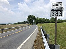
291:View north along MD 383 at MD 180 in Jefferson
618:(Map). Baltimore: Maryland Geological Survey.
574:(Map). Baltimore: Maryland Geological Survey.
8:
343:
205:
744:
741:Template:Attached KML/Maryland Route 383
697:Maryland State Roads Commission (1954).
653:Maryland State Roads Commission (1946).
16:State highway in Maryland, United States
674:"NBI Structure Number: 100000100087010"
485:. Maryland State Highway Administration
466:
18:
411:
405:
379:
373:
44:Maryland Route 383 highlighted in red
7:
770:Roads in Frederick County, Maryland
609:Maryland Geological Survey (1935).
568:Maryland Geological Survey (1930).
356:
14:
449:
412:
380:
226:
211:
106:
87:
66:5.48 mi (8.82 km)
24:
700:Maryland: Official Highway Map
656:Maryland: Official Highway Map
1:
350:
420:(Burkittsville Road) –
786:
765:State highways in Maryland
482:Highway Location Reference
678:National Bridge Inventory
456:Maryland Roads portal
434:
429:
408:
402:
397:
376:
368:
363:
360:
355:
349:
346:
204:
169:
160:
121:
54:
42:
37:
388:(Jefferson Pike) –
306:Poffenberger Road Bridge
261:Broad Run Jefferson Road
38:Broad Run Jefferson Road
337:The entire route is in
174:Maryland highway system
292:
290:
255:in the U.S. state of
745:KML is from Wikidata
519:"Maryland Route 383"
298:Lewis Mill Complex
293:
245:Maryland Route 383
31:Maryland Route 383
440:
439:
430:Northern terminus
398:Southern terminus
283:Route description
242:
241:
238:
237:
50:Route information
777:
735:
708:
707:
705:
694:
688:
687:
685:
684:
670:
664:
663:
661:
650:
644:
643:
641:
640:
626:
620:
619:
617:
606:
600:
599:
597:
596:
582:
576:
575:
565:
559:
558:
556:
555:
541:
535:
534:
532:
531:
515:
509:
506:
504:
499:Frederick County
493:
491:
490:
476:
454:
453:
452:
416:
415:
384:
383:
358:
352:
344:
339:Frederick County
234:
230:
229:
219:
215:
214:
206:
110:
109:
91:
90:
28:
19:
785:
784:
780:
779:
778:
776:
775:
774:
755:
754:
750:MDRoads: MD 383
746:
743:
738:
737:
736:
720:
716:
711:
703:
696:
695:
691:
682:
680:
672:
671:
667:
659:
652:
651:
647:
638:
636:
628:
627:
623:
615:
608:
607:
603:
594:
592:
584:
583:
579:
567:
566:
562:
553:
551:
543:
542:
538:
529:
527:
517:
516:
512:
502:
496:
488:
486:
478:
477:
468:
464:
450:
448:
445:
436:
413:
381:
353:
335:
322:
285:
227:
225:
212:
210:
107:
88:
79:Major junctions
45:
33:
32:
29:
17:
12:
11:
5:
783:
781:
773:
772:
767:
757:
756:
753:
752:
719:
718:
717:
715:
714:External links
712:
710:
709:
689:
665:
645:
621:
601:
577:
560:
536:
510:
508:
507:
465:
463:
460:
459:
458:
444:
441:
438:
437:
432:
431:
428:
410:
407:
404:
400:
399:
396:
378:
375:
372:
366:
365:
362:
359:
354:
348:
334:
331:
327:U.S. Route 340
321:
318:
302:Catoctin Creek
284:
281:
240:
239:
236:
235:
222:
220:
202:
201:
200:
199:
194:
189:
184:
178:
177:
167:
166:
165:Highway system
162:
161:
158:
157:
152:
148:
147:
142:
138:
137:
132:
128:
127:
123:
122:
119:
118:
104:
103:North end
100:
99:
85:
84:South end
81:
80:
76:
75:
72:
68:
67:
64:
60:
59:
55:Maintained by
52:
51:
47:
46:
43:
40:
39:
35:
34:
30:
23:
22:
15:
13:
10:
9:
6:
4:
3:
2:
782:
771:
768:
766:
763:
762:
760:
751:
748:
747:
742:
733:
729:
725:
724:
713:
702:
701:
693:
690:
679:
675:
669:
666:
658:
657:
649:
646:
634:
633:
625:
622:
614:
613:
605:
602:
590:
589:
581:
578:
573:
572:
564:
561:
549:
548:
540:
537:
526:
525:
520:
514:
511:
501:
500:
495:
494:
484:
483:
475:
473:
471:
467:
461:
457:
447:
446:
442:
433:
427:
423:
422:Burkittsville
419:
401:
395:
391:
387:
371:
367:
345:
342:
340:
333:Junction list
332:
330:
328:
319:
317:
315:
311:
307:
303:
299:
289:
282:
280:
278:
277:Burkittsville
274:
270:
266:
262:
258:
254:
253:state highway
250:
246:
233:
223:
221:
218:
208:
207:
203:
198:
197:Scenic Byways
195:
193:
190:
188:
185:
183:
180:
179:
176:
175:
171:
170:
168:
163:
159:
156:
153:
149:
146:
143:
139:
136:
135:United States
133:
129:
124:
120:
117:
116:Burkittsville
113:
105:
101:
98:
94:
86:
82:
77:
73:
69:
65:
61:
58:
53:
48:
41:
36:
27:
20:
721:
699:
692:
681:. Retrieved
677:
668:
655:
648:
637:. Retrieved
631:
624:
611:
604:
593:. Retrieved
587:
580:
570:
563:
552:. Retrieved
546:
539:
528:. Retrieved
522:
513:
498:
487:. Retrieved
481:
361:Destinations
336:
323:
294:
260:
259:. Known as
248:
244:
243:
172:
74:1930–present
524:Google Maps
759:Categories
683:2011-03-30
639:2011-03-30
595:2011-03-30
554:2011-03-30
530:2011-03-30
489:2011-03-30
462:References
426:Middletown
314:Middletown
182:Interstate
394:Brunswick
390:Jefferson
370:Jefferson
310:Broad Run
271:north to
269:Jefferson
155:Frederick
97:Jefferson
723:KML file
443:See also
347:Location
257:Maryland
151:Counties
145:Maryland
126:Location
521:(Map).
403:
320:History
251:) is a
131:Country
71:Existed
386:MD 180
265:MD 180
249:MD 383
232:MD 384
217:MD 382
93:MD 180
63:Length
704:(PDF)
660:(PDF)
616:(PDF)
503:(PDF)
418:MD 17
364:Notes
275:near
273:MD 17
192:State
141:State
114:near
112:MD 17
57:MDSHA
732:help
728:edit
409:8.82
406:5.48
377:0.00
374:0.00
267:in
95:in
761::
730:•
676:.
469:^
424:,
392:,
357:km
351:mi
341:.
316:.
224:→
209:←
187:US
734:)
726:(
686:.
642:.
598:.
557:.
533:.
505:.
492:.
247:(
Text is available under the Creative Commons Attribution-ShareAlike License. Additional terms may apply.