206:
52:
59:
360:, who occupy the Cunhã-Sapucaia Indigenous Territory adjacent to the east of the park, with an innovative model of sharing management of the park with the indigenous people. A zone of special indigenous use was defined in the management plan. The management plan was approved on 22 July 2014. As of 2016 the park was supported by the
373:
fishing lakes in the Igapó-Acu
Sustainable Development Reserve. The Mura claimed they should be recognised as historical protectors of the Matupiri river basin and users of its natural resources. When monitoring of the park began in 2011 traces of Mura presence were indeed found, including house structures, wood work areas and
409:
Peru had defined relevant principles. To avoid ongoing conflicts and to recognise the conservation role of the Mura people, the management plan recognised the
Indigenous Special Use Zone (ZUEI) in the park, basically consisting of land along the major rivers and streams upstream from the indigenous territory.
408:
and honey. They have also used it for fishing, and have acted as guides for sports fishing tourists. Creation of the park has caused a drop by almost 50% of tourism revenue. There was no legal precedent in Brazil for allowing indigenous people to use the resources of a state park, but
Colombia and
372:
The Mura people occupy the Cunhã-Sapucaia
Indigenous Territory lower down along the Matupiri River, the primary route for accessing the park. The 2006 study of the creation of the Matupiri Igapó-Açu Mosaic of Conservation Areas did not account for these people, who were noted only for "invading"
307:
Two possibly new species of fish have been identified and three possibly new species of herpetofauna. There are six species of birds endemic to the Purus-Madeira inter-fluvial. There are healthy populations of species that are extensively hunted such as
300:, without gallery forest. The savannah/campina area is ecologically very important, holding species unique to this type of environment. As of 2005 just 407 hectares (1,010 acres) had been deforested, or 0.08% of the total area. No further
249:
rivers. The
Matupiri river runs through the centre of the park from southwest to northeast, and provides the main way to access the interior of the park. To the southeast it adjoins the
642:
286:
258:
647:
254:
290:
250:
606:
262:
96:
652:
361:
51:
278:
565:
356:
Matupiri State Park was created by
Amazonas state decree 28424 of 27 March 2009. The park was created with participation of the
637:
253:. To the south it adjoins the PAE Jenipapo settlement. To the southwest it is bounded by the AM-464 highway, and borders the
33:
564:
Paulo Amaral; Andréia Pinto; Izabella da Paixão Gomes; Carlos
Alexandre da Cunha; Rodney Salomão; Gabriela Galetti (2012),
261:, which contains the zone affected by BR-319. To the northeast it adjoins the Cunhã-Sapucaia Indigenous Territory and the
226:(90.05%) in the state of Amazonas. It has an area of 513,747 hectares (1,269,500 acres). The park is to the south of the
189:, Brazil. It protects a rich area of Amazon rainforest and an ecologically important area of woodland savanna along the
296:
The park is 91% covered by dense lowland rainforest with emergent canopy, and 7% by grassy wooded savanna, or Amazon
282:
186:
632:
473:
317:
309:
182:
174:
139:
205:
532:
341:
380:
The Mura have traditionally used the park as a source of wood for their homes and boats, and of
325:
193:. Unusually for a state park, it includes an "indigenous special use zone" that allows the
297:
219:
511:
509:
273:
The park is part of an important ecological corridor in the region between the Purus and
246:
242:
190:
626:
301:
274:
238:
37:
197:
to continue to fish and extract forest products, as they have for many generations.
333:
484:
482:
605:
Sakagawa, Sergio; Pereira dos Santos & Stancik, Henrique; Franzen, Juliane,
357:
234:
223:
194:
83:
164:
Secretaria de Estado de Meio
Ambiente e Desenvolvimento Sustentável do Amazonas
445:
443:
441:
439:
437:
435:
433:
381:
393:
111:
98:
548:
515:
405:
389:
589:
385:
576:
401:
397:
227:
608:
Deposition: Indigenous special use zone in
Matupiri State Park (AM)
293:
and Rio Amapá Sustainable
Development Reserve near the Madeira.
461:
230:
highway. It is in the Médio Madeira microregion of Amazonas.
218:
Matupiri State Park is divided between the municipalities of
500:
516:
Sakagawa, Pereira dos Santos & Stancik & Franzen
281:, Apurinã do Igarapé Tauamirim Indigenous Territory,
209:
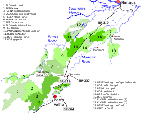
Conservation units in the Purus-Madeira interfluvial.
160:
145:
135:
127:
90:
79:
71:
21:
488:
449:
424:
594:(in Portuguese), ISA: Instituto Socioambiental
553:(in Portuguese), ISA: Instituto Socioambiental
643:Protected areas of Amazonas (Brazilian state)
573:Áreas Protegidas no Sul do Estado do Amazonas
287:Piagaçu-Purus Sustainable Development Reserve
8:
251:Rio Madeira Sustainable Development Reserve
241:inter-fluvial region, in the basins of the
58:
18:
259:Igapó-Açu Sustainable Development Reserve
255:Rio Amapá Sustainable Development Reserve
291:Lago do Capanã Grande Extractive Reserve
263:Matupiri Sustainable Development Reserve
204:
417:
377:vegetation in early succession stages.
362:Amazon Region Protected Areas Program
7:
279:Nascentes do Lago Jari National Park
70:
648:Protected areas established in 2009
304:was observed from then until 2010.
462:PARNA Nascentes do Lago Jari – ISA
131:513,747 hectares (1,269,500 acres)
14:
534:Full list: PAs supported by ARPA
501:Full list: PAs supported by ARPA
57:
50:
277:rivers in combination with the
144:
78:
257:. To the north it borders the
1:
653:2009 establishments in Brazil
566:"Parque Estadual do Matupiri"
575:(in Portuguese), Belém, PA:
550:PARNA Nascentes do Lago Jari
368:Indigenous special use zone
289:on the Purus River and the
179:Parque Estadual do Matupiri
27:Parque Estadual do Matupiri
669:
283:Abufari Biological Reserve
45:
31:
26:
474:Paulo Amaral et al. 2012
149:March 27, 2009
215:
178:
638:State parks of Brazil
491:, Historico Juridico.
489:PES do Matupiri – ISA
450:PES do Matupiri – ISA
427:, Informações gerais.
425:PES do Matupiri – ISA
214:. Matupiri State Park
208:
112:5.22223°S 61.314489°W
318:white-lipped peccary
310:South American tapir
117:-5.22223; -61.314489
16:State park in Brazil
233:The park is in the
171:Matupiri State Park
108: /
22:Matupiri State Park
452:, Características.
342:gray woolly monkey
314:Tapirus terrestris
216:
168:
167:
80:Nearest city
660:
633:IUCN Category II
618:
617:
616:
601:
600:
599:
585:
584:
583:
570:
560:
559:
558:
544:
543:
542:
519:
513:
504:
498:
492:
486:
477:
471:
465:
459:
453:
447:
428:
422:
326:collared peccary
185:in the state of
156:
154:
123:
122:
120:
119:
118:
113:
109:
106:
105:
104:
101:
61:
60:
54:
19:
668:
667:
663:
662:
661:
659:
658:
657:
623:
622:
621:
614:
612:
604:
597:
595:
591:PES do Matupiri
588:
581:
579:
568:
563:
556:
554:
547:
540:
538:
531:
527:
522:
514:
507:
499:
495:
487:
480:
472:
468:
460:
456:
448:
431:
423:
419:
415:
370:
354:
271:
210:
203:
152:
150:
116:
114:
110:
107:
102:
99:
97:
95:
94:
67:
66:
65:
64:
63:
62:
41:
17:
12:
11:
5:
666:
664:
656:
655:
650:
645:
640:
635:
625:
624:
620:
619:
602:
586:
561:
545:
528:
526:
523:
521:
520:
505:
493:
478:
466:
454:
429:
416:
414:
411:
369:
366:
353:
350:
346:Lagothrix cana
322:Tayassu pecari
270:
267:
202:
199:
191:Matupiri River
166:
165:
162:
158:
157:
147:
143:
142:
137:
133:
132:
129:
125:
124:
92:
88:
87:
81:
77:
76:
73:
69:
68:
56:
55:
49:
48:
47:
46:
43:
42:
32:
29:
28:
24:
23:
15:
13:
10:
9:
6:
4:
3:
2:
665:
654:
651:
649:
646:
644:
641:
639:
636:
634:
631:
630:
628:
610:
609:
603:
593:
592:
587:
578:
574:
567:
562:
552:
551:
546:
536:
535:
530:
529:
524:
517:
512:
510:
506:
502:
497:
494:
490:
485:
483:
479:
476:, p. 47.
475:
470:
467:
463:
458:
455:
451:
446:
444:
442:
440:
438:
436:
434:
430:
426:
421:
418:
412:
410:
407:
403:
399:
395:
391:
387:
383:
378:
376:
367:
365:
363:
359:
351:
349:
347:
343:
340:species) and
339:
335:
331:
330:Pecari tajacu
327:
323:
319:
315:
311:
305:
303:
302:deforestation
299:
294:
292:
288:
284:
280:
276:
268:
266:
264:
260:
256:
252:
248:
244:
240:
236:
231:
229:
225:
221:
213:
207:
200:
198:
196:
192:
188:
184:
180:
176:
172:
163:
161:Administrator
159:
148:
141:
138:
134:
130:
126:
121:
93:
89:
85:
82:
74:
53:
44:
39:
38:national park
35:
34:IUCN category
30:
25:
20:
613:, retrieved
607:
596:, retrieved
590:
580:, retrieved
572:
555:, retrieved
549:
539:, retrieved
533:
496:
469:
457:
420:
379:
374:
371:
355:
345:
337:
334:brocket deer
329:
321:
313:
306:
295:
272:
232:
222:(9.95%) and
217:
211:
170:
169:
382:Brazil nuts
269:Environment
195:Mura people
136:Designation
115: /
91:Coordinates
627:Categories
615:2016-09-01
598:2016-09-01
582:2016-09-01
557:2016-06-02
541:2016-08-07
413:References
384:, lianas,
183:state park
175:Portuguese
153:2009-03-27
140:State park
103:61°18′52″W
86:, Amazonas
100:5°13′20″S
390:andiroba
375:capoeira
243:Matupiri
224:Manicoré
201:Location
187:Amazonas
84:Manicoré
72:Location
525:Sources
386:copaiba
352:History
298:campina
275:Madeira
239:Madeira
181:) is a
151: (
146:Created
577:Imazon
537:, ARPA
406:patauá
402:bacaba
398:buriti
392:oils,
338:Mazama
228:BR-319
75:Brazil
611:, ISA
569:(PDF)
285:and
247:Amapá
235:Purus
220:Borba
394:açaí
388:and
358:Mura
245:and
128:Area
36:II (
348:).
332:),
324:),
316:),
629::
571:,
508:^
481:^
432:^
404:,
400:,
396:,
364:.
265:.
237:-
212:16
177::
518:.
503:.
464:.
344:(
336:(
328:(
320:(
312:(
173:(
155:)
40:)
Text is available under the Creative Commons Attribution-ShareAlike License. Additional terms may apply.