28:
20:
371:
396:
332:
391:
148:
94:
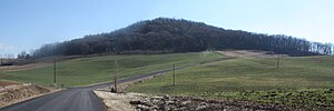
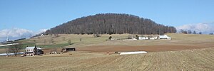
in an otherwise relatively flat valley, surrounded by farmland. The peak of Mole Hill is approximately 1,893 feet (577 meters) above sea level.
166:
Tioga
Bentonite, but discovered that the rocks were actually a much younger age of approximately 47 million years, placing them in the
227:
189:
376:
290:
Fullagar, Paul D.; Bottino, Michael L. (1969). "Tertiary
Felsite Intrusions in the Valley and Ridge Province, Virginia".
77:
322:
381:
386:
177:
156:
303:
180:, is geologically similar to Mole Hill and thought to be contemporaneous with it, along with other intrusive
101:
outcropping at the crest of the hill is "dark greenish gray to grayish black, medium grained, and moderately
218:
Jonathan L. Tso; Ronald R. McDowell; Katharine Lee Avary; David L. Matchen & Gerald P. Wilkes (2004).
152:
69:
241:
271:. Commonwealth of Virginia, Dept. of Mines, Minerals, and Energy, Division of Mineral Resources.
159:
102:
64:
approximately 47 million years ago, making it one of the youngest volcanoes on the east coast of
272:
128:
219:
299:
57:
50:
140:
365:
193:
185:
65:
43:
220:"Middle Eocene Igneous Rocks in the Valley and Ridge of Virginia and West Virginia"
173:
266:
125:
121:
347:
334:
276:
144:
90:
54:
27:
19:
162:
techniques to date rocks that they thought were temporally related to the
163:
114:
73:
181:
118:
106:
61:
167:
110:
98:
47:
39:
26:
18:
268:
Geology of the
Harrisonburg and Bridgewater quadrangles, Virginia
242:"Mole Hill Topo Map, Rockingham County VA (Bridgewater Area)"
304:
10.1130/0016-7606(1969)80[1853:TFIITV]2.0.CO;2
16:Hill and Extinct volcano in Harrisonburg, Virginia
265:Gathright, Thomas M; Frischmann, Peter S (1986).
60:. It is the eroded remnant of what was an active
88:Mole Hill is an isolated, rounded, tree-covered
323:"A Brief Geologic History Of Rockingham County"
143:in the area) was originally thought to be of
8:
139:The basalt at Mole Hill (and other igneous
372:Landforms of Rockingham County, Virginia
205:
292:Geological Society of America Bulletin
213:
211:
209:
113:basalt with abundant large pale green
151:. In 1969, Fullagar and Bottino used
31:View facing northwest from Swope Road
7:
124:." The basalt intrudes through the
23:View facing east from Mole Hill Road
397:Volcanic plugs of the United States
14:
392:Cinder cones of the United States
147:age by relative age dating using
228:United States Geological Survey
38:is a rounded hill composed of
1:
325:. James Madison University.
149:cross-cutting relationships
413:
68:. It is located west of
117:and minor yellow-brown
32:
24:
377:Volcanoes of Virginia
348:38.44861°N 78.95333°W
321:Sherwood, W. Cullen.
30:
22:
131:of carbonate rocks.
46:, formed during the
353:38.44861; -78.95333
344: /
160:radiometric dating
33:
25:
382:Hills of Virginia
129:Beekmantown Group
78:Rockingham County
404:
387:Eocene volcanoes
359:
358:
356:
355:
354:
349:
345:
342:
341:
340:
337:
326:
308:
307:
287:
281:
280:
262:
256:
255:
253:
252:
238:
232:
231:
215:
190:Pendleton County
412:
411:
407:
406:
405:
403:
402:
401:
362:
361:
352:
350:
346:
343:
338:
335:
333:
331:
330:
320:
317:
312:
311:
289:
288:
284:
264:
263:
259:
250:
248:
240:
239:
235:
217:
216:
207:
202:
178:Highland County
137:
86:
17:
12:
11:
5:
410:
408:
400:
399:
394:
389:
384:
379:
374:
364:
363:
328:
327:
316:
315:External links
313:
310:
309:
282:
257:
233:
204:
203:
201:
198:
136:
133:
85:
82:
15:
13:
10:
9:
6:
4:
3:
2:
409:
398:
395:
393:
390:
388:
385:
383:
380:
378:
375:
373:
370:
369:
367:
360:
357:
324:
319:
318:
314:
305:
301:
297:
293:
286:
283:
278:
274:
270:
269:
261:
258:
247:
243:
237:
234:
229:
225:
224:Circular 1264
221:
214:
212:
210:
206:
199:
197:
195:
194:West Virginia
191:
187:
186:Ugly Mountain
183:
179:
176:, located in
175:
171:
169:
165:
161:
158:
154:
150:
146:
142:
134:
132:
130:
127:
123:
120:
116:
112:
108:
104:
100:
95:
93:
92:
83:
81:
79:
75:
71:
67:
66:North America
63:
59:
56:
52:
49:
45:
44:volcanic rock
41:
37:
29:
21:
329:
295:
291:
285:
267:
260:
249:. Retrieved
245:
236:
223:
174:Trimble Knob
172:
138:
96:
89:
87:
70:Harrisonburg
35:
34:
351: /
298:(9): 1853.
184:rocks near
122:phenocrysts
105:. It is an
103:porphyritic
84:Description
366:Categories
339:78°57′12″W
336:38°26′55″N
251:2018-06-11
200:References
126:Ordovician
277:758391284
145:Paleozoic
91:monadnock
55:Paleogene
36:Mole Hill
246:TopoZone
164:Devonian
115:pyroxene
74:Virginia
182:igneous
119:olivine
107:olivine
62:volcano
53:of the
275:
168:Eocene
111:spinel
99:basalt
58:period
48:Eocene
40:basalt
157:Rb-Sr
141:dikes
76:, in
51:epoch
273:OCLC
155:and
153:K-Ar
97:The
42:, a
300:doi
188:in
135:Age
368::
296:80
294:.
244:.
226:.
222:.
208:^
196:.
192:,
170:.
80:.
72:,
306:.
302::
279:.
254:.
230:.
109:-
Text is available under the Creative Commons Attribution-ShareAlike License. Additional terms may apply.