20:
32:
116:, a partnership between Benin and Togo completed in 1987. Studies have reported economic benefits from the dam, including tourism and fishing in the lake behind it. The dam's construction displaced between 7,600 and 10,000 people, however, and studies indicate that it has substantially modified the ecology of the lagoon system at the river's mouth by reducing the natural seasonal fluctuations in river flow. A second dam project,
132:
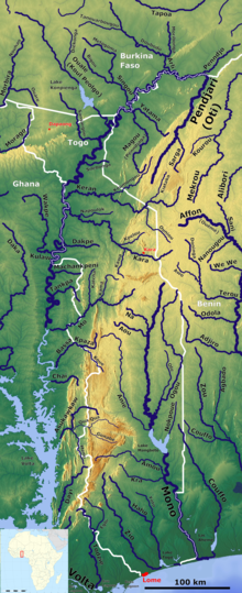
About 35 km (22 mi) from its mouth, there are six series of rapids. Below this, the river becomes slow-moving and flows over a swampy floodplain, and there is a large area of contiguous wetland in both Togo and Benin. This area has a rich growth of reeds, sedges and grasses, and
124:
agreed to support the project. The dam's construction is part of the government's plan to increase Benin's domestic power generation capacity from 20 to 70% as most of Togo and Benin's electricity currently needs to be imported from the
396:
342:
450:
120:, was proposed to be built on the river between Nangbeto and the river's mouth during the 1990s but did not receive financing until 2017 when the
54:
Approximately 400 km (250 mi) long, and draining a basin of about 20,000 km (7,700 sq mi), it rises between the town of
290:
263:
313:
Thomas, Kevin (2002). Development projects and involuntary population displacement: The World Bank's attempt to correct past failures.
238:
213:
171:
445:
121:
335:
305:
85:. Only the part of the river nearest its mouth is navigable. Most of the river's basin on the upper tableland is
440:
435:
328:
363:
351:
239:
https://www.togofirst.com/en/investments/1109-1578-togo-cad-fund-to-support-new-development-projects
19:
117:
286:
280:
259:
167:
63:
62:, and flows south. Along the southern portion of the river towards its mouth, it forms the
31:
94:
237:, Togo: CAD Fund to support new development projects, Tuesday, 11 September 2018 19:08,
71:
67:
429:
142:
126:
113:
187:
24:
411:
398:
381:
255:
138:
82:
36:
55:
371:
304:
Adam, K.S (1991). Les impacts environnementaux du barrage du
Nangbeto.
134:
106:
86:
102:
74:
112:
The river is dammed 160 km (99 mi) from its mouth by the
90:
59:
30:
18:
320:
355:
98:
78:
48:
324:
214:"Multinational: Nangbeto Hydroelectric Dam (Benin/Togo)"
362:
66:between Togo and Benin. The river drains into the
216:. African Development Bank Group. 15 January 2014
336:
8:
343:
329:
321:
154:
315:Population Research and Policy Review
7:
166:. Reed International. p. 101.
39:(north) and the Mono River (south)
14:
282:A Directory of African Wetlands
252:Africa South of the Sahara 2014
70:through an extensive system of
451:International rivers of Africa
47:is the major river of eastern
1:
122:China-Africa Development Fund
250:Europa Publications (2014).
16:Major river of eastern Togo
467:
194:. Encyclopædia Britannica
23:Mono River mouth area in
192:Encyclopædia Britannica
64:international boundary
40:
28:
285:. IUCN. p. 443.
279:Hughes, R.H. (1992).
34:
22:
145:occur in the river.
58:and the border with
408: /
164:Atlas of the World
41:
29:
446:Benin–Togo border
412:6.2959°N 1.9299°E
390:
389:
292:978-2-88032-949-5
265:978-1-85743-698-3
162:Philip's (1994).
458:
423:
422:
420:
419:
418:
413:
409:
406:
405:
404:
401:
345:
338:
331:
322:
310:13(1-4):103-112.
297:
296:
276:
270:
269:
247:
241:
232:
226:
225:
223:
221:
210:
204:
203:
201:
199:
184:
178:
177:
159:
466:
465:
461:
460:
459:
457:
456:
455:
441:Rivers of Benin
426:
425:
416:
414:
410:
407:
402:
399:
397:
395:
394:
393:
391:
386:
358:
349:
301:
300:
293:
278:
277:
273:
266:
258:. p. 112.
249:
248:
244:
233:
229:
219:
217:
212:
211:
207:
197:
195:
186:
185:
181:
174:
161:
160:
156:
151:
17:
12:
11:
5:
464:
462:
454:
453:
448:
443:
438:
436:Rivers of Togo
428:
427:
417:6.2959; 1.9299
388:
387:
385:
384:
379:
374:
368:
366:
360:
359:
350:
348:
347:
340:
333:
325:
319:
318:
317:21(4):339-349.
311:
299:
298:
291:
271:
264:
242:
227:
205:
179:
172:
153:
152:
150:
147:
72:brackish water
68:Bight of Benin
35:Togo with the
15:
13:
10:
9:
6:
4:
3:
2:
463:
452:
449:
447:
444:
442:
439:
437:
434:
433:
431:
424:
421:
383:
380:
378:
375:
373:
370:
369:
367:
365:
361:
357:
353:
346:
341:
339:
334:
332:
327:
326:
323:
316:
312:
309:
308:
303:
302:
294:
288:
284:
283:
275:
272:
267:
261:
257:
253:
246:
243:
240:
236:
231:
228:
215:
209:
206:
193:
189:
183:
180:
175:
173:0-540-05831-9
169:
165:
158:
155:
148:
146:
144:
140:
136:
130:
128:
123:
119:
115:
110:
108:
104:
100:
96:
92:
88:
84:
80:
76:
73:
69:
65:
61:
57:
52:
50:
46:
38:
33:
26:
21:
392:
376:
314:
307:Geo-Eco-Trop
306:
281:
274:
251:
245:
234:
230:
218:. Retrieved
208:
196:. Retrieved
191:
188:"Mono River"
182:
163:
157:
143:hippopotamus
131:
127:Akosombo Dam
118:Adjarala Dam
114:Nangbeto Dam
111:
81:, including
53:
44:
42:
27:area, Benin.
415: /
220:21 November
198:21 November
430:Categories
235:Togo First
149:References
139:crocodiles
129:in Ghana.
87:cultivated
45:Mono River
25:Grand-Popo
403:1°55′48″E
400:6°17′45″N
256:Routledge
83:Lake Togo
37:Oti River
135:manatees
107:cassava
75:lagoons
364:Rivers
352:Rivers
289:
262:
170:
103:cotton
56:Sokodé
91:maize
79:lakes
60:Benin
377:Mono
356:Togo
287:ISBN
260:ISBN
222:2016
200:2016
168:ISBN
141:and
105:and
99:rice
95:yams
89:for
77:and
49:Togo
43:The
382:Oti
354:of
432::
372:Mo
254:.
190:.
137:,
109:.
101:,
97:,
93:,
51:.
344:e
337:t
330:v
295:.
268:.
224:.
202:.
176:.
Text is available under the Creative Commons Attribution-ShareAlike License. Additional terms may apply.