Name on the Register
Image
Date listed
Location
City or town
Description
1
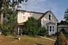
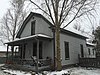
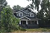
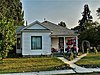
Allison-Reinkeh House Allison-Reinkeh House August 26, 1988 (#88001280 ) 207 Adirondac St. 46°15′17″N 114°09′29″W / 46.254722°N 114.158056°W / 46.254722; -114.158056 (Allison-Reinkeh House ) Hamilton part of the Hamilton MRA
2
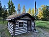
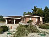
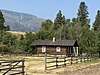
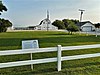
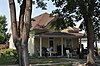
Alta Ranger Station Alta Ranger Station December 19, 1974 (#74001099 ) South of Conner in the Bitterroot National Forest 45°37′08″N 114°17′55″W / 45.618889°N 114.298611°W / 45.618889; -114.298611 (Alta Ranger Station ) Conner
3
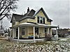
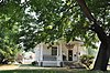
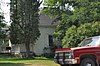
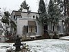
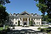
Bass Mansion Bass Mansion November 14, 1978 (#78001691 ) 216 N. College St. 46°30′43″N 114°05′20″W / 46.511944°N 114.088889°W / 46.511944; -114.088889 (Bass Mansion ) Stevensville
4
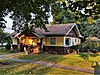
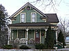
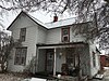
Daniel V. Bean House Daniel V. Bean House August 26, 1988 (#88001288 ) 611 N. 2nd 46°15′10″N 114°09′27″W / 46.252778°N 114.1575°W / 46.252778; -114.1575 (Daniel V. Bean House ) Hamilton part of the Hamilton MRA
5
Big Creek Lake Site Upload image May 17, 1976 (#76001127 ) Address restricted Stevensville
6
Bitter Root Cooperative Creamery Bitter Root Cooperative Creamery June 19, 1991 (#91000726 ) 3730 Eastside Highway 46°30′44″N 114°04′54″W / 46.512222°N 114.081667°W / 46.512222; -114.081667 (Bitter Root Cooperative Creamery ) Stevensville part of the Stevensville MRA
7
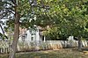
Oliver Blood House Oliver Blood House August 26, 1988 (#88001279 ) 524 S. 1st St. 46°14′33″N 114°09′13″W / 46.2425°N 114.153611°W / 46.2425; -114.153611 (Oliver Blood House ) Hamilton part of the Hamilton MRA
8
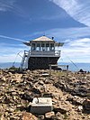
Boulder Point Lookout Boulder Point Lookout November 10, 1980 (#100002044 ) 2 miles (3.2 km) NW of West Fork Ranger Station 45°50′16″N 114°17′21″W / 45.837782°N 114.289085°W / 45.837782; -114.289085 (Boulder Point Lookout ) Darby vicinity
9
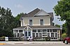
Brooks Hotel Brooks Hotel November 10, 1980 (#80002430 ) Off the East Side Highway 46°18′46″N 114°06′44″W / 46.312778°N 114.112222°W / 46.312778; -114.112222 (Brooks Hotel ) Corvallis
10
Charles Amos Buck House Charles Amos Buck House June 18, 1991 (#91000727 ) 211 Buck St. 46°30′37″N 114°05′38″W / 46.510278°N 114.093889°W / 46.510278; -114.093889 (Charles Amos Buck House ) Stevensville part of the Stevensville MRA
11
Fred Buck House Fred Buck House June 18, 1991 (#91000729 ) 217 Buck St. 46°30′36″N 114°05′39″W / 46.51°N 114.094167°W / 46.51; -114.094167 (Fred Buck House ) Stevensville part of the Stevensville MRA
12
Canyon Creek Laboratory of the U.S. Public Health Service Canyon Creek Laboratory of the U.S. Public Health Service October 15, 1970 (#70000362 ) West of Hamilton city limits 46°15′15″N 114°10′49″W / 46.254167°N 114.180278°W / 46.254167; -114.180278 (Canyon Creek Laboratory of the U.S. Public Health Service ) Hamilton Altered and now home to the Hamilton Players Theater.
13
W.T. Caple House W.T. Caple House June 19, 1991 (#91000730 ) 210 Church St. 46°30′37″N 114°05′28″W / 46.510278°N 114.091111°W / 46.510278; -114.091111 (W.T. Caple House ) Stevensville part of the Stevensville MRA
14
Jennie Clark House Jennie Clark House June 19, 1991 (#91000731 ) 423 Pine St. 46°30′25″N 114°05′21″W / 46.506944°N 114.089167°W / 46.506944; -114.089167 (Jennie Clark House ) Stevensville part of the Stevensville MRA
15
William Cochran House William Cochran House June 19, 1991 (#91000732 ) 3713 East Side Highway 46°30′46″N 114°05′00″W / 46.512778°N 114.083333°W / 46.512778; -114.083333 (William Cochran House ) Stevensville part of the Stevensville MRA
16
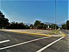
Como School Como School November 22, 2022 (#100008424 ) Jct. of Old Darby Rd. and US 93 46°05′27″N 114°10′33″W / 46.0907°N 114.1758°W / 46.0907; -114.1758 (Como School ) Darby vicinity
17
Conway House Conway House August 26, 1988 (#88001291 ) 805 S. 4th St. 46°14′20″N 114°09′32″W / 46.238889°N 114.158889°W / 46.238889; -114.158889 (Conway House ) Hamilton part of the Hamilton MRA
18
Calvin and Maggie Cook House Calvin and Maggie Cook House June 19, 1991 (#91000734 ) 501 Main St. 46°30′24″N 114°05′36″W / 46.506667°N 114.093333°W / 46.506667; -114.093333 (Calvin and Maggie Cook House ) Stevensville part of the Stevensville MRA
19
Wilbur Cook House Wilbur Cook House June 19, 1991 (#91000733 ) 3717 East Side Highway 46°30′46″N 114°04′59″W / 46.512778°N 114.083056°W / 46.512778; -114.083056 (Wilbur Cook House ) Stevensville part of the Stevensville MRA
20
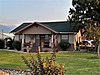
Martin Cramer House Martin Cramer House August 3, 1987 (#87001259 ) 326 Groff La. 46°25′32″N 114°04′51″W / 46.425556°N 114.080833°W / 46.425556; -114.080833 (Martin Cramer House ) Stevensville
21
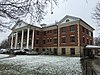
Marcus Daly Memorial Hospital Marcus Daly Memorial Hospital December 15, 1978 (#78001690 ) 211 S. 4th St. 46°14′43″N 114°09′34″W / 46.245278°N 114.159444°W / 46.245278; -114.159444 (Marcus Daly Memorial Hospital ) Hamilton
22
DeNayer House DeNayer House July 29, 1994 (#94000782 ) 327 Main St. 46°30′31″N 114°06′18″W / 46.508611°N 114.105°W / 46.508611; -114.105 (DeNayer House ) Stevensville part of the Stevensville MRA
23
F.H. Drinkenberg's First Home F.H. Drinkenberg's First Home August 26, 1988 (#88001289 ) 701 N. 2nd 46°15′12″N 114°09′27″W / 46.253333°N 114.1575°W / 46.253333; -114.1575 (F.H. Drinkenberg's First Home ) Hamilton part of the Hamilton MRA
24
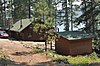
El Capitan Lodge El Capitan Lodge November 29, 1990 (#90001792 ) Access Rd. 1111 on the northern shore of Lake Como in the Bitterroot National Forest 46°03′56″N 114°14′42″W / 46.065556°N 114.245°W / 46.065556; -114.245 (El Capitan Lodge ) Hamilton
25
E.G. Ellis House E.G. Ellis House August 26, 1988 (#88001281 ) 801 N. 3rd 46°15′17″N 114°09′32″W / 46.254722°N 114.158889°W / 46.254722; -114.158889 (E.G. Ellis House ) Hamilton part of the Hamilton MRA
26
Emhoff House Emhoff House June 19, 1991 (#91000736 ) 401 Church St. 46°30′29″N 114°05′31″W / 46.508056°N 114.091944°W / 46.508056; -114.091944 (Emhoff House ) Stevensville part of the Stevensville MRA
27
Etna School Etna School May 30, 1997 (#97000504 ) 2853 Eastside Highway 46°25′59″N 114°05′39″W / 46.433056°N 114.094167°W / 46.433056; -114.094167 (Etna School ) Stevensville
28
First Baptist Church First Baptist Church September 3, 1991 (#91000737 ) 402 Church 46°30′29″N 114°05′30″W / 46.508056°N 114.091667°W / 46.508056; -114.091667 (First Baptist Church ) Stevensville part of the Stevensville MRA
29
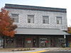
First State Bank, Dowling and Emhoff Buildings First State Bank, Dowling and Emhoff Buildings June 19, 1991 (#91000738 ) 300-304 and 306-308 Main St. 46°30′35″N 114°05′33″W / 46.509722°N 114.0925°W / 46.509722; -114.0925 (First State Bank, Dowling and Emhoff Buildings ) Stevensville part of the Stevensville MRA
30
Joseph Fisher House Joseph Fisher House June 19, 1991 (#91000739 ) 103 College St. 46°30′43″N 114°05′23″W / 46.511944°N 114.089722°W / 46.511944; -114.089722 (Joseph Fisher House ) Stevensville part of the Stevensville MRA
31
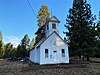
Fort Owen Fort Owen October 6, 1970 (#70000363 ) About 0.5 miles (0.80 km) northwest of Stevensville 46°31′10″N 114°05′49″W / 46.519444°N 114.097083°W / 46.519444; -114.097083 (Fort Owen ) Stevensville
32
Perry Foust House Perry Foust House June 19, 1991 (#91000740 ) 401 Mission St. 46°30′31″N 114°05′45″W / 46.508611°N 114.095833°W / 46.508611; -114.095833 (Perry Foust House ) Stevensville part of the Stevensville MRA; demolished.
33
Foye Rental Houses Foye Rental Houses August 26, 1988 (#88001292 ) 819 and 821 N. 4th 46°15′17″N 114°09′38″W / 46.254722°N 114.160556°W / 46.254722; -114.160556 (Foye Rental Houses ) Hamilton part of the Hamilton MRA
34
Charles Fulton House Charles Fulton House June 19, 1991 (#91000742 ) 377 5th St. 46°30′22″N 114°05′24″W / 46.506111°N 114.09°W / 46.506111; -114.09 (Charles Fulton House ) Stevensville part of the Stevensville MRA
35
Gavin House Gavin House June 19, 1991 (#91000743 ) 219 College St. 46°30′35″N 114°05′25″W / 46.509722°N 114.090278°W / 46.509722; -114.090278 (Gavin House ) Stevensville part of the Stevensville MRA
36
Sherman Gill House Sherman Gill House August 26, 1988 (#88001282 ) 605 N. 3rd 46°15′07″N 114°09′32″W / 46.251944°N 114.158889°W / 46.251944; -114.158889 (Sherman Gill House ) Hamilton part of the Hamilton MRA
37
Gird Point Lookout Gird Point Lookout April 6, 2018 (#100002297 ) Gird Pt., Sapphire Mts., Bitterroot NF 46°12′27″N 113°54′42″W / 46.207451°N 113.911538°W / 46.207451; -113.911538 (Gird Point Lookout ) Hamilton vicinity
38
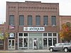
Gleason Building Gleason Building June 19, 1991 (#91000744 ) 200-202 Main St. 46°30′39″N 114°05′27″W / 46.510833°N 114.090833°W / 46.510833; -114.090833 (Gleason Building ) Stevensville part of the Stevensville MRA
39
Goff House Goff House August 26, 1988 (#88001283 ) 115 N. 5th 46°14′50″N 114°09′39″W / 46.247222°N 114.160833°W / 46.247222; -114.160833 (Goff House ) Hamilton part of the Hamilton MRA
40
Gordon House Gordon House August 26, 1988 (#88001294 ) 806 S. 4th 46°14′22″N 114°09′29″W / 46.239444°N 114.158056°W / 46.239444; -114.158056 (Gordon House ) Hamilton part of the Hamilton MRA
41
Charles Granke House Charles Granke House August 26, 1988 (#88001278 ) 406 S. 7th St. 46°14′36″N 114°09′45″W / 46.243333°N 114.1625°W / 46.243333; -114.1625 (Charles Granke House ) Hamilton part of the Hamilton MRA
42
Hamilton Commercial Historic District Hamilton Commercial Historic District September 1, 1988 (#88001273 ) Main, N. 2nd, S. 2nd, S. 3rd, and State Sts. 46°14′50″N 114°09′27″W / 46.247222°N 114.1575°W / 46.247222; -114.1575 (Hamilton Commercial Historic District ) Hamilton part of the Hamilton MRA
43
Hamilton Southside Residential Historic District Hamilton Southside Residential Historic District September 1, 1988 (#88001272 ) S. 1st, S. 2nd, S. 3rd, S. 4th, and S. 5th Sts. 46°14′35″N 114°09′27″W / 46.243056°N 114.1575°W / 46.243056; -114.1575 (Hamilton Southside Residential Historic District ) Hamilton part of the Hamilton MRA
44
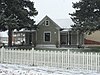
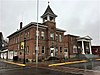
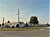
Hamilton Town Hall Hamilton Town Hall April 21, 1980 (#80002431 ) 175 S. 3rd St. 46°14′46″N 114°09′29″W / 46.246111°N 114.158056°W / 46.246111; -114.158056 (Hamilton Town Hall ) Hamilton Not the current city hall.
45
Rose Harrington House Rose Harrington House June 19, 1991 (#91000745 ) 3709 East Side Highway 46°30′46″N 114°05′00″W / 46.512778°N 114.083333°W / 46.512778; -114.083333 (Rose Harrington House ) Stevensville part of the Stevensville MRA
46
Hayward Lodge Hayward Lodge May 11, 2015 (#15000216 ) On L. Como 46°03′55″N 114°14′41″W / 46.0654°N 114.2446°W / 46.0654; -114.2446 (Hayward Lodge ) Bitterroot National Forest , Darby vicinityNow known as Wood's Cabin.
47
Charles Hoffman House Charles Hoffman House August 26, 1988 (#88001277 ) 807 S. 3rd 46°14′20″N 114°09′23″W / 46.238889°N 114.156389°W / 46.238889; -114.156389 (Charles Hoffman House ) Hamilton part of the Hamilton MRA
48
John G. Howe House John G. Howe House June 18, 1991 (#91000746 ) 215 Park Ave. 46°30′27″N 114°05′05″W / 46.5075°N 114.084722°W / 46.5075; -114.084722 (John G. Howe House ) Stevensville part of the Stevensville MRA
49
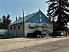
IOOF Hall IOOF Hall June 19, 1991 (#91000747 ) 217-219 Main St. 46°30′37″N 114°05′35″W / 46.510278°N 114.093056°W / 46.510278; -114.093056 (IOOF Hall ) Stevensville part of the Stevensville MRA
50
John Lagerquist House John Lagerquist House August 26, 1988 (#88001284 ) 701 N. 4th St. 46°15′12″N 114°09′37″W / 46.253333°N 114.160278°W / 46.253333; -114.160278 (John Lagerquist House ) Hamilton part of the Hamilton MRA
51
Lancaster House Lancaster House June 19, 1991 (#91000748 ) 407 3rd St. 46°30′33″N 114°05′16″W / 46.509167°N 114.087778°W / 46.509167; -114.087778 (Lancaster House ) Stevensville part of the Stevensville MRA
52
John A. Landram House John A. Landram House March 14, 1996 (#91000749 ) 113 College St. 46°30′42″N 114°05′11″W / 46.511667°N 114.086389°W / 46.511667; -114.086389 (John A. Landram House ) Stevensville part of the Stevensville MRA
53
Lockridge House Lockridge House June 19, 1991 (#91000750 ) 301 Mission St. 46°30′35″N 114°04′57″W / 46.509722°N 114.0825°W / 46.509722; -114.0825 (Lockridge House ) Stevensville part of the Stevensville MRA
54
Lost Horse Fireman's Cabin (24RA197) Upload image April 17, 1989 (#88003437 ) Off Lost Horse Rd. near Bear Creek Pass 46°07′50″N 114°29′33″W / 46.130556°N 114.4925°W / 46.130556; -114.4925 (Lost Horse Fireman's Cabin (24RA197) ) Darby
55
Albert May House Albert May House June 18, 1991 (#91000751 ) 218 Church St. 46°30′36″N 114°05′27″W / 46.51°N 114.090833°W / 46.51; -114.090833 (Albert May House ) Stevensville part of the Stevensville MRA
56
Charles May House Charles May House June 18, 1991 (#91000753 ) 109 Church St. 46°30′43″N 114°05′28″W / 46.511944°N 114.091111°W / 46.511944; -114.091111 (Charles May House ) Stevensville part of the Stevensville MRA
57
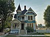
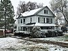
George May House George May House October 25, 1982 (#82000596 ) 100 Park Ave. 46°30′32″N 114°05′01″W / 46.508889°N 114.083611°W / 46.508889; -114.083611 (George May House ) Stevensville
58
Harry May House Harry May House June 18, 1991 (#91000752 ) 526 3rd St. 46°30′34″N 114°05′04″W / 46.509444°N 114.084444°W / 46.509444; -114.084444 (Harry May House ) Stevensville part of the Stevensville MRA
59
Louis May House Louis May House June 19, 1991 (#91000754 ) 100 Church St. 46°30′44″N 114°05′26″W / 46.512222°N 114.090556°W / 46.512222; -114.090556 (Louis May House ) Stevensville part of the Stevensville MRA
60
McCart Fire Lookout Upload image June 19, 1996 (#96000660 ) Approximately 4 miles (6.4 km) south of the East Fork Forest Service Station in Bitterroot National Forest 45°53′05″N 113°43′00″W / 45.884722°N 113.716667°W / 45.884722; -113.716667 (McCart Fire Lookout ) Sula
61
James McCrossin Cabin James McCrossin Cabin December 2, 2019 (#100004710 ) 1237 MT 93 S. Hamilton vicinity
62
McFarlane House McFarlane House June 19, 1991 (#91000755 ) 200 College St. 46°30′39″N 114°05′22″W / 46.510833°N 114.089444°W / 46.510833; -114.089444 (McFarlane House ) Stevensville part of the Stevensville MRA
63
McGlauflin House McGlauflin House August 26, 1988 (#88001276 ) 518 S. 8th 46°14′31″N 114°09′50″W / 46.241944°N 114.163889°W / 46.241944; -114.163889 (McGlauflin House ) Hamilton part of the Hamilton MRA
64
John McLaughlin House John McLaughlin House June 19, 1991 (#91000757 ) 105 Main St. 46°30′44″N 114°05′35″W / 46.512222°N 114.093056°W / 46.512222; -114.093056 (John McLaughlin House ) Stevensville part of the Stevensville MRA; demolished
65
Medicine Point Lookout Upload image April 6, 2018 (#100002298 ) Medicine Pt., Sula Ranger Dist., Bitterroot NF 45°48′25″N 114°06′37″W / 45.806942°N 114.110202°W / 45.806942; -114.110202 (Medicine Point Lookout ) Darby vicinity
66
Metcalf House Metcalf House June 19, 1991 (#91000758 ) 214 Pine St. 46°30′34″N 114°04′55″W / 46.509444°N 114.081944°W / 46.509444; -114.081944 (Metcalf House ) Stevensville part of the Stevensville MRA
67
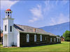
Methodist Episcopal Church South Methodist Episcopal Church South November 24, 1997 (#97001453 ) Junction of 1st St. and the Eastside Highway 46°18′57″N 114°06′48″W / 46.315833°N 114.113333°W / 46.315833; -114.113333 (Methodist Episcopal Church South ) Corvallis
68
Philip and Ella Morr House Philip and Ella Morr House June 19, 1991 (#91000760 ) 502 Buck St. 46°30′24″N 114°05′41″W / 46.506667°N 114.094722°W / 46.506667; -114.094722 (Philip and Ella Morr House ) Stevensville part of the Stevensville MRA
69
Pine Apartments Pine Apartments August 26, 1988 (#88001295 ) 804 S. 4th St. 46°14′20″N 114°09′29″W / 46.238889°N 114.158056°W / 46.238889; -114.158056 (Pine Apartments ) Hamilton part of the Hamilton MRA
70
Popham Ranch Popham Ranch January 13, 1989 (#88003141 ) 460 NE. Popham Ln. 46°20′45″N 114°05′29″W / 46.345833°N 114.091389°W / 46.345833; -114.091389 (Popham Ranch ) Corvallis
71
Ravalli County Courthouse Ravalli County Courthouse April 20, 1979 (#79001424 ) 225 Bedford St. 46°14′40″N 114°09′26″W / 46.244444°N 114.157222°W / 46.244444; -114.157222 (Ravalli County Courthouse ) Hamilton The old courthouse, now a local history museum
72
Riverside Riverside July 16, 1987 (#87001235 ) 251 Eastside Highway 46°15′57″N 114°08′20″W / 46.265833°N 114.138889°W / 46.265833; -114.138889 (Riverside ) Hamilton Once the home of Marcus Daly
73
Rocky Mountain Laboratory Historic District Rocky Mountain Laboratory Historic District September 1, 1988 (#88001274 ) 900 block of 4th St. 46°14′14″N 114°09′29″W / 46.237222°N 114.158056°W / 46.237222; -114.158056 (Rocky Mountain Laboratory Historic District ) Hamilton part of the Hamilton MRA
74
St. Mary's Church and Pharmacy St. Mary's Church and Pharmacy October 6, 1970 (#70000364 ) North Ave.August 16, 2010 , refnum 10000552): West end of 4th St. 46°30′29″N 114°05′43″W / 46.508056°N 114.095278°W / 46.508056; -114.095278 (St. Mary's Church and Pharmacy ) Stevensville
75
St. Mary Peak Lookout St. Mary Peak Lookout April 6, 2018 (#100002299 ) Saint Mary Peak , Stevensville Ranger Dist., Bitterroot NF 46°30′42″N 114°14′37″W / 46.511779°N 114.243741°W / 46.511779; -114.243741 (St. Mary Peak Lookout ) Stevensville vicinity
76
John Sharp House John Sharp House June 19, 1991 (#91000761 ) 306 College St. 46°30′33″N 114°05′22″W / 46.509167°N 114.089444°W / 46.509167; -114.089444 (John Sharp House ) Stevensville part of the Stevensville MRA
77
Stevensville Feed Mill Stevensville Feed Mill June 19, 1991 (#91000762 ) 407 Main St. 46°30′29″N 114°05′36″W / 46.508056°N 114.093333°W / 46.508056; -114.093333 (Stevensville Feed Mill ) Stevensville part of the Stevensville MRA
78
Stevensville Grade School-United Methodist Church Stevensville Grade School-United Methodist Church June 19, 1991 (#91000764 ) 216 College St. 46°30′36″N 114°05′22″W / 46.51°N 114.089444°W / 46.51; -114.089444 (Stevensville Grade School-United Methodist Church ) Stevensville part of the Stevensville MRA
79
Stevensville Mercantile Company Oil Storage Building Stevensville Mercantile Company Oil Storage Building June 19, 1991 (#91000763 ) 300 Mission St. 46°30′36″N 114°05′43″W / 46.51°N 114.095278°W / 46.51; -114.095278 (Stevensville Mercantile Company Oil Storage Building ) Stevensville part of the Stevensville MRA; demolished
80
John Stout House John Stout House August 26, 1988 (#88001290 ) 1000 S. 1st 46°14′13″N 114°09′11″W / 46.236944°N 114.153056°W / 46.236944; -114.153056 (John Stout House ) Hamilton part of the Hamilton MRA
81
Summers-Quast Farmstead Summers-Quast Farmstead December 30, 1997 (#97001590 ) 1288 Eastside Highway 46°19′39″N 114°06′45″W / 46.3275°N 114.1125°W / 46.3275; -114.1125 (Summers-Quast Farmstead ) Corvallis
82
Thornton Hospital Thornton Hospital June 19, 1991 (#91000765 ) 107 E. 3rd St. 46°30′35″N 114°06′17″W / 46.509722°N 114.104722°W / 46.509722; -114.104722 (Thornton Hospital ) Stevensville part of the Stevensville MRA
83
Erick Trosdahl House Erick Trosdahl House August 26, 1988 (#88001275 ) 206 S. 7th St. 46°14′43″N 114°09′46″W / 46.245278°N 114.162778°W / 46.245278; -114.162778 (Erick Trosdahl House ) Hamilton part of the Hamilton MRA
84
University Heights Historic District Upload image August 14, 2012 (#12000501 ) 469 Bunkhouse Creek Rd. 46°01′50″N 114°13′05″W / 46.030685°N 114.217991°W / 46.030685; -114.217991 (University Heights Historic District ) Darby vicinity
85
VFW Club VFW Club August 26, 1988 (#88001287 ) 930 Adirondac 46°15′18″N 114°10′16″W / 46.255°N 114.171111°W / 46.255; -114.171111 (VFW Club ) Hamilton part of the Hamilton MRA
86
Frank Wallin House Frank Wallin House August 26, 1988 (#88001293 ) 608 N. 7th St. 46°15′08″N 114°09′51″W / 46.252222°N 114.164167°W / 46.252222; -114.164167 (Frank Wallin House ) Hamilton part of the Hamilton MRA
87
Other C. Wamsley House Other C. Wamsley House August 26, 1988 (#88001285 ) 200 N. 5th St. 46°14′54″N 114°09′37″W / 46.248333°N 114.160278°W / 46.248333; -114.160278 (Other C. Wamsley House ) Hamilton part of the Hamilton MRA
88
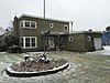
West Fork Ranger Station West Fork Ranger Station July 18, 2023 (#100009135 ) 6735 West Fork Rd. 45°48′58″N 114°15′30″W / 45.8160°N 114.2583°W / 45.8160; -114.2583 (West Fork Ranger Station ) Darby vicinity
89
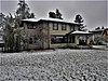
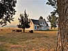
Whaley Homestead Whaley Homestead March 26, 1992 (#91000442 ) Wildfowl Rd. west of the East Side Highway in the Lee Metcalf National Wildlife Refuge 46°33′03″N 114°04′36″W / 46.550833°N 114.076667°W / 46.550833; -114.076667 (Whaley Homestead ) Stevensville
90
Williams House Williams House June 19, 1991 (#91000766 ) 500 5th St. 46°30′23″N 114°05′11″W / 46.506389°N 114.086389°W / 46.506389; -114.086389 (Williams House ) Stevensville part of the Stevensville MRA
91
John and Ann Williams House John and Ann Williams House June 19, 1991 (#91000735 ) 205 Church St. 46°30′37″N 114°05′29″W / 46.510278°N 114.091389°W / 46.510278; -114.091389 (John and Ann Williams House ) Stevensville part of the Stevensville MRA
92
Benjamin Young House Benjamin Young House June 19, 1991 (#91000741 ) 523 Main St. 46°30′18″N 114°05′33″W / 46.505°N 114.0925°W / 46.505; -114.0925 (Benjamin Young House ) Stevensville part of the Stevensville MRA