253:
107:
325:. Its name was first proposed by D.B. Dowling in 1909 (Coal Fields South of Grand Trunk Pacific Railway, in the foothills of the Rocky Mountain, Alberta Page 140 paragraph 4 " to this it is proposed to give the name Nikanassin, from the Cree word meaning outer range" Also it is noted on the map by D.B. Dowling.(Geological Survey of Canada. Incorrect info follows: It was named by B.R. MacKay in 1929 for the
675:
575:
Glass, D.J. (editor) 1997. Lexicon of
Canadian Stratigraphy, vol. 4, Western Canada including eastern British Columbia, Alberta, Saskatchewan and southern Manitoba. Canadian Society of Petroleum Geologists, Calgary, 1423 p. on CD-ROM.
373:
The
Nikanassin Formation grades from marine sediments at the base to coastal and continental at the top. The sediments were derived from newly uplifted mountains to the west and deposited along the western margin of the
670:
680:
489:
Poulton, T.P., Tittemore, J. and Dolby, G. 1990. Jurassic strata of northwestern (and west-central) Alberta and northeastern
British Columbia. Bulletin of Canadian Petroleum Geology 38A: 159-175.
645:
685:
441:
A major period of regional erosion occurred after the deposition of the
Nikanassin, removing some of the uppermost Nikanassin strata prior to the deposition of the overlying
1192:
638:
530:
196:
506:"The Geological Atlas of the Western Canada Sedimentary Basin, Chapter 18: Jurassic and Lowermost Cretaceous strata of the Western Canada Sedimentary Basin"
1222:
662:
631:
418:. From there it thins toward the east and north. It extends into the southernmost part of northeastern British Columbia, where it transitions into the
398:. The sandstones are dark grey, hard, mostly quartzose, and fine- to medium-grained. In the foothills the upper beds are nonmarine and include thin
1207:
1177:
505:
438:
north of northeastern
British Columbia. It conformably overlies and interfingers with the "Passage Beds" at the top of the Fernie Formation.
1202:
1197:
603:
314:
240:
581:
654:
742:
732:
504:
Mossop, G.D. and
Shetsen, I., (compilers), Canadian Society of Petroleum Geologists and Alberta Geological Survey (1994).
189:
1187:
477:
1212:
1182:
1217:
1067:
737:
411:
346:
1094:
1089:
1079:
375:
342:
1045:
1030:
912:
846:
442:
1052:
998:
944:
841:
836:
1114:
1099:
1062:
949:
902:
789:
607:
509:
362:
120:
1139:
1134:
1129:
1119:
1057:
907:
831:
794:
473:
1040:
1008:
826:
814:
809:
774:
769:
358:
1013:
993:
976:
929:
917:
885:
868:
863:
858:
804:
799:
577:
524:
446:
130:
1104:
1025:
1003:
988:
971:
966:
954:
934:
890:
819:
715:
701:
379:
330:
326:
322:
306:
273:
140:
1156:
1149:
1144:
1074:
1035:
983:
706:
106:
1124:
1084:
1020:
939:
924:
895:
853:
431:
415:
354:
1171:
338:
298:
65:
24:
961:
880:
779:
747:
623:
450:
435:
419:
294:
1109:
784:
727:
302:
40:
30:
402:
beds and carbonaceous shales. There are no commercially significant coal beds.
545:
85:
50:
212:
198:
391:
310:
163:
90:
34:
753:
80:
75:
60:
55:
45:
350:
318:
95:
70:
258:
395:
167:
399:
177:
627:
414:, reaching a maximum of about 400 meters (1,300 ft) near
410:
The
Nikanassin thickens northward from the foothills near the
449:. The contact between the two formations is thus sharp and
480:, "A" Series Map 208A, Scale: 1:63360 (1 Inch to 1 Mile).
762:
694:
661:
378:, which is represented by the marine shales of the
313:) age. It is present along the western edge of the
279:
269:
264:
246:
236:
188:
183:
173:
159:
154:
146:
136:
126:
116:
18:
472:Mackay, B.R., 1929a. Mountain Park Sheet, West of
639:
8:
529:: CS1 maint: multiple names: authors list (
430:The Nikanassin is roughly equivalent to the
390:The Nikanassin consists primarily of marine
646:
632:
624:
499:
497:
495:
434:of the southern Alberta foothills and the
105:
15:
598:
596:
594:
592:
590:
1193:Geologic formations of British Columbia
571:
569:
567:
565:
563:
561:
468:
466:
462:
522:
7:
676:Frontier exploration and development
329:of the front-central ranges of the
1223:Western Canadian Sedimentary Basin
604:Lexicon of Canadian Geologic Units
14:
655:Western Canada Sedimentary Basin
315:Western Canada Sedimentary Basin
251:
241:Western Canada Sedimentary Basin
150:400 meters (1,300 ft) to 0
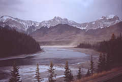
111:Nikanassin Formation near Brule
1208:Sandstone formations of Canada
1178:Geologic formations of Alberta
341:). Mackay did not designate a
1:
1203:Cretaceous British Columbia
711:Northwestern Alberta Plains
478:Geological Survey of Canada
426:Relationship to other units
394:interbedded with dark grey
1239:
406:Thickness and distribution
1198:Jurassic British Columbia
104:
23:
738:Northern Rocky Mountains
412:North Saskatchewan River
349:, although he described
724:North-central foothills
671:Oil sands and heavy oil
376:Western Interior Seaway
337:means "first range" in
608:"Nikanassin Formation"
213:53.28917°N 117.87611°W
695:Depositional regions
369:Depositional history
363:Jasper National Park
291:Nikanassin Formation
224:Nikanassin Formation
218:53.28917; -117.87611
121:Geological formation
19:Nikanassin Formation
1053:Beaverhill Lake GRP
681:Natural gas liquids
663:Hydrocarbon history
353:near the hamlet of
208: /
25:Stratigraphic range
1188:Cretaceous Alberta
903:Schooler Creek GRP
546:"Nikanassin Range"
359:Yellowhead Highway
1165:
1164:
1068:Fort Vermilion FM
832:Fort St. John GRP
721:North-east Plains
447:Cadomin Formation
321:and northeastern
287:
286:
131:Cadomin Formation
1230:
1213:Shale formations
1183:Jurassic Alberta
1095:Sulphur Point FM
1080:Watt Mountain FM
891:Poker Chip Shale
763:Northwest plains
716:Canadian Rockies
702:Southern Alberta
648:
641:
634:
625:
618:
617:
615:
614:
600:
585:
573:
556:
555:
553:
552:
541:
535:
534:
528:
520:
518:
517:
508:. Archived from
501:
490:
487:
481:
470:
380:Fernie Formation
331:Canadian Rockies
327:Nikanassin Range
323:British Columbia
307:Early Cretaceous
274:Nikanassin Range
257:
255:
254:
232:
231:
229:
228:
227:
225:
220:
219:
214:
209:
206:
205:
204:
201:
141:Fernie Formation
109:
100:
37:
16:
1238:
1237:
1233:
1232:
1231:
1229:
1228:
1227:
1218:Coal formations
1168:
1167:
1166:
1161:
1157:Canadian Shield
1046:Cooking Lake FM
1031:Fort Simpson FM
913:Charlie Lake FM
847:Spirit River FM
815:Pouce Coupe MBR
758:
707:Central Alberta
690:
657:
652:
622:
621:
612:
610:
602:
601:
588:
574:
559:
550:
548:
543:
542:
538:
521:
515:
513:
503:
502:
493:
488:
484:
471:
464:
459:
428:
408:
388:
371:
357:, north of the
252:
250:
223:
221:
217:
215:
211:
210:
207:
202:
199:
197:
195:
194:
112:
99:
98:
93:
88:
83:
78:
73:
68:
63:
58:
53:
48:
43:
29:
28:
12:
11:
5:
1236:
1234:
1226:
1225:
1220:
1215:
1210:
1205:
1200:
1195:
1190:
1185:
1180:
1170:
1169:
1163:
1162:
1160:
1159:
1154:
1153:
1152:
1147:
1145:Basal Red Beds
1142:
1137:
1132:
1127:
1122:
1117:
1112:
1107:
1102:
1097:
1092:
1087:
1082:
1072:
1071:
1070:
1065:
1060:
1050:
1049:
1048:
1043:
1038:
1033:
1028:
1018:
1017:
1016:
1014:Jean Marie MBR
1006:
1001:
999:Trout River FM
996:
991:
986:
981:
980:
979:
974:
969:
959:
958:
957:
952:
947:
945:Taylor Flat FM
937:
932:
927:
922:
921:
920:
915:
910:
900:
899:
898:
893:
888:
886:Rock Creek MBR
878:
873:
872:
871:
866:
861:
851:
850:
849:
844:
842:Peace River FM
839:
837:Shaftesbury FM
829:
824:
823:
822:
817:
812:
807:
802:
797:
792:
782:
777:
772:
766:
764:
760:
759:
757:
756:
750:
745:
740:
735:
730:
725:
722:
719:
714:South-central
712:
709:
704:
698:
696:
692:
691:
689:
688:
683:
678:
673:
667:
665:
659:
658:
653:
651:
650:
643:
636:
628:
620:
619:
586:
557:
536:
491:
482:
474:Fifth Meridian
461:
460:
458:
455:
432:Kootenay Group
427:
424:
407:
404:
387:
384:
370:
367:
285:
284:
281:
277:
276:
271:
267:
266:
262:
261:
248:
244:
243:
238:
234:
233:
192:
186:
185:
181:
180:
175:
171:
170:
161:
157:
156:
152:
151:
148:
144:
143:
138:
134:
133:
128:
124:
123:
118:
114:
113:
110:
102:
101:
94:
89:
84:
79:
74:
69:
64:
59:
54:
49:
44:
39:
38:
21:
20:
13:
10:
9:
6:
4:
3:
2:
1235:
1224:
1221:
1219:
1216:
1214:
1211:
1209:
1206:
1204:
1201:
1199:
1196:
1194:
1191:
1189:
1186:
1184:
1181:
1179:
1176:
1175:
1173:
1158:
1155:
1151:
1148:
1146:
1143:
1141:
1138:
1136:
1133:
1131:
1128:
1126:
1123:
1121:
1118:
1116:
1113:
1111:
1108:
1106:
1103:
1101:
1100:Pine Point FM
1098:
1096:
1093:
1091:
1090:Presqu’ile FM
1088:
1086:
1083:
1081:
1078:
1077:
1076:
1075:Elk Point GRP
1073:
1069:
1066:
1064:
1063:Swan Hills FM
1061:
1059:
1056:
1055:
1054:
1051:
1047:
1044:
1042:
1039:
1037:
1034:
1032:
1029:
1027:
1024:
1023:
1022:
1019:
1015:
1012:
1011:
1010:
1007:
1005:
1002:
1000:
997:
995:
992:
990:
987:
985:
982:
978:
975:
973:
970:
968:
965:
964:
963:
960:
956:
953:
951:
950:Kiskatinaw FM
948:
946:
943:
942:
941:
938:
936:
933:
931:
928:
926:
923:
919:
916:
914:
911:
909:
906:
905:
904:
901:
897:
894:
892:
889:
887:
884:
883:
882:
879:
877:
876:Nikanassin FM
874:
870:
867:
865:
862:
860:
857:
856:
855:
852:
848:
845:
843:
840:
838:
835:
834:
833:
830:
828:
825:
821:
820:Doe Creek MBR
818:
816:
813:
811:
808:
806:
803:
801:
798:
796:
793:
791:
790:Puskwaskau FM
788:
787:
786:
783:
781:
778:
776:
773:
771:
768:
767:
765:
761:
755:
751:
749:
746:
744:
743:Fort St. John
741:
739:
736:
734:
731:
729:
726:
723:
720:
717:
713:
710:
708:
705:
703:
700:
699:
697:
693:
687:
684:
682:
679:
677:
674:
672:
669:
668:
666:
664:
660:
656:
649:
644:
642:
637:
635:
630:
629:
626:
609:
605:
599:
597:
595:
593:
591:
587:
583:
582:0-920230-23-7
579:
572:
570:
568:
566:
564:
562:
558:
547:
540:
537:
532:
526:
512:on 2013-03-26
511:
507:
500:
498:
496:
492:
486:
483:
479:
475:
469:
467:
463:
456:
454:
452:
451:unconformable
448:
444:
443:conglomerates
439:
437:
433:
425:
423:
421:
417:
413:
405:
403:
401:
397:
393:
385:
383:
381:
377:
368:
366:
364:
360:
356:
352:
348:
344:
343:type locality
340:
336:
332:
328:
324:
320:
316:
312:
308:
304:
300:
299:Late Jurassic
296:
295:stratigraphic
292:
282:
278:
275:
272:
268:
263:
260:
249:
245:
242:
239:
235:
230:
193:
191:
187:
182:
179:
176:
172:
169:
165:
162:
158:
153:
149:
145:
142:
139:
135:
132:
129:
125:
122:
119:
115:
108:
103:
97:
92:
87:
82:
77:
72:
67:
62:
57:
52:
47:
42:
36:
32:
26:
22:
17:
1150:Granite Wash
1140:Ernestina FM
1135:Cold Lake FM
1130:Chinchaga FM
1120:Keg River FM
1085:Gillwood MBR
1058:Waterways FM
1021:Woodbend GRP
940:Stoddart GRP
908:Baldonnel FM
875:
854:Bullhead GRP
748:Saskatchewan
611:. Retrieved
549:. Retrieved
544:Bivuac.com.
539:
514:. Retrieved
510:the original
485:
440:
436:Minnes Group
429:
420:Minnes Group
409:
389:
372:
334:
290:
288:
283:MacKay, 1929
265:Type section
1125:Rainbow MBR
1115:Black Shale
1041:Duvernay FM
1009:Redknife FM
896:Nordegg MBR
827:Dunvegan FM
810:Kaskapau FM
795:Badheart FM
775:Scollard FM
770:Paskapoo FM
733:Fort Nelson
728:Liard River
686:Natural gas
476:, Alberta;
361:outside of
317:in western
303:Portlandian
216: /
203:117°52′34″W
190:Coordinates
31:Portlandian
1172:Categories
1026:Irteton FM
994:Wabamun FM
977:Pekisko FM
962:Rundle GRP
930:Montney FM
918:Halfway FM
881:Fernie GRP
869:Cadomin FM
864:Gething FM
859:Bluesky FM
805:Cardium FM
800:Muskiki FM
780:Wapiti GRP
613:2009-02-05
551:2009-02-05
516:2013-08-01
457:References
392:sandstones
335:Nikanassin
222: (
200:53°17′21″N
1105:Muskeg FM
1004:Kakisa FM
989:Exshaw FM
972:Shunda FM
967:Debolt FM
955:Golata FM
935:Belloy FM
785:Smoky GRP
718:foothills
386:Lithology
347:formation
311:Barremian
270:Named for
164:Sandstone
155:Lithology
147:Thickness
127:Underlies
35:Barremian
1110:Zama MBR
1036:Leduc FM
984:Banff FM
754:Manitoba
752:Western
525:cite web
351:outcrops
345:for the
297:unit of
280:Named by
184:Location
137:Overlies
925:Doig FM
445:of the
319:Alberta
247:Country
160:Primary
580:
396:shales
259:Canada
256:
237:Region
416:Brûlé
355:Brûlé
305:) to
293:is a
174:Other
168:shale
578:ISBN
531:link
400:coal
339:Cree
289:The
178:Coal
117:Type
41:PreꞒ
33:to
1174::
606:.
589:^
560:^
527:}}
523:{{
494:^
465:^
453:.
422:.
382:.
365:.
166:,
91:Pg
27::
647:e
640:t
633:v
616:.
584:.
554:.
533:)
519:.
333:(
309:(
301:(
226:)
96:N
86:K
81:J
76:T
71:P
66:C
61:D
56:S
51:O
46:Ꞓ
Text is available under the Creative Commons Attribution-ShareAlike License. Additional terms may apply.