41:
40:
199:
since 1975. Following an effort to clear the island of ordnance in 1997 and 1998, the rest of the island was transferred to the FWS for use as a wildlife refuge, primarily for migratory birds. It now forms
384:
399:
299:
409:
389:
321:
220:
269:
201:
352:
196:
211:
areas, R-4105A and R-4105B, overlaid the island due to the site's former use as a range. These restricted areas were revoked in
October 2014.
244:
348:
67:
185:, as Nomans Land Range for 53 years, 1943-1996. The airfield was abandoned by the U.S. Navy sometime between 1945 and 1954.
174:
404:
279:
159:
181:
on the southern edge of the island between
November 1942 and May 1944, and the island was used, beginning in
394:
163:
115:
49:
45:
208:
322:"Federal Register | Revocation of Restricted Areas R-4105A and R-4105B; No Man's Land Island, MA"
240:
178:
291:
283:
274:
378:
182:
364:
359:
287:
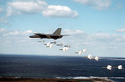
82:
69:
295:
189:
53:
241:"Abandoned & Little-Known Airfields: Southeastern Massachusetts"
385:
195:
The eastern third of the island has been managed by the
56:
practice bombs during a training mission over the island
400:
Buildings and structures in Dukes County, Massachusetts
188:
In 1952 the island was sold by the Crane family to the
158:
was a former naval bomb range for aviators, located on
263:
261:
144:
139:
129:
121:
111:
106:
98:
61:
21:
221:List of military installations in Massachusetts
410:Closed installations of the United States Navy
16:Bombing range in Massachusetts, United States
8:
349:Nomans Land Island National Wildlife Refuge
202:Nomans Land Island National Wildlife Refuge
390:Military installations closed in the 1990s
371:, Volume II by Dr. Charles E. Banks. 1911.
18:
270:"Officials want it to stay Nomans Land"
231:
245:Abandoned & Little-Known Airfields
7:
302:from the original on 17 March 2021
268:MacQuarrie, Brian (12 July 2021).
14:
369:The History of Martha's Vineyard
353:U.S. Fish & Wildlife Service
39:
197:Fish and Wildlife Service (FWS)
1:
125:Commonwealth of Massachusetts
426:
27:Part of United States Navy
83:41.2550000°N 70.8150000°W
38:
33:Chilimark, Massachusetts
31:
26:
326:www.federalregister.gov
177:was constructed by the
164:Chilmark, Massachusetts
116:Chilmark, Massachusetts
88:41.2550000; -70.8150000
50:509th Bombardment Wing
209:restricted airspace
79: /
360:Annals of Chilmark
156:Noman’s Land Range
122:Controlled by
22:Noman’s Land Range
405:Martha's Vineyard
152:
151:
417:
337:
336:
334:
332:
318:
312:
311:
309:
307:
275:The Boston Globe
265:
256:
255:
253:
251:
236:
107:Site information
94:
93:
91:
90:
89:
84:
80:
77:
76:
75:
72:
43:
34:
19:
425:
424:
420:
419:
418:
416:
415:
414:
375:
374:
345:
340:
330:
328:
320:
319:
315:
305:
303:
267:
266:
259:
249:
247:
239:Freeman, Paul.
238:
237:
233:
229:
217:
172:
132:the public
131:
87:
85:
81:
78:
73:
70:
68:
66:
65:
57:
32:
17:
12:
11:
5:
423:
421:
413:
412:
407:
402:
397:
395:Bombing ranges
392:
387:
377:
376:
373:
372:
356:
344:
343:External links
341:
339:
338:
313:
257:
230:
228:
225:
224:
223:
216:
213:
171:
168:
150:
149:
146:
142:
141:
137:
136:
133:
127:
126:
123:
119:
118:
113:
109:
108:
104:
103:
100:
96:
95:
63:
59:
58:
44:
36:
35:
29:
28:
24:
23:
15:
13:
10:
9:
6:
4:
3:
2:
422:
411:
408:
406:
403:
401:
398:
396:
393:
391:
388:
386:
383:
382:
380:
370:
366:
362:
361:
357:
354:
350:
347:
346:
342:
327:
323:
317:
314:
301:
297:
293:
289:
285:
282:. p. 1.
281:
277:
276:
271:
264:
262:
258:
246:
242:
235:
232:
226:
222:
219:
218:
214:
212:
210:
205:
203:
198:
193:
191:
186:
184:
180:
176:
169:
167:
165:
161:
157:
147:
143:
138:
134:
128:
124:
120:
117:
114:
110:
105:
101:
97:
92:
74:70°48′54.00″W
71:41°15′18.00″N
64:
60:
55:
51:
47:
42:
37:
30:
25:
20:
368:
358:
329:. Retrieved
325:
316:
304:. Retrieved
273:
248:. Retrieved
234:
206:
194:
187:
183:World War II
173:
155:
153:
140:Site history
130:Open to
365:Nomans Land
280:Nomans Land
175:An airfield
160:Nomans Land
145:In use
86: /
62:Coordinates
379:Categories
306:2 November
227:References
288:0743-1791
179:U.S. Navy
148:1944-1946
52:dropping
48:from the
367:". From
300:Archived
296:66652431
215:See also
351:at the
331:23 July
250:4 March
170:History
54:Mark 82
46:FB-111A
294:
286:
162:, in
112:Owner
102:Range
355:site
333:2016
308:2021
292:OCLC
284:ISSN
252:2012
207:Two
190:Navy
154:The
99:Type
363:, "
381::
324:.
298:.
290:.
278:.
272:.
260:^
243:.
204:.
192:.
166:.
135:No
335:.
310:.
254:.
Text is available under the Creative Commons Attribution-ShareAlike License. Additional terms may apply.