42:
49:
29:
307:
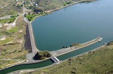
The North Dam, near the town of Grand Coulee, has a maximum height of 145 feet (44 m) and a crest length of 1,400 feet (430 m). Crest elevation of both dams is 1,580 feet (480 m), and the maximum water level in Banks Lake is elevation 1,570 feet (480 m). Both North and Dry Falls
443:
Draft
Environmental Statement, Columbia Basin Project, Washington; Columbia Basin Project, Ephrata, Washington; Department of the Interior, (INT DES-75-3), Bureau of Reclamation, Department of the Interior; Washington, D.C.;
465:
393:
485:
470:
418:
347:
41:
397:
490:
460:
143:
92:
475:
422:
351:
480:
269:
265:
76:
273:
80:
321:
289:
309:
296:
is the entrance to the feeder canal of the project. The canal serves to either deliver water to the
276:, United States. Construction of the dam began in 1946 and it was completed in 1951. Along with
297:
301:
261:
230:
454:
277:
285:
168:
280:
about 22 mi (35 km) to the southeast, North Dam creates the reservoir
378:. Washington D.C.: United States Government Printing Office. 1964. p. 59.
281:
207:
107:
94:
293:
28:
155:
288:
riverbed. The lake serves as the equalizer reservoir of the
312:
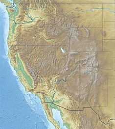
for protection against wave action due to high winds.
466:
Buildings and structures in Grant County, Washington
247:
239:
229:
221:
213:
203:
198:
190:
182:
174:
164:
154:
149:
139:
131:
123:
86:
72:
64:
21:
392:United States Bureau of Reclamation (2012-05-17).
346:United States Bureau of Reclamation (2012-06-21).
8:
421:. U.S. Bureau of Reclamation. Archived from
370:
368:
300:or return water to Banks Lake from the same
387:
385:
27:
18:
486:1951 establishments in Washington (state)
394:"Dry Falls Dam: Hydraulics and Hydrology"
341:
339:
337:
298:pump-generating plant at Grand Coulee Dam
56:Location of North Dam in the western U.S.
471:United States Bureau of Reclamation dams
376:The Story of the Columbia Basin Project
333:
217:1,275,000 acre⋅ft (1.573 km)
7:
225:715,000 acre⋅ft (0.882 km)
235:278.3 sq mi (721 km)
144:United States Bureau of Reclamation
308:dams have 10 feet (3.0 m) of
14:
48:
47:
40:
16:Dam in Grant County, Washington
1:
292:. Near the North Dam's left
191:Elevation at crest
507:
491:Dams in the Columbia Basin
461:Dams in Washington (state)
251:1,570 ft (480 m)
243:27,000 acres (109 km)
194:1,580 ft (480 m)
186:1,450 ft (442 m)
108:47.9408417°N 119.0174056°W
35:
26:
113:47.9408417; -119.0174056
178:145 ft (44 m)
124:Construction began
476:Dams completed in 1951
419:"North Dam - Overview"
322:Columbia Basin Project
290:Columbia Basin Project
160:Embankment, earth-fill
248:Normal elevation
156:Type of dam
348:"North Dam: General"
222:Active capacity
425:on 5 September 2015
284:within the ancient
231:Catchment area
214:Total capacity
104: /
481:Earth-filled dams
264:near the town of
260:is an earth-fill
255:
254:
240:Surface area
150:Dam and spillways
132:Opening date
498:
445:
441:
435:
434:
432:
430:
415:
409:
408:
406:
405:
396:. Archived from
389:
380:
379:
372:
363:
362:
360:
359:
350:. Archived from
343:
119:
118:
116:
115:
114:
109:
105:
102:
101:
100:
97:
51:
50:
44:
31:
19:
506:
505:
501:
500:
499:
497:
496:
495:
451:
450:
449:
448:
442:
438:
428:
426:
417:
416:
412:
403:
401:
391:
390:
383:
374:
373:
366:
357:
355:
345:
344:
335:
330:
318:
112:
110:
106:
103:
98:
95:
93:
91:
90:
60:
59:
58:
57:
54:
53:
52:
17:
12:
11:
5:
504:
502:
494:
493:
488:
483:
478:
473:
468:
463:
453:
452:
447:
446:
436:
410:
381:
364:
332:
331:
329:
326:
325:
324:
317:
316:External links
314:
302:pumped-storage
262:embankment dam
253:
252:
249:
245:
244:
241:
237:
236:
233:
227:
226:
223:
219:
218:
215:
211:
210:
205:
201:
200:
196:
195:
192:
188:
187:
184:
180:
179:
176:
172:
171:
166:
162:
161:
158:
152:
151:
147:
146:
141:
137:
136:
133:
129:
128:
125:
121:
120:
88:
84:
83:
74:
70:
69:
66:
62:
61:
55:
46:
45:
39:
38:
37:
36:
33:
32:
24:
23:
15:
13:
10:
9:
6:
4:
3:
2:
503:
492:
489:
487:
484:
482:
479:
477:
474:
472:
469:
467:
464:
462:
459:
458:
456:
440:
437:
424:
420:
414:
411:
400:on 2015-06-16
399:
395:
388:
386:
382:
377:
371:
369:
365:
354:on 2015-06-16
353:
349:
342:
340:
338:
334:
327:
323:
320:
319:
315:
313:
311:
305:
303:
299:
295:
291:
287:
283:
279:
278:Dry Falls Dam
275:
271:
267:
263:
259:
250:
246:
242:
238:
234:
232:
228:
224:
220:
216:
212:
209:
206:
202:
197:
193:
189:
185:
181:
177:
173:
170:
167:
163:
159:
157:
153:
148:
145:
142:
138:
134:
130:
126:
122:
117:
96:47°56′27.03″N
89:
85:
82:
78:
75:
71:
68:United States
67:
63:
43:
34:
30:
25:
20:
439:
427:. Retrieved
423:the original
413:
402:. Retrieved
398:the original
375:
356:. Retrieved
352:the original
306:
286:Grand Coulee
270:Grant County
266:Grand Coulee
257:
256:
169:Grand Coulee
99:119°1′2.66″W
77:Grant County
140:Operator(s)
111: /
87:Coordinates
455:Categories
429:24 January
404:2015-01-23
358:2015-01-23
328:References
282:Banks Lake
274:Washington
208:Banks Lake
81:Washington
310:freeboard
258:North Dam
199:Reservoir
22:North Dam
294:abutment
165:Impounds
73:Location
304:plant.
204:Creates
65:Country
183:Length
175:Height
444:1975
431:2015
135:1951
127:1946
268:in
457::
384:^
367:^
336:^
272:,
79:,
433:.
407:.
361:.
Text is available under the Creative Commons Attribution-ShareAlike License. Additional terms may apply.