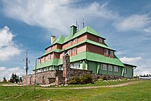
461:
303:
140:
316:
29:
420:
The entire region has maintained its original natural character over the centuries and so beech primeval forests, protected landscape areas or nature parks and reserves are interwoven with trails, right next to chateaux and town parks and groomed rural gardens. The gentle rolling hills are interlaced
467:
460:
565:
185:
71:
446:
337:
560:
388:
407:
294:
The mountains are mainly composed of crystalline rocks, consistent with the makeup of the northern rim of the highlands of
Bohemia.
360:
434:
367:
341:
374:
178:
64:
326:
162:
356:
170:
345:
330:
445:
Until 1945 the Orlické Mountains were predominantly German populated, the population was expropriated and
492:[Administration of PLA Orlické hory] (in Czech). Nature Conservation Agency of the Czech Republic
283:
47:
381:
302:
511:
555:
166:
271:
247:
239:
275:
267:
259:
231:
139:
549:
429:
Most of the Orlické Mountains are part of the Orlické hory
Protected Landscape Area (
421:
with hiking trails, a dense network of cycle trails and routes leading along rivers.
315:
28:
200:
187:
86:
73:
537:– official tourist portal of the region operated by local destination agency
489:
263:
144:
Orlické Mountains in the geomorphological system of the Czech
Republic
279:
54:
540:
301:
534:
282:
for 40 km (25 mi). The highest point in the range is
449:. Subsequently, new citizens moved here from the Czech lands.
309:
220:
Bystrzyckie
Mountains, Table Mountains and Śnieżnik Mountains
216:
177:
158:
150:
131:
123:
115:
107:
102:
63:
53:
43:
38:
21:
470:Panorama of the Orlické Mountains from the south
8:
344:. Unsourced material may be challenged and
18:
408:Learn how and when to remove this message
481:
566:Mountain ranges of the Czech Republic
541:Orlické hory Protected Landscape Area
7:
342:adding citations to reliable sources
16:Mountain range in the Czech Republic
14:
286:at 1,116 m (3,661 ft).
127:341 km (132 sq mi)
459:
314:
138:
27:
437:of 204 km established in 1969.
262:located mainly in northeastern
512:"Geschichte des Adlergebirges"
274:. They follow the border with
1:
270:. It is a mesoregion of the
59:1,116 m (3,661 ft)
582:
490:"Správa CHKO Orlické hory"
171:Lower Silesian Voivodeship
561:Mountain ranges of Poland
154:Czech Republic and Poland
136:
26:
306:Shelter Masarykova Chata
119:8 km (5.0 mi)
111:50 km (31 mi)
307:
251:
243:
235:
33:View from Velká Deštná
305:
163:Hradec Králové Region
87:50.30500°N 16.39917°E
338:improve this section
357:"Orlické Mountains"
197: /
83: /
308:
92:50.30500; 16.39917
39:Highest point
535:EagleMountains.cz
431:CHKO Orlické hory
418:
417:
410:
392:
228:Orlické Mountains
224:
223:
201:50.167°N 16.550°E
179:Range coordinates
22:Orlické Mountains
573:
522:
521:
519:
518:
508:
502:
501:
499:
497:
486:
463:
413:
406:
402:
399:
393:
391:
350:
318:
310:
212:
211:
209:
208:
207:
202:
198:
195:
194:
193:
190:
167:Pardubice Region
142:
98:
97:
95:
94:
93:
88:
84:
81:
80:
79:
76:
31:
19:
581:
580:
576:
575:
574:
572:
571:
570:
546:
545:
531:
526:
525:
516:
514:
510:
509:
505:
495:
493:
488:
487:
483:
478:
473:
472:
471:
469:
464:
455:
443:
427:
414:
403:
397:
394:
351:
349:
335:
319:
300:
292:
272:Central Sudetes
256:Eagle Mountains
205:
203:
199:
196:
191:
188:
186:
184:
183:
146:
145:
91:
89:
85:
82:
77:
74:
72:
70:
69:
34:
17:
12:
11:
5:
579:
577:
569:
568:
563:
558:
548:
547:
544:
543:
538:
530:
529:External links
527:
524:
523:
503:
480:
479:
477:
474:
466:
465:
458:
457:
456:
454:
451:
442:
439:
435:landscape park
426:
423:
416:
415:
322:
320:
313:
299:
296:
291:
288:
268:Czech Republic
260:mountain range
222:
221:
218:
214:
213:
206:50.167; 16.550
181:
175:
174:
160:
156:
155:
152:
148:
147:
143:
137:
134:
133:
129:
128:
125:
121:
120:
117:
113:
112:
109:
105:
104:
100:
99:
67:
61:
60:
57:
51:
50:
45:
41:
40:
36:
35:
32:
24:
23:
15:
13:
10:
9:
6:
4:
3:
2:
578:
567:
564:
562:
559:
557:
554:
553:
551:
542:
539:
536:
533:
532:
528:
513:
507:
504:
491:
485:
482:
475:
468:
462:
452:
450:
448:
440:
438:
436:
432:
424:
422:
412:
409:
401:
398:November 2022
390:
387:
383:
380:
376:
373:
369:
366:
362:
359: –
358:
354:
353:Find sources:
347:
343:
339:
333:
332:
328:
323:This section
321:
317:
312:
311:
304:
297:
295:
289:
287:
285:
281:
277:
273:
269:
265:
261:
257:
253:
249:
245:
244:Góry Orlickie
241:
237:
233:
229:
219:
215:
210:
182:
180:
176:
172:
168:
164:
161:
157:
153:
149:
141:
135:
130:
126:
122:
118:
114:
110:
106:
101:
96:
68:
66:
62:
58:
56:
52:
49:
46:
42:
37:
30:
25:
20:
515:. Retrieved
506:
496:13 September
494:. Retrieved
484:
444:
430:
428:
419:
404:
395:
385:
378:
371:
364:
352:
336:Please help
324:
293:
284:Velká Deštná
276:Kłodzko Land
255:
252:Adlergebirge
236:Orlické hory
227:
225:
48:Velká Deštná
204: /
90: /
65:Coordinates
550:Categories
517:2021-09-25
476:References
425:Protection
368:newspapers
217:Borders on
103:Dimensions
78:16°23′57″E
75:50°18′18″N
325:does not
169:(CZ) and
151:Countries
132:Geography
55:Elevation
447:expelled
556:Sudetes
453:Gallery
441:History
382:scholar
346:removed
331:sources
298:Tourism
290:Geology
266:in the
264:Bohemia
192:16°33′E
189:50°10′N
159:Regions
384:
377:
370:
363:
355:
280:Poland
258:are a
248:German
240:Polish
165:(CZ),
108:Length
433:), a
389:JSTOR
375:books
254:) or
232:Czech
116:Width
498:2019
361:news
329:any
327:cite
226:The
173:(PL)
124:Area
44:Peak
340:by
278:in
552::
250::
246:,
242::
238:,
234::
520:.
500:.
411:)
405:(
400:)
396:(
386:·
379:·
372:·
365:·
348:.
334:.
230:(
Text is available under the Creative Commons Attribution-ShareAlike License. Additional terms may apply.


