76:
48:
83:
55:
398:
410:
31:
443:
529:
429:
316:
built in two tiers. The lower tier (base) is wide, and with a total length of about 128 meters was found to be the largest in the prefecture. The second tier is about 86 meters long with a height of about 10 meters. The two-tiered mound is set on a base of similar shape, and is surrounded by a moat
374:
of the late Kofun period, from around the latter half of the 6th century. Recovered artifacts, including small objects of gold and copper found in the burial chamber, are on display at the
Shimotsuke Fudoki-ga-oka Museum at site, which is located approximately eight minutes by car from
75:
351:
with a rectangular opening for a door, whereas the ceiling stone (and remaining stones in the walls and remaining ceiling of the burial chamber) are of monolithic
397:
409:
456:
140:
333:, the front part of the rectangular portion of the tumulus was destroyed, and the entrance stone and one of the ceiling stones were removed by the
566:
47:
506:
329:
is a horizontal hole type stone chamber with dimensions of 2.4 meters long x 1.7 meters wide x 2.0 meters high; however, during the
286:
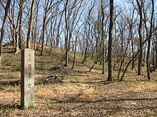
The Azuma Kofun is located on a narrow plateau between the Ogawa and Sugata rivers, which run north and south through the northern
581:
591:
355:. Red pigment was applied to the walls of the burial chamber, which was backfilled for preservation after the 2010 excavation.
586:
255:
480:
576:
291:
383:
533:
301:
296:
571:
275:
263:
220:
114:
502:
259:
110:
476:
380:
267:
128:
434:
326:
287:
560:
251:
106:
548:
448:
376:
244:
198:
30:
344:
340:
322:
424:
330:
155:
142:
335:
528:
540:
360:
352:
366:
318:
370:
have been recovered. The tumulus is a representative example of a
317:
with a width of about 20 meters and a depth of about three meters.
271:
247:
175:
118:
348:
347:, where they can still be seen. The entrance stone was of cut
403:
Entrance monolith to Azuma Kofun now relocated to Mibu Castle
415:
Ceiling monolith to Azuma Kofun now relocated to Mibu Castle
294:
from 2007 to 2010, it was determined that the tumulus is a
325:were confirmed from the soil filling the moat. The
209:
204:
194:
186:
181:
171:
134:
124:
102:
364:stones. Fragments of cylindrical and house-shaped
343:for use as ornamental stones in the gardens of
309:
236:
499:(国指定史跡事典) National Historic Site Encyclopedia
8:
16:
358:The surface of the tumulus is covered with
29:
15:
492:
490:
457:List of Historic Sites of Japan (Tochigi)
468:
393:
497:Isomura, Yukio; Sakai, Hideya (2012).
321:deposits from the 1108 AD eruption of
479:[Azuma kofun] (in Japanese).
250:located on the border of the town of
7:
82:
54:
14:
527:
441:
427:
408:
396:
81:
74:
53:
46:
221:National Historic Site of Japan
274:. It received protection as a
65:Show map of Tochigi Prefecture
1:
567:History of Tochigi Prefecture
549:Mibu Department of Education
541:Tochigi Tourist Information
481:Agency for Cultural Affairs
608:
156:36.4042111°N 139.8114250°E
310:
292:archaeological excavation
237:
217:
40:
28:
21:
582:Historic Sites of Japan
161:36.4042111; 139.8114250
276:National Historic Site
536:at Wikimedia Commons
384:Tōbu Utsunomiya Line
290:. As a result of an
587:Shimotsuke Province
256:Shimotsuga District
190:late 6th century AD
152: /
90:Azuma Kofun (Japan)
18:
264:Tochigi Prefecture
258:, and the city of
210:Public access
115:Tochigi Prefecture
532:Media related to
228:
227:
93:Show map of Japan
599:
577:Tochigi, Tochigi
553:
545:
531:
516:
515:
512:
494:
485:
484:
473:
451:
446:
445:
444:
437:
432:
431:
430:
412:
400:
315:
313:
312:
305:
266:in the northern
242:
240:
239:
167:
166:
164:
163:
162:
157:
153:
150:
149:
148:
145:
94:
85:
84:
78:
66:
57:
56:
50:
33:
19:
607:
606:
602:
601:
600:
598:
597:
596:
557:
556:
551:
543:
525:
520:
519:
513:
509:
496:
495:
488:
475:
474:
470:
465:
447:
442:
440:
433:
428:
426:
423:
416:
413:
404:
401:
392:
327:burial facility
307:
299:
284:
234:
224:
223:
160:
158:
154:
151:
146:
143:
141:
139:
138:
98:
97:
96:
95:
92:
91:
88:
87:
86:
69:
68:
67:
64:
63:
60:
59:
58:
36:
24:
12:
11:
5:
605:
603:
595:
594:
592:Zenpō-kōhō-fun
589:
584:
579:
574:
569:
559:
558:
555:
554:
546:
524:
523:External links
521:
518:
517:
508:978-4311750403
507:
486:
467:
466:
464:
461:
460:
459:
453:
452:
438:
435:History portal
422:
419:
418:
417:
414:
407:
405:
402:
395:
391:
388:
297:zenpō-kōhō-fun
283:
280:
226:
225:
219:
218:
215:
214:
211:
207:
206:
202:
201:
196:
192:
191:
188:
184:
183:
179:
178:
173:
169:
168:
147:139°48′41.13″E
136:
132:
131:
126:
122:
121:
104:
100:
99:
89:
80:
79:
73:
72:
71:
70:
61:
52:
51:
45:
44:
43:
42:
41:
38:
37:
34:
26:
25:
22:
13:
10:
9:
6:
4:
3:
2:
604:
593:
590:
588:
585:
583:
580:
578:
575:
573:
572:Mibu, Tochigi
570:
568:
565:
564:
562:
552:(in Japanese)
550:
547:
544:(in Japanese)
542:
539:
538:
537:
535:
530:
522:
514:(in Japanese)
510:
504:
500:
493:
491:
487:
482:
478:
472:
469:
462:
458:
455:
454:
450:
439:
436:
425:
420:
411:
406:
399:
394:
389:
387:
385:
382:
378:
373:
369:
368:
363:
362:
356:
354:
350:
346:
342:
338:
337:
332:
328:
324:
320:
306:
303:
298:
293:
289:
281:
279:
277:
273:
269:
265:
261:
257:
253:
249:
246:
233:
222:
216:
212:
208:
203:
200:
197:
193:
189:
185:
180:
177:
174:
170:
165:
144:36°24′15.16″N
137:
133:
130:
127:
123:
120:
116:
112:
108:
105:
101:
77:
49:
39:
32:
27:
20:
526:
498:
471:
449:Japan portal
381:Tōbu Railway
377:Mibu Station
371:
365:
359:
357:
334:
295:
285:
268:Kantō region
248:burial mound
245:Kofun period
231:
229:
199:Kofun period
129:Kantō region
534:Azuma Kofun
345:Mibu Castle
341:Mibu Domain
323:Mount Asama
300: [
288:Kantō Plain
232:Azuma Kofun
159: /
135:Coordinates
62:Azuma Kofun
35:Azuma Kofun
17:Azuma Kofun
561:Categories
463:References
331:Edo period
205:Site notes
278:in 1970.
421:See also
361:fukiishi
282:Overview
103:Location
501:. 学生社.
390:Gallery
379:on the
353:diorite
260:Tochigi
195:Periods
187:Founded
182:History
111:Tochigi
505:
477:"吾妻古墳"
367:haniwa
336:daimyō
319:Pumice
125:Region
372:kofun
311:前方後方墳
304:]
272:Japan
243:is a
176:kofun
119:Japan
503:ISBN
349:tuff
252:Mibu
238:吾妻古墳
230:The
172:Type
107:Mibu
23:吾妻古墳
339:of
270:of
262:in
213:Yes
563::
489:^
386:.
302:ja
254:,
117:,
113:,
109:/
511:.
483:.
314:)
308:(
241:)
235:(
Text is available under the Creative Commons Attribution-ShareAlike License. Additional terms may apply.