414:
522:
502:
550:
462:
54:
398:
490:
386:
474:
426:
106:
began eroding it away to become the steep cliffs we see today. Some volcanic rocks can be found on the beach below – some fragments ejected from deep in the earth, or blocks of tuff ring that were once perched on top of the cliff. Rangitoto Island is directly to the north, however
Rangitoto is a recent eruption (600 to 550 years ago) and was not always there to shelter the cliffs from powerful wave action. There is an old concrete water tower built on the
450:
438:
538:
198:
is unclear within a wide range. The cliff retreat with raising sealevels of
Achilles Point has meant, as already mentioned, that the tuff deposits 30 m (98 ft) up the cliffs, as they erode, fall onto the sea rock platform (see photos below). This has resulted in the discovery that a distinctive lithic clast in the tuff that contained shell fragments was strong evidence that the erupted magma traversed the eastern border of the
574:
19:
98:
562:
119:
521:
105:
The seaward side of the tuff crater is falling away down the coastal cliffs to 'Gentleman's Bay' far below. The tuff ring is made from ash and ejected material. The cliffs were there before the volcano erupted so the volcanic rock draped over the clay hill that once existed before sea levels rose and
22:
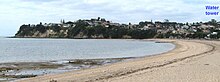
Looking east from St
Heliers Bay towards the headland which juts out towards Rangitoto. Ladies Bay, a small sandy beach just 150 meters long, is just out of view around the 'Te Wharau' point. Achilles Point, is at the eastern end of Ladies Bay. A volcanic crater extends inland from the water tower in
197:
up to 300 m (980 ft) in maximum diameter, surrounded except to the north-east by tuff deposits that extend about 500 m (1,600 ft) to the east and south. The presence of overlying
Rotoehu tephra on a drill ore means the volcano last erupted more than 45,000 years ago, but the age
501:
126:
Going east, past Ladies Bay and
Gentleman's Bay, we round the West Tamaki Head into the Tamaki Estuary. It is here we find an excellent example of the grey coloured 'Parnell Grit' accessible from Karaka Bay. 'Parnell Grit', is a brittle sedimentary rock containing fragments of
461:
178:
is made) percolating through the layers. Calcium carbonate is an important component of concrete and fills in the pore spaces between grains of sediment thereby cementing the grains together and making them more durable against
71:
is a secluded beach, below steep cliffs, on the headland west of the lookout over
Achilles point. Both Ladies Bay and further to the east, the more secluded Gentleman's Bay beach are unofficially places where
549:
413:
637:
531:
and are all on the same horizontal layer. Sometimes they might snap off. More often, the softer stone erodes away completely, leaving them resting on the surface a few meters lower.
38:, New Zealand. The name 'Te Pane o Horoiwi' can also sometimes refer to the whole headland between St Heliers and Tamaki River estuary. Achilles Point is named after a ship called
367:
Point to Point walkway. The full point to point walk is approximately 7.5km long, starting at the popular St
Heliers Bay and finishing at Point England. Allow three to four hours.
94:
Head and the eastern end of St
Heliers Bay beach. It was filled in during the 1950s to form a public sports field. Before that it formed a seasonal shallow lake or swamp.
473:
489:
46:
in 1939. The headland, from the point round to the Tamaki heads, was previously known as Te Pane o
Horoiwi, named after Horoiwi who arrived in New Zealand on the
356:
76:
can often be found enjoying the sun and sand however the fine for indecent exposure is $ 200. The secluded bays are also popular with the male gay community.
366:
630:
43:
23:
the south (right of picture) to the cliff edge in the north (left of picture) with volcanic rock falling down to the beach below just east of Ladies Bay.
917:
805:
573:
927:
623:
437:
586:
425:
397:
142:
At low tide there is an interesting walk from Ladies Bay along the base of the cliffs to St Helier's Bay. The rocky shoreline overlooks the
449:
295:
537:
333:
385:
467:
1859 map showing the volcanoes and lava flows. Glover Park volcano is to the upper right on the shores of the
Waitematā Harbour.
886:
646:
912:
891:
90:
as Whakahumu or geologically as the 'St Heliers explosion crater'. It is found in the center of the headland between West
158:
Age (15–25 million years ago). Generally, around Auckland these soft Miocene sediments are alternating Waitemata series
202:
259:"Excavation of buried Dun Mountain–Maitai terrane ophiolite by volcanoes of the Auckland Volcanic field, New Zealand"
754:
194:
688:
187:
841:
223:
683:
678:
668:
228:
922:
854:
744:
713:
53:
346:
815:
790:
780:
143:
871:
91:
57:
View from the lookout, looking east over Gentleman's Bay towards Tamaki point, the entrance to the
39:
361:
170:
that can be easily seen, are formed by the action of ground water with dissolved minerals (mainly
615:
34:) is a rocky point on the headland at the eastern end of the small sandy beach named Ladies Bay,
759:
846:
820:
785:
329:
171:
87:
881:
836:
749:
270:
151:
357:
Point to point walkway ARC – St Heliers to Churchill park through the crater at Glover Park
795:
561:
83:
86:
which erupted more than 45,000 years ago. The volcanic tuff ring crater is also known in
166:
with more massive beds of sandstone sometimes with minor occurrences of limestone. The
147:
906:
876:
800:
764:
708:
18:
810:
315:
62:
58:
698:
351:
275:
258:
718:
654:
528:
508:
167:
739:
693:
199:
601:
588:
122:
Looking north from Karaka Bay towards Tamaki Point (1 km from Achilles Point)
673:
512:
404:
175:
159:
107:
101:
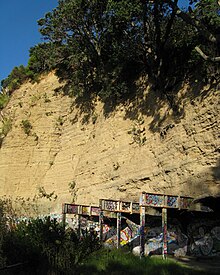
High above Gentleman's Bay, an abandoned building site with crumbling cliffs
479:
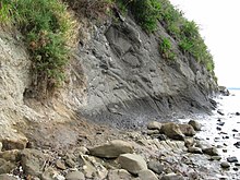
The rocks between the point and St Heliers Bay. Layers of sedimentary rock
97:
511:
are scattered and looking like fossilised logs, long after the supporting
118:
650:
163:
132:
35:
555:
Achilles Point from the viewing platform - looks like the bow of a ship.
703:
480:
180:
155:
73:
495:
The rocks between the point and St Heliers Bay. White siltstone layer.
191:
136:
128:
47:
117:
96:
52:
17:
579:
Glover Park crater with housing and water tower on the tuff ring
110:
formed around the edge of the crater opposite the seaward side.
619:
291:
Rangitoto: Odd one out. The story of Auckland's largest volcano
328:. Hayward, B.W.; Auckland University Press, 2019, 335 pp.
378:
Geological features between Ladies Bay and St Heliers Bay
443:
Cross-section of concretion snapped off at cliff wall.
507:
The rocks between the point and St Heliers Bay. The
257:
Spörli, K. B.; Black, P. M.; Lindsay, J. M. (2015).
864:
829:
773:
727:
661:
431:Discoloration of crumbling white siltstone layer.
347:Archaeology and History of St Heliers, Auckland.
296:"DEVORA Fact Sheet 3 - Rangitoto: Odd One Out"
631:
263:New Zealand Journal of Geology and Geophysics
8:
252:
250:
248:
246:
455:Concretions all line up in the cliff wall.
638:
624:
616:
44:German pocket battleship Admiral Graf Spee
543:Close up of sandstone and mudstone layers
274:
381:
214:
224:"'Dirty blokes' ruining bare-all bay"
222:MacIntyre, Jenny (10 February 2008).
7:
326:Volcanoes of Auckland: A Field Guide
515:has been eroded away by the waves.
186:Glover Park volcano formed from a
14:
918:Headlands of the Auckland Region
572:
560:
548:
536:
520:
500:
488:
472:
460:
448:
436:
424:
412:
396:
384:
855:Auckland City Council (defunct)
1:
527:The projections are known as
391:Sandstone and mudstone layers
316:Geological Map of New Zealand
276:10.1080/00288306.2015.1035285
61:estuary, then on the horizon
806:St Michael's Catholic Church
765:Takaparawhau / Bastion Point
203:Dun Mountain-Maitai Terrane
195:monogenetic volcanic crater
944:
774:Facilities and attractions
362:Explanation of concretions
602:36.843390°S 174.863800°E
188:phreatomagmatic eruption
146:which itself occupies a
928:Ōrākei Local Board Area
755:Ōhinerau / Mount Hobson
647:Ōrākei Local Board Area
352:Geology of the headland
293:. Devora Fact Sheet 03.
607:-36.843390; 174.863800
419:White rock broken away
229:The New Zealand Herald
123:
102:
65:
24:
913:Geography of Auckland
121:
100:
56:
30:(Te Pane o Horoiwi –
21:
816:Te Ara ki Uta ki Tai
791:Madills Farm Reserve
781:Ellerslie Racecourse
887:Ngāti Whātua Ōrākei
872:Eastern Suburbs AFC
728:Geographic features
598: /
42:which defeated the
40:HMNZS Achilles (70)
32:The head of Horoiwi
842:Ōrākei Local Board
403:Close up of white
124:
103:
66:
25:
900:
899:
892:St John's College
821:Waiatarua Reserve
786:Kepa Bush Reserve
172:calcium carbonate
144:Waitemata Harbour
935:
882:Ellerslie Eagles
837:Auckland Council
750:Little Rangitoto
662:Populated places
640:
633:
626:
617:
613:
612:
610:
609:
608:
603:
599:
596:
595:
594:
591:
576:
564:
552:
540:
524:
504:
492:
476:
464:
452:
440:
428:
416:
400:
388:
318:
313:
307:
306:
304:
302:
287:
281:
280:
278:
254:
241:
240:
238:
236:
219:
152:marine sediments
943:
942:
938:
937:
936:
934:
933:
932:
903:
902:
901:
896:
860:
825:
796:Remuera Library
769:
723:
657:
644:
606:
604:
600:
597:
592:
589:
587:
585:
584:
580:
577:
568:
565:
556:
553:
544:
541:
532:
525:
516:
505:
496:
493:
484:
477:
468:
465:
456:
453:
444:
441:
432:
429:
420:
417:
408:
401:
392:
389:
375:
343:
322:
321:
314:
310:
300:
298:
294:
289:Devora (2020).
288:
284:
256:
255:
244:
234:
232:
221:
220:
216:
211:
116:
84:volcanic crater
12:
11:
5:
941:
939:
931:
930:
925:
920:
915:
905:
904:
898:
897:
895:
894:
889:
884:
879:
874:
868:
866:
862:
861:
859:
858:
851:
850:
849:
844:
833:
831:
827:
826:
824:
823:
818:
813:
808:
803:
798:
793:
788:
783:
777:
775:
771:
770:
768:
767:
762:
757:
752:
747:
742:
737:
735:Achilles Point
731:
729:
725:
724:
722:
721:
716:
711:
706:
701:
696:
691:
686:
681:
676:
671:
665:
663:
659:
658:
645:
643:
642:
635:
628:
620:
582:
581:
578:
571:
569:
566:
559:
557:
554:
547:
545:
542:
535:
533:
526:
519:
517:
506:
499:
497:
494:
487:
485:
478:
471:
469:
466:
459:
457:
454:
447:
445:
442:
435:
433:
430:
423:
421:
418:
411:
409:
402:
395:
393:
390:
383:
380:
379:
374:
371:
370:
369:
364:
359:
354:
349:
342:
341:External links
339:
338:
337:
320:
319:
308:
282:
269:(3): 229–243.
242:
213:
212:
210:
207:
150:system cut in
148:drowned valley
115:
112:
88:Māori language
82:is an ancient
50:canoe (waka).
28:Achilles Point
13:
10:
9:
6:
4:
3:
2:
940:
929:
926:
924:
921:
919:
916:
914:
911:
910:
908:
893:
890:
888:
885:
883:
880:
878:
877:Ellerslie AFC
875:
873:
870:
869:
867:
865:Organisations
863:
857:
856:
852:
848:
845:
843:
840:
839:
838:
835:
834:
832:
828:
822:
819:
817:
814:
812:
809:
807:
804:
802:
801:St Johns Bush
799:
797:
794:
792:
789:
787:
784:
782:
779:
778:
776:
772:
766:
763:
761:
758:
756:
753:
751:
748:
746:
743:
741:
738:
736:
733:
732:
730:
726:
720:
717:
715:
712:
710:
709:Saint Heliers
707:
705:
702:
700:
697:
695:
692:
690:
687:
685:
682:
680:
677:
675:
672:
670:
667:
666:
664:
660:
656:
652:
648:
641:
636:
634:
629:
627:
622:
621:
618:
614:
611:
575:
570:
563:
558:
551:
546:
539:
534:
530:
523:
518:
514:
510:
503:
498:
491:
486:
482:
475:
470:
463:
458:
451:
446:
439:
434:
427:
422:
415:
410:
406:
399:
394:
387:
382:
377:
376:
372:
368:
365:
363:
360:
358:
355:
353:
350:
348:
345:
344:
340:
335:
334:0-582-71784-1
331:
327:
324:
323:
317:
312:
309:
297:
292:
286:
283:
277:
272:
268:
264:
260:
253:
251:
249:
247:
243:
231:
230:
225:
218:
215:
208:
206:
204:
201:
196:
193:
189:
184:
182:
177:
173:
169:
165:
161:
157:
153:
149:
145:
140:
138:
134:
130:
120:
113:
111:
109:
99:
95:
93:
89:
85:
81:
77:
75:
70:
64:
60:
55:
51:
49:
45:
41:
37:
33:
29:
20:
16:
923:Hauraki Gulf
853:
811:Tamaki Drive
760:Ōrākei Basin
734:
583:
325:
311:
299:. Retrieved
290:
285:
266:
262:
235:15 September
233:. Retrieved
227:
217:
185:
141:
125:
104:
79:
78:
68:
67:
63:Musick Point
59:Tamaki River
31:
27:
26:
15:
847:Ōrākei ward
719:Stonefields
689:Mission Bay
655:New Zealand
605: /
593:174°51′50″E
529:concretions
509:concretions
168:concretions
80:Glover Park
907:Categories
830:Government
745:Karaka Bay
740:Hobson Bay
694:Kohimarama
684:Meadowbank
679:Glen Innes
590:36°50′36″S
567:Ladies Bay
301:9 December
209:References
200:ophiolitic
190:leaving a
69:Ladies Bay
674:Glendowie
669:Ellerslie
513:sandstone
407:in cliff.
405:siltstone
176:limestone
174:of which
160:sandstone
108:tuff ring
714:St Johns
651:Auckland
192:basaltic
164:mudstone
133:andesite
36:Auckland
704:Remuera
373:Gallery
181:erosion
156:Miocene
114:Geology
74:nudists
699:Ōrākei
481:strata
332:
137:pumice
135:, and
129:scoria
92:Tamaki
48:Tainui
330:ISBN
303:2023
237:2011
162:and
271:doi
154:of
909::
653:,
649:,
267:28
265:.
261:.
245:^
226:.
205:.
183:.
139:.
131:,
639:e
632:t
625:v
483:.
336:.
305:.
279:.
273::
239:.
Text is available under the Creative Commons Attribution-ShareAlike License. Additional terms may apply.