89:
55:
70:
43:
601:
96:
158:
336:
420:
The Alto
Orinoco Municipality, according to a 2007 population estimate by the National Institute of Statistics of Venezuela, has a population of 17,797 (up from 15,281 in 2000). This amounts to 12.5% of the state's population. The municipality's population density is 0.3 inhabitants per square
405:. Out of these proposals came the decision to create separate commands. On March 17, 1767, Diez de la Fuente arrived in Esmeralda accompanied by 60 Spaniards and the caciques Wadena and Wasaha, who led a group of 3,000 natives. With this, the redevelopment of Esmeralda commenced.
396:
After the dissolution of the
Spanish Commission of Territorial Limits by order of the Crown in 1760, Iturriaga and Solano returned to Spain and presented to the Court a series of proposals to ensure Spanish control over their possessions of
88:
661:
642:
120:
510:
567:
357:
429:
The mayor of the Alto
Orinoco Municipality is Jaime Turon, re-elected on October 31, 2004, with 40% of the vote. The municipality is divided into five
433:: Capital Alto Orinoco, Huachamacare, Marawaka, Mavaca, and Sierra Parima. Prior to December 18, 1997, Alto Orinoco Municipality had only one parish.
54:
314:
and, according to the 2011 census by the
National Institute of Statistics of Venezuela, the municipality has a population of 12,687. The
666:
69:
635:
383:
583:
449:
361:
265:
257:
206:
536:
628:
608:
311:
299:
175:
75:
33:
498:
487:
346:
365:
350:
409:
319:
187:
170:
402:
42:
561:
612:
291:
476:
182:
600:
655:
499:
http://www.ocei.gov.ve/sintesisestadistica/estados/amazonas/cuadros/Poblacion4.xls
488:
http://www.ocei.gov.ve/sintesisestadistica/estados/amazonas/cuadros/Poblacion5.xls
453:
335:
315:
543:
408:
The municipality is recognized as a territorial division by the government of
253:
135:
122:
307:
303:
248:
163:
398:
277:
430:
200:
329:
412:
on
December 10, 1880, of what is now the Amazonas State.
616:
477:
http://www.ocei.gov.ve/secciones/division/Amazonas.zip
450:"GeoHive - Venezuela extended population statistics"
264:
247:
239:
231:
226:
218:
213:
198:
193:
181:
169:
151:
21:
95:
472:
470:
662:Municipalities of Amazonas (Venezuelan state)
636:
8:
364:. Unsourced material may be challenged and
222:47,508.3 km (18,343.1 sq mi)
643:
629:
18:
384:Learn how and when to remove this message
441:
263:
246:
225:
212:
192:
180:
150:
115:
81:
66:
48:
39:
607:This article related to a location in
566:: CS1 maint: archived copy as title (
559:
238:
230:
217:
197:
168:
7:
597:
595:
362:adding citations to reliable sources
16:Municipality in Amazonas, Venezuela
615:. You can help Knowledge (XXG) by
14:
599:
334:
156:
94:
87:
68:
53:
41:
1:
421:kilometre (0.78/sq mi).
306:) that make up the southern
584:altoorinoco-amazonas.gov.ve
511:"Alcalde de Municipio 2004"
683:
594:
667:Venezuela geography stubs
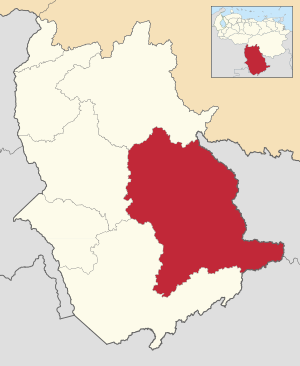
288:Alto Orinoco Municipality
274:
243:0.27/km (0.69/sq mi)
116:
102:Alto Orinoco Municipality
82:
67:
49:
40:
31:
23:Alto Orinoco Municipality
25:
298:) is one of the seven
611:State, Venezuela is a
296:Municipio Alto Orinoco
295:
26:Municipio Alto Orinoco
410:Antonio Guzmán Blanco
108:Location in Venezuela
358:improve this section
318:of Alto Orinoco is
240: • Density
132: /
232: • Total
219: • Total
136:2.9439°N 64.6933°W
624:
623:
394:
393:
386:
285:
284:
674:
645:
638:
631:
603:
596:
588:
572:
571:
565:
557:
555:
554:
548:
542:. Archived from
541:
533:
527:
526:
524:
522:
507:
501:
496:
490:
485:
479:
474:
465:
464:
462:
461:
452:. Archived from
446:
389:
382:
378:
375:
369:
338:
330:
278:edit on Wikidata
162:
160:
159:
147:
146:
144:
143:
142:
141:2.9439; -64.6933
137:
133:
130:
129:
128:
125:
98:
97:
91:
72:
57:
45:
19:
682:
681:
677:
676:
675:
673:
672:
671:
652:
651:
650:
649:
592:
586:
580:
575:
558:
552:
550:
546:
539:
537:"Archived copy"
535:
534:
530:
520:
518:
509:
508:
504:
497:
493:
486:
482:
475:
468:
459:
457:
448:
447:
443:
439:
427:
418:
390:
379:
373:
370:
355:
339:
328:
281:
157:
155:
140:
138:
134:
131:
126:
123:
121:
119:
118:
112:
111:
110:
109:
106:
105:
104:
103:
99:
78:
63:
62:
61:
60:
36:
27:
24:
17:
12:
11:
5:
680:
678:
670:
669:
664:
654:
653:
648:
647:
640:
633:
625:
622:
621:
604:
590:
589:
579:
578:External links
576:
574:
573:
528:
502:
491:
480:
466:
440:
438:
435:
426:
423:
417:
414:
392:
391:
342:
340:
333:
327:
324:
300:municipalities
283:
282:
275:
272:
271:
268:
262:
261:
251:
245:
244:
241:
237:
236:
233:
229:
228:
224:
223:
220:
216:
215:
211:
210:
203:
196:
195:
191:
190:
185:
183:Municipal seat
179:
178:
173:
167:
166:
153:
149:
148:
114:
113:
107:
101:
100:
93:
92:
86:
85:
84:
83:
80:
79:
73:
65:
64:
58:
52:
51:
50:
47:
46:
38:
37:
32:
29:
28:
22:
15:
13:
10:
9:
6:
4:
3:
2:
679:
668:
665:
663:
660:
659:
657:
646:
641:
639:
634:
632:
627:
626:
620:
618:
614:
610:
605:
602:
598:
593:
585:
582:
581:
577:
569:
563:
549:on 2006-10-02
545:
538:
532:
529:
516:
512:
506:
503:
500:
495:
492:
489:
484:
481:
478:
473:
471:
467:
456:on 2016-03-15
455:
451:
445:
442:
436:
434:
432:
424:
422:
415:
413:
411:
406:
404:
400:
388:
385:
377:
374:December 2022
367:
363:
359:
353:
352:
348:
343:This section
341:
337:
332:
331:
325:
323:
321:
317:
313:
309:
305:
301:
297:
293:
289:
279:
273:
269:
267:
259:
255:
252:
250:
242:
234:
221:
208:
205:Jaime Turon (
204:
202:
199: •
189:
186:
184:
177:
174:
172:
165:
154:
145:
117:Coordinates:
90:
77:
71:
56:
44:
35:
30:
20:
617:expanding it
606:
591:
587:(in Spanish)
551:. Retrieved
544:the original
531:
519:. Retrieved
517:(in Spanish)
514:
505:
494:
483:
458:. Retrieved
454:the original
444:
428:
419:
416:Demographics
407:
395:
380:
371:
356:Please help
344:
320:La Esmeralda
287:
286:
266:Area code(s)
188:La Esmeralda
74:Location in
34:Municipality
254:UTC−4
139: /
656:Categories
553:2008-03-15
515:cne.gob.ve
460:2016-06-15
437:References
425:Government
316:shire town
308:Venezuelan
304:municipios
227:Population
194:Government
127:64°41′36″W
403:Río Negro
345:does not
310:state of
249:Time zone
164:Venezuela
124:2°56′38″N
609:Amazonas
562:cite web
431:parishes
312:Amazonas
176:Amazonas
76:Amazonas
521:16 July
399:Orinoco
366:removed
351:sources
326:History
292:Spanish
152:Country
235:12,687
161:
547:(PDF)
540:(PDF)
276:[
201:Mayor
171:State
613:stub
568:link
523:2023
401:and
349:any
347:cite
270:0248
214:Area
59:Flag
360:by
258:VET
658::
564:}}
560:{{
513:.
469:^
322:.
294::
207:AD
644:e
637:t
630:v
619:.
570:)
556:.
525:.
463:.
387:)
381:(
376:)
372:(
368:.
354:.
302:(
290:(
280:]
260:)
256:(
209:)
Text is available under the Creative Commons Attribution-ShareAlike License. Additional terms may apply.