37:
197:
and fairly frequent flooding deposit large quantities of silty loam in much of the delta area. Windborne silt contributes to the total deposit of sediments. It has been estimated that the delta plains are built up at the rate of nearly twenty centimeters in a century. In some areas, major floods lead
209:
and poor surface and subsurface drainage tend to concentrate the salts near the surface of the soil. In general, the salinity of the soil increases from
Baghdad south to the Persian Gulf and severely limits productivity in the region south of
186:, the result of centuries of flooding and inadequate drainage. Much of it is permanent marsh, but some parts dry out in early winter, and other parts become marshland only in years of great flood.
178:, fed by the rivers in flood, also characterize southeastern Iraq. A fairly large area (15,000 km or 5,800 sq mi) just above the confluence of the two rivers at
427:
134:, although later it was shifted to a line running due west from Tikrit, thus including several towns on the Euphrates past Anbar into Iraq.
432:
338:
328:
270:
239:
397:
The Lands of the
Eastern Caliphate: Mesopotamia, Persia, and Central Asia, from the Moslem Conquest to the Time of Timur
260:
86:
and al-Jazira al-sflia ("Lower Jazira"), which strictly speaking designated only the southern alluvial plain, and
28:
292:
422:
401:
334:
266:
115:
48:
205:. These, too, are spread on the land by sometimes excessive irrigation and flooding. A high
202:
151:
64:
227:
395:
391:
354:
143:
56:
416:
223:
68:
155:
123:
91:
72:
189:
Because the waters of the Tigris and
Euphrates above their confluence are heavily
182:
and extending east of the Tigris beyond the
Iranian border is marshland, known as
206:
183:
167:
52:
36:
218:
is reflected in the large lake in central Iraq, southwest of
Baghdad, known as
194:
222:. There are two other major lakes in the country to the north of Lake Milh:
219:
179:
163:
103:
87:
17:
405:
198:
to the deposit in temporary lakes of as much as thirty centimeters of mud.
262:
Prehistory in
Northeastern Arabia – Abdullah Hassan Masry – Google Książki
114:
The medieval Arab geographers placed the northern border between Iraq and
215:
166:
lie above the level of the plain in many places, and the whole area is a
211:
159:
147:
131:
127:
171:
99:
95:
81:
35:
190:
175:
60:
201:
The Tigris and
Euphrates also carry large quantities of
170:
interlaced by the channels of the two rivers and by
8:
78:In the Middle Ages it was also known as the
374:
314:
251:
400:. New York: Barnes & Noble, Inc.
259:Masry, Abdullah Hassan (2014-09-19).
7:
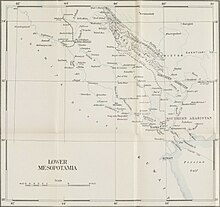
40:A map of Lower Mesopotamia from 1924
33:Region between Euphrates and Tigris
25:
240:List of Umayyad governors of Iraq
98:. Lower Mesopotamia was home to
327:Hitti, Philip K. (2002-09-26).
1:
428:Geography of the Middle East
449:
433:Historical regions of Iraq
26:
122:) in a line running from
29:Prehistory of Mesopotamia
55:. It is located in the
333:. Palgrave Macmillan.
41:
39:
330:History of the Arabs
126:on the Euphrates to
154:and extends to the
42:
377:, pp. 24–25.
116:Upper Mesopotamia
49:historical region
45:Lower Mesopotamia
16:(Redirected from
440:
409:
378:
372:
366:
365:
359:
351:
345:
344:
324:
318:
312:
306:
305:
303:
302:
297:
289:
283:
282:
280:
279:
256:
152:Hamrin Mountains
146:begins north of
90:, as opposed to
65:Hamrin Mountains
21:
448:
447:
443:
442:
441:
439:
438:
437:
413:
412:
392:Le Strange, Guy
390:
387:
382:
381:
375:Le Strange 1905
373:
369:
357:
353:
352:
348:
341:
326:
325:
321:
315:Le Strange 1905
313:
309:
300:
298:
295:
291:
290:
286:
277:
275:
273:
258:
257:
253:
248:
236:
228:Lake Habbaniyah
174:. Intermittent
140:
112:
34:
31:
23:
22:
15:
12:
11:
5:
446:
444:
436:
435:
430:
425:
415:
414:
411:
410:
386:
383:
380:
379:
367:
362:maajournal.com
346:
339:
319:
307:
284:
271:
250:
249:
247:
244:
243:
242:
235:
232:
144:alluvial plain
139:
136:
111:
108:
57:alluvial plain
32:
27:Main article:
24:
14:
13:
10:
9:
6:
4:
3:
2:
445:
434:
431:
429:
426:
424:
421:
420:
418:
407:
403:
399:
398:
393:
389:
388:
384:
376:
371:
368:
363:
356:
350:
347:
342:
340:9781137039828
336:
332:
331:
323:
320:
317:, p. 24.
316:
311:
308:
294:
288:
285:
274:
272:9781317848059
268:
265:. Routledge.
264:
263:
255:
252:
245:
241:
238:
237:
233:
231:
229:
225:
224:Lake Tharthar
221:
217:
213:
208:
204:
199:
196:
192:
187:
185:
181:
177:
173:
169:
165:
161:
157:
153:
149:
145:
137:
135:
133:
129:
125:
121:
117:
109:
107:
105:
101:
97:
93:
89:
85:
84:
83:
76:
74:
70:
69:Faw Peninsula
66:
62:
58:
54:
50:
46:
38:
30:
19:
396:
370:
361:
349:
329:
322:
310:
299:. Retrieved
287:
276:. Retrieved
261:
254:
200:
188:
156:Persian Gulf
141:
119:
113:
110:Delimitation
92:Persian Iraq
80:
79:
77:
73:Persian Gulf
44:
43:
18:Arabian Iraq
423:Mesopotamia
207:water table
184:Lake Hammar
168:river delta
158:. Here the
53:Mesopotamia
417:Categories
301:2018-04-30
293:"meso toc"
278:2018-04-30
246:References
195:irrigation
220:Lake Milh
180:al Qurnah
164:Euphrates
138:Geography
104:Babylonia
88:Arab Iraq
71:near the
63:from the
394:(1905).
234:See also
216:salinity
193:-laden,
406:1044046
385:Sources
355:"Study"
130:on the
120:Jazirah
67:to the
404:
337:
269:
214:. The
212:Amarah
160:Tigris
148:Tikrit
132:Tigris
128:Tikrit
94:, the
358:(PDF)
296:(PDF)
203:salts
176:lakes
172:qanat
150:Near
124:Anbar
118:(the
100:Sumer
96:Jibal
82:Sawad
47:is a
402:OCLC
335:ISBN
267:ISBN
226:and
191:silt
162:and
102:and
61:Iraq
142:An
59:of
51:of
419::
360:.
230:.
106:.
75:.
408:.
364:.
343:.
304:.
281:.
20:)
Text is available under the Creative Commons Attribution-ShareAlike License. Additional terms may apply.