43:
28:
185:
72:
The large Battle Point Park is in this neighborhood. It includes the Edwin E. Ritchie
Observatory, the John H. Rudolph Planetarium, the Battle Point Astronomical Association sundial, sports fields, gardens, horse corral, play structure, and other features.
114:
245:
146:
250:
226:
61:, located on the western side of the island. The northern part of the neighborhood extends to Arrow Point. Battle Point also contains the communities of
81:
219:
93:
66:
62:
124:
212:
58:
192:
47:
17:
42:
120:
50:
transmitter that was in that location during WWII for communicating with
American submarines
27:
36:
80:
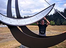
fought off a band of marauders from the north. Arrow Point, forming the western shore of
196:
239:
184:
76:
Battle Point is named for a battle in which the local
Suquamish tribe under chief
46:
The Edwin E. Ritchie
Observatory front door, with an insulator from the original
161:
148:
32:
35:
at Battle Point Park, Bainbridge Island, Washington, being admired by
77:
41:
26:
200:
116:Afoot and Afloat: South Puget Sound and Hood Canal
220:
8:
246:Communities of Bainbridge Island, Washington
227:
213:
84:, is named for its sharply pointed shape.
18:Arrow Point, Bainbridge Island, Washington
251:Kitsap County, Washington geography stubs
105:
119:. The Mountaineers Books. p. 84.
94:List of Bainbridge Island communities
7:
181:
179:
25:
183:
113:Mueller, Marge and Ted (2006).
1:
59:Bainbridge Island, Washington
199:. You can help Knowledge by
195:state location article is a
267:
178:
193:Kitsap County, Washington
162:47.662757°N 122.588589°W
48:extremely low frequency
167:47.662757; -122.588589
51:
39:
45:
30:
158: /
57:is a community of
52:
40:
33:equatorial sundial
208:
207:
16:(Redirected from
258:
229:
222:
215:
187:
180:
173:
172:
170:
169:
168:
163:
159:
156:
155:
154:
151:
138:
137:
135:
133:
110:
21:
266:
265:
261:
260:
259:
257:
256:
255:
236:
235:
234:
233:
176:
166:
164:
160:
157:
152:
149:
147:
145:
144:
142:
141:
131:
129:
127:
112:
111:
107:
102:
90:
37:Fred Sammartino
23:
22:
15:
12:
11:
5:
264:
262:
254:
253:
248:
238:
237:
232:
231:
224:
217:
209:
206:
205:
188:
140:
139:
125:
104:
103:
101:
98:
97:
96:
89:
86:
24:
14:
13:
10:
9:
6:
4:
3:
2:
263:
252:
249:
247:
244:
243:
241:
230:
225:
223:
218:
216:
211:
210:
204:
202:
198:
194:
189:
186:
182:
177:
174:
171:
128:
126:9780898869521
122:
118:
117:
109:
106:
99:
95:
92:
91:
87:
85:
83:
82:Manzanita Bay
79:
74:
70:
68:
64:
60:
56:
49:
44:
38:
34:
29:
19:
201:expanding it
190:
175:
143:
130:. Retrieved
115:
108:
75:
71:
55:Battle Point
54:
53:
165: /
153:122°35′19″W
240:Categories
150:47°39′46″N
132:25 October
100:References
88:See also
123:
78:Kitsap
67:Venice
191:This
197:stub
134:2017
121:ISBN
65:and
63:Tolo
31:The
242::
69:.
228:e
221:t
214:v
203:.
136:.
20:)
Text is available under the Creative Commons Attribution-ShareAlike License. Additional terms may apply.