197:
972:
429:
185:
173:
31:
254:
Hopkins, Jenni L.; Smid, Elaine R.; Eccles, Jennifer D.; Hayes, Josh L.; Hayward, Bruce W.; McGee, Lucy E.; van Wijk, Kasper; Wilson, Thomas M.; Cronin, Shane J.; Leonard, Graham S.; Lindsay, Jan M.; Németh, Karoly; Smith, Ian E. M. (3 July 2021). "Auckland
Volcanic Field magmatism, volcanism, and
158:. A low tuff cone with an explosion crater about 150m wide, it is now covered by industrial development. It peaked at roughly 30 metres above sea level (approximately 8 metres higher than the surrounding land).
161:
Ash Hill was named after nearby Ash Road by Searle. Ash Road was named after ash trees, not volcanic ash. Radiocarbon dating gave Ash Hill the age of 31,800 +/- 159 calendar years BP, a similar age to nearby
728:
310:
196:
63:
1013:
1042:
721:
303:
1037:
714:
235:
221:
1032:
296:
1006:
172:
890:
369:
515:
473:
184:
375:
56:
737:
999:
387:
363:
694:
682:
479:
885:
652:
644:
491:
357:
319:
151:
135:
926:
895:
759:
381:
809:
769:
934:
921:
639:
706:
622:
544:
345:
120:
900:
779:
610:
405:
971:
568:
231:
217:
983:
916:
840:
774:
670:
417:
393:
272:
264:
979:
864:
835:
616:
604:
550:
339:
333:
852:
847:
580:
574:
216:- Searle, Ernest J.; revised by Mayhill, R.D.; Longman Paul, 1981. First published 1964.
428:
857:
799:
586:
521:
509:
351:
130:
1026:
869:
794:
676:
628:
485:
467:
411:
951:
804:
764:
497:
461:
449:
163:
107:
268:
745:
664:
598:
556:
503:
399:
155:
30:
592:
78:
65:
688:
658:
455:
443:
288:
789:
741:
562:
277:
46:
35:
Likely one of few clear remains of Ash Hill, as viewed from Ash Road.
202:
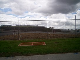
A view of part of Ash Hill before obscuring buildings were removed.
784:
814:
147:
103:
710:
292:
230:. Hayward, B.W.; Auckland University Press, 2019, 335 pp.
987:
944:
909:
878:
823:
752:
638:
531:
436:
326:
129:
119:
114:
99:
94:
55:
45:
40:
23:
249:
247:
1007:
722:
304:
257:New Zealand Journal of Geology and Geophysics
8:
1014:
1000:
729:
715:
707:
311:
297:
289:
178:A piece of Ash Hill, viewed from Oak Road.
51:30 m (98 ft)(before subdivision)
20:
276:
214:City of Volcanoes: A geology of Auckland
243:
168:
7:
968:
966:
228:Volcanoes of Auckland: A Field Guide
190:A view across present day Ash Hill.
986:. You can help Knowledge (XXG) by
14:
982:-related geography article is a
970:
427:
195:
183:
171:
29:
1043:Auckland Region geography stubs
935:Manukau City Council (defunct)
1:
665:Pupuke Moana / Pupuke Volcano
269:10.1080/00288306.2020.1736102
376:Maungakiekie / One Tree Hill
1059:
965:
879:Facilities and attractions
1038:Manurewa Local Board Area
738:Manurewa Local Board Area
425:
28:
886:Auckland Botanic Gardens
516:Ōtāhuhu / Mount Richmond
79:37.002754°S 174.867545°E
1033:Auckland volcanic field
456:Whakamuhu / Glover Park
388:Ōwairaka / Mount Albert
364:Ōhinerau / Mount Hobson
358:Maungawhau / Mount Eden
320:Auckland volcanic field
152:Auckland volcanic field
136:Auckland volcanic field
927:Manurewa-Papakura ward
896:Due Drop Events Centre
84:-37.002754; 174.867545
16:Volcano in New Zealand
922:Manurewa Local Board
891:Baitul Muqeet Mosque
824:Geographic features
545:Boggust Park Crater
382:Te Tātua a Riukiuta
346:Albert Park Volcano
255:hazard: a review".
75: /
901:Southmall Manurewa
41:Highest point
995:
994:
960:
959:
704:
703:
640:Waitematā Harbour
141:
140:
1050:
1016:
1009:
1002:
974:
967:
917:Auckland Council
841:Pahurehure Inlet
775:Goodwood Heights
753:Populated places
731:
724:
717:
708:
623:Māngere Mountain
431:
418:Little Rangitoto
394:Te Hopua a Rangi
370:Mount Saint John
334:Pukekawa Volcano
327:Central Auckland
313:
306:
299:
290:
283:
282:
280:
263:(2–3): 213–234.
251:
199:
187:
175:
146:is a volcano in
90:
89:
87:
86:
85:
80:
76:
73:
72:
71:
68:
33:
21:
1058:
1057:
1053:
1052:
1051:
1049:
1048:
1047:
1023:
1022:
1021:
1020:
980:Auckland Region
963:
961:
956:
940:
905:
874:
865:Papakura Stream
836:Manukau Harbour
819:
748:
735:
705:
700:
642:
634:
617:Puketutu Island
605:Puhinui Craters
551:Cemetery Crater
527:
474:Pigeon Mountain
432:
423:
340:Grafton Volcano
322:
317:
287:
286:
253:
252:
245:
210:
203:
200:
191:
188:
179:
176:
83:
81:
77:
74:
69:
66:
64:
62:
61:
36:
17:
12:
11:
5:
1056:
1054:
1046:
1045:
1040:
1035:
1025:
1024:
1019:
1018:
1011:
1004:
996:
993:
992:
975:
958:
957:
955:
954:
948:
946:
942:
941:
939:
938:
931:
930:
929:
924:
913:
911:
907:
906:
904:
903:
898:
893:
888:
882:
880:
876:
875:
873:
872:
867:
862:
861:
860:
858:Wiri Lava Cave
850:
845:
844:
843:
833:
827:
825:
821:
820:
818:
817:
812:
807:
802:
800:Totara Heights
797:
792:
787:
782:
777:
772:
767:
762:
756:
754:
750:
749:
736:
734:
733:
726:
719:
711:
702:
701:
699:
698:
692:
686:
683:Mount Victoria
680:
674:
668:
662:
656:
649:
647:
636:
635:
633:
632:
626:
620:
614:
608:
602:
596:
590:
587:Maungataketake
584:
578:
572:
569:Māngere Lagoon
566:
560:
554:
548:
542:
535:
533:
532:South Auckland
529:
528:
526:
525:
522:Robertson Hill
519:
513:
510:McLennan Hills
507:
501:
495:
489:
483:
477:
471:
465:
459:
453:
447:
440:
438:
434:
433:
426:
424:
422:
421:
415:
409:
403:
397:
391:
385:
379:
373:
367:
361:
355:
352:Te Pou Hawaiki
349:
343:
337:
330:
328:
324:
323:
318:
316:
315:
308:
301:
293:
285:
284:
242:
241:
240:
239:
225:
209:
206:
205:
204:
201:
194:
192:
189:
182:
180:
177:
170:
139:
138:
133:
131:Volcanic field
127:
126:
123:
117:
116:
112:
111:
101:
97:
96:
92:
91:
59:
53:
52:
49:
43:
42:
38:
37:
34:
26:
25:
15:
13:
10:
9:
6:
4:
3:
2:
1055:
1044:
1041:
1039:
1036:
1034:
1031:
1030:
1028:
1017:
1012:
1010:
1005:
1003:
998:
997:
991:
989:
985:
981:
976:
973:
969:
964:
953:
950:
949:
947:
945:Organisations
943:
937:
936:
932:
928:
925:
923:
920:
919:
918:
915:
914:
912:
908:
902:
899:
897:
894:
892:
889:
887:
884:
883:
881:
877:
871:
870:Puhinui Creek
868:
866:
863:
859:
856:
855:
854:
851:
849:
846:
842:
839:
838:
837:
834:
832:
829:
828:
826:
822:
816:
813:
811:
808:
806:
803:
801:
798:
796:
795:Randwick Park
793:
791:
788:
786:
783:
781:
778:
776:
773:
771:
768:
766:
763:
761:
758:
757:
755:
751:
747:
743:
739:
732:
727:
725:
720:
718:
713:
712:
709:
696:
693:
690:
687:
684:
681:
678:
677:Mount Cambria
675:
672:
669:
666:
663:
660:
657:
654:
651:
650:
648:
646:
641:
637:
630:
629:Pukaki Lagoon
627:
624:
621:
618:
615:
612:
609:
606:
603:
600:
597:
594:
591:
588:
585:
582:
579:
576:
573:
570:
567:
564:
561:
558:
555:
552:
549:
546:
543:
540:
537:
536:
534:
530:
523:
520:
517:
514:
511:
508:
505:
502:
499:
496:
493:
490:
487:
484:
481:
478:
475:
472:
469:
468:Panmure Basin
466:
463:
460:
457:
454:
451:
448:
445:
442:
441:
439:
437:East Auckland
435:
430:
419:
416:
413:
410:
407:
404:
401:
398:
395:
392:
389:
386:
383:
380:
377:
374:
371:
368:
365:
362:
359:
356:
353:
350:
347:
344:
341:
338:
335:
332:
331:
329:
325:
321:
314:
309:
307:
302:
300:
295:
294:
291:
279:
274:
270:
266:
262:
258:
250:
248:
244:
237:
236:0-582-71784-1
233:
229:
226:
223:
222:0-582-71784-1
219:
215:
212:
211:
207:
198:
193:
186:
181:
174:
169:
167:
165:
164:Wiri Mountain
159:
157:
153:
149:
145:
137:
134:
132:
128:
124:
122:
118:
113:
110:, New Zealand
109:
105:
102:
98:
93:
88:
60:
58:
54:
50:
48:
44:
39:
32:
27:
22:
19:
988:expanding it
977:
962:
952:Manurewa AFC
933:
853:Matukutūruru
848:Matukutūreia
830:
805:Wattle Downs
765:Clendon Park
581:Matukutūruru
575:Matukutūreia
538:
498:Styaks Swamp
480:Hampton Park
462:Taylors Hill
450:Purchas Hill
406:Ōrākei Basin
260:
256:
227:
213:
160:
143:
142:
125:31,800 years
108:North Island
18:
770:The Gardens
746:New Zealand
645:North Shore
557:Crater Hill
504:Pukewairiki
400:Mount Smart
156:New Zealand
121:Age of rock
82: /
70:174°52′03″E
57:Coordinates
1027:Categories
910:Government
653:Maungauika
593:Waitomokia
492:Green Hill
486:Ōtara Hill
412:Puketāpapa
278:2292/51323
208:References
67:37°00′10″S
760:Alfriston
689:Tank Farm
671:Rangitoto
659:Motukorea
444:Maungarei
150:, in the
95:Geography
47:Elevation
831:Ash Hill
810:Weymouth
790:Manurewa
780:Hillpark
742:Auckland
599:Ōtuataua
539:Ash Hill
144:Ash Hill
100:Location
24:Ash Hill
695:Onepoto
611:Pukeiti
563:Kohuora
115:Geology
234:
220:
978:This
785:Homai
154:, in
984:stub
815:Wiri
643:and
631:(44)
625:(37)
619:(39)
613:(41)
607:(53)
601:(42)
595:(40)
589:(43)
583:(48)
577:(47)
571:(38)
565:(46)
559:(45)
553:(52)
547:(51)
541:(49)
524:(30)
518:(28)
512:(29)
506:(31)
500:(35)
494:(34)
488:(33)
482:(32)
476:(36)
470:(25)
464:(22)
458:(21)
452:(23)
446:(24)
420:(19)
414:(14)
408:(20)
402:(26)
396:(27)
390:(13)
384:(15)
378:(16)
372:(17)
366:(18)
360:(11)
354:(12)
342:(50)
336:(10)
232:ISBN
218:ISBN
148:Wiri
104:Wiri
697:(3)
691:(2)
685:(4)
679:(5)
673:(7)
667:(1)
661:(8)
655:(6)
348:(9)
273:hdl
265:doi
1029::
744:,
740:,
271:.
261:64
259:.
246:^
166:.
106:,
1015:e
1008:t
1001:v
990:.
730:e
723:t
716:v
312:e
305:t
298:v
281:.
275::
267::
238:.
224:.
Text is available under the Creative Commons Attribution-ShareAlike License. Additional terms may apply.