545:
536:
561:
527:
518:
509:
139:. Sections of this border were demarcated and marked on the ground from 1897 to 1900. In 1941, a border running through the Wa States area was agreed upon following on-the-ground surveys conducted in the 1930s, though no agreement on the northern stretch was reached, with China claiming much of what is now northern Myanmar. Meanwhile, in 1937, Burma was separated from India and became a separate colony, gaining full independence in 1948.
107:
31:
1576:
575:
311:
301:
through a "compromise-oriented border control." China implemented flexible migration for
Burmese workers while implementing surveillance, policing and other enforcement tactics in border cities instead of only at the border. Burmese migrants in Chinese border cities live and work within China but
194:
troops. On 28 January 1960, a treaty was signed which delimited most of the border, which was later completed with a full delimitation treaty signed on 1 October 1960, with both sides ceding small areas along the border, such as areas around
90:, which it utilises for a period towards the north-east. The border then continues through mountainous terrain in a broadly (though often convoluted) south-eastwards direction, occasionally utilising rivers (such as the Nanding and
122:
The boundary area is inhabited by non-Han and non-Burmese peoples, and has been traditionally kept as a buffer region between the various
Chinese and Burmese empires. During the 19th century the British, based in India, began
131:. Their advance close to lands traditionally claimed by China pushed the two sides into negotiating a boundary treaty in 1894, which covered the southern half of the boundary as far north as the vicinity of
1191:
274:
Since finalizing the border, relations between the two states have remained largely cordial, though the border region has at times been volatile owing to the ongoing insurgencies in
Myanmar's
297:
The border is porous as a militarized strict border control was controversial prior to 2020. Burmese migrant workers are included within the economy of
Chinese border cities in
187:
250:
1184:
207:, which China recognized most of the disputed territory belonging to Burma, while Burma relinquishing small amount of that disputed territory, namely Hpimaw (Pianma) (
1523:
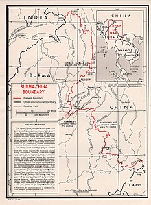
1177:
1279:
1368:
1099:
1106:
779:
Agreement on the
Question of the Boundary signed on January 28, 1960...(b) the villages of Hpimaw, Gawlum, and Kangfang would be Chinese;...(d) the
931:
906:
881:
186:
Discussions between Burma and China over the border began in 1954, with China keen to control the area more effectively as it was being used as
969:
1605:
816:
752:
685:
1064:
1051:
1600:
337:
1516:
464:
1620:
1361:
499:
1541:
1025:
993:
1085:
1439:
1394:
544:
480:
279:
1561:
1454:
1414:
1409:
593:
535:
1615:
1509:
162:
territory, thereby giving border with
Thailand. These areas were returned to Burma in 1946 following Japan's defeat.
618:
263:
to China. The two sides then demarcated the border on the ground in the following year. The border ran through the
155:
1444:
1424:
1610:
1354:
1551:
1459:
961:
151:
1556:
1449:
1399:
1110:
1478:
588:
1434:
1404:
42:
is the international border between the territory of the People's
Republic of China and Myanmar (formerly
1419:
860:
790:
598:
246:
181:
124:
942:
917:
892:
1483:
1003:
1135:
1490:
437:
75:
1322:
1269:
1155:
975:
71:
526:
517:
508:
1328:
1079:
965:
827:
763:
692:
159:
1065:"Asia Times Online :: south-east Asia news – Virtual gambling in Myanmar's drug country"
1377:
1334:
1147:
1136:"Space of Compromise: Border Control and the Limited Inclusion of Burmese Migrants in China"
1029:
256:
143:
1242:
716:
642:
298:
275:
260:
106:
70:. It then turns to the south-east, running broadly south and then south-west across the
1580:
1227:
580:
400:
67:
30:
255:
from China to Burma) would become part of Burma legally, in exchange for Burma ceding
1594:
1260:
1159:
421:
330:
291:
128:
979:
1288:
998:
887:[Xiapianma Village, Pianma Village Committee, Pianma Town, Lushui County].
566:
349:
Mangxin crossing (Menglian County, Pu'er
Prefecture) – NDAA control on Burmese side
196:
171:
87:
83:
63:
1151:
310:
150:
was constructed across the border as an Allied supply line for the
Chinese forces
17:
1169:
1217:
382:
315:
1284:
1212:
556:
412:
200:
191:
175:
147:
59:
302:
endure economic exploitation, spatial confinement and social discrimination.
1316:
483:
border force joint control) – Houqiao (Tengchong County, Baoshan
Prefecture)
476:
268:
264:
204:
136:
132:
58:
The border begins in the north at the tripoint with India just north of the
843:
Agreement on the Question of the Boundary signed on January 28, 1960...(b)
46:). The border is 2,129 km (1,323 mi) in length and runs from the
486:
Pang War (NDA-K border force joint control) – Diantan (Tengchong, Baoshan)
1275:
370:
360:
356:
352:
47:
1255:
1251:
1247:
1238:
1232:
1223:
850:
780:
441:
431:
406:
392:
343:
283:
111:
91:
1501:
854:
784:
617:
The precise location of the tripoint is unclear owing to the ongoing
396:
386:
376:
115:
95:
294:, have become centres of gambling, prostitution and drug smuggling.
1346:
1310:
1304:
1264:
1067:. Atimes.com. 2006-08-26. Archived from the original on 2006-10-19
937:[Gangfang Village Committee, Pianma Town, Lushui County].
823:
759:
470:
457:
425:
309:
287:
105:
79:
29:
912:[Gulang Village Committee, Pianma Town, Lushui County].
282:
states. In recent years several towns along the border, such as
50:
with India in the north to the tripoint with Laos in the south.
1505:
1350:
1173:
958:
Stalemate: Autonomy and Insurgency on the China-Myanmar Border
846:
the villages of Hpimaw, Gawlum, and Kangfang would be Chinese;
127:(then referred to as Burma), gradually incorporating it into
817:"International Boundary Study No. 42 – Burma-China Boundary"
753:"International Boundary Study No. 42 – Burma-China Boundary"
686:"International Boundary Study No. 42 – Burma-China Boundary"
62:
and then runs briefly north-east, across the Nanmi Pass and
1100:"Strategic Programme Framework: Union of Myanmar 2004–2007"
366:
Natuoba (Wa State) – Mengka crossing (Ximeng County, Pu'er)
882:"Lúshuǐ Xiàn Piànmǎ Zhèn Piànmǎ Cūnwěihuì Xiàpiànmǎ Cūn"
869:, the 1941 boundary in the Wa states would be accepted...
498:
Historical maps of the border from north to south in the
118:(Panglao) townships as a result of the 1960 border treaty
86:
and Nanwan rivers, before turning south-east to join the
740:
403:(Zhenkang County, Lincang), incl. Yan Lon Kyaing passage
802:
the 1941 boundary in the Wa states would be accepted...
741:"A Forgotten Invasion: Thailand in Shan State, 1941–45"
473:(controlled by KIO) – Nabang (Yingjiang County, Dehong)
110:
Close-up map of areas ceded to China: Pianma (Hpimaw),
346:(NDAA control) – Daluo (Menghai County, Xishuangbanna)
428:(including Nantaw, Mang Wein, and Sin Phyu passages)
78:
via a series of irregular lines. In the vicinity of
1468:
1384:
1297:
1205:
489:
Hpimaw – Pianma (Lushui County, Nujiang Prefecture)
336:Menglong crossing (Jinghong City, Xishuangbanna) –
158:of Burma, parts of Burma were ceded to Siam as the
1026:"Myanmar says Chinese tip-off led to border clash"
1140:Annals of the American Association of Geographers
267:, although it had little practical effect on the
1054:, Michael Black and Roland Fields, Aug 26, 2006
994:"More fighting feared as thousands flee Burma"
1517:
1362:
1185:
932:"Lúshuǐ Xiàn Piànmǎ Zhèn Gǎngfáng Cūnwěihuì"
418:Kyin San Kyawt (Jinsanjiao) – Wanding Mangman
409:– Manghai (Mangshi County, Dehong Prefecture)
8:
94:) for short stretches, before following the
907:"Lúshuǐ Xiàn Piànmǎ Zhèn Gǔlàng Cūnwěihuì"
717:Burma Road – Britannica Online Encyclopedia
1524:
1510:
1502:
1369:
1355:
1347:
1192:
1178:
1170:
1052:Virtual gambling in Myanmar's drug country
691:. US DOS. 30 November 1964. Archived from
1134:Su, Xiaobo; Cai, Xiaomei (13 June 2019).
415:(Kyukok) – Wanding (Ruili County, Dehong)
82:the border briefly utilises parts of the
1107:United Nations Office on Drugs and Crime
729:Historical Dictionary of Burma (Myanmar)
634:
610:
504:
379:(Wa State) – Mangka (Cangyuan, Lincang)
1077:
680:
460:– Zhangfeng (Longchuan County, Dehong)
373:, Cangyuan County, Lincang Prefecture)
678:
676:
674:
672:
670:
668:
666:
664:
662:
660:
369:Shawba (Wa State) – Yonghe crossing (
7:
463:Mai Ja Yang crossing (controlled by
329:Guanlei River Port (Mengla County,
66:(5,881 m), the highest mountain in
826:. 30 November 1964. Archived from
762:. 30 November 1964. Archived from
154:Japan. In 1941, following Japan's
25:
1574:
865:; and (e) with the exception of
795:; and (e) with the exception of
573:
559:
543:
534:
525:
516:
507:
245:) to PRC. They also agreed that
221:) and adjacent Gawlam (Gulang) (
857:tribal area would be exchanged
787:tribal area would be exchanged
34:Map of the China-Myanmar border
1200:China–Myanmar border crossings
500:International Map of the World
241:
236:
232:
227:
217:
212:
208:
1:
1152:10.1080/24694452.2019.1644989
941:(in Chinese). Archived from
916:(in Chinese). Archived from
891:(in Chinese). Archived from
98:to the tripoint with Laos.
1637:
619:Sino-Indian border dispute
179:
169:
1570:
1537:
1084:: CS1 maint: unfit URL (
502:, mid-late 20th century:
222:
962:Cornell University Press
933:
908:
883:
446:Leiyun passage (Nongdao)
1606:China–Myanmar relations
594:China–Myanmar relations
589:Ports of entry of China
434:– Yinjing (open border)
340:control on Burmese side
319:
119:
35:
1621:International borders
599:Namwan Assigned Tract
313:
182:Namwan Assigned Tract
109:
33:
1601:China–Myanmar border
1484:Frontier Closed Area
1004:Agence France-Presse
980:10.7591/j.ctv2t8b78b
956:Ong, Andrew (2023).
645:. CIA World Factbook
40:China–Myanmar border
27:International border
1298:Yunnan–Kachin State
1050:Asia Times Online,
1032:. 10 September 2009
727:Donald M. Seekins,
135:, exclusive of the
76:Gaoligong Mountains
1616:Borders of Myanmar
1581:Myanmar portal
1532:Borders of Myanmar
833:on 31 January 2020
769:on 31 January 2020
698:on 31 January 2020
320:
166:1960 border treaty
120:
36:
18:Burma–China border
1588:
1587:
1499:
1498:
1487:
1344:
1343:
1206:Yunnan–Shan State
971:978-1-5017-7071-5
314:A border gate at
252:"perpetual lease"
160:Saharat Thai Doem
125:occupying Myanmar
16:(Redirected from
1628:
1611:Borders of China
1579:
1578:
1577:
1526:
1519:
1512:
1503:
1481:
1378:Borders of China
1371:
1364:
1357:
1348:
1194:
1187:
1180:
1171:
1164:
1163:
1131:
1125:
1124:
1122:
1121:
1115:
1109:. Archived from
1104:
1096:
1090:
1089:
1083:
1075:
1073:
1072:
1061:
1055:
1048:
1042:
1041:
1039:
1037:
1030:Associated Press
1022:
1016:
1015:
1013:
1011:
1006:. 27 August 2009
990:
984:
983:
953:
947:
946:
928:
922:
921:
903:
897:
896:
878:
872:
871:
840:
838:
832:
821:
813:
807:
806:
776:
774:
768:
757:
749:
743:
738:
732:
725:
719:
714:
708:
707:
705:
703:
697:
690:
682:
655:
654:
652:
650:
639:
622:
615:
583:
578:
577:
576:
569:
564:
563:
562:
547:
538:
529:
520:
511:
389:County, Lincang)
306:Border crossings
257:Panghung/Banhong
243:
238:
234:
231:) and Kangfang (
229:
224:
219:
214:
210:
144:Second World War
21:
1636:
1635:
1631:
1630:
1629:
1627:
1626:
1625:
1591:
1590:
1589:
1584:
1575:
1573:
1566:
1533:
1530:
1500:
1495:
1464:
1380:
1375:
1345:
1340:
1293:
1201:
1198:
1168:
1167:
1133:
1132:
1128:
1119:
1117:
1113:
1102:
1098:
1097:
1093:
1076:
1070:
1068:
1063:
1062:
1058:
1049:
1045:
1035:
1033:
1024:
1023:
1019:
1009:
1007:
992:
991:
987:
972:
955:
954:
950:
935:
930:
929:
925:
910:
905:
904:
900:
885:
884:泸水县片马镇片马村委会下片马村
880:
879:
875:
836:
834:
830:
819:
815:
814:
810:
772:
770:
766:
755:
751:
750:
746:
739:
735:
726:
722:
715:
711:
701:
699:
695:
688:
684:
683:
658:
648:
646:
641:
640:
636:
631:
626:
625:
616:
612:
607:
579:
574:
572:
565:
560:
558:
555:
548:
539:
530:
521:
512:
496:
494:Historical maps
355:(controlled by
308:
299:Yunnan Province
184:
178:
170:Main articles:
168:
114:(Panghung) and
104:
56:
28:
23:
22:
15:
12:
11:
5:
1634:
1632:
1624:
1623:
1618:
1613:
1608:
1603:
1593:
1592:
1586:
1585:
1571:
1568:
1567:
1565:
1564:
1559:
1554:
1549:
1544:
1538:
1535:
1534:
1531:
1529:
1528:
1521:
1514:
1506:
1497:
1496:
1494:
1493:
1488:
1475:
1473:
1466:
1465:
1463:
1462:
1457:
1452:
1447:
1442:
1437:
1432:
1427:
1422:
1417:
1412:
1407:
1402:
1397:
1391:
1389:
1382:
1381:
1376:
1374:
1373:
1366:
1359:
1351:
1342:
1341:
1339:
1338:
1332:
1326:
1320:
1314:
1308:
1301:
1299:
1295:
1294:
1292:
1291:
1282:
1273:
1267:
1258:
1245:
1236:
1230:
1221:
1215:
1209:
1207:
1203:
1202:
1199:
1197:
1196:
1189:
1182:
1174:
1166:
1165:
1146:(3): 847-863.
1126:
1091:
1056:
1043:
1017:
985:
970:
948:
945:on 2015-04-02.
923:
920:on 2015-04-03.
898:
895:on 2015-04-02.
873:
808:
744:
733:
720:
709:
656:
633:
632:
630:
627:
624:
623:
609:
608:
606:
603:
602:
601:
596:
591:
585:
584:
581:Myanmar portal
570:
554:
551:
550:
549:
542:
540:
533:
531:
524:
522:
515:
513:
506:
495:
492:
491:
490:
487:
484:
474:
468:
461:
448:
447:
444:
435:
429:
419:
416:
410:
404:
390:
385:– Qingshuihe (
380:
374:
367:
364:
363:County, Pu'er)
350:
347:
341:
334:
318:, Kachin State
307:
304:
261:Panglao/Banlao
249:(which was in
167:
164:
103:
100:
68:Southeast Asia
55:
52:
26:
24:
14:
13:
10:
9:
6:
4:
3:
2:
1633:
1622:
1619:
1617:
1614:
1612:
1609:
1607:
1604:
1602:
1599:
1598:
1596:
1583:
1582:
1569:
1563:
1560:
1558:
1555:
1553:
1550:
1548:
1545:
1543:
1540:
1539:
1536:
1527:
1522:
1520:
1515:
1513:
1508:
1507:
1504:
1492:
1489:
1485:
1480:
1477:
1476:
1474:
1471:
1467:
1461:
1458:
1456:
1453:
1451:
1448:
1446:
1443:
1441:
1438:
1436:
1433:
1431:
1428:
1426:
1423:
1421:
1418:
1416:
1413:
1411:
1408:
1406:
1403:
1401:
1398:
1396:
1393:
1392:
1390:
1387:
1386:International
1383:
1379:
1372:
1367:
1365:
1360:
1358:
1353:
1352:
1349:
1336:
1333:
1330:
1327:
1324:
1321:
1318:
1315:
1312:
1309:
1306:
1303:
1302:
1300:
1296:
1290:
1286:
1283:
1281:
1277:
1274:
1271:
1268:
1266:
1262:
1259:
1257:
1253:
1249:
1246:
1244:
1240:
1237:
1234:
1231:
1229:
1225:
1222:
1219:
1216:
1214:
1211:
1210:
1208:
1204:
1195:
1190:
1188:
1183:
1181:
1176:
1175:
1172:
1161:
1157:
1153:
1149:
1145:
1141:
1137:
1130:
1127:
1116:on 2005-05-03
1112:
1108:
1101:
1095:
1092:
1087:
1081:
1066:
1060:
1057:
1053:
1047:
1044:
1031:
1027:
1021:
1018:
1005:
1001:
1000:
995:
989:
986:
981:
977:
973:
967:
963:
959:
952:
949:
944:
940:
939:ynszxc.gov.cn
936:
927:
924:
919:
915:
914:ynszxc.gov.cn
911:
902:
899:
894:
890:
889:ynszxc.gov.cn
886:
877:
874:
870:
868:
864:
862:
856:
852:
848:
847:
829:
825:
818:
812:
809:
805:
804:
803:
798:
794:
792:
786:
782:
765:
761:
754:
748:
745:
742:
737:
734:
730:
724:
721:
718:
713:
710:
694:
687:
681:
679:
677:
675:
673:
671:
669:
667:
665:
663:
661:
657:
644:
638:
635:
628:
620:
614:
611:
604:
600:
597:
595:
592:
590:
587:
586:
582:
571:
568:
557:
552:
546:
541:
537:
532:
528:
523:
519:
514:
510:
505:
503:
501:
493:
488:
485:
482:
478:
475:
472:
469:
466:
462:
459:
456:
455:
454:
452:
445:
443:
439:
436:
433:
430:
427:
423:
420:
417:
414:
411:
408:
405:
402:
398:
394:
391:
388:
384:
381:
378:
375:
372:
368:
365:
362:
358:
354:
351:
348:
345:
342:
339:
335:
332:
331:Xishuangbanna
328:
327:
326:
324:
317:
312:
305:
303:
300:
295:
293:
289:
285:
281:
277:
272:
270:
266:
262:
258:
254:
253:
248:
244:
230:
220:
206:
202:
198:
193:
189:
183:
177:
173:
165:
163:
161:
157:
153:
149:
145:
140:
138:
134:
130:
129:British India
126:
117:
113:
108:
101:
99:
97:
93:
89:
85:
81:
77:
73:
69:
65:
61:
53:
51:
49:
45:
41:
32:
19:
1572:
1546:
1469:
1429:
1385:
1235:–Yinjingzhai
1143:
1139:
1129:
1118:. Retrieved
1111:the original
1094:
1069:. Retrieved
1059:
1046:
1036:11 September
1034:. Retrieved
1020:
1008:. Retrieved
999:Bangkok Post
997:
988:
957:
951:
943:the original
938:
926:
918:the original
913:
901:
893:the original
888:
876:
866:
858:
845:
844:
842:
837:17 September
835:. Retrieved
828:the original
811:
801:
800:
796:
788:
778:
773:17 September
771:. Retrieved
764:the original
747:
736:
728:
723:
712:
702:17 September
700:. Retrieved
693:the original
649:17 September
647:. Retrieved
637:
613:
567:China portal
497:
451:Kachin State
450:
449:
359:) – Meng'a (
322:
321:
296:
273:
251:
240:
226:
216:
197:Kachin Hills
185:
172:Kachin Hills
141:
121:
96:Mekong River
88:Shweli River
64:Hkakabo Razi
57:
43:
39:
37:
1440:North Korea
1395:Afghanistan
1323:Mai Ja Yang
1220:–Qingshuihe
1218:Chinshwehaw
934:泸水县片马镇岗房村委会
909:泸水县片马镇古浪村委会
849:...(d) the
383:Chinshwehaw
316:Kan Paik Ti
247:Namwan area
142:During the
54:Description
1595:Categories
1542:Bangladesh
1455:Tajikistan
1415:Kyrgyzstan
1410:Kazakhstan
1325:–Zhangfeng
1307:–Zhangfeng
1285:Pang Hseng
1213:Diphu Pass
1120:2009-01-01
1071:2012-11-29
629:References
413:Pang Hseng
399:Region) –
323:Shan State
201:Jiangxinpo
192:Kuomintang
180:See also:
176:Jiangxinpo
148:Burma Road
60:Diphu Pass
1479:Hong Kong
1317:Kanpaikti
1160:204435944
1010:28 August
605:Footnotes
477:Kanpaikti
269:Wa people
265:Wa region
205:Wa States
137:Wa States
133:Myitkyina
1562:Thailand
1470:Internal
1445:Pakistan
1425:Mongolia
1331:–Diantan
1329:Pang War
1319:–Houqiao
1280:Menglian
1276:Pangkham
1080:cite web
731:, p. 251
553:See also
371:Mengdong
361:Menglian
357:Wa State
353:Pangkham
242:Gǎngfáng
156:invasion
152:fighting
72:Hengduan
48:tripoint
1460:Vietnam
1430:Myanmar
1337:–Pianma
1313:–Nabang
1289:Wanding
1272:–Mangka
1256:Mangshi
1252:Manghai
1248:Mong Ko
1239:Mong La
1233:Manhero
1224:Laukkai
851:Panhung
781:Panhung
643:"Burma"
442:Nongdao
438:Namhkam
432:Manhero
407:Mong Ko
393:Laukkai
344:Mong La
284:Mong La
112:Banhong
102:History
92:Nam Hka
1450:Russia
1400:Bhutan
1335:Hpimaw
1270:Namtit
1228:Nansan
1158:
978:
968:
861:Namwan
855:Panlao
791:Namwan
785:Panlao
401:Nansan
397:Kokang
387:Gengma
377:Namtit
276:Kachin
228:Gǔlàng
218:Piànmǎ
188:a base
146:, the
116:Banlao
84:Taping
1552:India
1547:China
1491:Macau
1435:Nepal
1405:India
1311:Laiza
1305:Lweje
1265:Ruili
1243:Daluo
1156:S2CID
1114:(PDF)
1103:(PDF)
976:JSTOR
859:(for
831:(PDF)
824:USDOS
820:(PDF)
789:(for
767:(PDF)
760:USDOS
756:(PDF)
696:(PDF)
689:(PDF)
481:NDA-K
471:Laiza
458:Lweje
426:Ruili
288:Ruili
80:Ruili
44:Burma
1557:Laos
1420:Laos
1261:Muse
1086:link
1038:2009
1012:2009
966:ISBN
839:2020
775:2020
704:2020
651:2020
422:Muse
338:NDAA
292:Muse
290:and
280:Shan
278:and
259:and
203:and
174:and
74:and
38:The
1148:doi
1144:110
465:KIO
453::
325::
190:by
1597::
1254:,
1154:.
1142:.
1138:.
1105:.
1082:}}
1078:{{
1028:.
1002:.
996:.
974:.
964:.
960:.
841:.
822:.
799:,
777:.
758:.
659:^
440:–
424:–
286:,
271:.
239:;
237:岗房
235:;
233:崗房
225:;
223:古浪
215:;
213:片马
211:;
209:片馬
1525:e
1518:t
1511:v
1486:)
1482:(
1472::
1388::
1370:e
1363:t
1356:v
1287:–
1278:–
1263:–
1250:–
1241:–
1226:–
1193:e
1186:t
1179:v
1162:.
1150::
1123:.
1088:)
1074:.
1040:.
1014:.
982:.
867:d
863:)
853:-
797:d
793:)
783:-
706:.
653:.
621:.
479:(
467:)
395:(
333:)
199:/
20:)
Text is available under the Creative Commons Attribution-ShareAlike License. Additional terms may apply.