31:
47:
54:
412:
357:
in
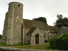
Suffolk. The church tower is believed to be Saxon in origin, although the present tower has been dated to the 13th century. The building was heavily restored in the 19th century. The church is not mentioned in the Domesday Book entry for the village.
366:
Beyton Middle School enrolled about 700 pupils from age 9 to 13 with the majority of students coming from surrounding villages. The school closed in July 2014 as part of a reorganisation of schools to a two tier structure by
333:
Beyton Parish
Council made both local and national news in 2015 after the chairman's wife blocked a member of the public legally filming a council meeting. The police were called to the scene.
104:
479:
496:
307:
of 1086 as
Begoton or Begatona. The Domesday village was held by Hugh de Montfort and was a very small settlement with a taxable value of just 0.3 geld units.
310:
The village was a farming community located on the glacial clay of 'High' Suffolk. It grew up around the village green and the along the main
326:
running to the north of the village. A maltings was present in the village in 1855 and a post mill, which had originally been located at
580:
380:
546:
476:
219:
200:
176:
140:
46:
575:
570:
585:
528:
322:
in 1711 and became an accident 'black spot' in modern times. The village having been bypassed in 1978 with the modern
30:
372:
371:
that saw students stay in primary school to age 11 where they would then transfer on to secondary schools, mostly
210:
205:
323:
288:
154:
376:
368:
86:
303:
the meaning of the name is homestead by brook or Beaga's homestead. The village is mentioned in the
354:
122:
497:"Video: Police called to Beyton Parish Council due to a villager's attempts to film councillors"
330:, was moved to the village in 1830. A conservation area was established in the village in 1973.
276:
181:
483:
383:. The site is now used by Thurston Community College as part of its sixth form provision.
350:
315:
272:
169:
130:
510:
264:
564:
392:
304:
300:
327:
256:
260:
94:
453:
441:
429:
280:
234:
221:
319:
164:
311:
284:
268:
146:
112:
67:
287:
to Bury St
Edmunds road used to pass through the village – the modern
341:
Beyton parish forms part of the Mid
Suffolk district.
271:. The village is around 8 miles (13 km) east of
175:
163:
153:
139:
121:
103:
85:
77:
23:
549:, British Listed Buildings. Retrieved 2016-04-09.
511:"Police called over geese debate filming dispute"
432:, Suffolk Churches website. Retrieved 2016-04-09.
444:, Domesday Baook Online. Retrieved 2016-04-09.
425:
423:
421:
349:The parish church, All Saints, is a Grade II*
8:
542:
540:
538:
468:
466:
464:
462:
529:"Row over geese sends village into a flap"
20:
475:, Mid Suffolk District Council, 2009. (
405:
395:(1863–1934), cricketer and army officer
279:and 8 miles (13 km) north-west of
162:
138:
27:
456:, Open Domesday. Retrieved 2016-04-09.
275:, 2 miles (3.2 km) south-east of
174:
152:
120:
102:
84:
7:
291:bypasses the village to the north.
381:Bury St Edmunds County High School
14:
52:
45:
29:
53:
1:
547:Church of All Saints, Beyton
413:Civil Parish population 2011
531:. ITV plc. 13 January 2015.
473:Conservation Area Appraisal
353:. It is one of 38 existing
18:Human settlement in England
602:
373:Thurston Community College
35:All Saints’ Church, Beyton
581:Civil parishes in Suffolk
191:
187:
40:
28:
486:), retrieved 2016-04-09.
415:. Retrieved 2016-08-16.
377:Stowupland High School
369:Suffolk County Council
177:Postcode district
81:713 (2011 census)
576:Mid Suffolk District
355:round-tower churches
289:A14 dual carriageway
155:Sovereign state
571:Villages in Suffolk
318:road. The road was
231: /
586:Thedwastre Hundred
517:. 13 January 2015.
499:. 13 January 2015.
482:2016-04-21 at the
430:All Saints, Beyton
345:All Saints’ Church
255:is a village and
250:
249:
105:Shire county
593:
550:
544:
533:
532:
525:
519:
518:
507:
501:
500:
493:
487:
477:Available online
470:
457:
451:
445:
439:
433:
427:
416:
410:
263:district of the
246:
245:
243:
242:
241:
236:
235:52.233°N 0.833°E
232:
229:
228:
227:
224:
197:
149:
66:Location within
56:
55:
49:
33:
21:
601:
600:
596:
595:
594:
592:
591:
590:
561:
560:
559:
554:
553:
545:
536:
527:
526:
522:
509:
508:
504:
495:
494:
490:
484:Wayback Machine
471:
460:
452:
448:
440:
436:
428:
419:
411:
407:
402:
389:
364:
351:listed building
347:
339:
316:Bury St Edmunds
297:
273:Bury St Edmunds
239:
237:
233:
230:
225:
222:
220:
218:
217:
215:
195:
170:Bury St Edmunds
145:
135:
117:
99:
73:
72:
71:
70:
64:
63:
62:
61:
57:
36:
19:
12:
11:
5:
599:
597:
589:
588:
583:
578:
573:
563:
562:
558:
557:External links
555:
552:
551:
534:
520:
502:
488:
458:
446:
434:
417:
404:
403:
401:
398:
397:
396:
388:
387:Notable people
385:
363:
360:
346:
343:
338:
335:
296:
293:
265:English county
248:
247:
214:
213:
208:
203:
198:
196:List of places
192:
189:
188:
185:
184:
179:
173:
172:
167:
161:
160:
159:United Kingdom
157:
151:
150:
143:
137:
136:
134:
133:
127:
125:
119:
118:
116:
115:
109:
107:
101:
100:
98:
97:
91:
89:
83:
82:
79:
75:
74:
65:
59:
58:
51:
50:
44:
43:
42:
41:
38:
37:
34:
26:
25:
17:
13:
10:
9:
6:
4:
3:
2:
598:
587:
584:
582:
579:
577:
574:
572:
569:
568:
566:
556:
548:
543:
541:
539:
535:
530:
524:
521:
516:
512:
506:
503:
498:
492:
489:
485:
481:
478:
474:
469:
467:
465:
463:
459:
455:
450:
447:
443:
438:
435:
431:
426:
424:
422:
418:
414:
409:
406:
399:
394:
393:Robert Dewing
391:
390:
386:
384:
382:
378:
374:
370:
361:
359:
356:
352:
344:
342:
336:
334:
331:
329:
325:
321:
317:
313:
308:
306:
305:Domesday Book
302:
301:Eilert Ekwall
299:According to
294:
292:
290:
286:
282:
278:
274:
270:
266:
262:
258:
254:
244:
240:52.233; 0.833
212:
209:
207:
204:
202:
199:
194:
193:
190:
186:
183:
180:
178:
171:
168:
166:
158:
156:
148:
144:
142:
132:
129:
128:
126:
124:
114:
111:
110:
108:
106:
96:
93:
92:
90:
88:
80:
76:
69:
48:
39:
32:
22:
16:
523:
514:
505:
491:
472:
449:
437:
408:
365:
348:
340:
332:
328:Wickhambrook
309:
298:
257:civil parish
252:
251:
15:
283:. The main
261:Mid Suffolk
238: /
95:Mid Suffolk
565:Categories
400:References
337:Governance
281:Stowmarket
223:52°13′59″N
78:Population
362:Education
320:turnpiked
226:0°49′59″E
165:Post town
515:BBC News
480:Archived
277:Thurston
87:District
312:Ipswich
295:History
285:Ipswich
269:Suffolk
259:in the
211:Suffolk
206:England
147:England
141:Country
113:Suffolk
68:Suffolk
454:Beyton
442:Beyton
253:Beyton
123:Region
60:Beyton
24:Beyton
182:IP30
131:East
379:or
324:A14
314:to
267:of
567::
537:^
513:.
461:^
420:^
375:,
216:no
201:UK
Text is available under the Creative Commons Attribution-ShareAlike License. Additional terms may apply.