29:
130:
280:
In August 2007 flooding along the
Blanchard River caused more than $ 100 million in damage in Findlay and an estimated $ 12 million in damage in Ottawa. Flooding in Ottawa is aggravated by the low bridge carrying County Road I-9 in Putnam County. It traps debris, forming a dam during floods. Flooding
284:
On
November 28, 2012, officials from Hancock and Putnam counties traveled to Washington D.C. to lobby for $ 1.7 million in federal funding to complete phase three of the Blanchard River Flood Mitigation study.
378:
541:
191:
546:
294:
268:
improved the river near
Findlay, including construction of two major bridges, clearing substantial existing pollution, and building a
551:
512:
446:
498:
265:
254:
416:
399:
366:
382:
536:
472:
344:
169:
181:
161:
516:
499:"Regional officials push for completion of flood control study along river in northwest Ohio"
269:
258:
185:
403:
246:, was constructed along the river in 1812 at the site of the present-day city of Findlay.
142:
91:
530:
173:
150:
34:
395:
U.S. Geological Survey. National
Hydrography Dataset high-resolution flowline data.
239:
177:
165:
95:
65:
250:
243:
76:
28:
206:
193:
168:. It flows generally north for its first 25 miles (40 km) into eastern
154:
129:
367:
U.S. Geological Survey
Geographic Names Information System: Blanchard River
396:
235:
473:"WPA WORKERS CURE "OLD MILL STREAM" HALITOSIS, RESTORE ORIGINAL CHARM"
231:
228:
128:
146:
153:. It drains a primarily rural farming area in the watershed of
133:
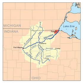
Map of the Maumee River watershed showing the
Blanchard River.
261:
favorite, while sitting on the banks of the
Blanchard River.
227:
The river is named for Jean
Jacques Blanchard (1720–1802), a
157:. Much of the length of the river can be navigated by canoe.
172:, where it turns sharply to the west. It flows west through
513:"Local Delegation Meeting With Leaders In Washington D.C."
119:
111:
101:
85:
75:
58:
50:
41:
21:
257:", a popular song of the early 20th Century and a
141:is a 103-mile-long (166 km) tributary of the
180:. It joins the Auglaize from the east in western
297:, the Blanchard River has also been known as:
281:also caused damage in Findlay in March 2011.
8:
184:approximately 2 miles (3 km) north of
356:
64:~ 5 mi (8.0 km) northwest of
362:
360:
18:
264:Around 1939 numerous projects by the
7:
295:Geographic Names Information System
272:plant to reduce ongoing pollution.
123:771 sq mi (2,000 km)
14:
479:. Bluffton, Ohio. 5 January 1939
447:"Hancock County activity varied"
445:Nofziger, Fred (June 27, 1980).
27:
164:, on the northern outskirts of
542:Rivers of Hancock County, Ohio
1:
547:Rivers of Putnam County, Ohio
417:"Blanchard River Water Trail"
266:Works Progress Administration
242:, an American outpost in the
42:Physical characteristics
103: • elevation
255:Down by the Old Mill Stream
87: • location
60: • location
568:
238:along the river in 1769.
115:103 mi (166 km)
71:
46:
26:
552:Tributaries of Lake Erie
379:"Map of Ohio watersheds"
107:686 ft (209 m)
406:, accessed May 19, 2011
207:41.041483°N 84.299245°W
33:The Blanchard River in
345:List of rivers of Ohio
234:who settled among the
134:
212:41.041483; -84.299245
132:
160:It rises in central
203: /
402:2012-03-29 at the
328:Sha-po-qua-te-sepi
325:Sha-po-qua-te-sepe
135:
477:The Bluffton news
293:According to the
127:
126:
559:
521:
520:
509:
503:
502:
495:
489:
488:
486:
484:
469:
463:
462:
460:
458:
442:
436:
435:
433:
431:
421:
413:
407:
397:The National Map
393:
387:
386:
381:. Archived from
375:
369:
364:
316:Blanchard's Fork
270:sewage treatment
218:
217:
215:
214:
213:
208:
204:
201:
200:
199:
196:
145:in northwestern
61:
31:
19:
567:
566:
562:
561:
560:
558:
557:
556:
527:
526:
525:
524:
511:
510:
506:
497:
496:
492:
482:
480:
471:
470:
466:
456:
454:
444:
443:
439:
429:
427:
419:
415:
414:
410:
404:Wayback Machine
394:
390:
377:
376:
372:
365:
358:
353:
341:
319:Blanchards Fork
291:
278:
225:
211:
209:
205:
202:
197:
194:
192:
190:
189:
139:Blanchard River
104:
88:
59:
37:
22:Blanchard River
17:
12:
11:
5:
565:
563:
555:
554:
549:
544:
539:
537:Rivers of Ohio
529:
528:
523:
522:
519:on 2013-02-09.
515:Archived from
504:
490:
464:
437:
408:
388:
385:on 2007-03-11.
370:
355:
354:
352:
349:
348:
347:
340:
337:
336:
335:
332:
331:Tailor's River
329:
326:
323:
320:
317:
314:
313:Blanchard Fork
311:
305:
290:
287:
277:
274:
224:
221:
170:Hancock County
143:Auglaize River
125:
124:
121:
117:
116:
113:
109:
108:
105:
102:
99:
98:
92:Auglaize River
89:
86:
83:
82:
79:
73:
72:
69:
68:
62:
56:
55:
52:
48:
47:
44:
43:
39:
38:
32:
24:
23:
15:
13:
10:
9:
6:
4:
3:
2:
564:
553:
550:
548:
545:
543:
540:
538:
535:
534:
532:
518:
514:
508:
505:
500:
494:
491:
478:
474:
468:
465:
452:
448:
441:
438:
425:
418:
412:
409:
405:
401:
398:
392:
389:
384:
380:
374:
371:
368:
363:
361:
357:
350:
346:
343:
342:
338:
334:Tailors River
333:
330:
327:
324:
321:
318:
315:
312:
309:
306:
303:
302:Quegh-tua-wa,
300:
299:
298:
296:
289:Variant names
288:
286:
282:
275:
273:
271:
267:
262:
260:
256:
252:
247:
245:
241:
237:
233:
230:
222:
220:
216:
187:
183:
182:Putnam County
179:
175:
171:
167:
163:
162:Hardin County
158:
156:
152:
151:United States
148:
144:
140:
131:
122:
118:
114:
110:
106:
100:
97:
93:
90:
84:
80:
78:
74:
70:
67:
63:
57:
53:
49:
45:
40:
36:
30:
25:
20:
517:the original
507:
493:
481:. Retrieved
476:
467:
455:. Retrieved
451:Toledo Blade
450:
440:
428:. Retrieved
423:
411:
391:
383:the original
373:
307:
301:
292:
283:
279:
263:
248:
240:Fort Findlay
226:
159:
138:
136:
453:. p. 7
424:ohiodnr.gov
322:Quegh-tu-wa
251:Tell Taylor
244:War of 1812
210: /
531:Categories
457:15 October
430:24 January
351:References
308:Queghtuwa,
259:barbershop
198:84°17′57″W
195:41°02′29″N
186:Cloverdale
120:Basin size
483:28 August
249:In 1908,
176:and past
155:Lake Erie
400:Archived
339:See also
310:in Odawa
304:in Odawa
276:Flooding
253:wrote "
236:Shawnee
223:History
174:Findlay
149:in the
35:Findlay
426:. ODNR
232:tailor
229:French
178:Ottawa
166:Kenton
112:Length
96:Dupont
81:
66:Kenton
54:
51:Source
420:(PDF)
94:near
77:Mouth
16:River
485:2022
459:2015
432:2024
147:Ohio
137:The
188:at
533::
475:.
449:.
422:.
359:^
219:.
501:.
487:.
461:.
434:.
Text is available under the Creative Commons Attribution-ShareAlike License. Additional terms may apply.