47:
31:
54:
527:
546:
300:
The original dam structure is L-shaped. There is the usual perpendicular crossing creating the low head spillway. However the majority of the structure is a long forebay for the canal, parallel to the left bank. The forebay has two spillways and ends with the structure of Lock 60. Lock 60 is the
603:
578:
588:
583:
46:
338:
was added to the dam on the
Chester County side. During construction, remnants of the Chester County Canal feeder lock were uncovered and documented by an archeologist.
101:
327:
In the later 20th century, the perpendicular section was extended across the end of the forebay, creating a straight bank to bank dam and capping the forebay.
346:
220:
399:
369:
309:
addition to the
Navigation, which provided water power and later transport to Phoenixville. In 1869 this canal was ruined by a flood.
608:
85:
573:
270:
448:
81:
422:
469:
286:
598:
317:
290:
320:
to power a local trolley. The generators have been removed, but the dam is still owned by power company,
374:
278:
224:
492:
306:
305:
portion of the
Navigation. In 1828 a lock was added to the right side of the dam as part of the
549:
521:
395:
282:
389:
504:
302:
274:
262:
159:
593:
194:
30:
240:
567:
331:
313:
497:
294:
258:
89:
335:
116:
103:
426:
273:, the dam was one of dozens built to create a slack water pools for the
321:
281:
of the "Schuylkill
Navigation Canal, Oakes Reach Section" registered
144:
604:
National
Register of Historic Places in Chester County, Pennsylvania
239:
Schuylkill
Navigation Canal, Oakes Reach Section Historic District (
526:
364:
545:
501:
35:
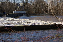
Black Rock Dam with flood waters. Canal forebay in foreground.
266:
579:
Buildings and structures in
Montgomery County, Pennsylvania
589:
53:
584:
Buildings and structures in
Chester County, Pennsylvania
330:
In 2008, as part of a project to restore the migratory
235:
193:
188:
180:
175:
165:
155:
150:
140:
132:
95:
77:
69:
23:
449:"Exelon - Black Rock Dam Construction Photographs"
18:Dam in Chester / Montgomery counties, Pennsylvania
265:. Originally constructed as a stone filled,
8:
316:generators were added to the forebay by the
498:
61:Location of Black Rock Dam in Pennsylvania
29:
20:
470:"Exelon - Black Rock Dam and its history"
347:List of crossings of the Schuylkill River
388:Catalano, Laura; Kurt D. Zwikl (2009).
356:
365:"National Register Information System"
7:
370:National Register of Historic Places
394:. Arcadia Publishing. p. 60.
14:
269:in the early 19th century by the
544:
525:
493:Exelon's Black Rock Dam Web Site
423:"Schuylkill River American Shad"
52:
45:
285:. The dam is located between
171:900 feet (270 m) fore bay
1:
513:
271:Schuylkill Navigation Company
275:Schuylkill Navigation System
542:Rail bridge at Phoenixville
625:
391:Along the Schuylkill River
169:480 feet (150 m) main
537:
531:
516:
511:
247:
231:
218:
211:
207:
203:
40:
28:
318:Reading Traction Company
609:Dams with fish ladders
221:U.S. Historic district
375:National Park Service
334:to the Schuylkill, a
279:contributing property
225:Contributing property
117:40.14778°N 75.50611°W
574:Dams in Pennsylvania
307:Chester County Canal
377:. January 23, 2007.
122:40.14778; -75.50611
113: /
301:guard lock of the
277:. The dam is a
561:
560:
556:
555:
550:Mont Clare Bridge
522:Black Rock Bridge
503:Crossings of the
401:978-0-7385-6548-4
283:historic district
251:
250:
151:Dam and spillways
133:Opening date
616:
599:Schuylkill River
548:
529:
514:
505:Schuylkill River
499:
481:
480:
478:
476:
466:
460:
459:
457:
455:
445:
439:
438:
436:
434:
429:on July 23, 2008
425:. Archived from
419:
413:
412:
410:
408:
385:
379:
378:
361:
293:in southeastern
263:Schuylkill River
160:Schuylkill River
128:
127:
125:
124:
123:
118:
114:
111:
110:
109:
106:
56:
55:
49:
33:
21:
624:
623:
619:
618:
617:
615:
614:
613:
564:
563:
562:
557:
552:
543:
541:
535:
524:
520:
507:
489:
484:
474:
472:
468:
467:
463:
453:
451:
447:
446:
442:
432:
430:
421:
420:
416:
406:
404:
402:
387:
386:
382:
363:
362:
358:
354:
344:
267:timber crib dam
227:
223:
214:
184:Black Rock Pool
170:
121:
119:
115:
112:
107:
104:
102:
100:
99:
65:
64:
63:
62:
59:
58:
57:
36:
19:
12:
11:
5:
622:
620:
612:
611:
606:
601:
596:
591:
586:
581:
576:
566:
565:
559:
558:
554:
553:
536:
533:Black Rock Dam
530:
512:
509:
508:
502:
496:
495:
488:
487:External links
485:
483:
482:
461:
440:
414:
400:
380:
355:
353:
350:
343:
340:
312:In 1902 three
255:Black Rock Dam
249:
248:
245:
244:
237:
233:
232:
229:
228:
219:
216:
215:
213:Black Rock Dam
212:
209:
208:
205:
204:
201:
200:
197:
195:Hydraulic head
191:
190:
186:
185:
182:
178:
177:
173:
172:
167:
163:
162:
157:
153:
152:
148:
147:
142:
138:
137:
134:
130:
129:
97:
93:
92:
79:
75:
74:
71:
67:
66:
60:
51:
50:
44:
43:
42:
41:
38:
37:
34:
26:
25:
24:Black Rock Dam
17:
13:
10:
9:
6:
4:
3:
2:
621:
610:
607:
605:
602:
600:
597:
595:
592:
590:
587:
585:
582:
580:
577:
575:
572:
571:
569:
551:
547:
540:
534:
528:
523:
519:
515:
510:
506:
500:
494:
491:
490:
486:
471:
465:
462:
450:
444:
441:
428:
424:
418:
415:
403:
397:
393:
392:
384:
381:
376:
372:
371:
366:
360:
357:
351:
349:
348:
341:
339:
337:
333:
332:American shad
328:
325:
323:
319:
315:
314:hydroelectric
310:
308:
304:
298:
296:
292:
288:
284:
280:
276:
272:
268:
264:
260:
256:
246:
242:
238:
234:
230:
226:
222:
217:
210:
206:
202:
198:
196:
192:
189:Power Station
187:
183:
179:
174:
168:
164:
161:
158:
154:
149:
146:
143:
139:
135:
131:
126:
98:
94:
91:
87:
83:
80:
76:
73:United States
72:
68:
48:
39:
32:
27:
22:
16:
538:
532:
517:
475:December 31,
473:. Retrieved
464:
454:November 16,
452:. Retrieved
443:
431:. Retrieved
427:the original
417:
407:November 16,
405:. Retrieved
390:
383:
368:
359:
345:
329:
326:
311:
299:
295:Pennsylvania
287:Phoenixville
259:low head dam
254:
252:
90:Pennsylvania
15:
433:October 11,
336:fish ladder
303:Oakes Canal
120: /
96:Coordinates
568:Categories
539:Downstream
352:References
291:Mont Clare
241:ID88000462
108:75°30′22″W
105:40°08′52″N
88:counties,
86:Montgomery
176:Reservoir
518:Upstream
342:See also
156:Impounds
141:Owner(s)
78:Location
297:, USA.
261:in the
236:Part of
181:Creates
136:c. 1825
82:Chester
70:Country
594:Exelon
398:
322:Exelon
166:Length
145:Exelon
257:is a
477:2009
456:2009
435:2008
409:2009
396:ISBN
289:and
253:The
199:low
570::
373:.
367:.
324:.
84:/
479:.
458:.
437:.
411:.
243:)
Text is available under the Creative Commons Attribution-ShareAlike License. Additional terms may apply.