141:
181:
148:
174:
479:
412:
352:
29:
695:
712:
687:
667:
404:. Geological events occurring many years ago created the diverse topography and drastic elevation changes over the Cascade Range leading to the various climate differences. These climate differences lead to vegetation variety defining the
458:
period dating back over two million years ago, glaciation advancing and retreating repeatedly scoured the landscape leaving deposits of rock debris. The U-shaped cross section of the river valleys is a result of recent glaciation.
387:
danger. During winter months, weather is usually cloudy, but due to high pressure systems over the
Pacific Ocean that intensify during summer months, there is often little or no cloud cover during the summer.
379:
onto the
Cascades. As a result, the west side of the North Cascades experiences high precipitation, especially during the winter months in the form of snowfall. Because of
762:
623:
140:
96:
173:
757:
304:
777:
467:
in combination with glaciation have been the dominant processes which have created the tall peaks and deep valleys of the North
Cascades area.
616:
497:
492:
254:
717:
609:
89:
672:
316:
308:
228:
660:
653:
343:
is significant as the summit rises over 3,000 feet (910 meters) above
Granite Creek in one mile (1.6 km).
767:
724:
440:
300:
218:
772:
648:
328:
67:
57:
34:
79:
573:
Beckey, Fred W. Cascade Alpine Guide, Climbing and High Routes. Seattle, WA: Mountaineers Books, 2008.
424:
436:
419:
The history of the formation of the
Cascade Mountains dates back millions of years ago to the late
340:
364:
484:
464:
411:
380:
372:
249:
351:
701:
643:
448:
401:
368:
332:
320:
242:
235:
28:
751:
601:
428:
397:
360:
292:
679:
336:
324:
269:
72:
734:
729:
524:
455:
327:, 1.06 mi (1.71 km) to the west. Blackbeard Peak can be seen from the
474:
312:
296:
276:
111:
98:
405:
384:
376:
460:
444:
432:
396:
The North
Cascades features some of the most rugged topography in the
547:
420:
47:
335:
from
Blackbeard Peak drains into Granite Creek, a tributary of the
410:
350:
605:
375:), causing them to drop their moisture in the form of rain or
363:
originating in the
Pacific Ocean travel northeast toward the
371:, they are forced upward by the peaks of the Cascade Range (
569:
567:
383:, snow tends to be wet and heavy, resulting in high
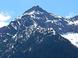
291:, is a 7,241-foot (2,207 m) mountain summit in the
268:
263:
248:
234:
224:
214:
206:
127:
88:
78:
66:
56:
46:
41:
21:
435:persisted. In addition, small fragments of the
33:Blackbeard Peak seen from the northeast on the
617:
542:
540:
538:
16:Mountain in Washington (state), United States
8:
585:
583:
581:
579:
624:
610:
602:
592:The Natural History of Puget Sound Country
18:
160:Location of Blackbeard Peak in Washington
509:
180:
147:
763:Mountains of Skagit County, Washington
400:with craggy peaks and ridges and deep
7:
639:
519:
517:
515:
513:
193:Blackbeard Peak (the United States)
632:Places adjacent to Blackbeard Peak
305:Okanogan–Wenatchee National Forest
14:
594:. University of Washington Press.
323:. Its nearest higher neighbor is
710:
693:
685:
665:
498:Geology of the Pacific Northwest
477:
179:
172:
146:
139:
27:
758:Mountains of Washington (state)
493:Geography of the North Cascades
548:"Black Beard Peak - 7,241' WA"
355:Blackbeard Peak from northeast
311:. It is situated northwest of
163:Show map of Washington (state)
1:
778:North American 2000 m summits
711:
666:
525:"Blackbeard Peak, Washington"
415:Blackbeard seen from the east
196:Show map of the United States
694:
686:
451:about 50 million years ago.
52:7,241 ft (2,207 m)
590:Kruckeberg, Arthur (1991).
84:1.51 mi (2.43 km)
794:
637:
433:volcanic igneous activity
367:. As fronts approach the
132:
26:
62:361 ft (110 m)
441:continental lithosphere
303:. It is located in the
649:North Cascades Highway
416:
356:
329:North Cascades Highway
112:48.53583°N 120.78556°W
35:North Cascades Highway
414:
354:
425:North American Plate
117:48.53583; -120.78556
319:, and southeast of
108: /
417:
381:maritime influence
357:
341:Topographic relief
42:Highest point
745:
744:
740:
739:
718:Whistler Mountain
365:Cascade Mountains
282:
281:
785:
714:
713:
697:
696:
689:
688:
669:
668:
640:
626:
619:
612:
603:
596:
595:
587:
574:
571:
562:
561:
559:
558:
544:
533:
532:
521:
487:
485:Mountains portal
482:
481:
480:
423:Epoch. With the
331:. Precipitation
289:Black Beard Peak
272:
238:
197:
183:
182:
176:
164:
150:
149:
143:
123:
122:
120:
119:
118:
113:
109:
106:
105:
104:
101:
31:
19:
793:
792:
788:
787:
786:
784:
783:
782:
748:
747:
746:
741:
698:
691:Blackbeard Peak
633:
630:
600:
599:
589:
588:
577:
572:
565:
556:
554:
552:listsofjohn.com
546:
545:
536:
523:
522:
511:
506:
483:
478:
476:
473:
427:overriding the
402:glacial valleys
394:
373:orographic lift
349:
315:, southwest of
287:, also spelled
285:Blackbeard Peak
270:
236:
202:
201:
200:
199:
198:
195:
194:
191:
190:
189:
188:
187:Blackbeard Peak
184:
167:
166:
165:
162:
161:
158:
157:
156:
155:
154:Blackbeard Peak
151:
116:
114:
110:
107:
102:
99:
97:
95:
94:
37:
22:Blackbeard Peak
17:
12:
11:
5:
791:
789:
781:
780:
775:
770:
768:North Cascades
765:
760:
750:
749:
743:
742:
738:
737:
732:
727:
721:
720:
715:
708:
705:
704:
702:Cutthroat Peak
699:
684:
682:
676:
675:
673:Porcupine Peak
670:
663:
657:
656:
651:
646:
644:Graybeard Peak
638:
635:
634:
631:
629:
628:
621:
614:
606:
598:
597:
575:
563:
534:
529:Peakbagger.com
508:
507:
505:
502:
501:
500:
495:
489:
488:
472:
469:
449:North Cascades
431:, episodes of
408:in this area.
393:
390:
369:North Cascades
361:weather fronts
348:
345:
321:Graybeard Peak
317:Porcupine Peak
293:North Cascades
280:
279:
274:
266:
265:
261:
260:
252:
246:
245:
243:North Cascades
240:
232:
231:
226:
222:
221:
216:
212:
211:
208:
204:
203:
192:
186:
185:
178:
177:
171:
170:
169:
168:
159:
153:
152:
145:
144:
138:
137:
136:
135:
134:
133:
130:
129:
125:
124:
92:
86:
85:
82:
76:
75:
70:
64:
63:
60:
54:
53:
50:
44:
43:
39:
38:
32:
24:
23:
15:
13:
10:
9:
6:
4:
3:
2:
790:
779:
776:
774:
773:Cascade Range
771:
769:
766:
764:
761:
759:
756:
755:
753:
736:
733:
731:
728:
726:
723:
722:
719:
716:
709:
707:
706:
703:
700:
692:
683:
681:
678:
677:
674:
671:
664:
662:
659:
658:
655:
652:
650:
647:
645:
642:
641:
636:
627:
622:
620:
615:
613:
608:
607:
604:
593:
586:
584:
582:
580:
576:
570:
568:
564:
553:
549:
543:
541:
539:
535:
530:
526:
520:
518:
516:
514:
510:
503:
499:
496:
494:
491:
490:
486:
475:
470:
468:
466:
462:
457:
452:
450:
446:
442:
438:
434:
430:
429:Pacific Plate
426:
422:
413:
409:
407:
403:
399:
398:Cascade Range
391:
389:
386:
382:
378:
374:
370:
366:
362:
353:
346:
344:
342:
338:
334:
330:
326:
322:
318:
314:
310:
309:Skagit County
306:
302:
298:
294:
290:
286:
278:
275:
273:
271:Easiest route
267:
262:
259:
256:
253:
251:
247:
244:
241:
239:
233:
230:
227:
223:
220:
217:
213:
210:United States
209:
205:
175:
142:
131:
126:
121:
93:
91:
87:
83:
81:
77:
74:
71:
69:
65:
61:
59:
55:
51:
49:
45:
40:
36:
30:
25:
20:
690:
680:Repulse Peak
591:
555:. Retrieved
551:
528:
453:
447:created the
418:
395:
358:
337:Skagit River
325:Repulse Peak
288:
284:
283:
258:Mount Arriva
257:
237:Parent range
73:Repulse Peak
735:Crooked Bum
730:Corteo Peak
661:Fisher Peak
654:Mount Hardy
456:Pleistocene
454:During the
115: /
103:120°47′08″W
90:Coordinates
68:Parent peak
752:Categories
725:Black Peak
557:2021-04-24
504:References
406:ecoregions
313:Rainy Pass
301:Washington
297:U.S. state
277:Scrambling
219:Washington
100:48°32′09″N
58:Prominence
385:avalanche
128:Geography
80:Isolation
48:Elevation
471:See also
465:faulting
445:terranes
377:snowfall
264:Climbing
250:Topo map
443:called
437:oceanic
392:Geology
347:Climate
295:in the
207:Country
461:Uplift
421:Eocene
333:runoff
229:Skagit
225:County
359:Most
215:State
463:and
439:and
255:USGS
307:in
299:of
754::
578:^
566:^
550:.
537:^
527:.
512:^
339:.
625:e
618:t
611:v
560:.
531:.
Text is available under the Creative Commons Attribution-ShareAlike License. Additional terms may apply.