180:. The trail winds down to the oceanfront overlooking Gabriola Island through a coastal Douglas Fir forest, which leads down Joan Point Park, a 23-acre waterfront park which provides a vantage point overlooking Dodds Narrows. Dodds Narrows is a narrow tidal passage separating Vancouver Island from Mudge Island, which flows in opposing directions based on tidal flows. The narrows is a hot spot for marine activity and a popular marine passage between Nanaimo and the Southern Gulf Islands. Passage through Dodds Narrows is described in detail in Margaret Sharcott's 1957 book, Troller's Holiday.
206:
194:
61:
290:
E., Catherall, Erin; K., Janes, Jasmine; A., Josefsson, Caroline; C., Gorrell, Jamieson (2018). " Spatial and temporal assessments of genetic structure in an endangered Garry oak ecosystem on
Vancouver Island".
322:
364:
193:
205:
230:
154:
21:
173:, British Columbia, Canada. The trail has been ranked among the top ten forest walks in the Vancouver Island Region.
374:
349:
177:
82:
316:
255:
Pagh, Nancy (1999). "An
Indescribable Sea: Discourse of Women Traveling the Northwest Coast by Boat".
184:
272:
339:
344:
304:
143:
369:
296:
264:
170:
60:
358:
147:
308:
36:
23:
89:
276:
187:, and features in genetic studies of endangered Garry Oak populations.
300:
268:
231:"Cathedral Grove Ranked Top Forest Walk In Vancouver Island Region"
340:
City of
Nanaimo Parks Information for the Cable Bay Trail
350:
Seaside trail offers forests and ferns, Times
Colonist
159:
Moderately steep section of trail and slippery rocks
199:
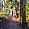
The Cable Bay Trail leading down through the forest
153:
138:
130:
122:
114:
106:
98:
88:
78:
70:
53:
345:Trail Peak Information on the Cable Bay Trail
8:
321:: CS1 maint: multiple names: authors list (
176:The trail is accessed via Nicola Road in
16:Hiking trail in British Columbia, Canada
222:
189:
169:is a 2 km hiking trail located on
314:
50:
257:Frontiers: A Journal of Women Studies
7:
211:The trail leading through the woods
14:
365:Hiking trails in British Columbia
204:
192:
59:
183:The trail also passes through
65:Trail through the upper forest
1:
391:
58:
83:Cedar, British Columbia
74:2 km (1.2 mi)
185:Garry Oak ecosystems
37:49.1264°N 123.8277°W
107:Elevation gain/loss
33: /
42:49.1264; -123.8277
163:
162:
144:old growth forest
382:
375:Vancouver Island
327:
326:
320:
312:
287:
281:
280:
252:
246:
245:
243:
242:
227:
208:
196:
171:Vancouver Island
63:
51:
48:
47:
45:
44:
43:
38:
34:
31:
30:
29:
26:
390:
389:
385:
384:
383:
381:
380:
379:
355:
354:
336:
331:
330:
313:
301:10.25316/ir-409
289:
288:
284:
269:10.2307/3347216
254:
253:
249:
240:
238:
235:HuffPost Canada
229:
228:
224:
219:
212:
209:
200:
197:
167:Cable Bay Trail
66:
54:Cable Bay Trail
41:
39:
35:
32:
27:
24:
22:
20:
19:
17:
12:
11:
5:
388:
386:
378:
377:
372:
367:
357:
356:
353:
352:
347:
342:
335:
334:External links
332:
329:
328:
282:
247:
221:
220:
218:
215:
214:
213:
210:
203:
201:
198:
191:
161:
160:
157:
151:
150:
148:marine mammals
140:
136:
135:
132:
128:
127:
124:
120:
119:
116:
112:
111:
108:
104:
103:
100:
96:
95:
92:
86:
85:
80:
76:
75:
72:
68:
67:
64:
56:
55:
15:
13:
10:
9:
6:
4:
3:
2:
387:
376:
373:
371:
368:
366:
363:
362:
360:
351:
348:
346:
343:
341:
338:
337:
333:
324:
318:
310:
306:
302:
298:
294:
286:
283:
278:
274:
270:
266:
262:
258:
251:
248:
236:
232:
226:
223:
216:
207:
202:
195:
190:
188:
186:
181:
179:
174:
172:
168:
158:
156:
152:
149:
145:
141:
137:
133:
129:
125:
121:
117:
115:Highest point
113:
109:
105:
101:
97:
93:
91:
87:
84:
81:
77:
73:
69:
62:
57:
52:
49:
46:
317:cite journal
292:
285:
260:
256:
250:
239:. Retrieved
237:. 2013-09-03
234:
225:
182:
175:
166:
164:
146:, birds and
123:Lowest point
18:
263:(3): 1–26.
94:Nicola Road
40: /
28:123°49′40″W
359:Categories
241:2018-11-16
217:References
131:Difficulty
90:Trailheads
25:49°07′35″N
309:1916-2790
293:Botanique
142:Beaches,
79:Location
370:Nanaimo
277:3347216
155:Hazards
307:
275:
139:Sights
102:Hiking
71:Length
273:JSTOR
178:Cedar
323:link
305:ISSN
165:The
134:Easy
297:doi
265:doi
118:90m
110:90m
99:Use
361::
319:}}
315:{{
303:.
295:.
271:.
261:20
259:.
233:.
126:0m
325:)
311:.
299::
279:.
267::
244:.
Text is available under the Creative Commons Attribution-ShareAlike License. Additional terms may apply.