557:
38:
597:
650:
242:
into the Rio
Yungane. It does so by crossing the mountains through the Huaylillas Norte tunnel. The Rio Yungane subsequently joins the Quebrada Vilavilani. The Quebrada Vilavilani descends the Andes in southwestward direction, where it has several different names, and ends close to the city of
213:
at 4,460 metres (14,630 ft) elevation. The path of the canal takes it southeastward through
Peruvian territory until the Peru-Chile border at Laguna Blanca. It continues through Chilean territory from Laguna Blanca along the
454:
711:
447:
440:
746:
741:
634:
687:
234:, crosses the Rio Azufre westward and then the border between Chile and Peru. In Peru it continues southwestward and ends between the mountains of
350:
259:
This canal was constructed in 1820. There were numerous projects to expand the canal system to more water sources in the Mauri, and the
556:
263:
was constructed in 1954. According to a report in 1977, the Canal
Uchusuma is still used when the other canal is under maintenance.
141:
101:
627:
409:
706:
680:
726:
134:
94:
736:
287:
721:
620:
673:
467:
215:
716:
293:
731:
541:
198:
297:
239:
511:
235:
521:
516:
506:
546:
223:
358:
230:. It turns around Tacora's southern flank to its western side while following a low-altitude
571:
432:
37:
576:
496:
481:
657:
604:
501:
202:
78:
700:
248:
531:
526:
491:
486:
463:
413:
260:
227:
206:
20:
332:
330:
328:
326:
156:
143:
116:
103:
596:
649:
231:
219:
244:
186:
182:
55:
51:
436:
391:
379:
336:
317:
42:
Map of the general region, with the canal shown in the centre
656:
This article about a
Peruvian building or structure is a
603:
This article about a
Chilean building or structure is a
661:
608:
712:
Buildings and structures in Arica y
Parinacota Region
564:
474:
172:
132:
92:
84:
74:
66:
61:
47:
30:
414:"Actualización hidrológica del Proyecto Maure"
681:
628:
448:
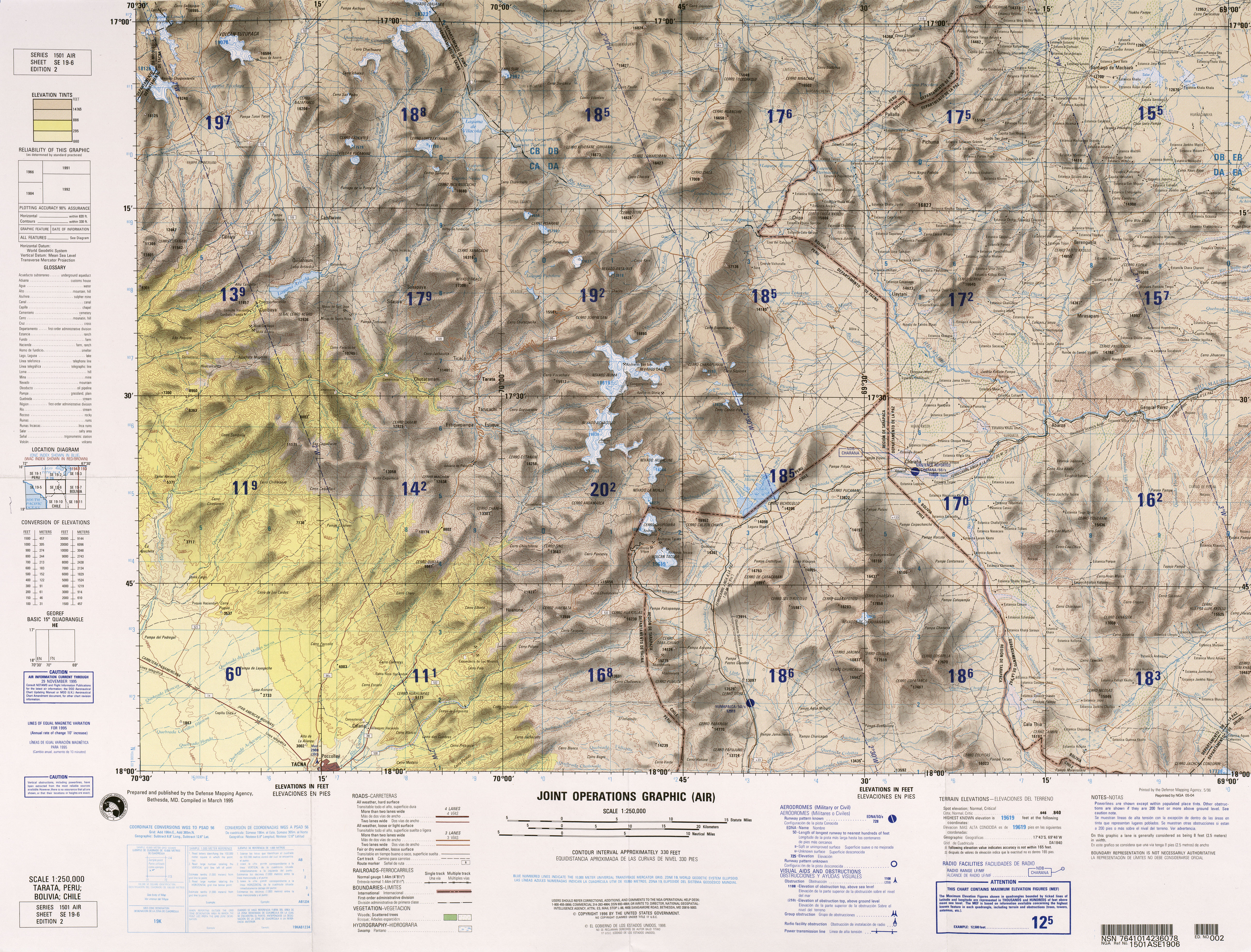
197:The canal begins at the northeastern foot of
8:
688:
674:
635:
621:
455:
441:
433:
27:
419:(in Spanish). Autoridad Nacional del Agua
272:
209:; the diversion occurs at the locality
747:Peruvian building and structure stubs
282:
280:
278:
276:
7:
742:Chilean building and structure stubs
646:
644:
593:
591:
392:Ministry of Agriculture of Peru 1977
380:Ministry of Agriculture of Peru 1977
337:Ministry of Agriculture of Peru 1977
318:Ministry of Agriculture of Peru 1977
218:southwestward between the mountains
14:
648:
595:
555:
36:
410:Ministry of Agriculture of Peru
205:, a principal tributary of the
292:(Map) (2 ed.). 1:250000.
1:
660:. You can help Knowledge by
607:. You can help Knowledge by
289:Tarata, Peru; Bolivia; Chile
763:
643:
590:
18:
553:
468:Arica y Parinacota Region
349:Oregon State University.
35:
294:Joint Operations Graphic
19:Not to be confused with
298:Defense Mapping Agency
157:17.76778°S 69.84250°W
117:17.56667°S 69.73000°W
216:Arica–La Paz railway
162:-17.76778; -69.84250
122:-17.56667; -69.73000
727:Irrigation in Chile
153: /
113: /
737:Irrigation in Peru
722:Irrigation canals
707:Chile–Peru border
669:
668:
616:
615:
585:
584:
240:Cerro Chulluncane
176:
175:
754:
690:
683:
676:
652:
645:
637:
630:
623:
599:
592:
559:
457:
450:
443:
434:
428:
426:
424:
418:
395:
389:
383:
377:
371:
370:
368:
366:
361:on 12 April 2018
357:. Archived from
346:
340:
334:
321:
315:
309:
308:
306:
304:
284:
236:Cerro Huaylillas
168:
167:
165:
164:
163:
158:
154:
151:
150:
149:
146:
128:
127:
125:
124:
123:
118:
114:
111:
110:
109:
106:
40:
28:
762:
761:
757:
756:
755:
753:
752:
751:
717:Canals in Chile
697:
696:
695:
694:
642:
641:
588:
586:
581:
577:Cotacotani Lake
560:
551:
470:
461:
431:
422:
420:
416:
412:(August 1977).
408:
404:
399:
398:
390:
386:
378:
374:
364:
362:
348:
347:
343:
335:
324:
316:
312:
302:
300:
286:
285:
274:
269:
257:
226:, close to the
195:
161:
159:
155:
152:
147:
144:
142:
140:
139:
121:
119:
115:
112:
107:
104:
102:
100:
99:
43:
24:
17:
12:
11:
5:
760:
758:
750:
749:
744:
739:
734:
732:Canals in Peru
729:
724:
719:
714:
709:
699:
698:
693:
692:
685:
678:
670:
667:
666:
653:
640:
639:
632:
625:
617:
614:
613:
600:
583:
582:
580:
579:
574:
568:
566:
562:
561:
554:
552:
550:
549:
544:
539:
537:Canal Uchusuma
534:
529:
524:
519:
514:
509:
504:
499:
494:
489:
484:
478:
476:
472:
471:
462:
460:
459:
452:
445:
437:
430:
429:
405:
403:
400:
397:
396:
384:
372:
341:
322:
310:
271:
270:
268:
265:
256:
253:
211:Ancochaullanta
203:Uchusuma River
199:Cerro Huancune
194:
191:
179:Canal Uchusuma
174:
173:
170:
169:
137:
130:
129:
97:
90:
89:
86:
82:
81:
79:Uchusuma River
76:
72:
71:
68:
64:
63:
59:
58:
49:
45:
44:
41:
33:
32:
31:Canal Uchusuma
15:
13:
10:
9:
6:
4:
3:
2:
759:
748:
745:
743:
740:
738:
735:
733:
730:
728:
725:
723:
720:
718:
715:
713:
710:
708:
705:
704:
702:
691:
686:
684:
679:
677:
672:
671:
665:
663:
659:
654:
651:
647:
638:
633:
631:
626:
624:
619:
618:
612:
610:
606:
601:
598:
594:
589:
578:
575:
573:
572:Chungará Lake
570:
569:
567:
563:
558:
548:
545:
543:
540:
538:
535:
533:
530:
528:
525:
523:
520:
518:
515:
513:
510:
508:
505:
503:
500:
498:
495:
493:
490:
488:
485:
483:
480:
479:
477:
473:
469:
465:
458:
453:
451:
446:
444:
439:
438:
435:
415:
411:
407:
406:
401:
394:, p. 14.
393:
388:
385:
381:
376:
373:
360:
356:
355:Volcano World
352:
345:
342:
339:, p. 13.
338:
333:
331:
329:
327:
323:
319:
314:
311:
299:
295:
291:
290:
283:
281:
279:
277:
273:
266:
264:
262:
254:
252:
250:
249:Caplina River
246:
241:
237:
233:
229:
225:
221:
217:
212:
208:
204:
200:
192:
190:
188:
184:
180:
171:
166:
138:
136:
131:
126:
98:
96:
91:
87:
83:
80:
77:
73:
69:
65:
60:
57:
53:
50:
46:
39:
34:
29:
26:
22:
16:Chilean canal
662:expanding it
655:
609:expanding it
602:
587:
536:
421:. Retrieved
387:
382:, p. 2.
375:
363:. Retrieved
359:the original
354:
344:
320:, p. 5.
313:
301:. Retrieved
288:
258:
210:
196:
178:
177:
25:
532:Canal Mauri
527:Canal Lauca
464:Hydrography
423:27 February
365:27 February
303:27 February
261:Canal Mauri
228:Canal Mauri
207:Mauri River
160: /
135:coordinates
120: /
95:coordinates
88:Rio Yungane
75:Start point
21:Canal Mauri
701:Categories
267:References
224:Caracarani
148:69°50′33″W
145:17°46′04″S
108:69°43′48″W
105:17°34′00″S
93:Beginning
522:Viscacham
497:Camarones
482:Cosapilla
247:into the
193:Geography
85:End point
70:Southwest
67:Direction
62:Geography
542:San José
517:Tignamar
507:Rivilcar
502:Uchusuma
351:"Tacora"
547:Atajama
402:Sources
255:History
232:moraine
201:on the
133:Ending
48:Country
475:Rivers
220:Tacora
565:Lakes
492:Lauca
487:Lluta
417:(PDF)
245:Tacna
187:Chile
183:canal
181:is a
56:Chile
658:stub
605:stub
512:Seco
425:2018
367:2018
305:2018
238:and
222:and
52:Peru
466:of
185:in
703::
353:.
325:^
296:.
275:^
251:.
189:.
54:,
689:e
682:t
675:v
664:.
636:e
629:t
622:v
611:.
456:e
449:t
442:v
427:.
369:.
307:.
23:.
Text is available under the Creative Commons Attribution-ShareAlike License. Additional terms may apply.
