27:
191:
The US Army operated the
Carrington Island Precision Bombing Range on the island during World War II. Its surface remains pockmarked with bomb craters from this era. As the island was never cleaned up due to its remote location, unexploded ordnance may still be present. SAC Bay on the island's
207:
The northwestern 542 acres of the island are privately owned by the Six Mile Ranch Co. of
Grantsville, UT. The remainder of the island is public land managed by the Bureau of Land Management. Sandbars connect the island to Stansbury Island and to the mainland but are cut by canals.
61:
188:
Charles
Stoddard filed a homestead claim on the island in 1932 and built a cabin, but left the island after his well produced only saltwater.
391:
351:
26:
301:
441:
436:
431:
326:
278:
240:
177:
Carrington Island is named for Utah pioneer and apostle of the Church of Jesus Christ of Latter-Day Saints
426:
193:
146:
382:
Miller, David E. (June 1980). "Great Salt Lake: A Historical Sketch". In Gwynn, J. Wallace (ed.).
405:
397:
387:
178:
217:
182:
222:
199:
Brine shrimp harvesters in the area operate a radio repeater on the summit of the island.
181:. Lambourne's Rock (elevation 4727 feet) at the summit of the island is named for painter
162:
49:
253:
366:
Tooele County Parcel Map, parcel numbers 04-001-0-0001 and 04-002-0-0001. Accessible at
420:
367:
124:
31:
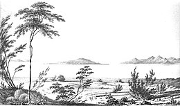
Carrington Island seen from
Stansbury Island during the Stansbury Expedition (1850)
192:
southeastern shore and SAC point on the island's southern tip were named for the
241:
U.S. Geological Survey
Geographic Names Information System: Carrington Island
76:
63:
409:
158:
279:"Great Salt Lake: a Scientific, Historical, and Economic Overview"
401:
384:
Great Salt Lake: A Scientific, Historical, and
Economic Overview
166:
136:
142:
132:
116:
108:
100:
92:
55:
45:
40:
386:. Vol. Bulletin 116. Utah Geological Survey.
368:https://erecording.tooeleco.org/eaglesoftware/web/
353:Decisions on Geographic Names in the United States
350:Names, United States Board on Geographic (1976).
302:"OLD ORDNANCE REPORTED ON MILES OF PUBLIC LANDS"
169:. It is the fourth-largest island in the lake.
8:
196:during the island's use as a bombing range.
19:
283:Utah Geological and Mineral Survey Bulletin
25:
18:
356:. Department of the Interior. p. 23.
233:
7:
327:"Old bombs, shells lurking in Utah"
14:
96:4.8 km (1.9 sq mi)
277:Gwynn, J. Wallace (June 1980).
77:41.006928833°N 112.571044000°W
1:
325:Davidson, Lee (2004-01-16).
300:Davidson, Lee (1994-10-16).
82:41.006928833; -112.571044000
458:
112:3.2 km (1.99 mi)
104:2.7 km (1.68 mi)
121:
36:
24:
254:"Great Salt Lake, Utah"
194:Strategic Air Command
442:Lake islands of Utah
73: /
21:
179:Albert Carrington
155:Carrington Island
152:
151:
20:Carrington Island
449:
413:
370:
364:
358:
357:
347:
341:
340:
338:
337:
322:
316:
315:
313:
312:
297:
291:
290:
274:
268:
267:
265:
263:
258:
249:
243:
238:
218:Stansbury Island
183:Alfred Lambourne
157:is a 1,200-acre
88:
87:
85:
84:
83:
78:
74:
71:
70:
69:
68:112°34′15.7584″W
66:
29:
22:
457:
456:
452:
451:
450:
448:
447:
446:
437:Islands of Utah
432:Great Salt Lake
417:
416:
394:
381:
378:
376:Further reading
373:
365:
361:
349:
348:
344:
335:
333:
324:
323:
319:
310:
308:
299:
298:
294:
276:
275:
271:
261:
259:
256:
251:
250:
246:
239:
235:
231:
223:Gunnison Island
214:
205:
175:
163:Great Salt Lake
161:located in the
128:
81:
79:
75:
72:
67:
64:
62:
60:
59:
50:Great Salt Lake
32:
17:
12:
11:
5:
455:
453:
445:
444:
439:
434:
429:
419:
418:
415:
414:
392:
377:
374:
372:
371:
359:
342:
317:
292:
269:
244:
232:
230:
227:
226:
225:
220:
213:
210:
204:
201:
174:
171:
150:
149:
144:
140:
139:
134:
130:
129:
122:
119:
118:
117:Administration
114:
113:
110:
106:
105:
102:
98:
97:
94:
90:
89:
65:41°0′24.9438″N
57:
53:
52:
47:
43:
42:
38:
37:
34:
33:
30:
16:Island in Utah
15:
13:
10:
9:
6:
4:
3:
2:
454:
443:
440:
438:
435:
433:
430:
428:
425:
424:
422:
411:
407:
403:
399:
395:
393:1-55791-083-9
389:
385:
380:
379:
375:
369:
363:
360:
355:
354:
346:
343:
332:
328:
321:
318:
307:
303:
296:
293:
288:
284:
280:
273:
270:
255:
248:
245:
242:
237:
234:
228:
224:
221:
219:
216:
215:
211:
209:
202:
200:
197:
195:
189:
186:
184:
180:
172:
170:
168:
164:
160:
156:
148:
145:
141:
138:
135:
131:
127:
126:
125:United States
120:
115:
111:
107:
103:
99:
95:
91:
86:
58:
54:
51:
48:
44:
39:
35:
28:
23:
427:Lake islands
383:
362:
352:
345:
334:. Retrieved
331:Deseret News
330:
320:
309:. Retrieved
306:Deseret News
305:
295:
286:
282:
272:
262:24 September
260:. Retrieved
247:
236:
206:
198:
190:
187:
176:
165:in northern
154:
153:
123:
80: /
56:Coordinates
421:Categories
336:2020-09-24
311:2020-09-24
229:References
41:Geography
402:80623880
212:See also
46:Location
410:6659366
173:History
408:
400:
390:
252:USGS.
203:Access
159:island
147:Tooele
143:County
101:Length
257:(PDF)
133:State
109:Width
406:OCLC
398:LCCN
388:ISBN
289:: 6.
264:2020
167:Utah
137:Utah
93:Area
287:116
423::
404:.
396:.
329:.
304:.
285:.
281:.
185:.
412:.
339:.
314:.
266:.
Text is available under the Creative Commons Attribution-ShareAlike License. Additional terms may apply.