172:
17:
136:
213:
242:
232:
206:
150:
145:
237:
155:
199:
30:
140:
114:
67:
183:
171:
226:
179:
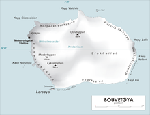
59:
45:
32:
63:
16:
15:
92:
62:. It was first charted in 1898 by a German expedition under
187:
58:)is a headland forming the southwest extremity of
207:
8:
115:"Prof. Dr. phil., Dr. med. h. c. Carl Chun"
214:
200:
74:in December 1927; they applied the name.
66:. The Norwegian expedition under Captain
83:
7:
168:
166:
243:Subantarctic island geography stubs
151:Geographic Names Information System
186:. You can help Knowledge (XXG) by
14:
170:
139: This article incorporates
134:
156:United States Geological Survey
1:
70:made a landing here from the
259:
233:Headlands of Bouvet Island
165:
117:. University of Leipzig
95:. Store norske leksikon
238:Norway geography stubs
182:location article is a
141:public domain material
21:
19:
42: /
22:
195:
194:
250:
216:
209:
202:
174:
167:
159:
138:
137:
127:
126:
124:
122:
111:
105:
104:
102:
100:
88:
68:Harald Horntvedt
57:
56:
54:
53:
52:
47:
46:54.467°S 3.367°E
43:
40:
39:
38:
35:
20:Map of Bouvetøya
258:
257:
253:
252:
251:
249:
248:
247:
223:
222:
221:
220:
163:
144:
135:
131:
130:
120:
118:
113:
112:
108:
98:
96:
90:
89:
85:
80:
50:
48:
44:
41:
36:
33:
31:
29:
28:
12:
11:
5:
256:
254:
246:
245:
240:
235:
225:
224:
219:
218:
211:
204:
196:
193:
192:
175:
161:
160:
129:
128:
106:
82:
81:
79:
76:
51:-54.467; 3.367
13:
10:
9:
6:
4:
3:
2:
255:
244:
241:
239:
236:
234:
231:
230:
228:
217:
212:
210:
205:
203:
198:
197:
191:
189:
185:
181:
180:Bouvet Island
176:
173:
169:
164:
157:
153:
152:
147:
142:
133:
132:
116:
110:
107:
94:
87:
84:
77:
75:
73:
69:
65:
61:
60:Bouvet Island
55:
26:
18:
188:expanding it
177:
162:
149:
146:"Cato Point"
119:. Retrieved
109:
97:. Retrieved
91:Susan Barr.
86:
71:
24:
23:
93:"Bouvetøya"
49: /
227:Categories
121:October 1,
99:October 1,
78:References
25:Cato Point
64:Carl Chun
72:Norvegia
34:54°28′S
37:3°22′E
178:This
143:from
184:stub
123:2016
101:2016
229::
154:.
148:.
215:e
208:t
201:v
190:.
158:.
125:.
103:.
27:(
Text is available under the Creative Commons Attribution-ShareAlike License. Additional terms may apply.
↑