29:
41:
200:), characterized as a climate in which at least one month has an average temperature high enough to melt snow (0 °C or 32 °F), but no month with an average temperature over (10 °C or 50 °F). Precipitation ranges from 400 mm/year in the northwest to 200 mm/year in the southeast.
154:
in China. Because of the high altitude—much it over 5,000 metres (16,000 ft)—the region is a cold, arid desert that is only 20% covered with steppe and meadow vegetation. The area has been relatively free from human development due to the hostile climate and unsuitability for agriculture. The
208:
Vegetation zones in the region are greatly affected by elevation and precipitation, but are generally sparsely covered. Precipitation controls which alpine zones will have meadow, steppe, or cold desert vegetation Higher steppe elevations support sedges
175:
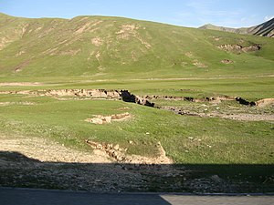
to the south. The plateau tilts gently down towards the southeast, with elevations of 6,000 meters on the
Changtang in the northwest to 3,200 meters at Qingai Lake in
106:
28:
374:
226:
and some woody forbs, but there are no trees on the plateau. Small stands of brush and trees can be found in the low, southern river valleys.
73:
341:
194:
379:
369:
146:(WWF ID: PA1002) covers the high alpine plateau that stretches over 1,600 kilometres (1,000 mi) across the
167:
plateau, a part of the greater
Qinghai-Tibet Plateau. This area is a high basin between the even higher
246:
56:
155:
ecosystem is relatively intact, and supports herds of wild antelope, sheep, deer, and gazelles.
230:
179:. The terrain is generally rolling plains. At wide intervals are shallow, brackish lakes.
147:
316:
223:
363:
151:
271:
40:
61:
121:
108:
172:
164:
143:
176:
293:
234:
189:
168:
217:
211:
68:
315:
Kottek, M.; Grieser, J.; Beck, C.; Rudolf, B.; Rubel, F. (2006).
317:"World Map of Koppen-Geiger Climate Classification Updated"
222:) increasing in lower altitudes. Wetter areas will support
163:Towards the west, the ecoregion is on the southern
100:
92:
84:
79:
67:
55:
50:
33:
Qinghai-Tibet
Plateau, in the east of the ecoregion
21:
8:
342:"Dataset - Koppen climate classifications"
237:), several species of deer, and gazelles.
88:629,626 km (243,100 sq mi)
187:The climate of most of the ecoregion is
272:"Central Tibetan Plateau alpine steppe"
258:
18:
266:
264:
262:
141:Central Tibetan Plateau alpine steppe
22:Central Tibetan Plateau alpine steppe
7:
14:
375:Montane grasslands and shrublands
274:. World Wildlife Federation (WWF)
74:Montane grasslands and shrublands
229:The area supports herds of wild
39:
27:
16:Ecoregion in the Tibetan Plateau
171:Mountains to the north and the
45:Ecoregion territory (in purple)
1:
215:), with purple feathergrass (
195:Köppen climate classification
322:. Gebrüder Borntraeger 2006
396:
296:. Resolve, using WWF data
38:
26:
294:"Map of Ecoregions 2017"
159:Location and description
233:, Chinese blue sheep (
380:Palearctic ecoregions
370:Ecoregions of China
247:Ecoregions in China
118: /
137:
136:
122:34.000°N 92.000°E
387:
354:
353:
351:
349:
338:
332:
331:
329:
327:
321:
312:
306:
305:
303:
301:
290:
284:
283:
281:
279:
268:
231:Tibetan antelope
133:
132:
130:
129:
128:
123:
119:
116:
115:
114:
111:
43:
31:
19:
395:
394:
390:
389:
388:
386:
385:
384:
360:
359:
358:
357:
347:
345:
340:
339:
335:
325:
323:
319:
314:
313:
309:
299:
297:
292:
291:
287:
277:
275:
270:
269:
260:
255:
243:
206:
204:Flora and fauna
185:
161:
148:Tibetan Plateau
126:
124:
120:
117:
112:
109:
107:
105:
104:
46:
34:
17:
12:
11:
5:
393:
391:
383:
382:
377:
372:
362:
361:
356:
355:
333:
307:
285:
257:
256:
254:
251:
250:
249:
242:
239:
224:cushion plants
205:
202:
190:Tundra climate
184:
181:
160:
157:
135:
134:
127:34.000; 92.000
102:
98:
97:
94:
90:
89:
86:
82:
81:
77:
76:
71:
65:
64:
59:
53:
52:
48:
47:
44:
36:
35:
32:
24:
23:
15:
13:
10:
9:
6:
4:
3:
2:
392:
381:
378:
376:
373:
371:
368:
367:
365:
348:September 14,
343:
337:
334:
326:September 14,
318:
311:
308:
300:September 14,
295:
289:
286:
273:
267:
265:
263:
259:
252:
248:
245:
244:
240:
238:
236:
232:
227:
225:
221:
219:
214:
213:
203:
201:
199:
196:
192:
191:
182:
180:
178:
174:
170:
166:
158:
156:
153:
149:
145:
142:
131:
103:
99:
95:
91:
87:
83:
78:
75:
72:
70:
66:
63:
60:
58:
54:
49:
42:
37:
30:
25:
20:
346:. Retrieved
344:. World Bank
336:
324:. Retrieved
310:
298:. Retrieved
288:
278:December 28,
276:. Retrieved
228:
216:
210:
207:
197:
188:
186:
162:
152:Qinghai Lake
140:
138:
125: /
101:Coordinates
364:Categories
253:References
62:Palearctic
173:Himalayas
165:Changtang
144:ecoregion
93:Countries
80:Geography
241:See also
220:purpurea
183:Climate
177:Qinghai
113:92°00′E
110:34°00′N
51:Ecology
235:Bharal
169:Kunlun
320:(PDF)
218:Stipa
212:Carex
96:China
69:Biome
57:Realm
350:2019
328:2019
302:2019
280:2019
139:The
85:Area
150:to
366::
261:^
198:ET
352:.
330:.
304:.
282:.
209:(
193:(
Text is available under the Creative Commons Attribution-ShareAlike License. Additional terms may apply.