458:
48:
204:
regular main line trains and these carriages were un-coupled from the main line train and coupled to a local train to go to
Charlton Marshall Halt. There was a train at the beginning and end of each school term. So there were 6 trains that stopped at the halt every year. Trains continued to pass the site until the S&DJR closed in 1966.
203:
when the railways were nationalised in 1948. The halt was closed in 1956 as part of an economy campaign. It was also used by special trains for
Clayesmore Preparatory School until the last such usage on 17 December 1963. There were 2 carriages which started from Waterloo attached to one of the
419:
499:
523:
533:
528:
82:
538:
492:
518:
485:
377:
350:
315:
303:
The
Directory of Railway Stations: details every public and private passenger station, halt, platform and stopping place, past and present
196:
123:
254:
180:
406:
249:
192:
119:
263:
208:
76:
237:
207:
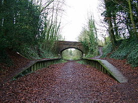
Track was finally lifted in 1969, as the railway was still open until the closure of the goods terminal at
457:
47:
465:
17:
407:
https://web.archive.org/web/20090107031846/http://www.sdjr.net/locations/charlton_marshall.html
383:
373:
356:
346:
321:
311:
63:
469:
200:
329:
370:
Jowett's
Railway Atlas of Great Britain and Ireland: From Pre-Grouping to the Present Day
512:
394:
297:
211:
that year. The site was in a cutting, which now part of a footpath and bridleway.
67:
301:
434:
421:
360:
387:
333:
325:
307:
411:
176:
345:(1st ed.). Penryn, Cornwall: Atlantic Transport Publishers.
179:. It was located between Blandford Forum and Bailey Gate on the
183:. The station consisted of two short platforms and shelters.
473:
150:
142:
134:
129:
115:
110:
102:
97:
89:
75:
59:
54:
34:
524:Former Somerset and Dorset Joint Railway stations
372:(1st ed.). Sparkford: Patrick Stephens Ltd.
534:Railway stations in Great Britain closed in 1956
529:Railway stations in Great Britain opened in 1928
493:
191:The station was opened on 5 July 1928 by the
8:
500:
486:
31:
539:South West England railway station stubs
464:This article about a railway station in
216:
281:
175:was a station in the English county of
412:http://www.geograph.org.uk/photo/22206
146:Closed (except special schools trains)
7:
454:
452:
343:Jowett's Nationalised Railway Atlas
255:Somerset & Dorset Joint Railway
124:Southern Region of British Railways
519:Disused railway stations in Dorset
472:. You can help Knowledge (XXG) by
27:Disused railway station in England
25:
181:Somerset and Dorset Joint Railway
18:Charlton Marshall railway station
456:
250:London and South Western Railway
46:
1:
395:Station on navigable O.S. map
288:BR Plymouth Division records
368:Jowett, Alan (March 1989).
154:last used by schools trains
555:
451:
195:. It became part of the
262:
248:
236:
166:
162:
158:
45:
310:: Patrick Stephens Ltd.
268:Line and station closed
242:Line and station closed
173:Charlton Marshall Halt
38:Charlton Marshall Halt
341:Jowett, Alan (2000).
435:50.83537°N 2.14701°W
431: /
55:General information
466:South West England
440:50.83537; -2.14701
232:Following station
220:Preceding station
481:
480:
379:978-1-85260-086-0
352:978-0-906899-99-1
317:978-1-85260-508-7
273:
272:
269:
257:
243:
226:Disused railways
170:
169:
143:17 September 1956
98:Other information
64:Charlton Marshall
16:(Redirected from
546:
502:
495:
488:
460:
453:
446:
445:
443:
442:
441:
436:
432:
429:
428:
427:
424:
391:
364:
337:
306:(1st ed.).
300:(October 1995).
289:
286:
267:
253:
241:
217:
201:British Railways
193:Southern Railway
151:17 December 1963
85:
50:
32:
21:
554:
553:
549:
548:
547:
545:
544:
543:
509:
508:
507:
506:
449:
439:
437:
433:
430:
425:
422:
420:
418:
417:
403:
380:
367:
353:
340:
318:
296:
293:
292:
287:
283:
278:
266:
264:Blandford Forum
252:
240:
214:
197:Southern Region
189:
122:
81:
70:
41:
40:
39:
28:
23:
22:
15:
12:
11:
5:
552:
550:
542:
541:
536:
531:
526:
521:
511:
510:
505:
504:
497:
490:
482:
479:
478:
461:
415:
414:
409:
402:
401:External links
399:
398:
397:
392:
378:
365:
351:
338:
316:
298:Butt, R. V. J.
291:
290:
280:
279:
277:
274:
271:
270:
261:
258:
247:
244:
234:
233:
230:
227:
224:
221:
188:
185:
168:
167:
164:
163:
160:
159:
156:
155:
152:
148:
147:
144:
140:
139:
136:
132:
131:
127:
126:
117:
113:
112:
108:
107:
104:
100:
99:
95:
94:
91:
87:
86:
79:
77:Grid reference
73:
72:
61:
57:
56:
52:
51:
43:
42:
37:
36:
35:
26:
24:
14:
13:
10:
9:
6:
4:
3:
2:
551:
540:
537:
535:
532:
530:
527:
525:
522:
520:
517:
516:
514:
503:
498:
496:
491:
489:
484:
483:
477:
475:
471:
467:
462:
459:
455:
450:
447:
444:
413:
410:
408:
405:
404:
400:
396:
393:
389:
385:
381:
375:
371:
366:
362:
358:
354:
348:
344:
339:
335:
331:
327:
323:
319:
313:
309:
305:
304:
299:
295:
294:
285:
282:
275:
265:
259:
256:
251:
245:
239:
235:
231:
228:
225:
222:
219:
218:
215:
212:
210:
205:
202:
198:
194:
186:
184:
182:
178:
174:
165:
161:
157:
153:
149:
145:
141:
137:
133:
128:
125:
121:
118:
116:Post-grouping
114:
109:
105:
101:
96:
92:
88:
84:
80:
78:
74:
69:
65:
62:
58:
53:
49:
44:
33:
30:
19:
474:expanding it
463:
448:
416:
369:
342:
302:
284:
213:
206:
190:
172:
171:
68:North Dorset
29:
438: /
135:5 July 1928
513:Categories
423:50°50′07″N
276:References
238:Spetisbury
426:2°08′49″W
361:228266687
334:11956311M
308:Sparkford
209:Blandford
130:Key dates
90:Platforms
388:22311137
326:60251199
83:ST897039
60:Location
260:
246:
229:
223:
187:History
111:History
106:Disused
71:England
386:
376:
359:
349:
332:
324:
314:
177:Dorset
138:Opened
103:Status
468:is a
470:stub
384:OCLC
374:ISBN
357:OCLC
347:ISBN
322:OCLC
312:ISBN
199:of
515::
382:.
355:.
330:OL
328:.
320:.
120:SR
66:,
501:e
494:t
487:v
476:.
390:.
363:.
336:.
93:2
20:)
Text is available under the Creative Commons Attribution-ShareAlike License. Additional terms may apply.