40:
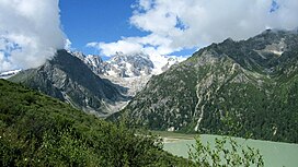
331:, is 6,168 metres (20,236 ft) above sea level. Other significant peaks include Dophu Ngatra (6,119m) and Zhiltrön (5,988m). All three peaks have glaciers on their northern faces and the entire range possesses almost twelve glaciers in total with some descending as low as 4,100 metres (13,500 ft). The Chola Mountains form part of the
540:. In 2016, the Chinese government completed construction of a new 7 km (4.3 mi) long tunnel bypassing the mountain pass and is the highest vehicular tunnel in the world.
473:
regions. The Chola foothills possessed hundreds of monasteries until
Chinese annexation in the 20th century. Many of these monasteries were associated with fringe branches of
628:
162:
573:
423:
279:. However, others claim, Chola is just another name for snow mountain, given by local Tibetans. Due to the Chinese transliteration of the mountains into
528:. Derge remains as the primary urban centre in the mountain range, although the Pal Chu and Me Chu valleys also contain concentrations of villages.
466:
171:
283:
and its common usage on official maps, the mountain range is sometimes mistakenly translated into "Sparrow
Mountains" or "Bird Mountains".
532:, also known as the Northern Sichuan-Tibet Highway, crosses the range at 4,916 metres (16,129 ft) above sea level via Cho La between
773:
299:
with the
Eurasian Plate. The Chola Mountains lie on the northeastern edge of a semi-independent tectonic block as part of the greater
85:
729:
705:
678:
650:
431:
427:
482:
246:
398:
380:
362:
344:
238:
78:
574:"Late Cenozoic deformation along the northwestern continuation of the Xianshuihe fault system, Eastern Tibetan Plateau"
604:
529:
304:
622:
296:
422:
On the southwestern slopes and at lower elevations, the Chola
Mountains are covered by sections of the
588:
415:). Numerous glacial-fed lakes have formed along the northeastern edge of the Chola Mountains, with
465:(Cho Pass) was an important link across the mountains, connecting Derge and central Tibet with the
506:
502:
498:
725:
701:
674:
646:
494:
445:
The Chola
Mountain's southwestern hills and valleys were historically at the heartland of the
206:
189:
166:
596:
517:
490:
474:
446:
272:
222:
218:
210:
462:
332:
312:
292:
268:
592:
303:. The mountains range's abrupt northeastern edge is formed by the Ganzi segment of the
745:
308:
300:
182:
493:. Today, major monasteries in the Chola Mountains' foothills and valleys include the
767:
470:
328:
295:, the Chola Mountains are a result of uplift caused during the Indian subcontinent's
264:
61:
525:
416:
340:
45:
513:
17:
100:
87:
533:
434:
324:
39:
524:. A small portion of the mountains in the south pass into neighbouring
521:
478:
336:
323:
The Chola
Mountains run in a northwest to southeast direction with the
175:
343:
watersheds. Major tributaries to the southwest include the Zhil Chu (
600:
559:
Lake Region of Sikkim, on the
Frontier of Tibet (Geography, Volume 3)
406:
388:
370:
352:
254:
68:
537:
486:
458:
454:
214:
155:
512:
Administratively, today the Chola
Mountains are primarily within
450:
327:
nearest to the range's northeastern edge. The highest peak,
461:, located in the Zhil Chu valley of the Chola foothills.
426:. To the north and east, the Tibetan Plateau consists of
225:
monasteries can be found in the mountain range's valleys.
746:"Tibet less remote as world's highest road tunnel opens"
397:), while the northeastern flanks possess the Tro Chu (
233:
The
Chinese transliteration of the Chola Mountains is
673:. Seattle, WA: The Mountaineer's Books. p. 308.
135:
263:). The Chola Mountains are named after the primary
181:
161:
151:
146:
121:
116:
77:
67:
57:
52:
32:
217:. The mountains were once at the centre of the
572:Wang S., Fan C., Wang G. & Wang E. (2008).
419:in the Tro Chu valley being the most notable.
128:
8:
627:: CS1 maint: multiple names: authors list (
424:Hengduan Mountains subalpine conifer forests
561:. Great Britain: Royal Geographic Society.
29:
27:Mountain range in Sichuan Province, China
724:. Beijing, China: Star Map Press. 2013.
645:. Beijing, China: SinoMaps Press. 2006.
664:
662:
549:
620:
581:Geological Society of America Bulletin
7:
692:
690:
748:. Xinhua. People. 10 November 2016
671:Trekking Tibet: A Traveler's Guide
25:
432:Southeast Tibet shrub and meadows
428:montane grasslands and shrublands
205:, are a northern subrange of the
38:
411:
402:
393:
384:
375:
366:
357:
348:
259:
250:
242:
1:
457:. The kingdom's capital was
73:6,168 m (20,236 ft)
136:
33:Chola Mountainsཁྲོ་ལ་རི་བོ།
790:
774:Mountain ranges of Sichuan
129:
37:
557:Temple, Richard (1881).
307:where two blocks of the
201:, also romanized as the
700:. Lonely Planet. 2007.
291:Located in the eastern
530:National Highway G-317
271:or Tro La. Cho La in
101:31.78583°N 99.07278°E
722:Sichuan Sheng Dituce
669:McCue, Gary (2010).
313:strike-slip movement
267:crossing the range,
44:Rongme Ngatra above
593:2008GSAB..120..312W
247:traditional Chinese
97: /
507:Dzogchen Monastery
503:Dzongsar Monastery
499:Gongchen Monastery
335:between the Upper
239:simplified Chinese
106:31.78583; 99.07278
53:Highest point
698:China's Southwest
495:Palpung Monastery
311:are experiencing
221:and many remnant
207:Shaluli Mountains
195:
194:
190:Shaluli Mountains
16:(Redirected from
781:
758:
757:
755:
753:
742:
736:
735:
718:
712:
711:
694:
685:
684:
666:
657:
656:
639:
633:
632:
626:
618:
616:
615:
609:
603:. Archived from
601:10.1130/B25833.1
587:(3–4): 312–327.
578:
569:
563:
562:
554:
518:Garze Prefecture
475:Tibetan Buddhism
413:
404:
395:
386:
377:
368:
359:
350:
305:Xianshuihe Fault
261:
252:
244:
223:Tibetan Buddhist
219:Kingdom of Derge
211:Sichuan Province
185:
139:
132:
131:
112:
111:
109:
108:
107:
102:
98:
95:
94:
93:
90:
42:
30:
21:
789:
788:
784:
783:
782:
780:
779:
778:
764:
763:
762:
761:
751:
749:
744:
743:
739:
732:
720:
719:
715:
708:
696:
695:
688:
681:
668:
667:
660:
653:
641:
640:
636:
619:
613:
611:
607:
576:
571:
570:
566:
556:
555:
551:
546:
443:
379:), and Me Chu (
333:drainage divide
321:
293:Tibetan Plateau
289:
231:
203:Trola Mountains
199:Chola Mountains
183:
142:
105:
103:
99:
96:
91:
88:
86:
84:
83:
48:
28:
23:
22:
15:
12:
11:
5:
787:
785:
777:
776:
766:
765:
760:
759:
737:
730:
713:
706:
686:
679:
658:
651:
643:Atlas of China
634:
564:
548:
547:
545:
542:
442:
441:Human activity
439:
430:including the
320:
317:
315:under stress.
309:tectonic plate
301:Eurasian Plate
288:
285:
230:
227:
193:
192:
187:
179:
178:
169:
159:
158:
153:
149:
148:
144:
143:
141:
140:
133:
125:
123:
119:
118:
114:
113:
81:
75:
74:
71:
65:
64:
59:
55:
54:
50:
49:
43:
35:
34:
26:
24:
18:Chola Mountain
14:
13:
10:
9:
6:
4:
3:
2:
786:
775:
772:
771:
769:
747:
741:
738:
733:
731:9787547109151
727:
723:
717:
714:
709:
707:9781741041859
703:
699:
693:
691:
687:
682:
680:9781594852664
676:
672:
665:
663:
659:
654:
652:9787503141782
648:
644:
638:
635:
630:
624:
610:on 2014-02-23
606:
602:
598:
594:
590:
586:
582:
575:
568:
565:
560:
553:
550:
543:
541:
539:
535:
531:
527:
523:
519:
515:
510:
508:
504:
500:
496:
492:
491:Rimé movement
488:
484:
480:
476:
472:
471:Sichuan basin
468:
464:
460:
456:
452:
448:
447:Derge Kingdom
440:
438:
436:
433:
429:
425:
420:
418:
414:
408:
400:
396:
390:
382:
378:
372:
364:
360:
354:
346:
342:
339:(Jinsha) and
338:
334:
330:
329:Rongme Ngatra
326:
318:
316:
314:
310:
306:
302:
298:
294:
286:
284:
282:
278:
274:
270:
266:
262:
256:
248:
240:
236:
228:
226:
224:
220:
216:
212:
208:
204:
200:
191:
188:
186:
180:
177:
173:
170:
168:
164:
160:
157:
154:
150:
145:
138:
134:
127:
126:
124:
120:
115:
110:
82:
80:
76:
72:
70:
66:
63:
62:Rongme Ngatra
60:
56:
51:
47:
41:
36:
31:
19:
750:. Retrieved
740:
721:
716:
697:
670:
642:
637:
623:cite journal
612:. Retrieved
605:the original
584:
580:
567:
558:
552:
526:Baiyu County
511:
444:
421:
417:Yihun Lhatso
410:
392:
374:
361:), Pal Chu (
356:
341:Yalong River
322:
290:
280:
276:
258:
234:
232:
209:in western
202:
198:
196:
184:Parent range
46:Yihun Lhatso
514:Dege County
260:Què'ér Shān
235:Que Er Shan
137:Què'ér Shān
122:Native name
104: /
79:Coordinates
614:2017-03-17
544:References
489:, and the
477:including
453:region of
163:Prefecture
92:99°04′22″E
89:31°47′09″N
534:Manigango
435:ecoregion
325:ridgeline
319:Geography
297:collision
277:Lake Pass
229:Etymology
147:Geography
69:Elevation
768:Category
167:Province
752:21 July
589:Bibcode
522:Sichuan
479:Nyingma
449:in the
412:Zhāo Qū
399:Chinese
381:Chinese
363:Chinese
345:Chinese
337:Yangtze
287:Geology
273:Tibetan
176:Sichuan
152:Country
728:
704:
677:
649:
505:, and
463:Cho La
409::
407:pinyin
401::
394:Mài Qū
391::
389:pinyin
383::
376:Bái Qū
373::
371:pinyin
365::
355::
353:pinyin
347::
281:Què'ér
275:means
269:Cho La
257::
255:pinyin
249::
241::
117:Naming
608:(PDF)
577:(PDF)
538:Derge
520:, in
487:Kagyu
483:Sakya
467:Garze
459:Derge
455:Tibet
358:Sè Qū
215:China
172:Garze
156:China
754:2017
726:ISBN
702:ISBN
675:ISBN
647:ISBN
629:link
536:and
469:and
451:Kham
265:pass
197:The
58:Peak
597:doi
585:120
251:雀兒山
243:雀儿山
130:雀儿山
770::
689:^
661:^
625:}}
621:{{
595:.
583:.
579:.
516:,
509:.
501:,
497:,
485:,
481:,
437:.
405:;
403:朝曲
387:;
385:麦曲
369:;
367:白曲
351:;
349:色曲
253:;
245:;
213:,
174:,
165:/
756:.
734:.
710:.
683:.
655:.
631:)
617:.
599::
591::
237:(
20:)
Text is available under the Creative Commons Attribution-ShareAlike License. Additional terms may apply.