342:
125:
161:
134:
143:
116:
152:
105:." The findings from the survey work have suggested that there is a deeper timeframe for occupation at Clonca, perhaps as a precursor to the ecclesiastical establishment. In scale and outline structure both the Carrowmore and Clonca complexes are comparable with, for example, the combined inner and middle enclosures of
102:
On its south and east sides, the graveyard appears to once have occupied a more extensive area. In an arc around the graveyard from the north, to the west and south-west sides, at the edge of the plateau of land where the downslope to the valley floor begins, are the outlines of a double circle with
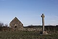
92:. In the field opposite the entrance to the church are two crosses: the upright (high) cross has both panels carved with interlace and figurative scenes: two lions and two individuals thought to be St. Paul and St. Anthony with the scenes thought to depict the
99:
In 2013, an archaeological geophysical (magnetometer) survey was undertaken at the site and the surrounding fields which recorded a double ditch circular boundary surrounding the graveyard with the standing high cross within and part of the complex.
96:, and other less identifiable scenes. To the north-west of the upright cross are the remnants of the ringed head of another (high) cross (a piece of cross-arm stored in the church is thought to be a fragment of this second feature).
406:
72:
The site occupies level ground on the edge of the valley floor of the
Gleneely River. Erenaghs (lay Stewards) are recorded as being on the site in the early 17th Century. The 17th or 18th century
387:
411:
103:
diameters of some 80m and 95m. This looks like a precinct similar to that at
Carrowmore, but in a much more complex landscape setting
228:
193:
93:
21:
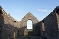
60:. It is one of the most important and popular historical sites in Inishowen. At 54°43′05″N it is the northernmost of Ireland's
380:
257:"THE EARLY ECCLESIASTICAL COMPLEXES OF CARROWMORE AND CLONCA AND THEIR LANDSCAPE CONTEXT IN INISHOWEN, COUNTY DONEGAL"
61:
373:
341:
85:
287:"Making Christian Landscapes in Atlantic Europe: Conversion and Consolidation in the Early Middle Ages"
76:
stands on the site of an earlier monastic site and enclosure, likely founded around the 6th century by
81:
286:
77:
318:
268:
234:
224:
199:
189:
106:
73:
357:
349:
57:
400:
124:
160:
322:
272:
36:
23:
255:
O'BRIEN, COLM; ADAMS, MAX; HAYCOCK, DEB; O'MEARA, DON; PENNIE, JACK (2013).
238:
133:
53:
142:
115:
218:
203:
89:
256:
151:
353:
183:
312:
185:
Medieval religious houses: Ireland: with an appendix to early sites,
80:. The lintel over this later church doorway - with worn carvings of
220:
Irish high crosses : with the figure sculptures explained
84:- is part of an older church. Inside lies the tombstone of
361:
407:
Religious buildings and structures in County
Donegal
311:
Ireland., Archaeological Survey of
Northern (1969).
109:
as they survive in their visible stone-walled form.
381:
8:
388:
374:
348:This article related to the geography of
188:. R. Neville Hadcock. Harlow: Longmans.
314:An archaeological survey of County Down
174:
111:
7:
338:
336:
250:
248:
52:, is a historic monument located in
223:. Drogheda: Boyne Valley Honey Co.
16:Historic monument in County Donegal
360:. You can help Knowledge (XXG) by
14:
340:
159:
150:
141:
132:
123:
114:
94:Miracle of the loaves and fishes
88:, probably a Scotsman from the
412:County Donegal geography stubs
1:
261:Ulster Journal of Archaeology
291:www.corkuniversitypress.com
428:
335:
50:Clonca Church & Cross
217:Harbison, Peter (1994).
182:Gwynn, Aubrey (1970).
37:55.267882°N 7.173547°W
42:55.267882; -7.173547
33: /
86:Magnus MacOrristin
62:National Monuments
369:
368:
74:Church of Ireland
419:
390:
383:
376:
344:
337:
327:
326:
308:
302:
301:
299:
297:
283:
277:
276:
252:
243:
242:
214:
208:
207:
179:
163:
154:
145:
136:
127:
118:
48:
47:
45:
44:
43:
38:
34:
31:
30:
29:
26:
427:
426:
422:
421:
420:
418:
417:
416:
397:
396:
395:
394:
333:
331:
330:
310:
309:
305:
295:
293:
285:
284:
280:
254:
253:
246:
231:
216:
215:
211:
196:
181:
180:
176:
171:
164:
155:
146:
137:
128:
119:
70:
41:
39:
35:
32:
27:
24:
22:
20:
19:
17:
12:
11:
5:
425:
423:
415:
414:
409:
399:
398:
393:
392:
385:
378:
370:
367:
366:
350:County Donegal
345:
329:
328:
303:
278:
244:
229:
209:
194:
173:
172:
170:
167:
166:
165:
158:
156:
149:
147:
140:
138:
131:
129:
122:
120:
113:
69:
66:
58:County Donegal
15:
13:
10:
9:
6:
4:
3:
2:
424:
413:
410:
408:
405:
404:
402:
391:
386:
384:
379:
377:
372:
371:
365:
363:
359:
355:
351:
346:
343:
339:
334:
324:
320:
316:
315:
307:
304:
292:
288:
282:
279:
274:
270:
266:
262:
258:
251:
249:
245:
240:
236:
232:
230:0-9517823-7-1
226:
222:
221:
213:
210:
205:
201:
197:
195:0-582-11229-X
191:
187:
186:
178:
175:
168:
162:
157:
153:
148:
144:
139:
135:
130:
126:
121:
117:
112:
110:
108:
104:
97:
95:
91:
87:
83:
82:ecclesiastics
79:
75:
67:
65:
63:
59:
55:
51:
46:
362:expanding it
347:
332:
313:
306:
294:. Retrieved
290:
281:
264:
260:
219:
212:
184:
177:
101:
98:
71:
49:
18:
317:. H.M.S.O.
267:: 142–160.
40: /
401:Categories
169:References
78:St. Baudan
25:55°16′04″N
323:941012496
296:12 August
273:0082-7355
54:Inishowen
28:7°10′25″W
239:31925760
90:Hebrides
354:Ireland
107:Nendrum
68:History
321:
271:
237:
227:
202:
192:
356:is a
204:96266
358:stub
319:OCLC
298:2022
269:ISSN
235:OCLC
225:ISBN
200:OCLC
190:ISBN
403::
352:,
289:.
265:72
263:.
259:.
247:^
233:.
198:.
64:.
56:,
389:e
382:t
375:v
364:.
325:.
300:.
275:.
241:.
206:.
100:"
Text is available under the Creative Commons Attribution-ShareAlike License. Additional terms may apply.