463:
634:
caused higher than normal temperatures in areas that would typically remain under snow. These areas received rain instead of snow, and the rivers began to run earlier and with far more volume than normal. Rivers in the southern part of
Arizona at that time contained anywhere from three to nearly six times their normal amount of water. To complicate matters, the snowpack was already 150% the normal amount. Dam operators for Coolidge Dam released water in record levels because storage capacity had been reached.
1720:
347:
372:
654:
expected maximum release rate of 133 cubic metres per second (4,700 cu ft/s), and was the highest release rate for the dam since its construction. Discharge at
Winkleman was recorded at 1,050 cubic metres per second (37,000 cu ft/s) on January 20, 1993. Winkleman Flats, a small area near Winkleman, was flooded as well. However, despite earlier concerns about the dam's safety, it survived the flood even though retrofit work was in process at the time.
34:
1731:
1192:
1164:
526:
1178:
379:
354:
542:(BIA), which also owns and operates it, at a cost of US$ 10 million. The overall structure used 200,000 cubic yards (150,000 m) of concrete and consists of three domes, which are supported by buttresses on 100-foot (30 m) centers. It rises 249 feet (76 m), with a crest length of 580 feet (180 m). Two uncontrolled ogee crest
649:
were "scoured" or uncovered by the force of the water and failed. The water flow was concentrated through the release gates, as opposed to letting the water overtop the dam, which would have created a different scour rate. The force of the Gila River undermined and ultimately caused the failure of
611:
wells, local towns, rural users, and mining operations. The diesel generators no longer function, therefore electricity is delivered to SCIP by the
Western Area Power Administration. However, flood damage in 1983 rendered the hydroelectric station inoperable and restoration plans have been deemed
633:
In
January 1993, heavy rainfall (up to three times the normal amount) in Arizona filled San Carlos Lake, and the operators were forced to release excess water. The ground was saturated, and the continuing rainfall ran off into the streams and rivers. In addition, the weather pattern for the year
663:
675:
San Carlos Lake is stocked periodically, and when the winter has experienced average or above average precipitation, is one of the largest lakes in
Arizona. The San Carlos Apache Tribe Recreation & Wildlife Dept. stocks several species of fish using various methods to create a good fishing
653:
The flow into San Carlos Lake (from the Gila and San Carlos rivers) during
January 1993 peaked between 3,000 to 3,500 cubic metres per second (110,000 to 120,000 cu ft/s). The flow from Coolidge Dam reached 927 cubic metres per second (32,700 cu ft/s), about seven times the
624:
completed a study that concluded that the dam needed modifications to prevent a failure should a significant flood or an earthquake occur. Earlier floods that had resulted in water topping the dam had eroded the abutments, and the buttresses were judged to be unstable. Work started in 1991 and
1609:
1704:
1640:
1624:
1614:
512:
Since the water is impounded so it can be released when farmers need it, San Carlos Lake is often at a low level except in wet periods. When former
President Coolidge dedicated the dam in 1930, the dam had not begun to fill. Humorist
738:. Jet-skiing, water skiing and boating are allowed. Individuals who are not members of the San Carlos Apache tribe who wish to use the lake must contact the tribal office for a permit since the lake is on tribal land.
2347:
1699:
1645:
2282:
1286:
1666:
1568:
612:
infeasible. The electric plant at the dam was completed and began generating electricity in 1935, and the diesel plant was completed in
December of that year and produced electricity the following year.
2317:
1599:
1533:
1498:
1573:
1478:
1438:
1263:
1538:
1528:
1523:
1503:
1619:
1453:
1368:
1488:
1483:
1358:
2292:
1578:
1543:
1448:
1423:
2287:
1563:
1513:
1493:
1468:
1458:
1443:
1433:
1418:
1398:
1373:
1363:
1353:
756:
When they reach the dam, cyclists can either return to the starting point along the two-lane paved road, or they can continue eastward along the rougher part of the road until it rejoins
2337:
1583:
1558:
1463:
1403:
1383:
1378:
1348:
1338:
1055:
1518:
1473:
1413:
1388:
1343:
845:
1650:
1548:
1428:
1393:
753:
at the dam is about the same as the starting point, so the trip is not strictly a climb, but peaks about the middle of the distance and then descends again to about 2,600 ft.
1604:
1553:
1508:
1408:
2322:
625:
included an access road to the downstream side of the dam. The work concluded in 1995. The final cost was estimated at $ US46.5 million. ($ 84.9 million in 2023 dollars)
1767:
1316:
1301:
1256:
494:
and was dedicated by
President Coolidge on March 4, 1930. The design and construction engineer was Herman Neuffer, who oversaw much of the construction undertaken by the
1332:
2332:
2312:
1734:
1249:
749:
can ride the access road to the dam face and back. The route is scenic and little-traveled, and rises a total of about 700 feet along the 13 mile route. The
2357:
1724:
2352:
462:
490:. Built between 1924 and 1928, the Coolidge Dam was part of the San Carlos Irrigation Project. Coolidge Dam was named after the 30th US president,
2342:
1760:
1296:
607:
also run by the
Project was built simultaneously and located on withdrawn land near the town of Coolidge. The latter facility provided power for
993:
1925:
2063:
1147:
1100:
1038:
976:
949:
2037:
1272:
1061:
853:
826:
506:
371:
328:
39:
1753:
1687:
346:
75:
1776:
604:
2327:
1215:
804:
2150:
1235:
1210:
912:
600:
529:
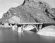
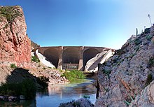
Coolidge Dam from downstream, showing its unique reinforced concrete multiple dome and buttress construction. 2009 photo
2047:
1998:
1816:
2188:
2032:
1988:
1844:
1993:
563:
1864:
1859:
1796:
1692:
1671:
637:
As a result of the heavy water releases, several El Paso Natural Gas pipelines, which crossed the Gila River near
2101:
2016:
1899:
1821:
1811:
2302:
2211:
2161:
2155:
1801:
757:
539:
495:
2216:
1904:
1849:
1197:
1884:
1839:
1092:
Storm-induced geologic hazards: case histories from the 1992-1993 winter in southern California and Arizona
2297:
2086:
2073:
2042:
2008:
1970:
1879:
1874:
1306:
1889:
1854:
2096:
1980:
1894:
1869:
1311:
1291:
831:
621:
62:
1909:
1002:
1965:
58:
2307:
662:
475:
2206:
1806:
642:
302:
764:
or other rugged type bicycle is recommended for cyclists traveling east from the dam to Rte 70.
590:
of the dead, so a concrete slab was laid over the principal burial ground at a cost of $ 11,000.
2134:
1225:
1143:
1117:
1096:
1054:
United States. Dept. of the Interior. Office of Inspector General; Robert J. Williams (1998).
1034:
972:
945:
887:
650:
the north and south abutments of the bridge crossing at Attaway Road, upstream from Coolidge.
638:
1090:
1057:
Audit report: safety of dams project constructed by the Bureau of Reclamation at Coolidge Dam
875:
562:
tribe, who feared a violation of their treaty rights, according to an author writing for the
2129:
2091:
2081:
1241:
1230:
279:
1955:
1940:
690:
646:
502:
491:
1950:
1169:
790:
571:
483:
442:
2276:
2200:
2124:
2119:
761:
735:
289:
1705:
University and college buildings listed on the National Register of Historic Places
1183:
603:(SCIIP), Coolidge Dam formerly generated electricity from a hydroelectric plant. A
517:
looked at the grass in the lake bed, and said, "If this were my lake, I'd mow it."
479:
525:
1028:
966:
939:
760:. Before traveling on the reservation, non-tribe members must obtain a permit. A
1191:
916:
785:
731:
587:
514:
1960:
1945:
1159:
746:
608:
487:
891:
90:
77:
1935:
1745:
1177:
750:
579:
543:
575:
547:
215:
168:
1219:
33:
1780:
1095:(Illustrated ed.). Geological Society of America. pp. 26–27.
712:
701:
680:
586:
the bodies but the Apache vehemently objected to what they considered
1700:
List of jails and prisons on the National Register of Historic Places
583:
559:
1222:", 154 photos, 141 data pages, 10 photo caption pages
1089:
Slosson, James E.; Robert A. Larson (1997). Robert A. Larson (ed.).
661:
524:
461:
821:
1142:(Illustrated ed.). Big Earth Publishing. pp. 158–159.
295:
1749:
1245:
1226:
Southwest Tribal Fisheries Commission – San Carlos Apache Tribe
570:
A compromise was finally made with the Indians, and the tribal
578:
started his bloody raids now lie deep under the waters of the
163:
2348:
National Register of Historic Places in Gila County, Arizona
971:(Reprint ed.). The Lawbook Exchange, Ltd. p. 302.
2283:
Dams on the National Register of Historic Places in Arizona
730:
Other fish are stocked from cold-water fisheries including
538:
Coolidge Dam was constructed between 1924 and 1928 by the
509:. The project irrigates 100,000 acres (40,000 ha).
415:
Major C.R. Olberg; Atkinson, Kier Bros. & Spice Co.
2318:
Former hydroelectric power plants in the United States
995:
Integrated Resource Plan San Carlos Irrigation Project
558:
Construction of the dam incurred opposition from the
2229:
2143:
2110:
2072:
2056:
2025:
2007:
1979:
1918:
1830:
1787:
1680:
1659:
1633:
1592:
1325:
1302:
History of the National Register of Historic Places
1279:
448:
435:
427:
419:
411:
403:
395:
301:
288:
278:
270:
262:
257:
245:
237:
232:
224:
214:
206:
198:
190:
182:
174:
162:
157:
149:
145:
US$ 10 million ($ 145 million in 2023 dollars)
141:
122:
114:
106:
69:
54:
46:
26:
1220:Coolidge Dam, Gila River, Peridot, Gila County, AZ
676:environment. Several species are self-sustaining:
498:(BIA) during the 1920s in Arizona and New Mexico.
2293:Buildings and structures in Pinal County, Arizona
1333:List of U.S. National Historic Landmarks by state
779:
777:
2288:Buildings and structures in Gila County, Arizona
1140:Cycling Arizona: The Statewide Road Biking Guide
2338:Historic American Engineering Record in Arizona
2222:Wellton-Mohawk Irrigation and Drainage District
1725:National Register of Historic Places portal
784:Johnston, Louis; Williamson, Samuel H. (2023).
941:Arizona, The Grand Canyon State: A State Guide
1761:
1257:
8:
886:(1). Bonnier Corporation: 66. January 1929.
21:Dam in Gila County and Pinal County, Arizona
2323:United States Bureau of Indian Affairs dams
2260:Sulphur Springs Valley Electric Cooperative
1033:. the University of Michigan. p. 240.
2197:Hohokam Irrigation & Drainage District
1768:
1754:
1746:
1264:
1250:
1242:
1084:
1082:
915:. US Bureau of Reclamation. Archived from
32:
23:
1273:U.S. National Register of Historic Places
329:U.S. National Register of Historic Places
1138:Maxa, Christine; David A. James (2007).
876:"Huge Domes Strengthen New Coolidge Dam"
846:"Arizona scenic drive: Globe to Safford"
210:200,000 cu yd (150,000 m)
2333:Energy infrastructure completed in 1930
1231:The American Southwest: San Carlos Lake
1118:"Southwest Tribal Fisheries Commission"
1027:United States. Congress. House (1938).
773:
666:Gila River downstream from Coolidge Dam
546:are concrete-lined and located on each
16:Dam in Gila and Pinal Counties, Arizona
822:"National Register Information System"
2313:Hydroelectric power plants in Arizona
944:. US History Publishers. p. 14.
7:
2212:San Carlos Indian Irrigation Project
2092:Morenci Water & Electric Company
1216:Historic American Engineering Record
827:National Register of Historic Places
601:San Carlos Indian Irrigation Project
507:San Carlos Apache Indian Reservation
378:
353:
40:Historic American Engineering Record
38:Upstream face of Coolidge Dam, from
2130:City of Safford Electric Department
482:31 miles (50 km) southeast of
2358:Native American history of Arizona
2251:Graham County Electric Cooperative
2245:Duncan Valley Electric Cooperative
2236:Arizona Electric Power Cooperative
1688:National Historic Preservation Act
14:
938:Federal Writers' Project (1966).
2353:Former power stations in Arizona
2194:Harquahala Valley Power District
2120:Mesa Energy Resources Department
1730:
1729:
1718:
1190:
1176:
1162:
852:. 2 October 2015. Archived from
605:diesel electric generating plant
377:
370:
352:
345:
805:Gross Domestic Product deflator
2343:1924 establishments in Arizona
2257:Navopache Electric Cooperative
1641:Federated States of Micronesia
1287:Architectural style categories
595:Hydroelectric power generation
437:
1:
2239:Columbus Electric Cooperative
786:"What Was the U.S. GDP Then?"
386:Show map of the United States
574:and the old camp from which
554:Opposition from Apache tribe
191:Elevation at crest
2254:Mohave Electric Cooperative
2189:Gila River Indian Community
1060:. p. 3. Archived from
1001:. p. 3. Archived from
2374:
2263:Trico Electric Cooperative
1693:Historic Preservation Fund
1672:American Legation, Morocco
965:Bennett, Elmer F. (2008).
249:910,000 acre⋅ft (1.12
194:2,535 ft (773 m)
2185:Electrical District No. 8
2182:Electrical District No. 7
2179:Electrical District No. 6
2176:Electrical District No. 5
2173:Electrical District No. 4
2170:Electrical District No. 3
2167:Electrical District No. 2
2102:UniSource Energy Services
1713:
1634:Lists by associated state
1211:USBR Coolidge Dam Website
1116:San Carlos Apache Tribe.
992:State of Arizona (2005).
456:
436:NRHP reference
339:
335:
326:
319:
315:
311:
31:
2203:Tribal Utility Authority
2156:Ak-Chin Indian Community
1615:Northern Mariana Islands
616:Structural modifications
564:Federal Writers' Project
540:Bureau of Indian Affairs
496:Bureau of Indian Affairs
428:Architectural style
202:580 ft (180 m)
153:Bureau of Indian Affairs
91:33.174687°N 110.527863°W
2151:Aha Macav Power Service
2082:Ajo Improvement Company
1218:(HAER) No. AZ-7, "
1198:Renewable energy portal
303:Installed capacity
186:249 ft (76 m)
115:Construction began
2328:Dams completed in 1930
2087:Arizona Public Service
2074:Investor-owned utility
1610:Minor Outlying Islands
1593:Lists by insular areas
1307:Keeper of the Register
706:Pomoxis nigromaculatus
667:
592:
530:
501:Coolidge Dam impounds
467:
466:View of the lake, 2010
399:21 acres (8.5 ha)
271:Decommission date
142:Construction cost
96:33.174687; -110.527863
2162:Colorado River Agency
2125:Page Electric Utility
2097:Tucson Electric Power
1312:National Park Service
1292:Contributing property
832:National Park Service
695:Micropterus salmoides
665:
622:Bureau of Reclamation
582:. It was proposed to
568:
528:
465:
164:Type of dam
2009:Solar thermal plants
1667:District of Columbia
856:on 22 September 2020
263:Commission date
241:San Carlos Reservoir
2164:Electrical Services
2144:Government agencies
2026:Photovoltaic plants
1833:generating stations
1790:generating stations
1030:Hearings, Volume 10
807:figures follow the
724:Pylodictis olivaris
717:Ictalurus punctatus
671:Fishing and boating
476:reinforced concrete
361:Show map of Arizona
246:Total capacity
129:(94 years ago)
87: /
2207:Salt River Project
2135:Thatcher Utilities
2113:municipality owned
1971:Theodore Roosevelt
1919:Hydroelectric dams
968:Federal Indian Law
919:on 31 October 2001
722:flathead catfish (
668:
531:
478:multiple dome and
468:
225:Spillway type
199:Width (crest)
2270:
2269:
2219:Utility Authority
2191:Utility Authority
2158:Electric Utility
1797:Abitibi Snowflake
1743:
1742:
1297:Historic district
1149:978-1-56579-537-2
1102:978-0-8137-4111-6
1040:978-1-58477-776-2
978:978-1-58477-776-2
951:978-1-60354-003-2
460:
459:
431:Multiple Dome Dam
158:Dam and spillways
123:Opening date
2365:
1966:Stewart Mountain
1845:Arlington Valley
1770:
1763:
1756:
1747:
1733:
1732:
1723:
1722:
1721:
1646:Marshall Islands
1266:
1259:
1252:
1243:
1200:
1195:
1194:
1186:
1181:
1180:
1172:
1167:
1166:
1165:
1154:
1153:
1135:
1129:
1128:
1126:
1124:
1113:
1107:
1106:
1086:
1077:
1076:
1074:
1072:
1067:on 11 March 2012
1066:
1051:
1045:
1044:
1024:
1018:
1017:
1015:
1013:
1008:on 13 March 2013
1007:
1000:
989:
983:
982:
962:
956:
955:
935:
929:
928:
926:
924:
909:
903:
902:
900:
898:
872:
866:
865:
863:
861:
850:Arizona Republic
842:
836:
835:
818:
812:
802:
800:
798:
781:
658:Recreational use
452:October 29, 1981
439:
387:
381:
380:
374:
362:
356:
355:
349:
252:
137:
135:
130:
102:
101:
99:
98:
97:
92:
88:
85:
84:
83:
80:
36:
24:
2373:
2372:
2368:
2367:
2366:
2364:
2363:
2362:
2303:Dams in Arizona
2273:
2272:
2271:
2266:
2225:
2139:
2112:
2106:
2068:
2052:
2021:
2003:
1975:
1914:
1832:
1826:
1817:H. Wilson Sundt
1789:
1783:
1774:
1744:
1739:
1719:
1717:
1709:
1676:
1655:
1629:
1588:
1321:
1275:
1270:
1207:
1196:
1189:
1182:
1175:
1168:
1163:
1161:
1158:
1157:
1150:
1137:
1136:
1132:
1122:
1120:
1115:
1114:
1110:
1103:
1088:
1087:
1080:
1070:
1068:
1064:
1053:
1052:
1048:
1041:
1026:
1025:
1021:
1011:
1009:
1005:
998:
991:
990:
986:
979:
964:
963:
959:
952:
937:
936:
932:
922:
920:
911:
910:
906:
896:
894:
880:Popular Science
874:
873:
869:
859:
857:
844:
843:
839:
820:
819:
815:
796:
794:
783:
782:
775:
770:
744:
691:largemouth bass
673:
660:
631:
618:
599:As part of the
597:
556:
536:
523:
503:San Carlos Lake
492:Calvin Coolidge
391:
390:
389:
388:
385:
384:
383:
382:
365:
364:
363:
360:
359:
358:
357:
331:
322:
250:
207:Dam volume
133:
131:
128:
127:
95:
93:
89:
86:
81:
78:
76:
74:
73:
42:
22:
17:
12:
11:
5:
2371:
2369:
2361:
2360:
2355:
2350:
2345:
2340:
2335:
2330:
2325:
2320:
2315:
2310:
2305:
2300:
2295:
2290:
2285:
2275:
2274:
2268:
2267:
2265:
2264:
2261:
2258:
2255:
2252:
2249:
2248:Garkane Energy
2246:
2243:
2240:
2237:
2233:
2231:
2227:
2226:
2224:
2223:
2220:
2217:Tohono O’odham
2214:
2209:
2204:
2198:
2195:
2192:
2186:
2183:
2180:
2177:
2174:
2171:
2168:
2165:
2159:
2153:
2147:
2145:
2141:
2140:
2138:
2137:
2132:
2127:
2122:
2116:
2114:
2111:Community and
2108:
2107:
2105:
2104:
2099:
2094:
2089:
2084:
2078:
2076:
2070:
2069:
2067:
2066:
2060:
2058:
2057:Nuclear plants
2054:
2053:
2051:
2050:
2045:
2040:
2035:
2029:
2027:
2023:
2022:
2020:
2019:
2013:
2011:
2005:
2004:
2002:
2001:
1996:
1991:
1985:
1983:
1977:
1976:
1974:
1973:
1968:
1963:
1958:
1953:
1948:
1943:
1938:
1933:
1928:
1922:
1920:
1916:
1915:
1913:
1912:
1907:
1902:
1897:
1892:
1887:
1882:
1877:
1872:
1867:
1862:
1857:
1852:
1847:
1842:
1836:
1834:
1828:
1827:
1825:
1824:
1819:
1814:
1809:
1804:
1799:
1793:
1791:
1785:
1784:
1777:Power stations
1775:
1773:
1772:
1765:
1758:
1750:
1741:
1740:
1738:
1737:
1727:
1714:
1711:
1710:
1708:
1707:
1702:
1697:
1696:
1695:
1684:
1682:
1678:
1677:
1675:
1674:
1669:
1663:
1661:
1657:
1656:
1654:
1653:
1648:
1643:
1637:
1635:
1631:
1630:
1628:
1627:
1625:Virgin Islands
1622:
1617:
1612:
1607:
1602:
1600:American Samoa
1596:
1594:
1590:
1589:
1587:
1586:
1581:
1576:
1571:
1566:
1561:
1556:
1551:
1546:
1541:
1536:
1534:South Carolina
1531:
1526:
1521:
1516:
1511:
1506:
1501:
1499:North Carolina
1496:
1491:
1486:
1481:
1476:
1471:
1466:
1461:
1456:
1451:
1446:
1441:
1436:
1431:
1426:
1421:
1416:
1411:
1406:
1401:
1396:
1391:
1386:
1381:
1376:
1371:
1366:
1361:
1356:
1351:
1346:
1341:
1336:
1329:
1327:
1326:Lists by state
1323:
1322:
1320:
1319:
1317:Property types
1314:
1309:
1304:
1299:
1294:
1289:
1283:
1281:
1277:
1276:
1271:
1269:
1268:
1261:
1254:
1246:
1240:
1239:
1238:at archive.org
1233:
1228:
1223:
1213:
1206:
1205:External links
1203:
1202:
1201:
1187:
1173:
1170:Arizona portal
1156:
1155:
1148:
1130:
1108:
1101:
1078:
1046:
1039:
1019:
984:
977:
957:
950:
930:
913:"Coolidge Dam"
904:
867:
837:
834:. 9 July 2010.
813:
809:MeasuringWorth
803:United States
791:MeasuringWorth
772:
771:
769:
766:
743:
740:
728:
727:
720:
709:
698:
688:
672:
669:
659:
656:
630:
627:
617:
614:
596:
593:
572:burial grounds
555:
552:
535:
532:
522:
519:
484:Globe, Arizona
458:
457:
454:
453:
450:
446:
445:
440:
433:
432:
429:
425:
424:
423:Herman Neuffer
421:
417:
416:
413:
409:
408:
405:
401:
400:
397:
393:
392:
376:
375:
369:
368:
367:
366:
351:
350:
344:
343:
342:
341:
340:
337:
336:
333:
332:
327:
324:
323:
320:
317:
316:
313:
312:
309:
308:
305:
299:
298:
292:
286:
285:
282:
276:
275:
272:
268:
267:
264:
260:
259:
255:
254:
247:
243:
242:
239:
235:
234:
230:
229:
226:
222:
221:
218:
212:
211:
208:
204:
203:
200:
196:
195:
192:
188:
187:
184:
180:
179:
176:
172:
171:
166:
160:
159:
155:
154:
151:
147:
146:
143:
139:
138:
124:
120:
119:
116:
112:
111:
108:
104:
103:
71:
67:
66:
56:
52:
51:
48:
44:
43:
37:
29:
28:
20:
15:
13:
10:
9:
6:
4:
3:
2:
2370:
2359:
2356:
2354:
2351:
2349:
2346:
2344:
2341:
2339:
2336:
2334:
2331:
2329:
2326:
2324:
2321:
2319:
2316:
2314:
2311:
2309:
2306:
2304:
2301:
2299:
2298:Buttress dams
2296:
2294:
2291:
2289:
2286:
2284:
2281:
2280:
2278:
2262:
2259:
2256:
2253:
2250:
2247:
2244:
2241:
2238:
2235:
2234:
2232:
2228:
2221:
2218:
2215:
2213:
2210:
2208:
2205:
2202:
2199:
2196:
2193:
2190:
2187:
2184:
2181:
2178:
2175:
2172:
2169:
2166:
2163:
2160:
2157:
2154:
2152:
2149:
2148:
2146:
2142:
2136:
2133:
2131:
2128:
2126:
2123:
2121:
2118:
2117:
2115:
2109:
2103:
2100:
2098:
2095:
2093:
2090:
2088:
2085:
2083:
2080:
2079:
2077:
2075:
2071:
2065:
2062:
2061:
2059:
2055:
2049:
2046:
2044:
2041:
2039:
2036:
2034:
2033:Agua Caliente
2031:
2030:
2028:
2024:
2018:
2015:
2014:
2012:
2010:
2006:
2000:
1997:
1995:
1992:
1990:
1987:
1986:
1984:
1982:
1978:
1972:
1969:
1967:
1964:
1962:
1959:
1957:
1954:
1952:
1949:
1947:
1944:
1942:
1939:
1937:
1934:
1932:
1929:
1927:
1926:Childs-Irving
1924:
1923:
1921:
1917:
1911:
1908:
1906:
1903:
1901:
1898:
1896:
1893:
1891:
1888:
1886:
1883:
1881:
1878:
1876:
1873:
1871:
1868:
1866:
1863:
1861:
1858:
1856:
1853:
1851:
1848:
1846:
1843:
1841:
1838:
1837:
1835:
1829:
1823:
1820:
1818:
1815:
1813:
1810:
1808:
1805:
1803:
1800:
1798:
1795:
1794:
1792:
1786:
1782:
1778:
1771:
1766:
1764:
1759:
1757:
1752:
1751:
1748:
1736:
1728:
1726:
1716:
1715:
1712:
1706:
1703:
1701:
1698:
1694:
1691:
1690:
1689:
1686:
1685:
1683:
1679:
1673:
1670:
1668:
1665:
1664:
1662:
1658:
1652:
1649:
1647:
1644:
1642:
1639:
1638:
1636:
1632:
1626:
1623:
1621:
1618:
1616:
1613:
1611:
1608:
1606:
1603:
1601:
1598:
1597:
1595:
1591:
1585:
1582:
1580:
1577:
1575:
1574:West Virginia
1572:
1570:
1567:
1565:
1562:
1560:
1557:
1555:
1552:
1550:
1547:
1545:
1542:
1540:
1537:
1535:
1532:
1530:
1527:
1525:
1522:
1520:
1517:
1515:
1512:
1510:
1507:
1505:
1502:
1500:
1497:
1495:
1492:
1490:
1487:
1485:
1482:
1480:
1479:New Hampshire
1477:
1475:
1472:
1470:
1467:
1465:
1462:
1460:
1457:
1455:
1452:
1450:
1447:
1445:
1442:
1440:
1439:Massachusetts
1437:
1435:
1432:
1430:
1427:
1425:
1422:
1420:
1417:
1415:
1412:
1410:
1407:
1405:
1402:
1400:
1397:
1395:
1392:
1390:
1387:
1385:
1382:
1380:
1377:
1375:
1372:
1370:
1367:
1365:
1362:
1360:
1357:
1355:
1352:
1350:
1347:
1345:
1342:
1340:
1337:
1334:
1331:
1330:
1328:
1324:
1318:
1315:
1313:
1310:
1308:
1305:
1303:
1300:
1298:
1295:
1293:
1290:
1288:
1285:
1284:
1282:
1278:
1274:
1267:
1262:
1260:
1255:
1253:
1248:
1247:
1244:
1237:
1234:
1232:
1229:
1227:
1224:
1221:
1217:
1214:
1212:
1209:
1208:
1204:
1199:
1193:
1188:
1185:
1179:
1174:
1171:
1160:
1151:
1145:
1141:
1134:
1131:
1119:
1112:
1109:
1104:
1098:
1094:
1093:
1085:
1083:
1079:
1063:
1059:
1058:
1050:
1047:
1042:
1036:
1032:
1031:
1023:
1020:
1004:
997:
996:
988:
985:
980:
974:
970:
969:
961:
958:
953:
947:
943:
942:
934:
931:
918:
914:
908:
905:
893:
889:
885:
881:
877:
871:
868:
855:
851:
847:
841:
838:
833:
829:
828:
823:
817:
814:
810:
806:
793:
792:
787:
780:
778:
774:
767:
765:
763:
762:mountain bike
759:
758:U.S. Route 70
754:
752:
748:
742:Bicycle trail
741:
739:
737:
736:rainbow trout
733:
725:
721:
718:
714:
710:
707:
703:
699:
696:
692:
689:
686:
682:
679:
678:
677:
670:
664:
657:
655:
651:
648:
644:
640:
635:
629:Flood of 1993
628:
626:
623:
620:In 1988, the
615:
613:
610:
606:
602:
594:
591:
589:
585:
581:
577:
573:
567:
565:
561:
553:
551:
549:
545:
541:
533:
527:
520:
518:
516:
510:
508:
504:
499:
497:
493:
489:
485:
481:
477:
473:
464:
455:
451:
449:Added to NRHP
447:
444:
441:
434:
430:
426:
422:
418:
414:
410:
406:
402:
398:
394:
373:
348:
338:
334:
330:
325:
318:
314:
310:
306:
304:
300:
297:
293:
291:
287:
283:
281:
277:
273:
269:
265:
261:
258:Power Station
256:
248:
244:
240:
236:
231:
227:
223:
219:
217:
213:
209:
205:
201:
197:
193:
189:
185:
181:
177:
173:
170:
167:
165:
161:
156:
152:
148:
144:
140:
125:
121:
117:
113:
109:
105:
100:
72:
68:
64:
60:
57:
53:
50:United States
49:
45:
41:
35:
30:
25:
19:
2230:Cooperatives
1994:Perrin Ranch
1930:
1905:West Phoenix
1850:Desert Basin
1539:South Dakota
1529:Rhode Island
1524:Pennsylvania
1504:North Dakota
1236:Coolidge Dam
1184:Water portal
1139:
1133:
1121:. Retrieved
1111:
1091:
1069:. Retrieved
1062:the original
1056:
1049:
1029:
1022:
1010:. Retrieved
1003:the original
994:
987:
967:
960:
940:
933:
921:. Retrieved
917:the original
907:
895:. Retrieved
883:
879:
870:
858:. Retrieved
854:the original
849:
840:
825:
816:
808:
795:. Retrieved
789:
755:
745:
729:
723:
716:
705:
694:
684:
674:
652:
636:
632:
619:
598:
569:
557:
537:
534:Construction
511:
500:
480:buttress dam
472:Coolidge Dam
471:
469:
321:Coolidge Dam
284:Conventional
63:Pinal County
27:Coolidge Dam
18:
2242:Dixie Power
2048:Red Horse 2
2038:Avra Valley
1999:Red Horse 2
1956:Mormon Flat
1941:Glen Canyon
1660:Other areas
1620:Puerto Rico
1454:Mississippi
1369:Connecticut
1012:29 December
797:30 November
732:brown trout
685:Lepomis sp.
588:desecration
515:Will Rogers
110:Operational
94: /
82:110°31′40″W
70:Coordinates
59:Gila County
2308:Gila River
2277:Categories
2064:Palo Verde
1981:Wind farms
1951:Horse Mesa
1865:Harquahala
1860:Gila River
1788:Coal-fired
1569:Washington
1489:New Mexico
1484:New Jersey
1359:California
768:References
747:Bicyclists
609:irrigation
488:Gila River
253:10 m)
178:Gila River
79:33°10′29″N
1840:Agua Fria
1831:Gas-fired
1579:Wisconsin
1544:Tennessee
1449:Minnesota
1424:Louisiana
1065:(digital)
1006:(digital)
892:0161-7370
751:elevation
643:Winkelman
580:reservoir
544:spillways
420:Architect
233:Reservoir
216:Spillways
65:, Arizona
2043:Mesquite
1989:Dry Lake
1931:Coolidge
1900:Sundance
1880:Ocotillo
1875:Mesquite
1812:Coronado
1735:Category
1564:Virginia
1514:Oklahoma
1494:New York
1469:Nebraska
1459:Missouri
1444:Michigan
1434:Maryland
1419:Kentucky
1399:Illinois
1374:Delaware
1364:Colorado
1354:Arkansas
860:19 March
811:series.
711:channel
639:Coolidge
584:disinter
576:Geronimo
548:abutment
443:81000135
412:Built by
290:Turbines
175:Impounds
169:Arch dam
150:Owner(s)
55:Location
1890:Saguaro
1885:Redhawk
1855:Douglas
1781:Arizona
1681:Related
1584:Wyoming
1559:Vermont
1464:Montana
1404:Indiana
1384:Georgia
1379:Florida
1349:Arizona
1339:Alabama
713:catfish
702:crappie
681:sunfish
521:History
505:on the
486:on the
238:Creates
132: (
47:Country
2201:Navajo
2017:Solana
1961:Parker
1946:Hoover
1895:Santan
1870:Kyrene
1822:Navajo
1807:Cholla
1802:Apache
1519:Oregon
1474:Nevada
1414:Kansas
1389:Hawaii
1344:Alaska
1280:Topics
1146:
1123:31 May
1099:
1071:31 May
1037:
975:
948:
923:31 May
897:30 May
890:
700:black
647:Kelvin
645:, and
560:Apache
294:2 × 5
183:Height
107:Status
1936:Davis
1910:Yucca
1651:Palau
1549:Texas
1429:Maine
1394:Idaho
999:(PDF)
474:is a
404:Built
307:10 MW
1605:Guam
1554:Utah
1509:Ohio
1409:Iowa
1144:ISBN
1125:2011
1097:ISBN
1073:2011
1035:ISBN
1014:2012
973:ISBN
946:ISBN
925:2011
899:2011
888:ISSN
862:2016
799:2023
734:and
470:The
407:1927
396:Area
280:Type
274:1983
266:1935
228:Ogee
134:1930
126:1930
118:1924
61:and
1779:in
884:114
438:No.
2279::
1081:^
882:.
878:.
848:.
830:.
824:.
788:.
776:^
641:,
566::
550:.
296:MW
1769:e
1762:t
1755:v
1335::
1265:e
1258:t
1251:v
1152:.
1127:.
1105:.
1075:.
1043:.
1016:.
981:.
954:.
927:.
901:.
864:.
801:.
726:)
719:)
715:(
708:)
704:(
697:)
693:(
687:)
683:(
251:×
220:2
136:)
Text is available under the Creative Commons Attribution-ShareAlike License. Additional terms may apply.