26:
38:
261:, and Carlton Petty Road. Access via foot trail is located on Forest Service road (FS) 64 in Betty Gap. Three other trails descend from the west off FS 17 to intersect the river trail. From south to north they are the Chestnut Lead, 2.0 miles (3.2 km), Tearbritches Trail, 4.0 miles (6.4 km), and Hickory Creek Trail, 3.0 miles (4.8 km). Primitive
348:
The
Conasauga River is a Category 1 priority watershed in Georgia's Unified Watershed Assessment and 18 miles (29 km) of the river and 54 miles (87 km) of the tributaries have been on Georgia's List of Impaired Waters for fecal, metal, toxic chemical, sediment, and nutrients.
238:. The river is home to over 90 species of fish and 25 surviving species of freshwater mussels. Its watershed encompasses over 500,000 acres (2,000 km) in two states, multiple counties, and two ecologically different regions.
645:
Konwick BJ, Tomy GT, Ismail N, Peterson JT, Fauver RJ, Higginbotham D, Fisk AT (October 2008). "Concentrations and patterns of perfluoroalkyl acids in
Georgia, USA surface waters near and distant to a major use source".
320:). Historically there were 42 species of freshwater mussels, however only 25 species still exist. It is estimated that only 1% of original population remains. The waters yield established populations of
780:
595:
1656:
1443:
1523:
1197:
974:
500:
752:
1661:
889:
773:
1651:
1646:
1641:
1212:
1207:
1631:
1543:
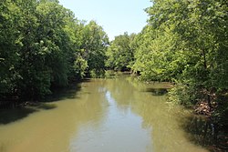
884:
766:
1610:
1345:
1192:
944:
949:
839:
1473:
1350:
1182:
879:
692:
148:
517:
1538:
1513:
1370:
568:
308:
The
Conasauga River is home to more than 90 fish species, including 10 federally listed species of fish and mussels. Among these is the
1015:
1000:
373:
475:
722:
592:
615:
71:
1137:
1508:
1375:
298:
1569:
305:. The preserve covers over 95,000 acres (380 km) and contains approximately 15 miles (24 km) of the Conasauga.
1636:
294:
1574:
410:
328:, with rainbows up to 20 inches (510 mm) and browns to 9 pounds (4.1 kg). The managed land is populated by
497:
1425:
1305:
451:
25:
1275:
819:
1666:
1295:
1202:
1187:
438:
U.S. Geological Survey. Calhoun North quadrangle, GA. 1:24,000. 7.5 Minute Series. Washington D.C.: USGS, 1982.
357:
302:
737:
1330:
1300:
1280:
1265:
1080:
894:
1548:
1420:
1415:
1360:
1310:
1167:
1050:
1030:
979:
899:
429:
U.S. Geological Survey. Dyer Gap quadrangle, GA. 1:24,000. 7.5 Minute Series. Washington D.C.: USGS, 1988.
290:
286:
282:
278:
1600:
1468:
1463:
1105:
1010:
829:
258:
1483:
1395:
1285:
1260:
790:
223:
574:. Athens: Georgia Ecological Services, U.S. Fish and Wildlife Service. December 2009. Archived from
1595:
1380:
1365:
1227:
1157:
1095:
834:
405:
337:
543:
1518:
1478:
1242:
1132:
964:
313:
274:
575:
1448:
1340:
1152:
909:
718:
688:
682:
663:
369:
329:
251:
57:
250:
water on public land in
Georgia. It is the only river in Tennessee that is not a part of the
1605:
1528:
1217:
959:
655:
227:
122:
1503:
1453:
1385:
1320:
1290:
1110:
1005:
849:
844:
599:
504:
483:
455:
353:
1579:
1498:
1488:
1458:
1400:
1325:
1232:
1142:
1035:
995:
969:
954:
939:
924:
914:
874:
814:
623:
235:
1625:
1564:
1493:
1237:
1162:
1147:
1127:
1090:
1085:
1045:
934:
929:
904:
824:
804:
321:
447:
U.S. Geological Survey. National
Hydrography Dataset high-resolution flowline data.
1533:
1410:
1390:
1355:
1315:
1177:
1060:
1040:
1020:
919:
864:
809:
758:
37:
1270:
1252:
1222:
1172:
1100:
1070:
1065:
1055:
1025:
869:
859:
392:
333:
325:
231:
134:
117:
1405:
1335:
1075:
163:
150:
86:
73:
219:
738:
U.S. Geological Survey
Geographic Names Information System: Conasauga River
667:
593:"Study finds high levels of stain-resistance ingredient in Conasauga River"
273:
At the core of the
Conasauga watershed is the 35,268-acre (142.72 km)
226:. The Conasauga River is 93 miles (150 km) long and drains into the
448:
309:
262:
709:
659:
356:
is used for carpet production. The river has been contaminated with
247:
215:
762:
257:
The only road access to the
Conasauga is found via Old GA 2,
352:
Up to one-third of the summer flow taken in the vicinity of
476:"Conasauga River Watershed Ecosystem Restoration Project"
376:, Conasauga River has also been known historically as:
1588:
1557:
1434:
1251:
1119:
988:
797:
197:
189:
179:
140:
128:
116:
102:
63:
53:
44:
18:
605:. (February 10, 2008). Accessed October 26, 2008.
563:
561:
395:now is the name of a tributary of the Conasauga.
684:Native American Placenames of the United States
711:Georgia Place-Names: Their History and Origins
774:
687:. University of Oklahoma Press. p. 117.
8:
753:The Conasauga River - The Nature Conservancy
470:
468:
466:
464:
781:
767:
759:
36:
1657:Bodies of water of Polk County, Tennessee
507:Gorp.com, Great Outdoor Recreation Pages.
246:The Conasauga River is the most westerly
717:. Macon, GA: Winship Press. p. 49.
422:
368:"Conasauga" is a name derived from the
522:Natural Resources Conservation Service
360:used to make carpets stain-resistant.
15:
482:. USDA Forest Service. Archived from
480:Chattahoochee-Oconee National Forests
7:
569:"Conasauga River Watershed Planning"
1662:Rivers of Whitfield County, Georgia
374:Geographic Names Information System
201:772 sq mi (2,000 km)
755:no reference to Conasauga May 2016
546:. U.S. Fish & Wildlife Service
372:meaning "grass". According to the
14:
1444:Alligator (Little Ocmulgee River)
518:"Conasauga River Aquatic Species"
234:and part of the watershed of the
1652:Rivers of Murray County, Georgia
1647:Rivers of Gilmer County, Georgia
1642:Rivers of Fannin County, Georgia
1524:Sweetwater (Chattahoochee River)
1193:Little Ogeechee (Hancock County)
524:. U.S. Department of Agriculture
297:manages the area as part of the
265:is allowed all along the river.
24:
1351:Little Satilla (Atlantic Ocean)
1346:Little Ogechee (Chatham County)
616:"The Chemical in The Conasauga"
1632:Rivers of Georgia (U.S. state)
1198:Little Satilla (Satilla River)
207:River in Tennessee and Georgia
142: • coordinates
65: • coordinates
1:
299:Chattahoochee National Forest
45:Physical characteristics
890:Little (Withlacoochee River)
603:Chattanooga Times Free Press
295:United States Forest Service
218:that runs through southeast
181: • elevation
104: • elevation
708:Krakow, Kenneth K. (1975).
620:Georgia Public Broadcasting
411:List of rivers of Tennessee
130: • location
30:View of the Conasauga River
1683:
1371:North River (Darien River)
591:Fuchs, Erin and Pam Sohn:
1213:New (Withlacoochee River)
1208:New (Chattahoochee River)
845:Chattooga (Tugaloo River)
789:Significant waterways of
458:, accessed April 27, 2011
112:
108:~ 2,400 feet (730 m)
49:
35:
23:
1570:Brunswick–Altamaha Canal
1138:Black (Okefenokee Swamp)
681:Bright, William (2004).
358:perfluorinated compounds
303:Cherokee National Forest
289:counties in Georgia and
1575:Savannah–Ogeechee Canal
1544:Walnut (Ocmulgee River)
1376:North (St. Marys River)
885:Little (Savannah River)
840:Chattooga (Coosa River)
340:, and smaller animals.
185:~ 620 feet (190 m)
1611:List of Georgia rivers
945:South (Ocmulgee River)
648:Environ. Toxicol. Chem
344:Environmental problems
193:93 miles (150 km)
1601:Intracoastal Waterway
1183:Little (Etowah River)
880:Little (Oconee River)
622:. n.d. Archived from
230:, a tributary of the
1539:Walnut (South River)
1514:Spring (Flint River)
581:on 14 December 2018.
544:"Conasauga logperch"
1637:Rivers of Tennessee
498:The Conasauga River
486:on 5 February 2007.
406:Laurel Fork Railway
269:Natural information
164:34.5435°N 84.9027°W
160: /
87:34.8657°N 84.5921°W
83: /
1188:Little Ochlockonee
1081:Richard B. Russell
626:on 6 November 2009
598:2008-10-06 at the
503:2010-05-16 at the
454:2016-06-30 at the
386:Conne-san-ga River
314:Conasauga logperch
293:in Tennessee. The
275:Cohutta Wilderness
1619:
1618:
1031:George W. Andrews
895:Little Tallapoosa
694:978-0-8061-3598-4
370:Cherokee language
330:white-tailed deer
252:Mississippi River
205:
204:
169:34.5435; -84.9027
92:34.8657; -84.5921
58:Cohutta Mountains
1674:
1606:Okefenokee Swamp
1549:Williamson Swamp
1106:Walter F. George
900:Little Tennessee
783:
776:
769:
760:
740:
735:
729:
728:
716:
705:
699:
698:
678:
672:
671:
660:10.1897/07-659.1
642:
636:
635:
633:
631:
612:
606:
589:
583:
582:
580:
573:
565:
556:
555:
553:
551:
540:
534:
533:
531:
529:
514:
508:
494:
488:
487:
472:
459:
449:The National Map
445:
439:
436:
430:
427:
383:Connesauga River
380:Connasauga River
318:Percina jenkinsi
228:Oostanaula River
175:
174:
172:
171:
170:
165:
161:
158:
157:
156:
153:
123:Oostanaula River
105:
98:
97:
95:
94:
93:
88:
84:
81:
80:
79:
76:
66:
40:
28:
16:
1682:
1681:
1677:
1676:
1675:
1673:
1672:
1671:
1667:ACT River Basin
1622:
1621:
1620:
1615:
1584:
1553:
1469:Ichawaynochaway
1436:
1430:
1247:
1121:
1115:
984:
793:
787:
749:
744:
743:
736:
732:
725:
714:
707:
706:
702:
695:
680:
679:
675:
644:
643:
639:
629:
627:
614:
613:
609:
600:Wayback Machine
590:
586:
578:
571:
567:
566:
559:
549:
547:
542:
541:
537:
527:
525:
516:
515:
511:
505:Wayback Machine
495:
491:
474:
473:
462:
456:Wayback Machine
446:
442:
437:
433:
428:
424:
419:
402:
366:
354:Dalton, Georgia
346:
271:
244:
212:Conasauga River
208:
182:
168:
166:
162:
159:
154:
151:
149:
147:
146:
143:
131:
103:
91:
89:
85:
82:
77:
74:
72:
70:
69:
64:
31:
19:Conasauga River
12:
11:
5:
1680:
1678:
1670:
1669:
1664:
1659:
1654:
1649:
1644:
1639:
1634:
1624:
1623:
1617:
1616:
1614:
1613:
1608:
1603:
1598:
1592:
1590:
1586:
1585:
1583:
1582:
1580:Suwannee Canal
1577:
1572:
1567:
1561:
1559:
1555:
1554:
1552:
1551:
1546:
1541:
1536:
1531:
1526:
1521:
1516:
1511:
1506:
1501:
1496:
1491:
1486:
1484:Little Satilla
1481:
1476:
1471:
1466:
1461:
1456:
1451:
1446:
1440:
1438:
1432:
1431:
1429:
1428:
1423:
1418:
1413:
1408:
1403:
1398:
1393:
1388:
1383:
1378:
1373:
1368:
1363:
1358:
1353:
1348:
1343:
1338:
1333:
1328:
1323:
1318:
1313:
1308:
1303:
1298:
1293:
1288:
1283:
1278:
1273:
1268:
1263:
1257:
1255:
1249:
1248:
1246:
1245:
1240:
1235:
1230:
1225:
1220:
1215:
1210:
1205:
1203:Mulberry River
1200:
1195:
1190:
1185:
1180:
1175:
1170:
1165:
1160:
1155:
1150:
1145:
1140:
1135:
1130:
1124:
1122:
1120:Smaller rivers
1117:
1116:
1114:
1113:
1108:
1103:
1098:
1096:Strom Thurmond
1093:
1088:
1083:
1078:
1073:
1068:
1063:
1058:
1053:
1048:
1043:
1038:
1033:
1028:
1023:
1018:
1013:
1008:
1003:
998:
992:
990:
986:
985:
983:
982:
977:
972:
967:
962:
957:
952:
947:
942:
937:
932:
927:
925:Ogeechee River
922:
917:
912:
907:
902:
897:
892:
887:
882:
877:
872:
867:
862:
857:
852:
847:
842:
837:
832:
827:
822:
817:
812:
807:
801:
799:
795:
794:
788:
786:
785:
778:
771:
763:
757:
756:
748:
747:External links
745:
742:
741:
730:
723:
700:
693:
673:
654:(10): 2011–8.
637:
607:
584:
557:
535:
509:
489:
460:
440:
431:
421:
420:
418:
415:
414:
413:
408:
401:
398:
397:
396:
390:
387:
384:
381:
365:
362:
345:
342:
270:
267:
243:
240:
236:Gulf of Mexico
222:and northwest
206:
203:
202:
199:
195:
194:
191:
187:
186:
183:
180:
177:
176:
144:
141:
138:
137:
132:
129:
126:
125:
120:
114:
113:
110:
109:
106:
100:
99:
67:
61:
60:
55:
51:
50:
47:
46:
42:
41:
33:
32:
29:
21:
20:
13:
10:
9:
6:
4:
3:
2:
1679:
1668:
1665:
1663:
1660:
1658:
1655:
1653:
1650:
1648:
1645:
1643:
1640:
1638:
1635:
1633:
1630:
1629:
1627:
1612:
1609:
1607:
1604:
1602:
1599:
1597:
1594:
1593:
1591:
1587:
1581:
1578:
1576:
1573:
1571:
1568:
1566:
1565:Augusta Canal
1563:
1562:
1560:
1556:
1550:
1547:
1545:
1542:
1540:
1537:
1535:
1532:
1530:
1527:
1525:
1522:
1520:
1517:
1515:
1512:
1510:
1509:Rocky Comfort
1507:
1505:
1502:
1500:
1497:
1495:
1492:
1490:
1487:
1485:
1482:
1480:
1477:
1475:
1472:
1470:
1467:
1465:
1462:
1460:
1457:
1455:
1452:
1450:
1447:
1445:
1442:
1441:
1439:
1433:
1427:
1424:
1422:
1419:
1417:
1414:
1412:
1409:
1407:
1404:
1402:
1399:
1397:
1394:
1392:
1389:
1387:
1384:
1382:
1381:North Newport
1379:
1377:
1374:
1372:
1369:
1367:
1364:
1362:
1359:
1357:
1354:
1352:
1349:
1347:
1344:
1342:
1339:
1337:
1334:
1332:
1329:
1327:
1324:
1322:
1319:
1317:
1314:
1312:
1309:
1307:
1304:
1302:
1299:
1297:
1294:
1292:
1289:
1287:
1284:
1282:
1279:
1277:
1274:
1272:
1269:
1267:
1264:
1262:
1259:
1258:
1256:
1254:
1250:
1244:
1241:
1239:
1236:
1234:
1231:
1229:
1228:South Newport
1226:
1224:
1221:
1219:
1216:
1214:
1211:
1209:
1206:
1204:
1201:
1199:
1196:
1194:
1191:
1189:
1186:
1184:
1181:
1179:
1176:
1174:
1171:
1169:
1166:
1164:
1161:
1159:
1156:
1154:
1151:
1149:
1146:
1144:
1141:
1139:
1136:
1134:
1131:
1129:
1126:
1125:
1123:
1118:
1112:
1109:
1107:
1104:
1102:
1099:
1097:
1094:
1092:
1089:
1087:
1084:
1082:
1079:
1077:
1074:
1072:
1069:
1067:
1064:
1062:
1059:
1057:
1054:
1052:
1049:
1047:
1044:
1042:
1039:
1037:
1034:
1032:
1029:
1027:
1024:
1022:
1019:
1017:
1014:
1012:
1009:
1007:
1004:
1002:
999:
997:
994:
993:
991:
987:
981:
978:
976:
975:Withlacoochee
973:
971:
968:
966:
963:
961:
958:
956:
953:
951:
948:
946:
943:
941:
938:
936:
933:
931:
928:
926:
923:
921:
918:
916:
913:
911:
908:
906:
903:
901:
898:
896:
893:
891:
888:
886:
883:
881:
878:
876:
873:
871:
868:
866:
863:
861:
858:
856:
853:
851:
848:
846:
843:
841:
838:
836:
835:Chattahoochee
833:
831:
828:
826:
823:
821:
818:
816:
813:
811:
808:
806:
803:
802:
800:
798:Larger rivers
796:
792:
784:
779:
777:
772:
770:
765:
764:
761:
754:
751:
750:
746:
739:
734:
731:
726:
724:0-915430-00-2
720:
713:
712:
704:
701:
696:
690:
686:
685:
677:
674:
669:
665:
661:
657:
653:
649:
641:
638:
625:
621:
617:
611:
608:
604:
601:
597:
594:
588:
585:
577:
570:
564:
562:
558:
545:
539:
536:
523:
519:
513:
510:
506:
502:
499:
493:
490:
485:
481:
477:
471:
469:
467:
465:
461:
457:
453:
450:
444:
441:
435:
432:
426:
423:
416:
412:
409:
407:
404:
403:
399:
394:
391:
388:
385:
382:
379:
378:
377:
375:
371:
363:
361:
359:
355:
350:
343:
341:
339:
335:
331:
327:
323:
322:rainbow trout
319:
315:
312:, endangered
311:
306:
304:
300:
296:
292:
288:
284:
280:
277:, located in
276:
268:
266:
264:
260:
255:
253:
249:
241:
239:
237:
233:
229:
225:
221:
217:
213:
200:
196:
192:
188:
184:
178:
173:
145:
139:
136:
133:
127:
124:
121:
119:
115:
111:
107:
101:
96:
68:
62:
59:
56:
52:
48:
43:
39:
34:
27:
22:
17:
1519:Suwannoochee
1479:Kinchafoonee
1253:Tidal rivers
1243:Willacoochee
1133:Alapahoochee
965:Toccoa/Ocoee
854:
733:
710:
703:
683:
676:
651:
647:
640:
628:. Retrieved
624:the original
619:
610:
602:
587:
576:the original
548:. Retrieved
538:
526:. Retrieved
521:
512:
492:
484:the original
479:
443:
434:
425:
367:
351:
347:
317:
307:
272:
256:
245:
211:
209:
1449:Big Satilla
1341:Laurel View
1153:Coosawattee
910:Ochlockonee
550:22 February
528:22 February
393:Jacks River
389:Slave River
338:black bears
326:brown trout
291:Polk County
254:watershed.
232:Coosa River
167: /
135:Calhoun, GA
90: /
1626:Categories
1529:Tobesofkee
1435:Creeks and
1426:Wilmington
1306:Cumberland
1218:Oostanaula
1111:West Point
1006:Blackshear
1001:Banks Lake
960:Tallapoosa
630:4 December
417:References
198:Basin size
155:84°54′10″W
152:34°32′37″N
78:84°35′32″W
75:34°51′57″N
1596:Grand Bay
1504:Peachtree
1454:Brasstown
1386:Odingsell
1321:Frederica
1291:Chestatee
1276:Brunswick
1036:Goat Rock
996:Allatoona
950:St. Marys
855:Conasauga
850:Canoochee
820:Apalachee
220:Tennessee
1589:See also
1499:Okapilco
1489:Muckalee
1459:Ebenezer
1401:Skidaway
1326:Halfmoon
1296:Crescent
1233:Tallulah
1143:Cartecay
1091:Sinclair
1086:Seminole
1046:Hartwell
970:Towaliga
955:Suwannee
940:Savannah
915:Ocmulgee
875:Hiwassee
815:Altamaha
668:18419175
596:Archived
501:Archived
452:Archived
400:See also
242:Location
1494:Noonday
1437:streams
1331:Hampton
1301:Crooked
1281:Buffalo
1266:Belfast
1238:Tugaloo
1163:Ellijay
1148:Coleman
1128:Alabaha
1061:Nottely
1051:Jackson
1041:Harding
1021:Chatuge
1016:Carters
935:Satilla
930:Ohoopee
905:Nottely
825:Aucilla
805:Alapaha
791:Georgia
496:(2011)
332:, wild
310:endemic
263:camping
224:Georgia
1558:Canals
1534:Toccoa
1474:Kettle
1464:Euchee
1421:Vernon
1416:Turtle
1411:Tivoli
1391:Sapelo
1361:Medway
1356:Mackay
1316:Duplin
1311:Darien
1178:Jerico
1168:Hudson
1101:Tugalo
1071:Oliver
1066:Oconee
1056:Lanier
1026:Chehaw
1011:Burton
980:Yellow
920:Oconee
865:Etowah
810:Alcovy
721:
691:
666:
287:Murray
285:, and
283:Gilmer
279:Fannin
190:Length
54:Source
1271:Broro
1223:Soque
1173:Jacks
1076:Rabun
989:Lakes
870:Flint
860:Coosa
830:Broad
715:(PDF)
579:(PDF)
572:(PDF)
248:trout
216:river
214:is a
118:Mouth
1406:Sope
1396:Shad
1336:Herb
1286:Bull
1261:Bear
719:ISBN
689:ISBN
664:PMID
632:2009
552:2023
530:2023
364:Name
334:hogs
324:and
301:and
259:GA 2
210:The
1366:Mud
1158:Dog
656:doi
1628::
662:.
652:27
650:.
618:.
560:^
520:.
478:.
463:^
336:,
281:,
782:e
775:t
768:v
727:.
697:.
670:.
658::
634:.
554:.
532:.
316:(
Text is available under the Creative Commons Attribution-ShareAlike License. Additional terms may apply.