342:. The heights are an ice-filled crater rising to 2,000 metres (6,600 ft) high that dominates the south part of Coulman Island and marks the island's summita. Named by NZGSAE, 1958-59, for Captain William M. Hawkes, United States Navy, who took a leading part in early air operations from Williams Field near McMurdo Station, including long range photo reconnaissance and supply flights, and the first air landing at the South Pole. He was commander of one of the two planes which made the historic first flight from Christchurch to McMurdo Sound on Dec. 17, 1955. His air photos proved of great value to two NZGSAE parties to this part of Victoria Land.
40:
275:
27:
47:
709:
675:
265:
and is the largest colony of this species in the world. However, scientists speculate that this colony could hold more birds than what they have estimated. More than 26,000 chicks have been counted during the 2018-2019 breeding season indicating that the number of adults ranged from 30,000 to 35,000
510:
which in
February 1965 was the first vessel to navigate the strait, and is also in conjunction with the significant presence of the two large glacier tongues. The name was proposed by M.R.J. Ford, New Zealand surveyor who was aboard the Glacier in February 1965.
266:
breeding pairs. The sheer numbers of penguins on the island had also led scientists to think that there have been potentially larger emperor penguin super-colonies that may have existed in the past before being wiped out during the last ice age.
506:. A north-south trending strait off the coast of Victoria Land in the western Ross Sea, situated between Coulman Island on the east and Cape Jones, Borchgrevink Glacier Tongue and Mariner Glacier Tongue on the west. The name honors the USS
298:
to the southwest of the island. Glacier Strait separates the island from the mainland. Hawkes
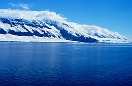
Heights dominate the south of the island. Capes on the east side are, from north to south, Cape Wadworth, Cape Main and Cape Anne.
713:
679:
430:. A small cape situated 5 nautical miles (9.3 km; 5.8 mi) north of Cape Anne, along the east side of Coulman Island. Named by NZ-APC in 1966 for Brian Main, scientific technician at Hallett Station, 1962-63.
386:. The northern extremity of Coulman Island. Discovered Jan. 17, 1841 by Sir James Clark Ross who named it in compliment to his wife's uncle, Robert John Coulman, Esq., of Wadworth Hall, Doncaster.
221:) is an island 18 nautical miles (33 km; 21 mi) long and 8 nautical miles (15 km; 9.2 mi) wide, lying 9 nautical miles (17 km; 10 mi) southeast of
520:
762:
683:
468:. Cape which marks the southeast extremity of Coulman Island. Discovered in January 1841 by Sir James Clark Ross and named by him for his wife.
564:
732:
39:
742:
737:
747:
717:
88:
752:
478:
440:
402:
358:
314:
193:
757:
166:
246:
287:
261:
The island is currently recognized as an important bird area because it holds a huge super-colony of
556:
274:
560:
283:
230:
690:
295:
291:
262:
242:
726:
351:
657:
222:
76:
493:
480:
455:
442:
417:
404:
373:
360:
329:
316:
208:
195:
103:
90:
395:
26:
226:
253:
called the Hawkes
Heights can be found on the south end of the island.
250:
249:. A 5 km (3.1 mi) wide and 700 m (2,300 ft) deep
273:
245:
that form part of the
Hallett Volcanic Province of the
282:
Coulman Island is in the Ross Sea to the southeast of
665:(2 ed.), United States Board on Geographic Names
233:
who named it for his father-in-law, Thomas
Coulman.
177:
172:
159:
151:
143:
135:
127:
119:
82:
72:
67:
579:
241:The island is composed of several overlapping
225:, Victoria Land, Antarctica, in the western
8:
19:
25:
18:
521:List of Antarctic islands south of 60° S
695:, USGS: United States Geological Survey
684:United States Board on Geographic Names
639:
627:
615:
603:
591:
538:
531:
46:
16:Island in Ross Dependency, Antarctica
7:
229:. It was discovered in 1841 by Sir
716:from websites or documents of the
682:from websites or documents of the
14:
659:Geographic Names of the Antarctic
286:, and east of the ice tongues of
123:319 km (123 sq mi)
712: This article incorporates
707:
678: This article incorporates
673:
45:
38:
718:United States Geological Survey
763:Shield volcanoes of Antarctica
656:Alberts, Fred G., ed. (1995),
1:
553:Encyclopedia of the Antarctic
278:Coulman Island to east of map
147:6,562 ft (2000.1 m)
131:33.3 km (20.69 mi)
779:
733:Volcanoes of Victoria Land
551:Riffenburgh, Beau (2007).
393:
349:
139:14.8 km (9.2 mi)
257:Important Bird Area (IBA)
164:
33:
24:
743:Miocene shield volcanoes
738:Islands of Victoria Land
167:Antarctic Treaty System
165:Administered under the
748:Calderas of Antarctica
714:public domain material
680:public domain material
279:
247:McMurdo Volcanic Group
144:Highest elevation
59:Location in Antarctica
277:
557:Taylor & Francis
294:, which extend into
288:Borchgrevink Glacier
594:, pp. 319–320.
580:Coulman Island USGS
490: /
452: /
414: /
370: /
326: /
205: /
100: /
21:
753:Borchgrevink Coast
494:73.417°S 169.400°E
456:73.617°S 169.850°E
418:73.550°S 169.900°E
374:73.317°S 169.783°E
330:73.533°S 169.700°E
280:
209:73.467°S 169.750°E
152:Highest point
104:73.483°S 169.750°E
566:978-0-415-97024-2
284:Daniell Peninsula
185:
184:
770:
758:Volcanic islands
711:
710:
702:
701:
700:
677:
676:
672:
671:
670:
664:
643:
637:
631:
625:
619:
613:
607:
601:
595:
589:
583:
577:
571:
570:
548:
542:
536:
505:
504:
502:
501:
500:
499:-73.417; 169.400
495:
491:
488:
487:
486:
483:
467:
466:
464:
463:
462:
461:-73.617; 169.850
457:
453:
450:
449:
448:
445:
429:
428:
426:
425:
424:
423:-73.550; 169.900
419:
415:
412:
411:
410:
407:
385:
384:
382:
381:
380:
379:-73.317; 169.783
375:
371:
368:
367:
366:
363:
341:
340:
338:
337:
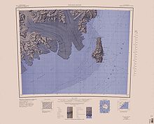
336:
335:-73.533; 169.700
331:
327:
324:
323:
322:
319:
263:emperor penguins
243:shield volcanoes
231:James Clark Ross
220:
219:
217:
216:
215:
214:-73.467; 169.750
210:
206:
203:
202:
201:
198:
115:
114:
112:
111:
110:
109:-73.483; 169.750
105:
101:
98:
97:
96:
93:
49:
48:
42:
29:
22:
778:
777:
773:
772:
771:
769:
768:
767:
723:
722:
708:
705:
698:
696:
689:
674:
668:
666:
662:
655:
651:
646:
638:
634:
626:
622:
614:
610:
602:
598:
590:
586:
578:
574:
567:
559:. p. 639.
555:. Vol. 1.
550:
549:
545:
537:
533:
529:
517:
498:
496:
492:
489:
484:
481:
479:
477:
476:
474:
460:
458:
454:
451:
446:
443:
441:
439:
438:
436:
422:
420:
416:
413:
408:
405:
403:
401:
400:
398:
392:
378:
376:
372:
369:
364:
361:
359:
357:
356:
354:
348:
334:
332:
328:
325:
320:
317:
315:
313:
312:
310:
305:
296:Lady Newnes Bay
292:Mariner Glacier
272:
259:
239:
213:
211:
207:
204:
199:
196:
194:
192:
191:
108:
106:
102:
99:
94:
91:
89:
87:
86:
63:
62:
61:
60:
57:
56:
55:
54:
50:
17:
12:
11:
5:
776:
774:
766:
765:
760:
755:
750:
745:
740:
735:
725:
724:
704:
703:
692:Coulman Island
687:
652:
650:
647:
645:
644:
642:, p. 280.
632:
620:
618:, p. 456.
608:
606:, p. 790.
596:
584:
572:
565:
543:
541:, p. 156.
530:
528:
525:
524:
523:
516:
513:
473:
472:Glacier Strait
470:
435:
432:
394:Main article:
391:
388:
350:Main article:
347:
344:
309:
308:Hawkes Heights
306:
304:
301:
271:
268:
258:
255:
238:
235:
188:Coulman Island
183:
182:
179:
175:
174:
170:
169:
162:
161:
160:Administration
157:
156:
155:Hawkes Heights
153:
149:
148:
145:
141:
140:
137:
133:
132:
129:
125:
124:
121:
117:
116:
84:
80:
79:
74:
70:
69:
65:
64:
58:
53:Coulman Island
52:
51:
44:
43:
37:
36:
35:
34:
31:
30:
20:Coulman Island
15:
13:
10:
9:
6:
4:
3:
2:
775:
764:
761:
759:
756:
754:
751:
749:
746:
744:
741:
739:
736:
734:
731:
730:
728:
721:
719:
715:
694:
693:
688:
685:
681:
661:
660:
654:
653:
648:
641:
636:
633:
630:, p. 22.
629:
624:
621:
617:
612:
609:
605:
600:
597:
593:
588:
585:
581:
576:
573:
568:
562:
558:
554:
547:
544:
540:
535:
532:
526:
522:
519:
518:
514:
512:
509:
503:
471:
469:
465:
433:
431:
427:
397:
389:
387:
383:
353:
352:Cape Wadworth
346:Cape Wadworth
345:
343:
339:
307:
302:
300:
297:
293:
289:
285:
276:
269:
267:
264:
256:
254:
252:
248:
244:
236:
234:
232:
228:
224:
218:
189:
180:
176:
171:
168:
163:
158:
154:
150:
146:
142:
138:
134:
130:
126:
122:
118:
113:
85:
81:
78:
75:
71:
66:
41:
32:
28:
23:
706:
697:, retrieved
691:
667:, retrieved
658:
640:Alberts 1995
635:
628:Alberts 1995
623:
616:Alberts 1995
611:
604:Alberts 1995
599:
592:Alberts 1995
587:
575:
552:
546:
539:Alberts 1995
534:
507:
475:
437:
399:
355:
311:
281:
260:
240:
187:
186:
173:Demographics
497: /
459: /
421: /
377: /
333: /
212: /
181:Uninhabited
107: /
83:Coordinates
727:Categories
699:2024-01-24
669:2024-01-21
527:References
223:Cape Jones
178:Population
77:Antarctica
434:Cape Anne
396:Cape Main
390:Cape Main
270:Geography
68:Geography
515:See also
485:169°24′E
447:169°51′E
409:169°54′E
365:169°47′E
321:169°42′E
303:Features
227:Ross Sea
200:169°45′E
95:169°45′E
73:Location
649:Sources
508:Glacier
482:73°25′S
444:73°37′S
406:73°33′S
362:73°19′S
318:73°32′S
251:caldera
237:Geology
197:73°28′S
92:73°29′S
563:
128:Length
663:(PDF)
136:Width
561:ISBN
290:and
120:Area
729::
720:.
686:.
582:.
569:.
190:(
Text is available under the Creative Commons Attribution-ShareAlike License. Additional terms may apply.