33:
183:
191:
837:. The seaward end of a ridge from the Mountaineer Range, situated at the confluence of the Icebreaker and Fitzgerald Glaciers. Mapped by the USGS from surveys and United States Navy air photos 1960-64. Named by the US-ACAN for Agustive A. Hermes, Jr., United States Navy, aviation structural mechanic at Williams Field, McMurdo Sound, on United States Navy OpDFrz, 1967 and 1968.
761:. A prominent, rocky, digit-like point that juts eastward into Lady Newnes Bay toward the floating glacier tongue of the Parker Glacier. Mapped by the USGS from surveys and United States Navy air photos, 1960-64. Named by US-ACAN for Commander H.R. Andrus, logistics officer on the staff of the Commander, United States Naval Support Force, Antarctica, 1962-66.
40:
466:. A tributary glacier which drains the northwest slopes of Mount Monteagle and flows north into the upper part of Icebreaker Glacier. Mapped by USGS from surveys and United States Navy air photos, 1960-64. Named by US-ACAN for Russell H. Finley, aviation boatswain's mate with Squadron VX-6 during United States Navy OpDFrz, 1966, 1967 and 1968.
1383:
1333:
875:. A cape forming the seaward end of the rocky west wall of Wylde Glacier where the glacier enters Lady Newnes Bay, Ross Sea. Mapped by USGS from surveys and United States Navy air photos, 1960-64. Named by US-ACAN for Geoffrey A. King, ionospheric and geomagnetic scientist at Hallett Station, 1958.
202:
extends into the Ross Sea. Further east, past Andrus Point, the Parker
Glacier enters the bay from the north. East of this, past Greene Point, the Oakley Glacier enters from the north, beside the Icebreaker Glacier and the Fitzgerald Glacier, which form a common tongue. The Finley Glacier and Dunn
335:
to merge with the floating tongue from the
Icebreaker Glacier at Lady Newnes Bay. Mapped by USGS from surveys and United States Navy air photos, 1960-64. Named by US-ACAN for Lieutenant Commander Donald C. Oakley, United States Navy, Protestant chaplain with the winter party at McMurdo Station,
799:. An ice-covered point 7 nautical miles (13 km; 8.1 mi) northeast of Andrus Point in Lady Newnes Bay. Mapped by USGS from surveys and United States Navy air photos, 1960-64. Named by US-ACAN after Stanley W. Greene, biologist at McMurdo Station, 1964-65.
673:. A short, fairly smooth glacier in the east extremity of Mountaineer Range, draining southeast to the coast between Gauntlet Ridge and Index Point. So named in 1966 by NZ-APC, presumably as descriptive of the emerging or youthful development of the feature.
1027:. A flat-topped, mainly ice-covered ridge, or peninsula, which separates the mouths of Nascent and Ridgeway Glaciers where they discharge into Lady Newnes Bay. The name suggests the appearance of the feature in plan and was applied by NZ-APC in 1966.
913:. A rounded, ice-filled cove in Lady Newnes Bay, situated between the mouths of Wylde and Suter Glaciers. The shape of the cove and the points that encompass it are nearly symmetrical suggesting calipers; hence the name applied by NZ-APC in 1966.
210:
to the north, then east of
Caliper Cove the Suter Glacier enters from the north. East of Spatulate Ridge and Apostrophe Island the Ridgeway Glacier enters from the north, then east of Gauntlet Ridge the Nascent Glacier enters from the north. The
635:. A short glacier in the east part of Mountaineer Range, draining southeast between Spatulate Ridge and Gauntlet Ridge into Lady Newnes Bay. Named by NZ-APC in 1966 for Norman Ridgeway, senior scientist at Hallett Station, 1963-64.
1387:
1337:
597:. A short glacier in the Mountaineer Range, draining southeast into Lady Newnes Bay just south of Spatulate Ridge. Named by NZ-APC in 1966 for Douglas Suter, senior New Zealand scientist at Hallett Station, 1962-63.
951:. An ice-covered ridge in the Mountaineer Range which extends southeast between Suter Glacier and Ridgeway Glacier to the coast. The name is descriptive of the shape and was applied in 1966 by the NZ-APC.
382:(NZGSAE), 1958-59, as a tribute to the work of the complements of United States Navy, and United States Coast Guard icebreakers in Antarctic exploration, in supporting scientists and in aiding other ships.
508:
and flows north to
Icebreaker Glacier. Mapped by USGS from surveys and United States Navy air photos, 1960-64. Named by US-ACAN for Robert Dunn, United States Navy, commissaryman, McMurdo Station, 1967.
989:. Small ice-covered island lying close off Spatulate Ridge in Lady Newnes Bay. The name is descriptive of the appearance of the island in plan and was given by NZ-APC in 1966.
379:
723:
at the terminus of
Aviator Glacier. Sighted in February 1841 by Sir James Clark Ross and named by him for Lieutenant (later Commander) John Sibbald of the Erebus.
425:
32:
1341:
290:
424:. At the mouth it coalesces with the Icebreaker Glacier before debouching on Lady Newnes Bay. Explored by NZGSAE, 1958-59, and named by
75:
374:. A large valley glacier 10 nautical miles (19 km; 12 mi) northeast of Mount Monteagle that flows southeast from the
1391:
548:
421:
286:
285:, and flows south to Lady Newnes Bay where it terminates in a floating glacier tongue adjacent to Andrus Point. Mapped by the
1406:
1411:
293:(US-ACAN) for Anthony G.H. Parker, biologist at Hallett Station in 1963-64, and McMurdo Station, 1964-65 and 1966-67.
999:
961:
923:
885:
847:
809:
771:
733:
691:
645:
607:
569:
519:
476:
438:
392:
346:
303:
253:
114:
163:
420:. A prominent valley glacier draining to Lady Newnes Bay from the ice cascades on the south and west slopes of
555:
and Cape King into Lady Newnes Bay. Named in 1966 by the NZ-APC for
Leonard Wylde, scientific officer at
378:
to Lady Newnes Bay. Below Hermes Point, its flow coalesces with that of
Fitzgerald Glacier. Named by the
719:. A cliffed cape at the southwest margin of Lady Newnes Bay. It marks the southwest extremity of the
224:
167:
182:
190:
720:
375:
281:. A valley glacier in the Mountaineer Range which drains the area just east and northeast of
207:
289:(USGS) from surveys and United States Navy air photos, 1960-64. Named by the United States
1364:
1348:
556:
282:
220:
212:
199:
232:
151:
1400:
552:
171:
147:
61:
1315:
681:
Other features along the shore of the Lady Newnes Bay include, from west to east,
162:
Lady Newnes Bay was discovered by the
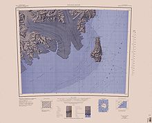
British Antarctic Expedition 1898–1900 (or
142:) is a bay about 60 nautical miles (110 km; 69 mi) long in the western
505:
332:
216:
231:. Both these glaciers extend tongues into the bay to the west and southwest of
228:
1014:
1001:
976:
963:
938:
925:
900:
887:
862:
849:
824:
811:
786:
773:
748:
735:
706:
693:
660:
647:
622:
609:
584:
571:
534:
521:
491:
478:
453:
440:
407:
394:
361:
348:
318:
305:
268:
255:
129:
116:
90:
77:
198:
The most westerly point of the bay is Cape
Sibbald, where the tongue of the
143:
203:
Glacier are tributaries of the
Icebreaker Glacier from the southwest.
504:. A steep tributary glacier which drains the northwest slopes of
243:
From west to east, glaciers entering the Lady Newnes Bay include,
189:
181:
428:(NZ-APC) for E.B. Fitzgerald, deputy leader of the expedition.
331:. A glacier in the Mountaineer Range that descends east from
170:. He named it for Lady Priscilla Newnes, whose husband, Sir
1041:
1039:
1323:(2 ed.), United States Board on Geographic Names
206:
East of Cape King the Wylde Glacier enters from the
67:
57:
21:
380:New Zealand Geological Survey Antarctic Expedition
1057:
68:
1069:
8:
235:, which defines the eastern end of the bay.
426:New Zealand Antarctic Place-Names Committee
18:
1369:, USGS: United States Geological Survey
1353:, USGS: United States Geological Survey
1342:United States Board on Geographic Names
1297:
1285:
1273:
1261:
1249:
1237:
1225:
1213:
1201:
1189:
1177:
1165:
1153:
1141:
1129:
1117:
1105:
1093:
1081:
1045:
1035:
39:
291:Advisory Committee on Antarctic Names
7:
1390:from websites or documents of the
1340:from websites or documents of the
186:West end of bay (southeast of map)
14:
1317:Geographic Names of the Antarctic
1386: This article incorporates
1381:
1336: This article incorporates
1331:
38:
31:
1392:United States Geological Survey
287:United States Geological Survey
146:, extending along the coast of
1314:Alberts, Fred G., ed. (1995),
547:. A glacier situated east of
194:East of bay and Coulman Island
1:
56:
174:, financed the expedition.
16:Bay in the western Ross Sea
1428:
551:, draining south between
164:Southern Cross Expedition
26:
215:enters from the east of
1388:public domain material
1338:public domain material
195:
187:
158:Exploration and naming
1407:Bays of Victoria Land
193:
185:
150:from Cape Sibbald to
1058:Mount Murchison USGS
225:Borchgrevink Glacier
168:Carsten Borchgrevink
1070:Coulman Island USGS
1011: /
973: /
935: /
897: /
859: /
821: /
783: /
745: /
703: /
657: /
619: /
581: /
531: /
488: /
450: /
404: /
358: /
315: /
265: /
126: /
87: /
1412:Borchgrevink Coast
1015:73.417°S 167.583°E
977:73.517°S 167.433°E
939:73.467°S 167.217°E
901:73.567°S 166.933°E
863:73.583°S 166.617°E
825:73.583°S 166.217°E
787:73.817°S 166.150°E
749:73.883°S 165.800°E
707:73.900°S 165.383°E
661:73.367°S 167.617°E
623:73.400°S 167.233°E
585:73.517°S 167.167°E
535:73.533°S 166.700°E
492:73.600°S 165.767°E
454:73.583°S 165.633°E
408:73.550°S 166.250°E
386:Fitzgerald Glacier
362:73.617°S 166.167°E
340:Icebreaker Glacier
319:73.700°S 166.133°E
269:73.783°S 165.550°E
196:
188:
130:73.667°S 167.500°E
91:73.667°S 167.500°E
955:Apostrophe Island
721:Mountaineer Range
376:Mountaineer Range
208:Mountaineer Range
106:
105:
1419:
1385:
1384:
1376:
1375:
1374:
1360:
1359:
1358:
1335:
1334:
1330:
1329:
1328:
1322:
1301:
1295:
1289:
1283:
1277:
1271:
1265:
1259:
1253:
1247:
1241:
1235:
1229:
1223:
1217:
1211:
1205:
1199:
1193:
1187:
1181:
1175:
1169:
1163:
1157:
1151:
1145:
1139:
1133:
1127:
1121:
1115:
1109:
1103:
1097:
1091:
1085:
1079:
1073:
1067:
1061:
1055:
1049:
1043:
1026:
1025:
1023:
1022:
1021:
1020:-73.417; 167.583
1016:
1012:
1009:
1008:
1007:
1004:
988:
987:
985:
984:
983:
982:-73.517; 167.433
978:
974:
971:
970:
969:
966:
950:
949:
947:
946:
945:
944:-73.467; 167.217
940:
936:
933:
932:
931:
928:
912:
911:
909:
908:
907:
906:-73.567; 166.933
902:
898:
895:
894:
893:
890:
874:
873:
871:
870:
869:
868:-73.583; 166.617
864:
860:
857:
856:
855:
852:
836:
835:
833:
832:
831:
830:-73.583; 166.217
826:
822:
819:
818:
817:
814:
798:
797:
795:
794:
793:
792:-73.817; 166.150
788:
784:
781:
780:
779:
776:
760:
759:
757:
756:
755:
754:-73.883; 165.800
750:
746:
743:
742:
741:
738:
718:
717:
715:
714:
713:
712:-73.900; 165.383
708:
704:
701:
700:
699:
696:
672:
671:
669:
668:
667:
666:-73.367; 167.617
662:
658:
655:
654:
653:
650:
634:
633:
631:
630:
629:
628:-73.400; 167.233
624:
620:
617:
616:
615:
612:
601:Ridgeway Glacier
596:
595:
593:
592:
591:
590:-73.517; 167.167
586:
582:
579:
578:
577:
574:
546:
545:
543:
542:
541:
540:-73.533; 166.700
536:
532:
529:
528:
527:
524:
503:
502:
500:
499:
498:
497:-73.600; 165.767
493:
489:
486:
485:
484:
481:
465:
464:
462:
461:
460:
459:-73.583; 165.633
455:
451:
448:
447:
446:
443:
419:
418:
416:
415:
414:
413:-73.550; 166.250
409:
405:
402:
401:
400:
397:
373:
372:
370:
369:
368:
367:-73.617; 166.167
363:
359:
356:
355:
354:
351:
330:
329:
327:
326:
325:
324:-73.700; 166.133
320:
316:
313:
312:
311:
308:
280:
279:
277:
276:
275:
274:-73.783; 165.550
270:
266:
263:
262:
261:
258:
141:
140:
138:
137:
136:
135:-73.667; 167.500
131:
127:
124:
123:
122:
119:
102:
101:
99:
98:
97:
96:-73.667; 167.500
92:
88:
85:
84:
83:
80:
70:
42:
41:
35:
19:
1427:
1426:
1422:
1421:
1420:
1418:
1417:
1416:
1397:
1396:
1382:
1379:
1372:
1370:
1366:Mount Murchison
1363:
1356:
1354:
1347:
1332:
1326:
1324:
1320:
1313:
1309:
1304:
1296:
1292:
1284:
1280:
1272:
1268:
1260:
1256:
1248:
1244:
1236:
1232:
1224:
1220:
1212:
1208:
1200:
1196:
1188:
1184:
1176:
1172:
1164:
1160:
1152:
1148:
1140:
1136:
1128:
1124:
1116:
1112:
1104:
1100:
1092:
1088:
1080:
1076:
1068:
1064:
1056:
1052:
1044:
1037:
1033:
1019:
1017:
1013:
1010:
1005:
1002:
1000:
998:
997:
995:
981:
979:
975:
972:
967:
964:
962:
960:
959:
957:
943:
941:
937:
934:
929:
926:
924:
922:
921:
919:
917:Spatulate Ridge
905:
903:
899:
896:
891:
888:
886:
884:
883:
881:
867:
865:
861:
858:
853:
850:
848:
846:
845:
843:
829:
827:
823:
820:
815:
812:
810:
808:
807:
805:
791:
789:
785:
782:
777:
774:
772:
770:
769:
767:
753:
751:
747:
744:
739:
736:
734:
732:
731:
729:
711:
709:
705:
702:
697:
694:
692:
690:
689:
687:
679:
665:
663:
659:
656:
651:
648:
646:
644:
643:
641:
639:Nascent Glacier
627:
625:
621:
618:
613:
610:
608:
606:
605:
603:
589:
587:
583:
580:
575:
572:
570:
568:
567:
565:
557:Hallett Station
549:Mount Murchison
539:
537:
533:
530:
525:
522:
520:
518:
517:
515:
496:
494:
490:
487:
482:
479:
477:
475:
474:
472:
458:
456:
452:
449:
444:
441:
439:
437:
436:
434:
422:Mount Murchison
412:
410:
406:
403:
398:
395:
393:
391:
390:
388:
366:
364:
360:
357:
352:
349:
347:
345:
344:
342:
323:
321:
317:
314:
309:
306:
304:
302:
301:
299:
283:Mount Monteagle
273:
271:
267:
264:
259:
256:
254:
252:
251:
249:
241:
227:to the west of
221:Emerging Island
213:Mariner Glacier
200:Aviator Glacier
180:
160:
134:
132:
128:
125:
120:
117:
115:
113:
112:
109:Lady Newnes Bay
95:
93:
89:
86:
81:
78:
76:
74:
73:
53:
52:
51:
50:
49:
48:
47:
46:Lady Newnes Bay
43:
22:Lady Newnes Bay
17:
12:
11:
5:
1425:
1423:
1415:
1414:
1409:
1399:
1398:
1378:
1377:
1361:
1350:Coulman Island
1345:
1310:
1308:
1305:
1303:
1302:
1300:, p. 271.
1290:
1278:
1276:, p. 699.
1266:
1264:, p. 113.
1254:
1252:, p. 392.
1242:
1240:, p. 330.
1230:
1228:, p. 293.
1218:
1206:
1204:, p. 673.
1194:
1192:, p. 517.
1182:
1180:, p. 618.
1170:
1168:, p. 725.
1158:
1156:, p. 826.
1146:
1144:, p. 204.
1134:
1132:, p. 240.
1122:
1120:, p. 242.
1110:
1108:, p. 358.
1098:
1096:, p. 537.
1086:
1084:, p. 557.
1074:
1062:
1050:
1048:, p. 411.
1034:
1032:
1029:
994:
993:Gauntlet Ridge
991:
956:
953:
918:
915:
880:
877:
842:
839:
804:
801:
766:
763:
728:
725:
686:
683:
678:
677:Other features
675:
640:
637:
602:
599:
564:
561:
514:
511:
471:
468:
433:
432:Finley Glacier
430:
387:
384:
341:
338:
298:
297:Oakley Glacier
295:
248:
247:Parker Glacier
245:
240:
237:
233:Coulman Island
179:
176:
159:
156:
152:Coulman Island
104:
103:
71:
65:
64:
59:
55:
54:
45:
44:
37:
36:
30:
29:
28:
27:
24:
23:
15:
13:
10:
9:
6:
4:
3:
2:
1424:
1413:
1410:
1408:
1405:
1404:
1402:
1395:
1393:
1389:
1368:
1367:
1362:
1352:
1351:
1346:
1343:
1339:
1319:
1318:
1312:
1311:
1306:
1299:
1294:
1291:
1288:, p. 24.
1287:
1282:
1279:
1275:
1270:
1267:
1263:
1258:
1255:
1251:
1246:
1243:
1239:
1234:
1231:
1227:
1222:
1219:
1216:, p. 21.
1215:
1210:
1207:
1203:
1198:
1195:
1191:
1186:
1183:
1179:
1174:
1171:
1167:
1162:
1159:
1155:
1150:
1147:
1143:
1138:
1135:
1131:
1126:
1123:
1119:
1114:
1111:
1107:
1102:
1099:
1095:
1090:
1087:
1083:
1078:
1075:
1071:
1066:
1063:
1059:
1054:
1051:
1047:
1042:
1040:
1036:
1030:
1028:
1024:
992:
990:
986:
954:
952:
948:
916:
914:
910:
878:
876:
872:
840:
838:
834:
802:
800:
796:
764:
762:
758:
726:
724:
722:
716:
684:
682:
676:
674:
670:
638:
636:
632:
600:
598:
594:
563:Suter Glacier
562:
560:
558:
554:
553:Dessent Ridge
550:
544:
513:Wylde Glacier
512:
510:
507:
501:
469:
467:
463:
431:
429:
427:
423:
417:
385:
383:
381:
377:
371:
339:
337:
334:
328:
296:
294:
292:
288:
284:
278:
246:
244:
238:
236:
234:
230:
226:
223:, beside the
222:
218:
214:
209:
204:
201:
192:
184:
177:
175:
173:
172:George Newnes
169:
165:
157:
155:
153:
149:
148:Victoria Land
145:
139:
110:
100:
72:
66:
63:
62:Victoria Land
60:
34:
25:
20:
1380:
1371:, retrieved
1365:
1355:, retrieved
1349:
1325:, retrieved
1316:
1298:Alberts 1995
1293:
1286:Alberts 1995
1281:
1274:Alberts 1995
1269:
1262:Alberts 1995
1257:
1250:Alberts 1995
1245:
1238:Alberts 1995
1233:
1226:Alberts 1995
1221:
1214:Alberts 1995
1209:
1202:Alberts 1995
1197:
1190:Alberts 1995
1185:
1178:Alberts 1995
1173:
1166:Alberts 1995
1161:
1154:Alberts 1995
1149:
1142:Alberts 1995
1137:
1130:Alberts 1995
1125:
1118:Alberts 1995
1113:
1106:Alberts 1995
1101:
1094:Alberts 1995
1089:
1082:Alberts 1995
1077:
1065:
1053:
1046:Alberts 1995
996:
958:
920:
882:
879:Caliper Cove
844:
806:
803:Hermes Point
768:
765:Greene Point
730:
727:Andrus Point
688:
685:Cape Sibbald
680:
642:
604:
566:
516:
473:
470:Dunn Glacier
435:
389:
343:
300:
250:
242:
205:
197:
161:
108:
107:
1018: /
980: /
942: /
904: /
866: /
828: /
790: /
752: /
710: /
664: /
626: /
588: /
559:, 1962-63.
538: /
506:Mount Casey
495: /
457: /
411: /
365: /
333:Mount Casey
322: /
272: /
217:Index Point
133: /
94: /
69:Coordinates
1401:Categories
1373:2024-01-25
1357:2024-01-25
1327:2024-01-25
1031:References
229:Cape Jones
841:Cape King
178:Geography
166:) led by
1006:167°35′E
968:167°26′E
930:167°13′E
892:166°56′E
854:166°37′E
816:166°13′E
778:166°09′E
740:165°48′E
698:165°23′E
652:167°37′E
614:167°14′E
576:167°10′E
526:166°42′E
483:165°46′E
445:165°38′E
399:166°15′E
353:166°10′E
310:166°08′E
260:165°33′E
239:Glaciers
144:Ross Sea
121:167°30′E
82:167°30′E
58:Location
1307:Sources
1003:73°25′S
965:73°31′S
927:73°28′S
889:73°34′S
851:73°35′S
813:73°35′S
775:73°49′S
737:73°53′S
695:73°54′S
649:73°22′S
611:73°24′S
573:73°31′S
523:73°32′S
480:73°36′S
442:73°35′S
396:73°33′S
350:73°37′S
307:73°42′S
257:73°47′S
118:73°40′S
79:73°40′S
336:1967.
1321:(PDF)
219:and
1403::
1394:.
1038:^
154:.
1344:.
1072:.
1060:.
111:(
Text is available under the Creative Commons Attribution-ShareAlike License. Additional terms may apply.