1515:
53:
69:
401:
offshore borrow area, pumping it onto the beach and shaping the sand into an approved beach face and dune template in front of the communities of Davis Park, Corneille
Estates, Dunewood, Fair Harbor, Fire Island Pines, Fire Island Summer Club, Lonelyville, Ocean Bay Park, Ocean Beach, Saltaire, and Seaview. Fire Islanders agreed to a significant property tax increase to help pay for the project, which was estimated to cost between $ 23 and $ 25 million, including the cost of
379:
and wooden boardwalks. There are no cars (except for emergency, utility and construction vehicles and a very limited number of private vehicles, which are only allowed through a strict permit process regulated by the
National Park Service). There are no street lights except in the marina area, resulting in fine night time star-gazing. There are, a Brookhaven town public marina, a (seasonally) lifeguarded section of beach and public restrooms and showers.
405:, and was expected to add 1.8 million cubic yards of sand in front of the participating communities. The towns of Brookhaven and Islip, in which the communities are located, issued bonds to pay for the project, backed by the new taxes levied by community Erosion Control Taxing Districts. Fire Island has been named by the American Shore and Beach Preservation Association a winner of its 2009 Best Restored Beach award.
412:, by then nicknamed the "nor' Ida," did substantial damage to the beachfront in Davis Park, carrying away much of the sand of the previous spring's beach renourishment project. New York Governor David A. Paterson asked President Barack Obama to declare a major federal disaster for the counties of Nassau, Queens and Suffolk (including Fire Island) for the severe erosion and damage to the protective barrier beaches.
532:
505:
541:
478:
496:
487:
514:
523:
76:
391:
The origins of Davis Park can be tracked back to the 1940s. It all started with Mr. Davis of Blue Point who owned a tract of land of Fire Island. When he passed away he left some of the land to his sons. One of those sons sold his share of the land to four friends (Lee Coffin, Ed
Sembler, Joe Gerard,
332:
mile (0.80 km) east, and Water Island (a community, not a separate island) is approximately one mile (1.6 km) to the west. Davis Park lies approximately 13.9 miles (22.4 km) from the eastern end of Fire Island at
Moriches Inlet and 16.3 miles (26.2 km) from the western end of Fire
378:
Davis Park has approximately 350 homes (130 in Ocean Ridge and 220 in Davis Park), one general store and grill, one restaurant and one bar. The restaurant and bar are the only ones on Fire Island with a clear view of the bay and the ocean. There is one unpaved road, commonly called the Burma Road,
400:
In the winter and spring of 2009, a beach renourishment project was undertaken on Fire Island, with the cooperation of the
National Park Service, the U.S. Army Corps of Engineers, the towns of Brookhaven and Islip and Fire Island residents. The renourishment program involved dredging sand from an
382:
Davis Park is protected by the all-volunteer Davis Park Fire
Department and by Suffolk County Police. The non-for-profit Davis Park Medical Association owns a house, "Bedside Manor," on the dune in Ocean Ridge, which is rented in season to doctors and nurse practitioners at a below-market rate in
428:
On the oceanside of Davis Park there is a restaurant known as the "Casino Cafe" which is one of the few oceanfront restaurants on the entire island. It has two distinctly separate areas, one area provides sit down dining, and a second area which serves as a bar with food services and music
317:
mile (1.2 km) of beachfront, and is approximately 330 yards (0.30 km) wide at its widest and 190 yards (0.17 km) wide at its narrowest point (dune to bay, excluding ocean beach width). Davis Park is bordered by extensive wilderness areas to both east and west. The
292:
Technically, Davis Park refers to the business and public part of the community on both sides of
Trustees' Walk, in contrast to the sections known as Leja Beach (to the west of Trustees Walk bounding Center Walk to the North and South) and Ocean Ridge (to the east).
374:
To reach Davis Park, one must travel by boat. A ferry (seasonal, mid-March to end of
November) is available which departs from Sandspit Park in Patchogue on the mainland of Long Island and travels approximately for 15–20 minutes across the Great South Bay.
288:
Davis Park is commonly used to refer to three contiguous areas in the hamlet of Davis Park, namely, Davis Park, Leja Beach, and Ocean Ridge. The three areas share services and social life, and are separated from other communities on Fire Island.
383:
exchange for their agreement to provide basic medical services through scheduled office hours and on-call availability. Bedside Manor is equipped with basic medical equipment and supplies. A helipad provides emergency evacuation capability.
421:
Like all Fire Island hamlets, Davis Park's main draw is its beautiful, soft sand ocean beach, and the idyllic nature of a boardwalk based waterfront community which is surrounded by vegetation and wildlife, and undisturbed by
2545:
1408:
425:
There is a single store named “The Harbor Store” near the Davis Park marina. It consists of a general market, a grill and ice cream stand, as well as a wine store.
1022:
285:
Davis Park is a Fire Island beach community which acts as a destination for families and singles alike, who are home owners, renters, boaters, and ferry goers.
2540:
1114:
1061:
1043:
2491:
911:
52:
392:
and Al Brown) who would later go on to build the Davis Park Casino. The first letters of their first names were used to create the name of LEJA Beach.
646:
591:
322:
facility of the
National Park Service (with a small marina, restaurant, campground, nature trail and seasonal tours and activities) is approximately
100:
576:
1401:
2116:
876:
733:
296:
Davis Park is the easternmost private community on Fire Island (formerly, there were other communities to the east that were removed by the
2535:
2346:
2121:
1698:
1525:
1451:
2181:
1573:
567:
223:
2276:
1015:
343:
68:
1394:
2266:
2216:
2156:
1568:
1282:
619:
1678:
1673:
572:
2530:
2211:
1386:
2525:
1008:
866:
301:
279:
1971:
1831:
1791:
1688:
1578:
154:
2379:
2166:
2101:
2096:
1683:
1543:
1197:
975:
901:
835:
2394:
1277:
820:
2369:
2326:
2241:
2221:
2126:
2076:
1966:
1826:
1756:
1157:
1127:
2409:
2354:
2231:
2176:
2106:
2086:
1996:
1771:
1440:
1267:
1222:
1137:
986:
896:
799:
726:
271:
906:
2389:
2364:
2301:
2246:
2091:
1976:
1936:
1921:
1901:
1856:
1851:
1716:
1643:
1583:
1489:
1418:
1272:
1262:
1202:
1172:
1099:
1051:
815:
402:
247:
211:
159:
132:
916:
794:
562:
2465:
2316:
2081:
2036:
1981:
1871:
1866:
1846:
1786:
1751:
1563:
1242:
1182:
1177:
1167:
921:
891:
789:
453:
334:
825:
2507:
2452:
2447:
2429:
2419:
2359:
2296:
2281:
2041:
2016:
1946:
1911:
1891:
1603:
1558:
1469:
1375:
1352:
1347:
1332:
1247:
1232:
1192:
1147:
881:
840:
830:
784:
216:
2404:
2321:
2261:
2236:
2186:
2071:
2056:
1926:
1881:
1861:
1841:
1623:
1613:
1608:
1598:
1548:
1499:
1327:
1322:
1317:
1292:
1257:
1069:
990:
931:
804:
779:
769:
458:
319:
297:
810:
2472:
2399:
2311:
2306:
2291:
2271:
2191:
2006:
1991:
1961:
1836:
1781:
1776:
1736:
1706:
1658:
1653:
1593:
1533:
1474:
1464:
1337:
1297:
1217:
1142:
1122:
1079:
1031:
959:
719:
409:
243:
185:
2331:
2286:
2256:
2136:
2111:
2066:
2021:
1986:
1951:
1931:
1821:
1816:
1811:
1761:
1746:
1721:
1711:
1633:
1628:
1618:
1538:
1494:
1484:
1132:
1089:
1084:
275:
2439:
2384:
2206:
2196:
2061:
2051:
2031:
1956:
1941:
1906:
1876:
1801:
1668:
1663:
1588:
1553:
1504:
1367:
1307:
1252:
1212:
1207:
1187:
1104:
1074:
774:
763:
595:
2336:
2251:
2226:
2161:
2151:
2141:
2046:
2026:
1796:
1766:
1741:
1731:
1726:
1638:
1459:
1357:
1312:
1237:
1094:
949:
871:
750:
340:
The United States Post Office at Davis Park (open July and August only) lies at approximately
239:
175:
43:
2414:
2201:
2146:
2131:
2011:
2001:
1886:
1648:
1302:
1227:
1035:
886:
758:
251:
147:
2424:
2171:
1916:
1806:
1479:
1342:
1287:
1152:
954:
941:
861:
267:
435:
There used to be a baseball field, but a helipad was built on top of it a few years ago.
926:
259:
438:
Davis Park has one of the largest marinas on Fire Island; it can hold up to 250 boats.
192:
171:
2519:
463:
448:
531:
504:
540:
2499:
1896:
1433:
742:
432:
There are public bathrooms and showers available near the marina and ferry dock.
263:
255:
1000:
477:
495:
486:
142:
358:
345:
115:
102:
513:
166:
522:
17:
199:
304:
in 1964, they included
Bayberry Dunes, Whalehouse Point and Long Cove).
993:
serve residents of Fire Island school district for secondary grades.
698:
1390:
1004:
715:
711:
1513:
703:
693:
704:
The Fire Island Website: News and Travel Guide: Davis Park
672:
2438:
2345:
1697:
1524:
1450:
1366:
1113:
1060:
1042:
968:
940:
854:
749:
222:
210:
198:
182:
165:
153:
141:
131:
34:
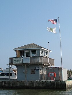
57:Davis Park Dockmaster Tower, Ferry Port and Marina
620:"THE OTHER FIRE ISLAND: A PLACE FROZEN IN TIME"
1402:
1016:
727:
8:
2546:Populated coastal places in New York (state)
2485:
1409:
1395:
1387:
1023:
1009:
1001:
912:Otis Pike Fire Island High Dune Wilderness
734:
720:
712:
647:"Fire Island Squatters. Fighting Eviction"
31:
307:The community extends along approximately
577:United States Department of the Interior
554:
473:
197:
164:
130:
95:
61:
49:
618:Weissmann, Richard (August 7, 1983).
221:
209:
181:
152:
140:
88:Location within the state of New York
7:
262:separated from the southern side of
2541:Hamlets in Suffolk County, New York
645:Kennedy, Shawn G. (July 13, 1978).
592:"Bayberry Dunes, 1963‐1976. R.I.P."
568:Geographic Names Information System
1417:Municipalities and communities of
590:Lipson, Eden (September 5, 1976).
408:In November 2009, the remnants of
254:, United States. It is located on
75:
25:
29:Hamlet in New York, United States
539:
530:
521:
512:
503:
494:
485:
476:
74:
67:
51:
573:United States Geological Survey
1:
867:Fire Island National Seashore
333:Island at Democrat Point (in
302:Fire Island National Seashore
280:Fire Island National Seashore
2536:Hamlets in New York (state)
1268:North Patchogue/Canaan Lake
976:Fire Island School District
2562:
699:Davis Park Ferry Co., Inc.
2504:
2496:
2488:
2461:
1511:
1431:
987:Bay Shore School District
984:
96:
62:
50:
41:
1420:Suffolk County, New York
626:. p. 1 Section 11LI
403:environmental monitoring
396:2009 Beach Renourishment
922:Smith Point County Park
877:Robert Moses State Park
795:Fire Island Summer Club
454:Robert Moses State Park
335:Robert Moses State Park
116:40.683806°N 73.005306°W
2267:Stony Brook University
2217:Shelter Island Heights
2157:Port Jefferson Station
1518:
1283:Port Jefferson Station
902:Talisman/Barrett Beach
882:Fire Island Lighthouse
846:Davis Park/Ocean Ridge
694:Davis Park Association
563:"Davis Park, New York"
300:after the creation of
2531:Fire Island, New York
1679:Village of the Branch
1517:
991:Islip School District
653:. p. 1 Section B
359:40.68444°N 73.00417°W
298:National Park Service
278:. It lies within the
184: • Summer (
121:40.683806; -73.005306
2526:Brookhaven, New York
2492:High Dune Wilderness
2474:United States portal
364:40.68444; -73.00417
355: /
112: /
1972:Huntington Station
1832:East Hampton North
1792:Cold Spring Harbor
1689:West Hampton Dunes
1579:Head of the Harbor
1519:
1032:Town of Brookhaven
651:The New York Times
624:The New York Times
596:The New York Times
244:Town of Brookhaven
2514:
2513:
2505:Succeeded by
2483:
2482:
2380:Fire Island Pines
2167:Remsenburg-Speonk
2102:North Lindenhurst
2097:North Great River
1684:Westhampton Beach
1384:
1383:
1198:Fire Island Pines
998:
997:
872:Fire Island Inlet
836:Fire Island Pines
800:Corneille Estates
233:
232:
176:Eastern Time Zone
16:(Redirected from
2553:
2489:Preceded by
2486:
2475:
2468:
2327:Wheatley Heights
2242:South Huntington
2222:Shinnecock Hills
2127:Northwest Harbor
2077:North Amityville
1827:East Farmingdale
1516:
1443:
1436:
1426:
1421:
1411:
1404:
1397:
1388:
1025:
1018:
1011:
1002:
907:Blue Point Beach
887:Lighthouse Beach
736:
729:
722:
713:
681:
680:
669:
663:
662:
660:
658:
642:
636:
635:
633:
631:
615:
609:
608:
606:
604:
587:
581:
580:
559:
543:
534:
525:
516:
507:
498:
489:
480:
370:
369:
367:
366:
365:
360:
356:
353:
352:
351:
348:
331:
330:
326:
316:
315:
311:
189:
127:
126:
124:
123:
122:
117:
113:
110:
109:
108:
105:
78:
77:
71:
55:
32:
21:
2561:
2560:
2556:
2555:
2554:
2552:
2551:
2550:
2516:
2515:
2510:
2494:
2484:
2479:
2473:
2467:New York portal
2466:
2457:
2434:
2410:South Jamesport
2341:
2107:North Patchogue
2087:North Bay Shore
1997:Lake Ronkonkoma
1772:Center Moriches
1693:
1520:
1514:
1509:
1446:
1441:
1434:
1427:
1424:
1419:
1415:
1385:
1380:
1362:
1223:Lake Ronkonkoma
1138:Center Moriches
1109:
1056:
1038:
1029:
999:
994:
980:
964:
936:
862:Great South Bay
850:
745:
740:
709:
690:
685:
684:
671:
670:
666:
656:
654:
644:
643:
639:
629:
627:
617:
616:
612:
602:
600:
589:
588:
584:
561:
560:
556:
551:
544:
535:
526:
517:
508:
499:
490:
481:
472:
445:
418:
398:
389:
363:
361:
357:
354:
349:
346:
344:
342:
341:
328:
324:
323:
313:
309:
308:
268:Great South Bay
206:
183:
120:
118:
114:
111:
106:
103:
101:
99:
98:
92:
91:
90:
89:
86:
85:
84:
83:
79:
58:
46:
37:
30:
23:
22:
15:
12:
11:
5:
2559:
2557:
2549:
2548:
2543:
2538:
2533:
2528:
2518:
2517:
2512:
2511:
2506:
2503:
2495:
2490:
2481:
2480:
2478:
2477:
2470:
2462:
2459:
2458:
2456:
2455:
2450:
2444:
2442:
2436:
2435:
2433:
2432:
2427:
2422:
2417:
2412:
2407:
2402:
2397:
2395:Point O' Woods
2392:
2390:Ocean Bay Park
2387:
2382:
2377:
2372:
2370:Cupsogue Beach
2367:
2362:
2357:
2351:
2349:
2343:
2342:
2340:
2339:
2334:
2329:
2324:
2319:
2314:
2309:
2304:
2302:West Bay Shore
2299:
2294:
2289:
2284:
2279:
2274:
2269:
2264:
2259:
2254:
2249:
2244:
2239:
2234:
2229:
2224:
2219:
2214:
2212:Shelter Island
2209:
2204:
2199:
2194:
2189:
2184:
2179:
2174:
2169:
2164:
2159:
2154:
2149:
2144:
2139:
2134:
2129:
2124:
2119:
2114:
2109:
2104:
2099:
2094:
2092:North Bellport
2089:
2084:
2079:
2074:
2069:
2064:
2059:
2054:
2049:
2044:
2039:
2034:
2029:
2024:
2019:
2014:
2009:
2004:
1999:
1994:
1989:
1984:
1979:
1974:
1969:
1964:
1959:
1954:
1949:
1944:
1939:
1937:Greenport West
1934:
1929:
1924:
1922:Gordon Heights
1919:
1914:
1909:
1904:
1902:Fishers Island
1899:
1894:
1889:
1884:
1879:
1874:
1869:
1864:
1859:
1857:East Patchogue
1854:
1852:East Northport
1849:
1844:
1839:
1834:
1829:
1824:
1819:
1814:
1809:
1804:
1799:
1794:
1789:
1784:
1779:
1774:
1769:
1764:
1759:
1754:
1749:
1744:
1739:
1734:
1729:
1724:
1719:
1717:Baiting Hollow
1714:
1709:
1703:
1701:
1695:
1694:
1692:
1691:
1686:
1681:
1676:
1671:
1666:
1661:
1656:
1651:
1646:
1644:Port Jefferson
1641:
1636:
1631:
1626:
1621:
1616:
1611:
1606:
1601:
1596:
1591:
1586:
1584:Huntington Bay
1581:
1576:
1571:
1566:
1561:
1556:
1551:
1546:
1541:
1536:
1530:
1528:
1522:
1521:
1512:
1510:
1508:
1507:
1502:
1497:
1492:
1490:Shelter Island
1487:
1482:
1477:
1472:
1467:
1462:
1456:
1454:
1448:
1447:
1432:
1429:
1428:
1416:
1414:
1413:
1406:
1399:
1391:
1382:
1381:
1379:
1378:
1372:
1370:
1364:
1363:
1361:
1360:
1355:
1350:
1345:
1340:
1335:
1330:
1325:
1320:
1315:
1310:
1305:
1300:
1295:
1290:
1285:
1280:
1278:Point O' Woods
1275:
1273:Ocean Bay Park
1270:
1265:
1263:North Bellport
1260:
1255:
1250:
1245:
1240:
1235:
1230:
1225:
1220:
1215:
1210:
1205:
1203:Gordon Heights
1200:
1195:
1190:
1185:
1180:
1175:
1173:East Patchogue
1170:
1165:
1160:
1158:Cupsogue Beach
1155:
1150:
1145:
1140:
1135:
1130:
1125:
1119:
1117:
1111:
1110:
1108:
1107:
1102:
1100:Port Jefferson
1097:
1092:
1087:
1082:
1077:
1072:
1066:
1064:
1058:
1057:
1055:
1054:
1048:
1046:
1040:
1039:
1030:
1028:
1027:
1020:
1013:
1005:
996:
995:
985:
982:
981:
979:
978:
972:
970:
966:
965:
963:
962:
957:
952:
946:
944:
938:
937:
935:
934:
929:
927:Moriches Inlet
924:
919:
917:Bellport Beach
914:
909:
904:
899:
894:
889:
884:
879:
874:
869:
864:
858:
856:
852:
851:
849:
848:
843:
838:
833:
828:
823:
818:
816:Ocean Bay Park
813:
808:
802:
797:
792:
787:
782:
777:
772:
767:
761:
755:
753:
747:
746:
741:
739:
738:
731:
724:
716:
707:
706:
701:
696:
689:
688:External links
686:
683:
682:
664:
637:
610:
582:
553:
552:
550:
547:
546:
545:
538:
536:
529:
527:
520:
518:
511:
509:
502:
500:
493:
491:
484:
482:
475:
471:
468:
467:
466:
461:
456:
451:
444:
441:
440:
439:
436:
433:
430:
429:entertainment.
426:
423:
417:
414:
397:
394:
388:
385:
260:barrier island
248:Suffolk County
231:
230:
227:
220:
219:
214:
208:
207:
204:
202:
196:
195:
190:
180:
179:
169:
163:
162:
157:
151:
150:
145:
139:
138:
135:
129:
128:
94:
93:
87:
81:
80:
73:
72:
66:
65:
64:
63:
60:
59:
56:
48:
47:
42:
39:
38:
35:
28:
24:
14:
13:
10:
9:
6:
4:
3:
2:
2558:
2547:
2544:
2542:
2539:
2537:
2534:
2532:
2529:
2527:
2524:
2523:
2521:
2509:
2502:
2501:
2493:
2487:
2476:
2471:
2469:
2464:
2463:
2460:
2454:
2451:
2449:
2446:
2445:
2443:
2441:
2437:
2431:
2428:
2426:
2423:
2421:
2418:
2416:
2413:
2411:
2408:
2406:
2403:
2401:
2398:
2396:
2393:
2391:
2388:
2386:
2383:
2381:
2378:
2376:
2373:
2371:
2368:
2366:
2365:Crystal Brook
2363:
2361:
2358:
2356:
2353:
2352:
2350:
2348:
2344:
2338:
2335:
2333:
2330:
2328:
2325:
2323:
2320:
2318:
2317:West Sayville
2315:
2313:
2310:
2308:
2305:
2303:
2300:
2298:
2295:
2293:
2290:
2288:
2285:
2283:
2280:
2278:
2275:
2273:
2270:
2268:
2265:
2263:
2260:
2258:
2255:
2253:
2250:
2248:
2245:
2243:
2240:
2238:
2235:
2233:
2230:
2228:
2225:
2223:
2220:
2218:
2215:
2213:
2210:
2208:
2205:
2203:
2200:
2198:
2195:
2193:
2190:
2188:
2185:
2183:
2180:
2178:
2175:
2173:
2170:
2168:
2165:
2163:
2160:
2158:
2155:
2153:
2150:
2148:
2145:
2143:
2140:
2138:
2135:
2133:
2130:
2128:
2125:
2123:
2120:
2118:
2115:
2113:
2110:
2108:
2105:
2103:
2100:
2098:
2095:
2093:
2090:
2088:
2085:
2083:
2082:North Babylon
2080:
2078:
2075:
2073:
2070:
2068:
2065:
2063:
2060:
2058:
2055:
2053:
2050:
2048:
2045:
2043:
2040:
2038:
2037:Middle Island
2035:
2033:
2030:
2028:
2025:
2023:
2020:
2018:
2015:
2013:
2010:
2008:
2005:
2003:
2000:
1998:
1995:
1993:
1990:
1988:
1985:
1983:
1982:Islip Terrace
1980:
1978:
1975:
1973:
1970:
1968:
1965:
1963:
1960:
1958:
1955:
1953:
1950:
1948:
1945:
1943:
1940:
1938:
1935:
1933:
1930:
1928:
1925:
1923:
1920:
1918:
1915:
1913:
1910:
1908:
1905:
1903:
1900:
1898:
1895:
1893:
1890:
1888:
1885:
1883:
1880:
1878:
1875:
1873:
1872:East Shoreham
1870:
1868:
1867:East Setauket
1865:
1863:
1860:
1858:
1855:
1853:
1850:
1848:
1847:East Moriches
1845:
1843:
1840:
1838:
1835:
1833:
1830:
1828:
1825:
1823:
1820:
1818:
1815:
1813:
1810:
1808:
1805:
1803:
1800:
1798:
1795:
1793:
1790:
1788:
1787:Central Islip
1785:
1783:
1780:
1778:
1775:
1773:
1770:
1768:
1765:
1763:
1760:
1758:
1755:
1753:
1752:Bridgehampton
1750:
1748:
1745:
1743:
1740:
1738:
1735:
1733:
1730:
1728:
1725:
1723:
1720:
1718:
1715:
1713:
1710:
1708:
1705:
1704:
1702:
1700:
1696:
1690:
1687:
1685:
1682:
1680:
1677:
1675:
1672:
1670:
1667:
1665:
1662:
1660:
1657:
1655:
1652:
1650:
1647:
1645:
1642:
1640:
1637:
1635:
1632:
1630:
1627:
1625:
1622:
1620:
1617:
1615:
1612:
1610:
1607:
1605:
1602:
1600:
1597:
1595:
1592:
1590:
1587:
1585:
1582:
1580:
1577:
1575:
1572:
1570:
1567:
1565:
1564:Dering Harbor
1562:
1560:
1557:
1555:
1552:
1550:
1547:
1545:
1542:
1540:
1537:
1535:
1532:
1531:
1529:
1527:
1523:
1506:
1503:
1501:
1498:
1496:
1493:
1491:
1488:
1486:
1483:
1481:
1478:
1476:
1473:
1471:
1468:
1466:
1463:
1461:
1458:
1457:
1455:
1453:
1449:
1445:
1444:
1437:
1430:
1425:United States
1422:
1412:
1407:
1405:
1400:
1398:
1393:
1392:
1389:
1377:
1374:
1373:
1371:
1369:
1365:
1359:
1356:
1354:
1351:
1349:
1346:
1344:
1341:
1339:
1336:
1334:
1331:
1329:
1326:
1324:
1321:
1319:
1316:
1314:
1311:
1309:
1306:
1304:
1301:
1299:
1296:
1294:
1291:
1289:
1286:
1284:
1281:
1279:
1276:
1274:
1271:
1269:
1266:
1264:
1261:
1259:
1256:
1254:
1251:
1249:
1246:
1244:
1243:Middle Island
1241:
1239:
1236:
1234:
1231:
1229:
1226:
1224:
1221:
1219:
1216:
1214:
1211:
1209:
1206:
1204:
1201:
1199:
1196:
1194:
1191:
1189:
1186:
1184:
1183:East Shoreham
1181:
1179:
1178:East Setauket
1176:
1174:
1171:
1169:
1168:East Moriches
1166:
1164:
1161:
1159:
1156:
1154:
1151:
1149:
1146:
1144:
1141:
1139:
1136:
1134:
1131:
1129:
1126:
1124:
1121:
1120:
1118:
1116:
1112:
1106:
1103:
1101:
1098:
1096:
1093:
1091:
1088:
1086:
1083:
1081:
1078:
1076:
1073:
1071:
1068:
1067:
1065:
1063:
1059:
1053:
1050:
1049:
1047:
1045:
1041:
1037:
1033:
1026:
1021:
1019:
1014:
1012:
1007:
1006:
1003:
992:
988:
983:
977:
974:
973:
971:
967:
961:
958:
956:
953:
951:
948:
947:
945:
943:
939:
933:
930:
928:
925:
923:
920:
918:
915:
913:
910:
908:
905:
903:
900:
898:
897:Sunken Forest
895:
893:
890:
888:
885:
883:
880:
878:
875:
873:
870:
868:
865:
863:
860:
859:
857:
853:
847:
844:
842:
839:
837:
834:
832:
829:
827:
824:
822:
821:Point O'Woods
819:
817:
814:
812:
809:
806:
803:
801:
798:
796:
793:
791:
788:
786:
783:
781:
778:
776:
773:
771:
768:
765:
762:
760:
757:
756:
754:
752:
748:
744:
737:
732:
730:
725:
723:
718:
717:
714:
710:
705:
702:
700:
697:
695:
692:
691:
687:
678:
677:www.asbpa.org
674:
668:
665:
652:
648:
641:
638:
625:
621:
614:
611:
599:. p. 239
598:
597:
593:
586:
583:
578:
574:
570:
569:
564:
558:
555:
548:
542:
537:
533:
528:
524:
519:
515:
510:
506:
501:
497:
492:
488:
483:
479:
474:
470:Photo gallery
469:
465:
464:Patchogue Bay
462:
460:
457:
455:
452:
450:
449:Outer Barrier
447:
446:
442:
437:
434:
431:
427:
424:
420:
419:
415:
413:
411:
410:Hurricane Ida
406:
404:
395:
393:
386:
384:
380:
376:
372:
368:
338:
336:
321:
305:
303:
299:
294:
290:
286:
283:
281:
277:
273:
269:
265:
261:
257:
253:
249:
245:
241:
237:
228:
225:
218:
215:
213:
203:
201:
194:
191:
187:
177:
173:
170:
168:
161:
158:
156:
149:
146:
144:
137:United States
136:
134:
125:
97:Coordinates:
70:
54:
45:
40:
33:
27:
19:
2508:Water Island
2497:
2440:Reservations
2430:Water Island
2420:Strongs Neck
2374:
2360:Cherry Grove
2297:West Babylon
2282:Wading River
2042:Miller Place
2017:Mastic Beach
1947:Hampton Bays
1912:Fort Salonga
1892:Farmingville
1604:Lloyd Harbor
1569:East Hampton
1559:Brightwaters
1470:East Hampton
1439:
1353:Water Island
1348:Wading River
1333:Strongs Neck
1248:Miller Place
1233:Mastic Beach
1193:Farmingville
1162:
1148:Cherry Grove
892:Seabay Beach
855:Destinations
845:
841:Water Island
831:Cherry Grove
790:Robbins Rest
708:
676:
667:
655:. Retrieved
650:
640:
628:. Retrieved
623:
613:
601:. Retrieved
594:
585:
566:
557:
407:
399:
390:
381:
377:
373:
339:
306:
295:
291:
287:
284:
235:
234:
212:Area code(s)
26:
2500:Fire Island
2498:Beaches of
2405:South Haven
2355:Canaan Lake
2322:Westhampton
2262:Stony Brook
2237:Sound Beach
2187:Rocky Point
2117:Northampton
2072:New Suffolk
2057:Mount Sinai
1927:Great River
1897:Fire Island
1882:Eatons Neck
1862:East Quogue
1842:East Marion
1674:Southampton
1624:Ocean Beach
1614:North Haven
1609:Nissequogue
1599:Lindenhurst
1549:Belle Terre
1500:Southampton
1435:County seat
1368:Reservation
1328:Stony Brook
1323:South Haven
1318:Sound Beach
1293:Rocky Point
1258:Mount Sinai
1070:Belle Terre
826:Oakleyville
805:Ocean Beach
780:Lonelyville
770:Fair Harbor
751:Communities
743:Fire Island
362: /
274:village of
272:South Shore
264:Long Island
256:Fire Island
119: /
107:73°0′19.1″W
104:40°41′1.7″N
2520:Categories
2453:Shinnecock
2448:Poospatuck
2400:Remsenburg
2375:Davis Park
2312:West Islip
2307:West Hills
2292:Water Mill
2272:Terryville
2192:Ronkonkoma
2122:Northville
2007:Manorville
1992:Kings Park
1967:Huntington
1962:Holtsville
1837:East Islip
1782:Centerport
1777:Centereach
1757:Brookhaven
1737:Blue Point
1707:Amagansett
1659:Sagaponack
1654:Sag Harbor
1594:Lake Grove
1534:Amityville
1475:Huntington
1465:Brookhaven
1376:Poospatuck
1338:Terryville
1298:Ronkonkoma
1218:Holtsville
1163:Davis Park
1143:Centereach
1128:Brookhaven
1123:Blue Point
1080:Lake Grove
960:Brookhaven
932:Watch Hill
785:Atlantique
657:August 25,
630:August 25,
603:August 25,
549:References
459:Watch Hill
350:73°00′15″W
347:40°41′04″N
320:Watch Hill
236:Davis Park
226:feature ID
82:Davis Park
36:Davis Park
18:Davis Park
2332:Wyandanch
2287:Wainscott
2257:St. James
2232:Smithtown
2182:Riverside
2177:Riverhead
2137:Oak Beach
2112:North Sea
2067:Nesconset
2022:Mattituck
1987:Jamesport
1952:Hauppauge
1932:Greenlawn
1822:Dix Hills
1817:Deer Park
1812:Cutchogue
1762:Calverton
1747:Brentwood
1722:Bay Shore
1712:Aquebogue
1634:Patchogue
1629:Old Field
1619:Northport
1574:Greenport
1539:Asharoken
1495:Smithtown
1485:Riverhead
1442:Riverhead
1133:Calverton
1090:Patchogue
1085:Old Field
969:Education
807:(village)
766:(village)
276:Patchogue
193:UTC−04:00
172:UTC−05:00
167:Time zone
2385:Hagerman
2277:Tuckahoe
2247:Southold
2207:Setauket
2197:Sayville
2062:Napeague
2052:Moriches
2032:Melville
1957:Holbrook
1942:Halesite
1907:Flanders
1877:Eastport
1802:Copiague
1669:Shoreham
1664:Saltaire
1589:Islandia
1554:Bellport
1526:Villages
1505:Southold
1308:Setauket
1253:Moriches
1213:Holbrook
1208:Hagerman
1188:Eastport
1105:Shoreham
1075:Bellport
1062:Villages
1036:New York
775:Dunewood
764:Saltaire
443:See also
270:off the
252:New York
217:631, 934
200:ZIP Code
148:New York
2347:Hamlets
2337:Yaphank
2252:Springs
2227:Shirley
2162:Quiogue
2152:Peconic
2142:Oakdale
2047:Montauk
2027:Medford
1797:Commack
1767:Captree
1742:Bohemia
1732:Baywood
1727:Bayport
1639:Poquott
1544:Babylon
1460:Babylon
1358:Yaphank
1313:Shirley
1238:Medford
1115:Hamlets
1095:Poquott
1052:Suffolk
950:Babylon
811:Seaview
673:"ASBPA"
416:Tourism
387:History
327:⁄
312:⁄
266:by the
242:in the
160:Suffolk
133:Country
2415:Speonk
2202:Selden
2147:Orient
2132:Noyack
2012:Mastic
2002:Laurel
1887:Elwood
1649:Quogue
1303:Selden
1228:Mastic
1044:County
759:Kismet
240:hamlet
229:948069
155:County
44:Hamlet
2425:Upton
2172:Ridge
1977:Islip
1917:Gilgo
1807:Coram
1480:Islip
1452:Towns
1343:Upton
1288:Ridge
1153:Coram
955:Islip
942:Towns
422:cars.
238:is a
205:11772
143:State
1699:CDPs
989:and
659:2021
632:2021
605:2021
258:, a
224:GNIS
337:).
186:DST
2522::
1438::
1423:,
1034:,
675:.
649:.
622:.
575:,
571:.
565:.
371:.
282:.
250:,
246:,
1410:e
1403:t
1396:v
1024:e
1017:t
1010:v
735:e
728:t
721:v
679:.
661:.
634:.
607:.
579:.
329:2
325:1
314:4
310:3
188:)
178:)
174:(
20:)
Text is available under the Creative Commons Attribution-ShareAlike License. Additional terms may apply.