819:
173:
1906:. A narrow broken ridge 2 nautical miles (3.7 km; 2.3 mi) south of Williams Cliff on Ross Island. The feature rises to about 1,000 metres (3,300 ft) high and marks a declivity along the north flank of broad Turks Head Ridge, from which ice moves to Pukaru Icefalls. Named by US-ACAN (2000) after the New Mexico Institute of Mining and Technology, known as New Mexico Tech. From 1981, many Tech students under the direction of Philip R. Kyle, have undertaken graduate research projects (thesis and dissertation) on Mount Erebus.
166:
1486:. The feature is 1.2 nautical miles (2.2 km; 1.4 mi) west-northwest of Abbott Peak. At the suggestion of P.R. Kyle, named by Advisory Committee on Antarctic Names (US-ACAN) (2000) after Sarah Krall who worked over 10 years in providing support to science in Antarctica. She was cook and camp manager at the lower Erebus Hut during the 1992-93 NSF-NASA Dante robot experiment on Mount Erebus. She also managed the food room at McMurdo Station, was the hovercraft pilot, and has also been a helicopter technician.
1948:
2070:. A rock bluff rising to about 600 metres (2,000 ft) high in the south part of Turks Head Ridge. The bluff is 1.5 nautical miles (2.8 km; 1.7 mi) north-northeast of Turks Head. At the suggestion of P.R. Kyle, named by US-ACAN (2000) after Grazyna Zreda-Gostynska, who worked on Mount Erebus in 1989-90 as a member of the New Mexico Institute of Mining and Technology team. A Ph.D. student at NMIMT, she completed her doctoral dissertation on the gas emissions from Mount Erebus.
2032:. A rock bluff rising to about 600 metres (2,000 ft) high on the southeast margin of Turks Head Ridge. The bluff is 1.1 nautical miles (2.0 km; 1.3 mi) east-northeast of Grazyna Bluff. At the suggestion of P.R. Kyle, named by US-ACAN (2000) after Richard Esser, a member of New Mexico Tech field parties on Mount Erebus in the 1993-94 and 1994-95 seasons; later a technician in the New Mexico Geochronology Lab at NM Tech, where he has dated many rocks from Antarctica.
2129:
906:(more accurately, "flat-light") phenomenon. Further investigation of the crash showed a navigational error in flight documentation by Air New Zealand and a cover-up that resulted in about $ 100 million in lawsuits. Air New Zealand discontinued its flyovers of Antarctica. Its final flight was on February 17, 1980. During the Antarctic summer, snow melt on the flanks of Mount Erebus continually reveals debris from the crash that is visible from the air.
4856:
1124:
2271:
1169:. Prominent cliffs at about 3,525 metres (11,565 ft) high on the north rim of the summit caldera of Mount Erebus. The name derives from a nearby United States Coast Guard (USCG) HH-52A helicopter (CG 1404) which lost power and crashed while enroute from McMurdo Station to Cape Bird, Jan. 9, 1971. The four crew and passengers were not injured, but the helicopter was abandoned because of its location.
915:
2108:. A broad north–south ridge, 4.5 nautical miles (8.3 km; 5.2 mi) long and 0.8 nautical miles (1.5 km; 0.92 mi) wide, on the south slopes of Mount Erebus. Completely ice covered, the ridge descends from about 2,200 metres (7,200 ft) high to 600 metres (2,000 ft) high, terminating 2.1 nautical miles (3.9 km; 2.4 mi) northwest of
402:
717:
1681:. A peak rising to about 1,600 metres (5,200 ft) high on the northeast slope of Mount Erebus, 3.6 nautical miles (6.7 km; 4.1 mi) east of the summit of Fang Ridge. Named by the New Zealand Geographic Board (NZGB) (2000) after Father Coleman, a New Zealand chaplain, who traveled to Antarctica many times with the United States Antarctic Program.
902:
landmarks visible 13 miles (21 km) to the left and 10 miles (16 km) to the right of the aircraft. The mountain directly ahead was lit by sunlight shining from directly behind the aircraft through the cloud deck above, resulting in a lack of shadows that made Mount Erebus effectively invisible against the overcast sky beyond in a classic
546:– ice towers that form around gases that escape from vents in the surface. The ice caves associated with the fumaroles are dark, in polar alpine environments starved in organics and with oxygenated hydrothermal circulation in highly reducing host rock. The life is sparse, mainly bacteria and fungi. This makes it of special interest for studying
4086:
3564:
1868:. This rock cliff was mapped by the British Antarctic Expedition under Scott, 1910-13, and identified simply as "Bold Cliff on maps resulting from that expedition. It was named Williams Cliff by the US-ACAN in 1964 to commemorate Richard T. Williams, who losi: his life when his tractor broke through the ice at McMurdo Sound in January 1956.
53:
1283:. A concave slope, about 3,650 metres (11,980 ft) high, just south of Crystal Slope on the west side of the summit cone of Mount Erebus. The feature is the site of a slump which has occurred off the crater rim. It is also a former camp site used by summit parties. A small hut is located on the upper part of the slope.
1727:
on the lower northeast slope of Mount Erebus. On
November 28, 1979, a New Zealand DC10 aircraft on a scenic flight from Auckland crashed near this peak claiming the lives of 237 passengers from eight countries and a crew of 20. In 1987, a stainless steel memorial cross was erected west of the peak.
1397:
A prominent outcropping of jumbled rocks, 3,633 metres (11,919 ft) high, formed as a lava flow on the northwest upper slope of the active cone of Mount Erebus. The feature is near a camp site used mainly in the 1970s by teams working at the summit of the volcano. So named because many working
528:
around Mount Erebus to listen to waves of energy generated by small, controlled blasts from explosives they buried along its flanks and perimeter, and to record scattered seismic signals generated by lava lake eruptions and local ice quakes. By studying the refracted and scattered seismic waves, the
1778:
to the crater of Mount Erebus. The cone itself is about 100 metres (330 ft) high high and is surrounded by a deep moat or ditch, caused by the sweeping action of strong winds. It was named by F. Debenham on the second ascent of Mount Erebus for F.J. Hooper, a steward of the
British Antarctic
1524:
A nunatak rising to about 1,700 metres (5,600 ft) high on the northwest slope of Mount Erebus. The feature is 1.2 nautical miles (2.2 km; 1.4 mi) south-southwest of Abbott Peak. Named by New
Zealand Geographic Board (NZGB) (2000) after Sergeant L.W. (Wally) Tarr, Royal New Zealand
428:
from the lava lake or from one of several subsidiary vents, all within the volcano's inner crater. The volcano is scientifically remarkable in that its relatively low-level and unusually persistent eruptive activity enables long-term volcanological study of a
Strombolian eruptive system very close
1567:. A conspicuous ridge on the northeast slope of Mount Erebus. It is a much denuded portion of the original caldera rim left by a catastrophic eruption. So named, probably for its curved shape, by Frank Debenham of the British Antarctic Expedition, 1910-13, who made a plane table survey in 1912.
553:
The caves on Erebus are of special interest for astrobiology, as most surface caves are influenced by human activities, or by organics from the surface brought in by animals (e.g. bats and birds) or ground water. The caves at Erebus are at high altitude, yet accessible for study. Some of the caves
901:
aircraft and began in
February 1977. The flight crashed into Mount Erebus on November 28, 1979, killing all 257 people on board. Passenger photographs taken seconds before the collision ruled out the "flying in a cloud" theory, showing perfectly clear visibility well beneath the cloud base, with
520:
Microscopic gold particles have been found up to 1000 kilometers from Mount Erebus, ranging in size up to 60 micrometres. A 1991 paper shows that these particles condense from the volcano's emissions that include 80 grams of gold vapor daily. This amount of gold vapor is low compared to other
593:
S). Many of them are completely dark, so cannot support photosynthesis. Organics can only come from the atmosphere, or from ice algae that grow on the surface in summer, which may eventually find their way into the caves through burial and melting. As a result, most micro-organisms there are
554:
can reach temperatures of 25 degrees
Celsius (77 degrees Fahrenheit), and with light near the cave mouths, in some caves covered by thin overlying ice the light reach even deeper, is sufficient to sustain an ecosystem of flora and fauna consisting of moss, algae, arthropods and nematodes.
1605:. A distinctive toothlike peak, 3,159 metres (10,364 ft) high, which forms the highest point of Fang Ridge. Descriptively named by Frank Debenham of British Antarctic Expedition (British Antarctic Expedition), 1910-13, who made a plane table survey of the vicinity in 1912.
995:. The topographic feature that embraces the crater within the floor of Main Crater, at the summit of Mount Erebus. Inner Crater contains an active anorthoclase-phonolite lava lake. The name derives from the fact that the crater is within the Main Crater of Mount Erebus.
1774:. An independent cone at an elevation of 1,800 metres (5,900 ft) high on the west slopes of Mount Erebus. From McMurdo Sound it appears as a perfect pyramid of black rock, standing out as a splendid mark against the background of the ice and almost on a line from
1643:. A peak rising to about 1,800 metres (5,900 ft) high on the northeast slope of Mount Erebus, 4 nautical miles (7.4 km; 4.6 mi) east-northeast of the Erebus summit. So named by Advisory Committee on Antarctic Names (US-ACAN) in the millennium year 2000.
851:
had not yet reached the bottom of the crater, no data of volcanic significance was recorded. The expedition proved to be highly successful in terms of robotic and computer science, and was possibly the first expedition by a robotic platform to
Antarctica.
1817:
Two rock summits at about 1,500 metres (4,900 ft) high on the west slope of Mount Erebus. The feature is 0.6 nautical miles (1.1 km; 0.69 mi) southwest of
Hoopers Shoulder. At the suggestion of P.R. Kyle, named by United States
1321:. A gully at about 3,675 metres (12,057 ft) high on the northwest side of the summit crater of Mount Erebus. The feature was used as the access route from a NASA robot called Dante that was carried to the crater rim, Jan. 1, 1993.
1359:. A western slope, 3,700 metres (12,100 ft) high, between Camp Slope and Robot Gully, leading down from the summit crater rim of Mount Erebus. So named because the slope includes a talus of large anorthoclase feldspar crystals.
1444:. Pyramidal peak on the north side of Mount Erebus, between it and Mount Bird. Charted by the British Antarctic Expedition under Scott, 1910-13, and named for Petty Officer George P. Abbott, Royal Navy, a member of the expedition.
485:
lavas crop out on Fang Ridge – an eroded remnant of an early Erebus volcano – and at other isolated locations on the flanks of Erebus. Erebus is the world's only presently erupting phonolite volcano.
957:. The topographic feature that rises to about 3,750 metres (12,300 ft) high and forms the primary summit crater of Mount Erebus. Inner Crater, which lies within Main Crater, contains an anorthoclase-phonolite lava lake.
505:-6 eruption that occurred 18,000 ± 7,000 years ago. It is filled with small volume tephritic phonolite and phonolite lava flows. In the center of the summit caldera is a small, steep-sided cone composed primarily of decomposed
4090:
3568:
533:
rises to the lava lake. These results demonstrated a complex upper-volcano conduit system with appreciable upper-volcano magma storage to the northwest of the lava lake at depths hundreds of meters below the surface.
4241:
1033:
A nearly circular crater, about 3,700 metres (12,100 ft) high, situated at the summit of Mount Erebus on the southwest crater rim. Named for its location on the side of the main summit cone of Mount Erebus.
2596:
Although the flux of emitted Au is low compared to other volcanoes, crystalline particulate Au has been found in the plume near the crater, in ambient air up to 1000km from the volcano and in near surface
1245:. A ridge at about 3,540 metres (11,610 ft) high that descends the southwest slope of the summit crater of Mount Erebus. So named because the ridge is defined by a series of fumarolic ice towers.
1826:(USARP) team member on Mount Erebus in 1978-79 while a Fulbright scholar at Victoria University of Wellington; worked again on Mount Erebus, 1988-89; later Professor of Geology, University of Oregon.
1944:. Three aligned cones at an elevation of about 1,800 metres (5,900 ft) high on the southwest slopes of Mount Erebu. Named by members of the British Antarctic Expedition, 1910-13, under Scott.
2171:. A glacier on the west side of Fang Ridge, separating the old and new craters of Mount Erebus. Charted by Frank Debenham of the BrAE, 1910–13, and named by him in association with Fang Ridge.
113:
847:
successfully scaled a significant portion of the crater before technical difficulties emerged with the fibre-optic cable used for communications between the walker and base station. Since
4234:
2120:
operated as a US Navy ship. Along with other Navy icebreakers, Glacier was transferred to the US Coast Guard fleet, June 1966, from which she operated until decommissioned, June 1987.
2321:
where it forms a steep ice cliff. Discovered by the BrNAE, 1901–04, under Scott. Named by the
British Antarctic Expedition, 1907–09, under Shackleton after nearby Cape Barne.
5999:
4227:
2267:. The seaward extension of Erebus Glacier from Ross Island, projecting into Erebus Bay where part of it is floating. Charted and named by the BrNAE under Scott, 1901-04.
598:
i.e. microbes that get all of their energy from chemical reactions with the rocks, and that do not depend on any other lifeforms to survive. The organisms survive using CO
497:(about 30°) tephritic phonolite lava flows with large-scale flow levees. A conspicuous break in slope around 3,200 m ASL calls attention to a summit plateau representing a
1994:
for a few miles up the slopes of Mount Erebus. Mapped by the
British Antarctic Expedition, 1910-13, under Scott and so named because of its association with Turks Head.
839:
was designed to acquire gas samples from the magma lake inside the inner crater of Mount Erebus to understand the chemistry better through the use of the on-board gas
2116:, an icebreaker which for three decades, 1955-56 to 1986-87, supported scientific activity in Antarctica and Ross Sea on virtually an annual basis. From 1955-56,
803:
and Phillip Brocklehurst (who did not reach the summit), in 1908. Its first known solo ascent and the first winter ascent was accomplished by British mountaineer
753:
Lower “Camp E” site (HSM 90) consists of a slightly elevated area of gravel, as well as some aligned rocks, which may have been used to weight the tent valances.
818:
1207:
Steep bluff at about 3,470 metres (11,380 ft) high on the southwest rim of the summit caldera of Mount Erebus. So named after a seismic station nearby.
1864:. A prominent rock cliff that stands out from the ice-covered southwest slopes of Mount Erebus, situated 6 nautical miles (11 km; 6.9 mi) east of
165:
4643:
4250:
758:
4771:
807:
on 7 June 1985, a member of the "In the Footsteps of Scott" expedition. On 19–20 January 1991, Charles J. Blackmer, an iron-worker for many years at
4353:
4076:
4055:
4034:
4013:
3992:
3971:
3950:
3929:
3891:
3870:
3824:
3803:
3782:
3761:
3740:
3719:
3698:
3677:
3656:
3635:
3614:
3593:
1823:
861:
5979:
4307:
3572:
3551:
1526:
1131:
Mount Erebus has several named features on its slopes, including a number of rock formations. Features around the summit of the mountain include:
6019:
1072:
A small circular crater at 3,561 metres (11,683 ft) high on the western slope of the summit of Mount Erebus. So named for its location.
455:. The bottom half of the volcano is a shield and the top half is a stratocone. The composition of the current eruptive products of Erebus are
4886:
3117:
2978:
2220:
1819:
557:
They are dynamic systems that collapse and rebuild, but persist over decades. The air inside the caves has 80 to 100% humidity, and up to 3%
4194:
2722:
6009:
4801:
4067:
4046:
4025:
4004:
3983:
3962:
3941:
3920:
3882:
3861:
3815:
3794:
3773:
3752:
3731:
3710:
3689:
3668:
3647:
3626:
3605:
3584:
4062:
4041:
3999:
3957:
3936:
3915:
3877:
3856:
3789:
3768:
3747:
3726:
3705:
3684:
3663:
3642:
3600:
3579:
5303:
5207:
4597:
4020:
3978:
3810:
3621:
2653:"Internal structure of Erebus volcano, Antarctica imaged by high-resolution active-source seismic tomography and coda interferometry"
6014:
5984:
4121:
3044:
3015:
2438:
529:
scientists produced an image of the uppermost (top few km) of the volcano to understand the geometry of its "plumbing" and how the
2112:. In association with the names of expedition ships grouped on this island, named after United States Coast Guard Cutter (USCGC)
5974:
4751:
375:
4440:
4138:
4094:
4072:
4051:
4030:
4009:
3988:
3967:
3946:
3925:
3887:
3866:
3820:
3799:
3778:
3757:
3736:
3715:
3694:
3673:
3652:
3631:
3610:
3589:
2657:
2468:
2330:
746:, who also collected geological samples. Two of the camp sites they used have been recognised for their historic significance:
2504:
Burgisser, Alain; Oppenheimer, Clive; Alletti, Marina; Kyle, Philip R.; Scaillet, Bruno; Carroll, Michael R. (November 2012).
750:
Upper “Summit Camp” site (HSM 89) consists of part of a circle of rocks, which were probably used to weight the tent valances.
2313:. Steep glacier which descends from the west slopes of Mount Erebus and terminates on the west side of Ross Island between
843:, as well as measuring the temperature inside the volcano and the radioactivity of the materials present in such volcanoes.
4668:
2806:
Tebo, Bradley M.; Davis, Richard E.; Anitori, Roberto P.; Connell, Laurie B.; Schiffman, Peter; Staudigel, Hubert (2015).
2748:
2385:
669:
5572:
5253:
4761:
2578:
2080:
2042:
1878:
1789:
1691:
1653:
1615:
1577:
1496:
1454:
1369:
1255:
1217:
1179:
1141:
1044:
929:
344:
106:
2705:
2004:
1331:
1293:
1005:
967:
5479:
265:
86:
2763:
5989:
5494:
4733:
4463:
4317:
4113:
2866:
2610:
502:
449:
390:
5969:
5227:
4879:
644:
524:
Researchers spent more than three months during the 2007–08 field season installing an atypically dense array of
363:
2285:
2239:
2187:
2143:
1962:
1916:
1836:
1746:
1539:
1416:
5994:
5557:
5542:
5334:
5268:
4966:
4781:
4756:
3836:
701:
619:
3060:
Wettergreen, David; Thorpe, Chuck; Whittaker, Red (December 1993). "Exploring Mount Erebus by Walking Robot".
1728:
Te Puna Roimata Peak (meaning spring of tears) was named by the New Zealand Geographic Board (NZGB) in 2000.
1719:. A peak about 890 metres (2,920 ft) high, located 1.5 nautical miles (2.8 km; 1.7 mi) west of
1085:
429:(hundreds of metres) to the active vents, a characteristic shared with only a few volcanoes on Earth, such as
470:, which are the bulk of exposed lava flow on the volcano. The oldest eruptive products consist of relatively
5552:
4381:
3841:
898:
762:
471:
2884:
Harris, Rosie (2019). "Micro-organisms in the volcanic vents of Erebus - a key to life on other planets?".
2788:
2554:
5537:
5389:
4743:
4678:
3069:
1947:
258:
240:
78:
5721:
5504:
2505:
2232:
874:
869:
740:
725:
615:
595:
99:
35:
635:
Mount Erebus was discovered on 27 January 1841 (and observed to be in eruption), by polar explorer Sir
602:
fixation and some may use CO oxidization for the metabolism. The main types of microbe found there are
389:
in its inner summit crater that has been present since at least the early 1970s. On 28 November, 1979,
5106:
4872:
4816:
4617:
4529:
4458:
2666:
2520:
2476:
890:
677:
425:
6004:
5846:
5790:
5770:
5116:
4936:
4572:
4562:
4363:
4335:
4134:
3074:
2808:"Microbial communities in dark oligotrophic volcanic ice cave ecosystems of Mt. Erebus, Antarctica"
1112:
815:, accomplished a solo ascent in about 17 hours completely unsupported, by snow mobile and on foot.
736:
463:
230:
5101:
2914:
A Voyage of Discovery and Research in the Southern and Antarctic Regions, During the Years 1839-43
2637:
2576:(August 1991). "Emission of elemental gold particles from Mount Erebus, Ross Island, Antarctica".
2219:
where it forms the floating Erebus Glacier Tongue. Named in association with Mount Erebus by the
412:
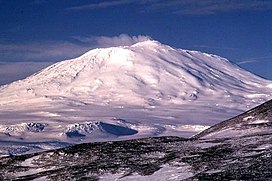
Mount Erebus is the world's southernmost active volcano. It is the current eruptive centre of the
5711:
4534:
4524:
4173:
4157:
3087:
2684:
2536:
1720:
1107:
903:
94:
5364:
4214:
4199:
4137:; Phillips, Erin H.; Wallace, Paul J.; Mattioli, Glen S.; Rasmussen, Dan; Boyd, Eric S. (2021).
804:
2215:. A glacier draining the lower south slopes of Mount Erebus, Ross Island, and flowing west to
1482:. Two rock summits rising to over 1,400 metres (4,600 ft) high on the northwest slope of
5934:
5691:
5339:
4834:
4723:
4683:
4312:
4165:
4117:
3123:
3113:
3040:
3011:
2984:
2974:
2912:
2893:
2847:
2829:
2742:
2444:
2434:
780:
774:
721:
705:
655:
648:
382:
4219:
4215:
List of published research about Mount Erebus, maintained by Mount Erebus Volcano Observatory
2931:
1102:
521:
volcanoes, but the condensation from vapor into gold particles is the first ever documented.
5653:
5603:
5489:
5374:
5308:
5222:
5182:
5177:
5096:
4916:
4718:
4417:
4302:
4284:
4149:
3079:
2837:
2819:
2674:
2587:
2528:
2484:
2335:
878:
860:
636:
586:
371:
301:
4859:
2944:
2128:
1123:
362:). It is the highest point on Ross Island, which is also home to three inactive volcanoes:
5944:
5901:
5836:
5716:
5706:
5701:
5618:
5613:
5418:
5359:
5273:
5217:
5081:
5051:
4941:
4921:
4766:
4728:
4708:
4688:
4653:
4582:
4409:
4399:
4294:
2709:
894:
808:
792:
784:
697:
640:
607:
566:
434:
356:
336:
286:
215:
207:
4855:
2670:
2638:"Plumbing Erebus: Scientists use seismic technique to map interior of Antarctic volcano"
2524:
2480:
5929:
5924:
5841:
5795:
5785:
5780:
5696:
5499:
5463:
5438:
5379:
5349:
5283:
5036:
4931:
4806:
4713:
4658:
4625:
4607:
4450:
4394:
2842:
2807:
2180:
788:
685:
558:
514:
494:
481:
lavas that form the low broad platform shield of Erebus. Slightly younger basanite and
413:
328:
2270:
761:
following a proposal by the United Kingdom, New Zealand, and the United States to the
493:
erupted after the basanite. The upper slopes of Mount Erebus are dominated by steeply
5963:
5939:
5906:
5891:
5876:
5866:
5731:
5686:
5648:
5628:
5608:
5516:
5484:
5428:
5384:
5313:
5212:
5152:
5091:
5076:
5006:
4986:
4911:
4786:
4693:
4673:
4567:
4514:
4496:
4478:
4422:
4389:
4186:
4177:
3083:
3033:
2688:
2615:
2411:
840:
800:
796:
681:
662:
611:
603:
482:
452:
253:
245:
2540:
5881:
5821:
5760:
5658:
5643:
5623:
5582:
5511:
5453:
5448:
5354:
5344:
5232:
5187:
5167:
5046:
5041:
5031:
5011:
5001:
4776:
4703:
4698:
4552:
4509:
4486:
4327:
3542:
3091:
3004:
2573:
510:
456:
405:
401:
359:
348:
280:
31:
433:
in Italy. Scientific study of the volcano is also facilitated by its proximity to
2651:
Zandomeneghi, D.; Aster, R.; Kyle, P.; Barclay, A.; Chaput, J.; Knox, H. (2013).
385:. The volcano has been active for around 1.3 million years and has a long-lived
5886:
5861:
5856:
5726:
5676:
5633:
5443:
5433:
5423:
5369:
5329:
5237:
5202:
5172:
5157:
5121:
5086:
5066:
5016:
4976:
4971:
4895:
4796:
4648:
4635:
4587:
4519:
4468:
4432:
882:
525:
460:
442:
332:
198:
3831:
2389:
5896:
5871:
5851:
5831:
5826:
5811:
5765:
5681:
5638:
5598:
5547:
5532:
5458:
5258:
5197:
5147:
5142:
5056:
5026:
4991:
4981:
4926:
4824:
4791:
4602:
4557:
4504:
4371:
4276:
4266:
4258:
4209:
2448:
2318:
2314:
2216:
2109:
1991:
1865:
1775:
914:
897:
flyover service, for the purposes of Antarctic sightseeing, was operated with
886:
812:
547:
438:
367:
340:
202:
4204:
4169:
4161:
3127:
2897:
2833:
2824:
2300:
2287:
2254:
2241:
2202:
2189:
2158:
2145:
2095:
2082:
2057:
2044:
2019:
2006:
1977:
1964:
1931:
1918:
1893:
1880:
1851:
1838:
1804:
1791:
1761:
1748:
1706:
1693:
1668:
1655:
1630:
1617:
1592:
1579:
1554:
1541:
1511:
1498:
1469:
1456:
1431:
1418:
1384:
1371:
1346:
1333:
1308:
1295:
1270:
1257:
1232:
1219:
1194:
1181:
1156:
1143:
1059:
1046:
1020:
1007:
982:
969:
944:
931:
129:
115:
5816:
5775:
5577:
5567:
5562:
5298:
5293:
5288:
5278:
5263:
5192:
5126:
5111:
5071:
5061:
4996:
4842:
4577:
4345:
2988:
2702:
2462:
Aster, R.; Mah, S.; Kyle, P.; McIntosh, W.; Dunbar, N.; Johnson, J. (2003).
1779:
Expedition, 1910-13. Hooper was one of the party making the second ascent.
1724:
1097:
918:
Satellite picture of Mount Erebus showing glow from its persistent lava lake
543:
506:
475:
467:
430:
421:
417:
386:
17:
2851:
517:. The active lava lake in this summit cone undergoes continuous degassing.
1398:
at the camp suffered from nausea due to high elevation mountain sickness.
716:
5021:
4663:
4544:
2532:
2489:
2463:
570:
490:
478:
381:
The mountain was named by Captain James Clark Ross in 1841 for his ship,
3898:
2971:
A Walk to the Pole: To the Heart of Antarctica in the Footsteps of Scott
2433:. Antarctic Research Series. Washington DC: American Geophysical Union.
4153:
2679:
2652:
578:
498:
352:
2591:
343:. With a summit elevation of 3,792 metres (12,441 ft), it is the
52:
779:
Mount Erebus' summit crater rim was first achieved by members of Sir
689:
666:
68:
2431:
Volcanological and Environmental Studies of Mount Erebus, Antarctica
1525:
Air Force, aircraft mechanic with the New Zealand contingent of the
4195:
A picture from space of the lava lake at the summit of Mount Erebus
2506:"Backward Tracking of Gas Chemistry Measurements at Erebus Volcano"
735:
The mountain was surveyed in December 1912 by a science party from
2945:"List of Historic Sites and Monuments approved by the ATCM (2013)"
2269:
2127:
1946:
1122:
859:
817:
715:
693:
530:
400:
4868:
4223:
4864:
550:– organisms that can survive on minimal amounts of resources.
307:
2729:. 17 February 2017. Archived from the original on 6 May 2021
316:
4133:
Sims, Kenneth W. W.; Aster, Richard C.; Gaetani, Glenn \;
2353:
2351:
622:
to study the micro-organisms in the geothermal fumaroles.
393:
crashed on Mount Erebus, killing all 257 people on board.
3508:
3506:
3337:
3335:
1736:
Features of the southern slopes of the mountain include:
1723:
and 2 nautical miles (3.7 km; 2.3 mi) south of
310:
2867:"Antarctic Cave Microbes Shed Light on Life's Diversity"
2368:
2366:
2464:"Very long period oscillations of Mount Erebus volcano"
424:
on Earth. Characteristic eruptive activity consists of
3389:
2572:
Meeker, Kimberly A.; Chuan, Ray L.; Kyle, Philip R.;
319:
4110:
Volcanoes of the Antarctic Plate and Southern Oceans
2969:
Mear, Roger; Swan, Robert; Fulcher, Lindsay (1987).
313:
5915:
5804:
5753:
5744:
5667:
5591:
5525:
5472:
5411:
5402:
5322:
5246:
5135:
4959:
4950:
4902:
4833:
4815:
4742:
4634:
4616:
4543:
4495:
4477:
4449:
4431:
4408:
4380:
4362:
4344:
4326:
4293:
4275:
4257:
2789:"Secret Life May Thrive Under Warm Antarctic Caves"
831:In 1992, the inside of the volcano was explored by
304:
279:
274:
264:
252:
239:
229:
224:
214:
194:
153:
105:
93:
77:
67:
62:
45:
3032:
3003:
501:. The summit caldera was created by an explosive
4205:A panoramic view from the summit of Mount Erebus
4108:LeMasurier, W. E.; Thomson, J. W., eds. (1990).
3365:
3194:
2388:. Australian Antarctic Division. Archived from
3497:
3485:
3413:
3278:
3230:
416:. The summit contains a persistent convecting
4880:
4235:
3377:
3326:
3170:
1990:. A mostly ice-covered ridge extending from
1822:(US-ACAN) (2000) after Katherine V. Cashman,
835:, an eight legged tethered robotic explorer.
542:Mount Erebus is notable for its numerous ice
489:Lava flows of more viscous phonotephrite and
8:
3473:
3314:
3290:
3266:
3242:
3218:
3206:
3182:
3158:
2917:. Vol. 1. John Murray. p. 216-218.
2357:
893:to refuel before returning to Auckland. The
345:second most prominent mountain in Antarctica
3437:
3254:
6000:Historic Sites and Monuments of Antarctica
5750:
5408:
4956:
4887:
4873:
4865:
4251:Historic Sites and Monuments in Antarctica
4242:
4228:
4220:
42:
3353:
3103:
3101:
3073:
2841:
2823:
2678:
2488:
1406:Features on the northern slopes include:
877:was a scheduled sightseeing service from
4354:Pole of Inaccessibility research station
4077:United States Department of the Interior
4056:United States Department of the Interior
4035:United States Department of the Interior
4014:United States Department of the Interior
3993:United States Department of the Interior
3972:United States Department of the Interior
3951:United States Department of the Interior
3930:United States Department of the Interior
3892:United States Department of the Interior
3871:United States Department of the Interior
3825:United States Department of the Interior
3804:United States Department of the Interior
3783:United States Department of the Interior
3762:United States Department of the Interior
3741:United States Department of the Interior
3720:United States Department of the Interior
3699:United States Department of the Interior
3678:United States Department of the Interior
3657:United States Department of the Interior
3636:United States Department of the Interior
3615:United States Department of the Interior
3594:United States Department of the Interior
1824:United States Antarctic Research Program
913:
3903:, USGS: United States Geological Survey
3573:United States Board on Geographic Names
3552:United States Board on Geographic Names
3524:
3512:
3461:
3449:
3425:
3401:
3341:
3302:
2372:
2347:
1527:Commonwealth Trans-Antarctic Expedition
661:(which were later used and lost by Sir
206:(claimed by New Zealand as part of the
4210:Video of Mount Erebus erupting in 2005
2764:"Mount Erebus: A Tale of Ice and Fire"
2740:
2701:For photographs of ice fumaroles, see
408:crystal (45 mm long) from Mount Erebus
4146:Geological Society of London, Memoirs
2221:British National Antarctic Expedition
1820:Advisory Committee on Antarctic Names
763:Antarctic Treaty Consultative Meeting
7:
4187:The Mount Erebus Volcano Observatory
2950:. Antarctic Treaty Secretariat. 2013
2513:Geochemistry, Geophysics, Geosystems
889:and return with a scheduled stop at
614:granted nearly NZ$ 1 million to the
420:lava lake, one of five long-lasting
172:
4068:Geographic Names Information System
4047:Geographic Names Information System
4026:Geographic Names Information System
4005:Geographic Names Information System
3984:Geographic Names Information System
3963:Geographic Names Information System
3942:Geographic Names Information System
3921:Geographic Names Information System
3883:Geographic Names Information System
3862:Geographic Names Information System
3816:Geographic Names Information System
3795:Geographic Names Information System
3774:Geographic Names Information System
3753:Geographic Names Information System
3732:Geographic Names Information System
3711:Geographic Names Information System
3690:Geographic Names Information System
3669:Geographic Names Information System
3648:Geographic Names Information System
3627:Geographic Names Information System
3606:Geographic Names Information System
3585:Geographic Names Information System
3149:Royal Commission Report, para 40(a)
822:Aerial view of Mount Erebus craters
4093:from websites or documents of the
3571:from websites or documents of the
2723:"Descent into a Frozen Underworld"
1127:Mount Erebus is in the west center
643:, who named it and its companion,
27:Volcano on Ross Island, Antarctica
25:
3544:Geographic Names of the Antarctic
2712:Mount Everest Volcano Observatory
4854:
4089: This article incorporates
4084:
3567: This article incorporates
3562:
3140:Royal Commission Report, para 28
2609:Hecht, Jeff (7 September 1991).
720:Photograph of Mount Erebus (and
448:Mount Erebus is classified as a
300:
171:
164:
51:
4095:United States Geological Survey
4073:United States Geological Survey
4052:United States Geological Survey
4031:United States Geological Survey
4010:United States Geological Survey
3989:United States Geological Survey
3968:United States Geological Survey
3947:United States Geological Survey
3926:United States Geological Survey
3888:United States Geological Survey
3867:United States Geological Survey
3821:United States Geological Survey
3800:United States Geological Survey
3779:United States Geological Survey
3758:United States Geological Survey
3737:United States Geological Survey
3716:United States Geological Survey
3695:United States Geological Survey
3674:United States Geological Survey
3653:United States Geological Survey
3632:United States Geological Survey
3611:United States Geological Survey
3590:United States Geological Survey
3062:Robotics and Autonomous Systems
2658:Journal of Geophysical Research
2331:List of volcanoes in Antarctica
2223:(BrNAE), 1901–04, under Scott.
5980:Stratovolcanoes of New Zealand
3541:Alberts, Fred G., ed. (1995),
2865:Wall, Mike (9 December 2011).
2611:"Science: Antarctic gold dust"
2412:"Antarctica Ultra-Prominences"
702:Ancient Greek primordial deity
1:
6020:Stratovolcanoes of Antarctica
4862:travel guide from Wikivoyage
1951:Mount Erebus in December 1955
441:(New Zealand), both sited on
83:3,794 m (12,448 ft)
73:3,792 m (12,441 ft)
3084:10.1016/0921-8890(93)90022-5
2579:Geophysical Research Letters
672:). Present with Ross on HMS
6010:Pleistocene stratovolcanoes
1113:GPX (secondary coordinates)
759:historic sites or monuments
374:. It makes Ross Island the
6036:
5495:Endeavour Piedmont Glacier
4644:Bernardo O'Higgins Station
4114:American Geophysical Union
3112:. Hodder Moa. p. 31.
3031:Johnson, Nicholas (2005).
2973:. Crown. pp. 95–104.
2230:
2178:
899:McDonnell Douglas DC-10-30
875:Air New Zealand Flight 901
867:
856:Air New Zealand Flight 901
772:
757:They have been designated
680:, future president of the
391:Air New Zealand Flight 901
185:Mount Erebus in Antarctica
29:
4752:Antarctic Treaty Monument
3390:Te Puna Roimata Peak USGS
2812:Frontiers in Microbiology
2747:: CS1 maint: unfit URL (
2429:Kyle, P. R., ed. (1994).
2274:Barne Glacier around 1910
1108:GPX (primary coordinates)
1083:Map all coordinates using
785:Professor Edgeworth David
355:in Antarctica (after the
351:) and the second-highest
158:
50:
6015:Holocene stratovolcanoes
5985:Volcanoes of Ross Island
4772:Henryk Arctowski Station
4441:A.B. Dobrowolski Station
3837:Global Volcanism Program
2825:10.3389/fmicb.2015.00179
2762:AnOther (18 June 2015).
2096:77.593989°S 167.276256°E
2058:77.642825°S 166.823222°E
1894:77.613497°S 166.767316°E
1805:77.540504°S 166.850438°E
1707:77.447407°S 167.561469°E
1669:77.488132°S 167.477419°E
1631:77.506569°S 167.381754°E
1593:77.485943°S 167.203614°E
1512:77.478006°S 166.888183°E
1470:77.454003°S 166.815833°E
1385:77.521068°S 167.146857°E
1271:77.528236°S 167.146427°E
1233:77.532647°S 167.112645°E
1195:77.531538°S 167.079644°E
1157:77.503455°S 167.116913°E
1091:Download coordinates as:
1060:77.532253°S 167.119251°E
945:77.528689°S 167.159805°E
704:of darkness, the son of
641:his Antarctic expedition
620:University of Canterbury
445:around 35 km away.
30:Not to be confused with
5975:Extreme points of Earth
4382:Princess Elizabeth Land
3842:Smithsonian Institution
2020:77.638772°S 166.90775°E
1347:77.52563°S 167.150153°E
1309:77.52682°S 167.145742°E
1021:77.529609°S 167.14334°E
983:77.527048°S 167.16524°E
509:and a large deposit of
397:Geology and volcanology
4091:public domain material
3979:"Te Puna Roimata Peak"
3569:public domain material
3002:Wheeler, Sara (1998).
2275:
2133:
2101:-77.593989; 167.276256
2063:-77.642825; 166.823222
1952:
1899:-77.613497; 166.767316
1810:-77.540504; 166.850438
1712:-77.447407; 167.561469
1674:-77.488132; 167.477419
1636:-77.506569; 167.381754
1598:-77.485943; 167.203614
1517:-77.478006; 166.888183
1475:-77.454003; 166.815833
1390:-77.521068; 167.146857
1276:-77.528236; 167.146427
1238:-77.532647; 167.112645
1200:-77.531538; 167.079644
1162:-77.503455; 167.116913
1128:
1065:-77.532253; 167.119251
950:-77.528689; 167.159805
919:
865:
864:Wreckage of Flight 901
823:
732:
409:
327:) is the southernmost
259:McMurdo Volcanic Group
130:77.52972°S 167.15333°E
5505:Erebus Glacier Tongue
4200:Erebus glacier tongue
3108:Holmes, Paul (2011).
2727:Astrobiology Magazine
2386:"Antarctic explorers"
2273:
2233:Erebus Glacier Tongue
2227:Erebus Glacier Tongue
2132:Erebus Glacier Tongue
2131:
2025:-77.638772; 166.90775
1950:
1352:-77.52563; 167.150153
1314:-77.52682; 167.145742
1126:
1103:GPX (all coordinates)
1026:-77.529609; 167.14334
988:-77.527048; 167.16524
917:
870:Mount Erebus disaster
863:
821:
719:
700:, personified as the
616:University of Waikato
596:chemolithoautotrophic
426:Strombolian eruptions
404:
331:on Earth, located on
36:Mount Erebus (Canada)
5107:Te Puna Roimata Peak
4530:Inexpressible Island
4135:Blichert-Toft, Janne
3366:Millennium Peak USGS
2892:(3 & 4): 14–15.
2533:10.1029/2012GC004243
2490:10.1029/2002JB002101
1685:Te Puna Roimata Peak
891:Christchurch Airport
692:is a dark region in
684:and close friend of
631:Discovery and naming
376:sixth-highest island
135:-77.52972; 167.15333
5847:Hut Point Peninsula
5791:Winter Quarters Bay
5771:Fog Bay, Antarctica
5117:Three Sisters Cones
4757:Arturo Prat Station
4573:Hut Point Peninsula
4364:Mac. Robertson Land
4336:Proclamation Island
4285:Belgrano II Station
3195:Western Crater USGS
3110:Daughters of Erebus
2911:Ross, J.C. (1847).
2795:. 9 September 2017.
2671:2013JGRB..118.1067Z
2525:2012GGG....1311010B
2481:2003JGRB..108.2522A
2297: /
2251: /
2199: /
2155: /
2092: /
2054: /
2016: /
1974: /
1928: /
1910:Three Sisters Cones
1890: /
1848: /
1801: /
1758: /
1703: /
1665: /
1627: /
1589: /
1551: /
1508: /
1466: /
1428: /
1381: /
1343: /
1305: /
1267: /
1229: /
1191: /
1153: /
1056: /
1017: /
979: /
941: /
827:Robotic exploration
737:Robert Falcon Scott
647:, after his ships,
464:tephritic phonolite
125: /
5712:New College Valley
4762:Great Wall Station
4709:San Martin Station
4525:Hells Gate Moraine
4308:Humboldt Mountains
4154:10.1144/m55-2019-8
3498:Glacier Ridge USGS
3486:Grazyna Bluff USGS
3414:Cashman Crags USGS
3279:Crystal Slope USGS
3231:Seismic Bluff USGS
2708:2015-01-01 at the
2680:10.1002/jgrb.50073
2301:77.600°S 166.433°E
2276:
2255:77.700°S 166.667°E
2203:77.683°S 167.000°E
2159:77.483°S 167.100°E
2134:
1978:77.633°S 166.817°E
1953:
1932:77.567°S 166.967°E
1852:77.583°S 166.783°E
1762:77.533°S 166.883°E
1721:Terra Nova Glacier
1555:77.483°S 167.200°E
1432:77.433°S 167.000°E
1129:
920:
866:
824:
789:Sir Douglas Mawson
733:
665:on his disastrous
513:crystals known as
410:
63:Highest point
5990:Hotspot volcanoes
5957:
5956:
5953:
5952:
5935:McMurdo Ice Shelf
5740:
5739:
5692:Fitzgerald Stream
5398:
5397:
5340:Centipede Nunatak
4851:
4850:
4835:Stonington Island
4724:Stonington Island
4684:Metchnikoff Point
4659:Esperanza Station
4459:Débarquement Rock
4313:Schirmacher Oasis
3811:"Millennium Peak"
3378:Coleman Peak USGS
3327:Tarr Nunatak USGS
3171:Inner Crater USGS
3119:978-1-86971-250-1
2980:978-0-517-56611-4
2592:10.1029/91GL01928
1732:Southern features
1529:(CTAE), 1956-58.
1402:Northern features
793:Dr Alister Mackay
781:Ernest Shackleton
775:Nimrod Expedition
577:), but almost no
293:
292:
235:1.3 million years
89:
16:(Redirected from
6027:
5970:Active volcanoes
5751:
5654:Turks Head Ridge
5604:Giggenbach Ridge
5490:Eastwind Glacier
5409:
5309:Post Office Hill
5304:Observation Hill
5223:Mount Terra Nova
5208:Observation Hill
5183:Hoopers Shoulder
5178:Half Moon Crater
5097:Mount Sutherland
4957:
4937:Shackleton's Hut
4917:Lower Erebus Hut
4889:
4882:
4875:
4866:
4858:
4719:Snow Hill Island
4679:Megalestris Hill
4669:Horseshoe Island
4598:Observation Hill
4563:Shackleton's Hut
4418:Buromskiy Island
4303:Dakshin Gangotri
4244:
4237:
4230:
4221:
4181:
4143:
4127:
4088:
4087:
4079:
4063:"Western Crater"
4058:
4037:
4016:
3995:
3974:
3953:
3932:
3911:
3910:
3908:
3894:
3873:
3852:
3850:
3848:
3827:
3806:
3785:
3764:
3743:
3722:
3701:
3680:
3659:
3638:
3617:
3596:
3566:
3565:
3561:
3560:
3558:
3549:
3528:
3522:
3516:
3510:
3501:
3495:
3489:
3483:
3477:
3474:Esser Bluff USGS
3471:
3465:
3459:
3453:
3447:
3441:
3435:
3429:
3423:
3417:
3411:
3405:
3399:
3393:
3387:
3381:
3375:
3369:
3363:
3357:
3351:
3345:
3339:
3330:
3324:
3318:
3315:Krall Crags USGS
3312:
3306:
3300:
3294:
3291:Nausea Knob USGS
3288:
3282:
3276:
3270:
3267:Robot Gully USGS
3264:
3258:
3252:
3246:
3243:Tower Ridge USGS
3240:
3234:
3228:
3222:
3219:Helo Cliffs USGS
3216:
3210:
3207:Ross Island USGS
3204:
3198:
3192:
3186:
3183:Side Crater USGS
3180:
3174:
3168:
3162:
3159:Main Crater USGS
3156:
3150:
3147:
3141:
3138:
3132:
3131:
3105:
3096:
3095:
3077:
3068:(3–4): 171–185.
3057:
3051:
3050:
3038:
3028:
3022:
3021:
3010:. Random House.
3009:
2999:
2993:
2992:
2966:
2960:
2959:
2957:
2955:
2949:
2941:
2935:
2925:
2919:
2918:
2908:
2902:
2901:
2881:
2875:
2874:
2862:
2856:
2855:
2845:
2827:
2803:
2797:
2796:
2785:
2779:
2778:
2776:
2774:
2759:
2753:
2752:
2746:
2738:
2736:
2734:
2719:
2713:
2699:
2693:
2692:
2682:
2665:(3): 1067–1078.
2648:
2642:
2641:
2634:
2628:
2627:
2625:
2623:
2606:
2600:
2599:
2586:(8): 1405–1408.
2574:Palais, Julie M.
2569:
2563:
2562:
2551:
2545:
2544:
2510:
2501:
2495:
2494:
2492:
2469:J. Geophys. Res.
2459:
2453:
2452:
2426:
2420:
2419:
2418:, Aaron Maizlish
2408:
2402:
2401:
2399:
2397:
2382:
2376:
2370:
2361:
2358:Mount Erebus GVP
2355:
2336:Lower Erebus Hut
2312:
2311:
2309:
2308:
2307:
2306:-77.600; 166.433
2302:
2298:
2295:
2294:
2293:
2290:
2266:
2265:
2263:
2262:
2261:
2260:-77.700; 166.667
2256:
2252:
2249:
2248:
2247:
2244:
2214:
2213:
2211:
2210:
2209:
2208:-77.683; 167.000
2204:
2200:
2197:
2196:
2195:
2192:
2170:
2169:
2167:
2166:
2165:
2164:-77.483; 167.100
2160:
2156:
2153:
2152:
2151:
2148:
2107:
2106:
2104:
2103:
2102:
2097:
2093:
2090:
2089:
2088:
2085:
2069:
2068:
2066:
2065:
2064:
2059:
2055:
2052:
2051:
2050:
2047:
2031:
2030:
2028:
2027:
2026:
2021:
2017:
2014:
2013:
2012:
2009:
1989:
1988:
1986:
1985:
1984:
1983:-77.633; 166.817
1979:
1975:
1972:
1971:
1970:
1967:
1956:Turks Head Ridge
1943:
1942:
1940:
1939:
1938:
1937:-77.567; 166.967
1933:
1929:
1926:
1925:
1924:
1921:
1905:
1904:
1902:
1901:
1900:
1895:
1891:
1888:
1887:
1886:
1883:
1863:
1862:
1860:
1859:
1858:
1857:-77.583; 166.783
1853:
1849:
1846:
1845:
1844:
1841:
1816:
1815:
1813:
1812:
1811:
1806:
1802:
1799:
1798:
1797:
1794:
1773:
1772:
1770:
1769:
1768:
1767:-77.533; 166.883
1763:
1759:
1756:
1755:
1754:
1751:
1740:Hoopers Shoulder
1718:
1717:
1715:
1714:
1713:
1708:
1704:
1701:
1700:
1699:
1696:
1680:
1679:
1677:
1676:
1675:
1670:
1666:
1663:
1662:
1661:
1658:
1642:
1641:
1639:
1638:
1637:
1632:
1628:
1625:
1624:
1623:
1620:
1604:
1603:
1601:
1600:
1599:
1594:
1590:
1587:
1586:
1585:
1582:
1566:
1565:
1563:
1562:
1561:
1560:-77.483; 167.200
1556:
1552:
1549:
1548:
1547:
1544:
1523:
1522:
1520:
1519:
1518:
1513:
1509:
1506:
1505:
1504:
1501:
1481:
1480:
1478:
1477:
1476:
1471:
1467:
1464:
1463:
1462:
1459:
1443:
1442:
1440:
1439:
1438:
1437:-77.433; 167.000
1433:
1429:
1426:
1425:
1424:
1421:
1396:
1395:
1393:
1392:
1391:
1386:
1382:
1379:
1378:
1377:
1374:
1358:
1357:
1355:
1354:
1353:
1348:
1344:
1341:
1340:
1339:
1336:
1320:
1319:
1317:
1316:
1315:
1310:
1306:
1303:
1302:
1301:
1298:
1282:
1281:
1279:
1278:
1277:
1272:
1268:
1265:
1264:
1263:
1260:
1244:
1243:
1241:
1240:
1239:
1234:
1230:
1227:
1226:
1225:
1222:
1206:
1205:
1203:
1202:
1201:
1196:
1192:
1189:
1188:
1187:
1184:
1168:
1167:
1165:
1164:
1163:
1158:
1154:
1151:
1150:
1149:
1146:
1071:
1070:
1068:
1067:
1066:
1061:
1057:
1054:
1053:
1052:
1049:
1032:
1031:
1029:
1028:
1027:
1022:
1018:
1015:
1014:
1013:
1010:
994:
993:
991:
990:
989:
984:
980:
977:
976:
975:
972:
956:
955:
953:
952:
951:
946:
942:
939:
938:
937:
934:
879:Auckland Airport
801:Dr Eric Marshall
795:, Alex Lagasse,
637:James Clark Ross
587:hydrogen sulfide
472:undifferentiated
372:Mount Terra Nova
326:
325:
322:
321:
318:
315:
312:
309:
306:
248:(composite cone)
175:
174:
168:
149:
148:
146:
145:
144:
142:
137:
136:
131:
126:
123:
122:
121:
118:
85:
55:
43:
21:
6035:
6034:
6030:
6029:
6028:
6026:
6025:
6024:
5995:VEI-6 volcanoes
5960:
5959:
5958:
5949:
5945:Williamson Rock
5917:
5911:
5902:Varcoe Headland
5837:Flagstaff Point
5800:
5746:
5736:
5717:Pakaru Icefalls
5707:Lofty Promenade
5702:Harrison Stream
5669:
5663:
5619:Ice Tower Ridge
5614:Guardrail Ridge
5587:
5521:
5468:
5419:Arrival Heights
5404:
5394:
5360:Kienle Nunataks
5318:
5274:Fitzgerald Hill
5242:
5218:Sheppard Crater
5131:
5082:Scanniello Peak
5052:Millennium Peak
4952:
4946:
4942:World Park Base
4922:McMurdo Station
4904:
4898:
4893:
4852:
4847:
4829:
4811:
4767:Half Moon Beach
4744:South Shetlands
4738:
4729:Waterboat Point
4689:Paradise Harbor
4654:Detaille Island
4630:
4618:Edward VII Land
4612:
4583:McMurdo Station
4539:
4491:
4473:
4445:
4427:
4410:Queen Mary Land
4404:
4400:Walkabout Rocks
4376:
4358:
4340:
4322:
4295:Queen Maud Land
4289:
4271:
4253:
4248:
4191:
4141:
4132:
4124:
4107:
4103:
4085:
4082:
4061:
4040:
4019:
3998:
3977:
3956:
3935:
3916:"Seismic Bluff"
3914:
3906:
3904:
3897:
3876:
3855:
3846:
3844:
3830:
3809:
3788:
3767:
3746:
3725:
3706:"Grazyna Bluff"
3704:
3685:"Glacier Ridge"
3683:
3662:
3643:"Crystal Slope"
3641:
3620:
3601:"Cashman Crags"
3599:
3578:
3563:
3556:
3554:
3547:
3540:
3536:
3531:
3523:
3519:
3511:
3504:
3496:
3492:
3484:
3480:
3472:
3468:
3460:
3456:
3448:
3444:
3438:Tech Crags USGS
3436:
3432:
3424:
3420:
3412:
3408:
3400:
3396:
3388:
3384:
3376:
3372:
3364:
3360:
3352:
3348:
3340:
3333:
3325:
3321:
3313:
3309:
3301:
3297:
3289:
3285:
3277:
3273:
3265:
3261:
3255:Camp Slope USGS
3253:
3249:
3241:
3237:
3229:
3225:
3217:
3213:
3205:
3201:
3193:
3189:
3181:
3177:
3169:
3165:
3157:
3153:
3148:
3144:
3139:
3135:
3120:
3107:
3106:
3099:
3059:
3058:
3054:
3047:
3039:. Feral House.
3030:
3029:
3025:
3018:
3006:Terra Incognita
3001:
3000:
2996:
2981:
2968:
2967:
2963:
2953:
2951:
2947:
2943:
2942:
2938:
2926:
2922:
2910:
2909:
2905:
2883:
2882:
2878:
2864:
2863:
2859:
2805:
2804:
2800:
2787:
2786:
2782:
2772:
2770:
2761:
2760:
2756:
2739:
2732:
2730:
2721:
2720:
2716:
2710:Wayback Machine
2700:
2696:
2650:
2649:
2645:
2636:
2635:
2631:
2621:
2619:
2608:
2607:
2603:
2571:
2570:
2566:
2553:
2552:
2548:
2508:
2503:
2502:
2498:
2461:
2460:
2456:
2441:
2428:
2427:
2423:
2410:
2409:
2405:
2395:
2393:
2384:
2383:
2379:
2371:
2364:
2356:
2349:
2345:
2327:
2305:
2303:
2299:
2296:
2291:
2288:
2286:
2284:
2283:
2281:
2259:
2257:
2253:
2250:
2245:
2242:
2240:
2238:
2237:
2235:
2229:
2207:
2205:
2201:
2198:
2193:
2190:
2188:
2186:
2185:
2183:
2177:
2163:
2161:
2157:
2154:
2149:
2146:
2144:
2142:
2141:
2139:
2126:
2100:
2098:
2094:
2091:
2086:
2083:
2081:
2079:
2078:
2076:
2062:
2060:
2056:
2053:
2048:
2045:
2043:
2041:
2040:
2038:
2024:
2022:
2018:
2015:
2010:
2007:
2005:
2003:
2002:
2000:
1982:
1980:
1976:
1973:
1968:
1965:
1963:
1961:
1960:
1958:
1936:
1934:
1930:
1927:
1922:
1919:
1917:
1915:
1914:
1912:
1898:
1896:
1892:
1889:
1884:
1881:
1879:
1877:
1876:
1874:
1856:
1854:
1850:
1847:
1842:
1839:
1837:
1835:
1834:
1832:
1809:
1807:
1803:
1800:
1795:
1792:
1790:
1788:
1787:
1785:
1766:
1764:
1760:
1757:
1752:
1749:
1747:
1745:
1744:
1742:
1734:
1711:
1709:
1705:
1702:
1697:
1694:
1692:
1690:
1689:
1687:
1673:
1671:
1667:
1664:
1659:
1656:
1654:
1652:
1651:
1649:
1635:
1633:
1629:
1626:
1621:
1618:
1616:
1614:
1613:
1611:
1609:Millennium Peak
1597:
1595:
1591:
1588:
1583:
1580:
1578:
1576:
1575:
1573:
1559:
1557:
1553:
1550:
1545:
1542:
1540:
1538:
1537:
1535:
1516:
1514:
1510:
1507:
1502:
1499:
1497:
1495:
1494:
1492:
1474:
1472:
1468:
1465:
1460:
1457:
1455:
1453:
1452:
1450:
1436:
1434:
1430:
1427:
1422:
1419:
1417:
1415:
1414:
1412:
1404:
1389:
1387:
1383:
1380:
1375:
1372:
1370:
1368:
1367:
1365:
1351:
1349:
1345:
1342:
1337:
1334:
1332:
1330:
1329:
1327:
1313:
1311:
1307:
1304:
1299:
1296:
1294:
1292:
1291:
1289:
1275:
1273:
1269:
1266:
1261:
1258:
1256:
1254:
1253:
1251:
1237:
1235:
1231:
1228:
1223:
1220:
1218:
1216:
1215:
1213:
1199:
1197:
1193:
1190:
1185:
1182:
1180:
1178:
1177:
1175:
1161:
1159:
1155:
1152:
1147:
1144:
1142:
1140:
1139:
1137:
1121:
1120:
1119:
1118:
1117:
1078:
1076:Summit features
1064:
1062:
1058:
1055:
1050:
1047:
1045:
1043:
1042:
1040:
1025:
1023:
1019:
1016:
1011:
1008:
1006:
1004:
1003:
1001:
987:
985:
981:
978:
973:
970:
968:
966:
965:
963:
949:
947:
943:
940:
935:
932:
930:
928:
927:
925:
912:
895:Air New Zealand
872:
858:
829:
809:McMurdo Station
777:
771:
724:) taken by the
722:Adélie penguins
714:
698:Greek mythology
633:
628:
610:. In 2019, the
608:Acidobacteriota
601:
592:
584:
576:
567:carbon monoxide
564:
540:
515:Erebus crystals
443:the same island
435:McMurdo Station
399:
337:Ross Dependency
303:
299:
287:Edgeworth David
208:Ross Dependency
205:
190:
189:
188:
187:
186:
183:
182:
181:
180:
176:
140:
138:
134:
132:
128:
127:
124:
119:
116:
114:
112:
111:
84:
58:
39:
28:
23:
22:
15:
12:
11:
5:
6033:
6031:
6023:
6022:
6017:
6012:
6007:
6002:
5997:
5992:
5987:
5982:
5977:
5972:
5962:
5961:
5955:
5954:
5951:
5950:
5948:
5947:
5942:
5937:
5932:
5930:McDonald Beach
5927:
5925:Caughley Beach
5921:
5919:
5916:Other coastal
5913:
5912:
5910:
5909:
5904:
5899:
5894:
5889:
5884:
5879:
5874:
5869:
5864:
5859:
5854:
5849:
5844:
5842:Harrison Bluff
5839:
5834:
5829:
5824:
5819:
5814:
5808:
5806:
5802:
5801:
5799:
5798:
5796:Wohlschlag Bay
5793:
5788:
5786:Windless Bight
5783:
5781:Turks Head Bay
5778:
5773:
5768:
5763:
5757:
5755:
5748:
5742:
5741:
5738:
5737:
5735:
5734:
5729:
5724:
5719:
5714:
5709:
5704:
5699:
5697:Fortress Rocks
5694:
5689:
5684:
5679:
5673:
5671:
5665:
5664:
5662:
5661:
5656:
5651:
5646:
5641:
5636:
5631:
5626:
5621:
5616:
5611:
5606:
5601:
5595:
5593:
5589:
5588:
5586:
5585:
5580:
5575:
5570:
5565:
5560:
5555:
5550:
5545:
5540:
5535:
5529:
5527:
5523:
5522:
5520:
5519:
5514:
5509:
5508:
5507:
5500:Erebus Glacier
5497:
5492:
5487:
5482:
5480:Aurora Glacier
5476:
5474:
5470:
5469:
5467:
5466:
5464:Williams Cliff
5461:
5456:
5451:
5446:
5441:
5439:Kaminuma Bluff
5436:
5431:
5426:
5421:
5415:
5413:
5406:
5400:
5399:
5396:
5395:
5393:
5392:
5387:
5382:
5380:Takahe Nunatak
5377:
5372:
5367:
5362:
5357:
5352:
5350:Kakapo Nunatak
5347:
5342:
5337:
5332:
5326:
5324:
5320:
5319:
5317:
5316:
5311:
5306:
5301:
5296:
5291:
5286:
5284:Inclusion Hill
5281:
5276:
5271:
5266:
5261:
5256:
5254:Alexander Hill
5250:
5248:
5244:
5243:
5241:
5240:
5235:
5230:
5225:
5220:
5215:
5210:
5205:
5200:
5195:
5190:
5185:
5180:
5175:
5170:
5165:
5160:
5155:
5150:
5145:
5139:
5137:
5133:
5132:
5130:
5129:
5124:
5119:
5114:
5109:
5104:
5099:
5094:
5089:
5084:
5079:
5074:
5069:
5064:
5059:
5054:
5049:
5044:
5039:
5037:Mount McIntosh
5034:
5029:
5024:
5019:
5014:
5009:
5004:
4999:
4994:
4989:
4984:
4979:
4974:
4969:
4963:
4961:
4954:
4948:
4947:
4945:
4944:
4939:
4934:
4929:
4924:
4919:
4914:
4908:
4906:
4900:
4899:
4894:
4892:
4891:
4884:
4877:
4869:
4849:
4848:
4846:
4845:
4839:
4837:
4831:
4830:
4828:
4827:
4821:
4819:
4813:
4812:
4810:
4809:
4807:Yankee Harbour
4804:
4799:
4794:
4789:
4784:
4779:
4774:
4769:
4764:
4759:
4754:
4748:
4746:
4740:
4739:
4737:
4736:
4731:
4726:
4721:
4716:
4714:Seymour Island
4711:
4706:
4701:
4696:
4691:
4686:
4681:
4676:
4671:
4666:
4661:
4656:
4651:
4646:
4640:
4638:
4632:
4631:
4629:
4628:
4626:Scott Nunataks
4622:
4620:
4614:
4613:
4611:
4610:
4605:
4600:
4595:
4590:
4585:
4580:
4575:
4570:
4565:
4560:
4555:
4549:
4547:
4541:
4540:
4538:
4537:
4532:
4527:
4522:
4517:
4512:
4507:
4501:
4499:
4493:
4492:
4490:
4489:
4483:
4481:
4475:
4474:
4472:
4471:
4466:
4461:
4455:
4453:
4447:
4446:
4444:
4443:
4437:
4435:
4429:
4428:
4426:
4425:
4420:
4414:
4412:
4406:
4405:
4403:
4402:
4397:
4395:Vostok Station
4392:
4386:
4384:
4378:
4377:
4375:
4374:
4368:
4366:
4360:
4359:
4357:
4356:
4350:
4348:
4342:
4341:
4339:
4338:
4332:
4330:
4324:
4323:
4321:
4320:
4315:
4310:
4305:
4299:
4297:
4291:
4290:
4288:
4287:
4281:
4279:
4273:
4272:
4270:
4269:
4263:
4261:
4255:
4254:
4249:
4247:
4246:
4239:
4232:
4224:
4218:
4217:
4212:
4207:
4202:
4197:
4190:
4189:
4183:
4182:
4139:"Mount Erebus"
4129:
4128:
4122:
4104:
4102:
4101:External links
4099:
4081:
4080:
4059:
4038:
4017:
3996:
3975:
3958:"Tarr Nunatak"
3954:
3933:
3912:
3895:
3874:
3853:
3832:"Mount Erebus"
3828:
3807:
3786:
3765:
3748:"Inner Crater"
3744:
3723:
3702:
3681:
3660:
3639:
3622:"Coleman Peak"
3618:
3597:
3576:
3550:(2 ed.),
3537:
3535:
3532:
3530:
3529:
3517:
3515:, p. 224.
3502:
3490:
3478:
3466:
3464:, p. 764.
3454:
3452:, p. 745.
3442:
3430:
3428:, p. 815.
3418:
3406:
3404:, p. 344.
3394:
3382:
3370:
3358:
3346:
3344:, p. 232.
3331:
3319:
3307:
3295:
3283:
3271:
3259:
3247:
3235:
3223:
3211:
3199:
3187:
3175:
3163:
3151:
3142:
3133:
3118:
3097:
3075:10.1.1.46.6546
3052:
3045:
3035:Big Dead Place
3023:
3016:
2994:
2979:
2961:
2936:
2920:
2903:
2876:
2857:
2798:
2780:
2754:
2714:
2694:
2643:
2629:
2601:
2564:
2546:
2496:
2454:
2439:
2421:
2403:
2392:on 22 May 2010
2377:
2375:, p. 223.
2362:
2346:
2344:
2341:
2340:
2339:
2338:– home of MEVO
2333:
2326:
2323:
2280:
2277:
2231:Main article:
2228:
2225:
2181:Erebus Glacier
2179:Main article:
2176:
2175:Erebus Glacier
2173:
2138:
2135:
2125:
2122:
2075:
2072:
2037:
2034:
1999:
1996:
1957:
1954:
1911:
1908:
1873:
1870:
1831:
1830:Williams Cliff
1828:
1784:
1781:
1741:
1738:
1733:
1730:
1686:
1683:
1648:
1645:
1610:
1607:
1572:
1569:
1534:
1531:
1491:
1488:
1449:
1446:
1411:
1408:
1403:
1400:
1364:
1361:
1326:
1323:
1288:
1285:
1250:
1247:
1212:
1209:
1174:
1171:
1136:
1133:
1116:
1115:
1110:
1105:
1100:
1094:
1088:
1081:
1080:
1079:
1077:
1074:
1039:
1038:Western Crater
1036:
1000:
997:
962:
959:
924:
921:
911:
908:
868:Main article:
857:
854:
828:
825:
773:Main article:
770:
767:
755:
754:
751:
713:
712:Historic sites
710:
686:Charles Darwin
676:was the young
632:
629:
627:
624:
599:
590:
582:
574:
562:
559:carbon dioxide
539:
536:
414:Erebus hotspot
398:
395:
329:active volcano
291:
290:
283:
277:
276:
272:
271:
268:
262:
261:
256:
250:
249:
243:
237:
236:
233:
227:
226:
222:
221:
218:
212:
211:
196:
192:
191:
184:
178:
177:
170:
169:
163:
162:
161:
160:
159:
156:
155:
151:
150:
109:
103:
102:
97:
91:
90:
81:
75:
74:
71:
65:
64:
60:
59:
56:
48:
47:
26:
24:
14:
13:
10:
9:
6:
4:
3:
2:
6032:
6021:
6018:
6016:
6013:
6011:
6008:
6006:
6003:
6001:
5998:
5996:
5993:
5991:
5988:
5986:
5983:
5981:
5978:
5976:
5973:
5971:
5968:
5967:
5965:
5946:
5943:
5941:
5940:Waipuke Beach
5938:
5936:
5933:
5931:
5928:
5926:
5923:
5922:
5920:
5914:
5908:
5907:Wyandot Point
5905:
5903:
5900:
5898:
5895:
5893:
5892:Tryggve Point
5890:
5888:
5885:
5883:
5880:
5878:
5877:Cape Tennyson
5875:
5873:
5870:
5868:
5867:Newport Point
5865:
5863:
5860:
5858:
5855:
5853:
5850:
5848:
5845:
5843:
5840:
5838:
5835:
5833:
5830:
5828:
5825:
5823:
5820:
5818:
5815:
5813:
5810:
5809:
5807:
5803:
5797:
5794:
5792:
5789:
5787:
5784:
5782:
5779:
5777:
5774:
5772:
5769:
5767:
5764:
5762:
5759:
5758:
5756:
5752:
5749:
5743:
5733:
5732:Wilson Stream
5730:
5728:
5725:
5723:
5720:
5718:
5715:
5713:
5710:
5708:
5705:
5703:
5700:
5698:
5695:
5693:
5690:
5688:
5687:Crystal Slope
5685:
5683:
5680:
5678:
5675:
5674:
5672:
5666:
5660:
5657:
5655:
5652:
5650:
5649:Tramway Ridge
5647:
5645:
5642:
5640:
5637:
5635:
5632:
5630:
5629:Rohnke Crests
5627:
5625:
5622:
5620:
5617:
5615:
5612:
5610:
5609:Glacier Ridge
5607:
5605:
5602:
5600:
5597:
5596:
5594:
5590:
5584:
5581:
5579:
5576:
5574:
5571:
5569:
5566:
5564:
5561:
5559:
5556:
5554:
5551:
5549:
5546:
5544:
5541:
5539:
5536:
5534:
5531:
5530:
5528:
5524:
5518:
5517:Shell Glacier
5515:
5513:
5510:
5506:
5503:
5502:
5501:
5498:
5496:
5493:
5491:
5488:
5486:
5485:Barne Glacier
5483:
5481:
5478:
5477:
5475:
5471:
5465:
5462:
5460:
5457:
5455:
5452:
5450:
5447:
5445:
5442:
5440:
5437:
5435:
5432:
5430:
5429:Grazyna Bluff
5427:
5425:
5422:
5420:
5417:
5416:
5414:
5410:
5407:
5401:
5391:
5388:
5386:
5385:Tazieff Rocks
5383:
5381:
5378:
5376:
5375:Pōnui Nunatak
5373:
5371:
5368:
5366:
5363:
5361:
5358:
5356:
5353:
5351:
5348:
5346:
5343:
5341:
5338:
5336:
5333:
5331:
5328:
5327:
5325:
5321:
5315:
5314:Trachyte Hill
5312:
5310:
5307:
5305:
5302:
5300:
5297:
5295:
5292:
5290:
5287:
5285:
5282:
5280:
5277:
5275:
5272:
5270:
5267:
5265:
5262:
5260:
5257:
5255:
5252:
5251:
5249:
5245:
5239:
5236:
5234:
5231:
5229:
5226:
5224:
5221:
5219:
5216:
5214:
5213:Second Crater
5211:
5209:
5206:
5204:
5201:
5199:
5196:
5194:
5191:
5189:
5186:
5184:
5181:
5179:
5176:
5174:
5171:
5169:
5166:
5164:
5161:
5159:
5156:
5154:
5153:Boulder Cones
5151:
5149:
5146:
5144:
5141:
5140:
5138:
5134:
5128:
5125:
5123:
5120:
5118:
5115:
5113:
5110:
5108:
5105:
5103:
5102:Tarakäkä Peak
5100:
5098:
5095:
5093:
5092:Slattery Peak
5090:
5088:
5085:
5083:
5080:
5078:
5077:Parawera Cone
5075:
5073:
5070:
5068:
5065:
5063:
5060:
5058:
5055:
5053:
5050:
5048:
5045:
5043:
5040:
5038:
5035:
5033:
5030:
5028:
5025:
5023:
5020:
5018:
5015:
5013:
5010:
5008:
5007:Coughran Peak
5005:
5003:
5000:
4998:
4995:
4993:
4990:
4988:
4987:Caldwell Peak
4985:
4983:
4980:
4978:
4975:
4973:
4970:
4968:
4965:
4964:
4962:
4958:
4955:
4949:
4943:
4940:
4938:
4935:
4933:
4930:
4928:
4925:
4923:
4920:
4918:
4915:
4913:
4912:Discovery Hut
4910:
4909:
4907:
4901:
4897:
4890:
4885:
4883:
4878:
4876:
4871:
4870:
4867:
4863:
4861:
4857:
4844:
4841:
4840:
4838:
4836:
4832:
4826:
4823:
4822:
4820:
4818:
4817:South Orkneys
4814:
4808:
4805:
4803:
4800:
4798:
4795:
4793:
4790:
4788:
4787:Pendulum Cove
4785:
4783:
4780:
4778:
4775:
4773:
4770:
4768:
4765:
4763:
4760:
4758:
4755:
4753:
4750:
4749:
4747:
4745:
4741:
4735:
4734:Winter Island
4732:
4730:
4727:
4725:
4722:
4720:
4717:
4715:
4712:
4710:
4707:
4705:
4702:
4700:
4697:
4695:
4694:Paulet Island
4692:
4690:
4687:
4685:
4682:
4680:
4677:
4675:
4674:Lambda Island
4672:
4670:
4667:
4665:
4662:
4660:
4657:
4655:
4652:
4650:
4647:
4645:
4642:
4641:
4639:
4637:
4633:
4627:
4624:
4623:
4621:
4619:
4615:
4609:
4606:
4604:
4601:
4599:
4596:
4594:
4591:
4589:
4586:
4584:
4581:
4579:
4576:
4574:
4571:
4569:
4568:Discovery Hut
4566:
4564:
4561:
4559:
4556:
4554:
4551:
4550:
4548:
4546:
4542:
4536:
4535:Mount Dockery
4533:
4531:
4528:
4526:
4523:
4521:
4518:
4516:
4515:Cape Wadworth
4513:
4511:
4508:
4506:
4503:
4502:
4500:
4498:
4497:Victoria Land
4494:
4488:
4485:
4484:
4482:
4480:
4479:George V Land
4476:
4470:
4467:
4465:
4464:Petrel Island
4462:
4460:
4457:
4456:
4454:
4452:
4448:
4442:
4439:
4438:
4436:
4434:
4430:
4424:
4423:Mirny Station
4421:
4419:
4416:
4415:
4413:
4411:
4407:
4401:
4398:
4396:
4393:
4391:
4390:Tryne Islands
4388:
4387:
4385:
4383:
4379:
4373:
4370:
4369:
4367:
4365:
4361:
4355:
4352:
4351:
4349:
4347:
4343:
4337:
4334:
4333:
4331:
4329:
4325:
4319:
4318:Showa Station
4316:
4314:
4311:
4309:
4306:
4304:
4301:
4300:
4298:
4296:
4292:
4286:
4283:
4282:
4280:
4278:
4274:
4268:
4265:
4264:
4262:
4260:
4256:
4252:
4245:
4240:
4238:
4233:
4231:
4226:
4225:
4222:
4216:
4213:
4211:
4208:
4206:
4203:
4201:
4198:
4196:
4193:
4192:
4188:
4185:
4184:
4179:
4175:
4171:
4167:
4163:
4159:
4155:
4151:
4147:
4140:
4136:
4131:
4130:
4125:
4123:0-87590-172-7
4119:
4115:
4111:
4106:
4105:
4100:
4098:
4096:
4092:
4078:
4074:
4070:
4069:
4064:
4060:
4057:
4053:
4049:
4048:
4043:
4042:"Tower Ridge"
4039:
4036:
4032:
4028:
4027:
4022:
4018:
4015:
4011:
4007:
4006:
4001:
3997:
3994:
3990:
3986:
3985:
3980:
3976:
3973:
3969:
3965:
3964:
3959:
3955:
3952:
3948:
3944:
3943:
3938:
3937:"Side Crater"
3934:
3931:
3927:
3923:
3922:
3917:
3913:
3902:
3901:
3896:
3893:
3889:
3885:
3884:
3879:
3878:"Robot Gully"
3875:
3872:
3868:
3864:
3863:
3858:
3857:"Nausea Knob"
3854:
3843:
3839:
3838:
3833:
3829:
3826:
3822:
3818:
3817:
3812:
3808:
3805:
3801:
3797:
3796:
3791:
3790:"Main Crater"
3787:
3784:
3780:
3776:
3775:
3770:
3769:"Krall Crags"
3766:
3763:
3759:
3755:
3754:
3749:
3745:
3742:
3738:
3734:
3733:
3728:
3727:"Helo Cliffs"
3724:
3721:
3717:
3713:
3712:
3707:
3703:
3700:
3696:
3692:
3691:
3686:
3682:
3679:
3675:
3671:
3670:
3665:
3664:"Esser Bluff"
3661:
3658:
3654:
3650:
3649:
3644:
3640:
3637:
3633:
3629:
3628:
3623:
3619:
3616:
3612:
3608:
3607:
3602:
3598:
3595:
3591:
3587:
3586:
3581:
3577:
3574:
3570:
3553:
3546:
3545:
3539:
3538:
3533:
3527:, p. 46.
3526:
3521:
3518:
3514:
3509:
3507:
3503:
3499:
3494:
3491:
3487:
3482:
3479:
3475:
3470:
3467:
3463:
3458:
3455:
3451:
3446:
3443:
3439:
3434:
3431:
3427:
3422:
3419:
3415:
3410:
3407:
3403:
3398:
3395:
3391:
3386:
3383:
3379:
3374:
3371:
3367:
3362:
3359:
3355:
3354:The Fang USGS
3350:
3347:
3343:
3338:
3336:
3332:
3328:
3323:
3320:
3316:
3311:
3308:
3304:
3299:
3296:
3292:
3287:
3284:
3280:
3275:
3272:
3268:
3263:
3260:
3256:
3251:
3248:
3244:
3239:
3236:
3232:
3227:
3224:
3220:
3215:
3212:
3208:
3203:
3200:
3196:
3191:
3188:
3184:
3179:
3176:
3172:
3167:
3164:
3160:
3155:
3152:
3146:
3143:
3137:
3134:
3129:
3125:
3121:
3115:
3111:
3104:
3102:
3098:
3093:
3089:
3085:
3081:
3076:
3071:
3067:
3063:
3056:
3053:
3048:
3046:9780922915996
3042:
3037:
3036:
3027:
3024:
3019:
3017:9780679440789
3013:
3008:
3007:
2998:
2995:
2990:
2986:
2982:
2976:
2972:
2965:
2962:
2946:
2940:
2937:
2933:
2930:
2924:
2921:
2916:
2915:
2907:
2904:
2899:
2895:
2891:
2887:
2880:
2877:
2872:
2868:
2861:
2858:
2853:
2849:
2844:
2839:
2835:
2831:
2826:
2821:
2817:
2813:
2809:
2802:
2799:
2794:
2790:
2784:
2781:
2769:
2765:
2758:
2755:
2750:
2744:
2728:
2724:
2718:
2715:
2711:
2707:
2704:
2698:
2695:
2690:
2686:
2681:
2676:
2672:
2668:
2664:
2660:
2659:
2654:
2647:
2644:
2639:
2633:
2630:
2618:
2617:
2616:New Scientist
2612:
2605:
2602:
2598:
2593:
2589:
2585:
2581:
2580:
2575:
2568:
2565:
2560:
2559:www.bgs.ac.uk
2556:
2550:
2547:
2542:
2538:
2534:
2530:
2526:
2522:
2518:
2514:
2507:
2500:
2497:
2491:
2486:
2482:
2478:
2475:(B11): 2522.
2474:
2471:
2470:
2465:
2458:
2455:
2450:
2446:
2442:
2440:0-87590-875-6
2436:
2432:
2425:
2422:
2417:
2413:
2407:
2404:
2391:
2387:
2381:
2378:
2374:
2369:
2367:
2363:
2359:
2354:
2352:
2348:
2342:
2337:
2334:
2332:
2329:
2328:
2324:
2322:
2320:
2316:
2310:
2279:Barne Glacier
2278:
2272:
2268:
2264:
2234:
2226:
2224:
2222:
2218:
2212:
2182:
2174:
2172:
2168:
2136:
2130:
2123:
2121:
2119:
2115:
2111:
2105:
2074:Glacier Ridge
2073:
2071:
2067:
2036:Grazyna Bluff
2035:
2033:
2029:
1997:
1995:
1993:
1987:
1955:
1949:
1945:
1941:
1909:
1907:
1903:
1871:
1869:
1867:
1861:
1829:
1827:
1825:
1821:
1814:
1783:Cashman Crags
1782:
1780:
1777:
1771:
1739:
1737:
1731:
1729:
1726:
1722:
1716:
1684:
1682:
1678:
1646:
1644:
1640:
1608:
1606:
1602:
1570:
1568:
1564:
1532:
1530:
1528:
1521:
1489:
1487:
1485:
1479:
1447:
1445:
1441:
1409:
1407:
1401:
1399:
1394:
1362:
1360:
1356:
1325:Crystal Slope
1324:
1322:
1318:
1286:
1284:
1280:
1248:
1246:
1242:
1210:
1208:
1204:
1173:Seismic Bluff
1172:
1170:
1166:
1134:
1132:
1125:
1114:
1111:
1109:
1106:
1104:
1101:
1099:
1096:
1095:
1093:
1092:
1087:
1086:OpenStreetMap
1084:
1075:
1073:
1069:
1037:
1035:
1030:
998:
996:
992:
960:
958:
954:
922:
916:
909:
907:
905:
900:
896:
892:
888:
884:
880:
876:
871:
862:
855:
853:
850:
846:
842:
841:chromatograph
838:
834:
826:
820:
816:
814:
810:
806:
802:
798:
797:Jameson Adams
794:
790:
786:
782:
776:
768:
766:
764:
760:
752:
749:
748:
747:
745:
743:
738:
730:
728:
723:
718:
711:
709:
707:
703:
699:
695:
691:
687:
683:
682:Royal Society
679:
678:Joseph Hooker
675:
671:
668:
664:
663:John Franklin
660:
659:
653:
652:
646:
642:
638:
630:
625:
623:
621:
617:
613:
609:
605:
604:Chloroflexota
597:
588:
580:
572:
568:
560:
555:
551:
549:
545:
538:Ice fumaroles
537:
535:
532:
527:
522:
518:
516:
512:
508:
504:
500:
496:
492:
487:
484:
483:phonotephrite
480:
477:
473:
469:
465:
462:
458:
454:
453:stratovolcano
451:
446:
444:
440:
436:
432:
427:
423:
419:
415:
407:
403:
396:
394:
392:
388:
384:
379:
377:
373:
369:
365:
361:
358:
354:
350:
346:
342:
338:
334:
330:
324:
297:
288:
284:
282:
278:
273:
269:
267:
266:Last eruption
263:
260:
257:
255:
254:Volcanic belt
251:
247:
246:Stratovolcano
244:
242:
241:Mountain type
238:
234:
232:
228:
223:
219:
217:
213:
209:
204:
200:
197:
193:
167:
157:
152:
147:
110:
108:
104:
101:
98:
96:
92:
88:
82:
80:
76:
72:
70:
66:
61:
54:
49:
44:
41:
37:
33:
19:
5882:Terror Point
5822:Cape Crozier
5761:Backdoor Bay
5668:Other inland
5659:Warren Ridge
5644:Tekapo Ridge
5624:Panter Ridge
5583:Terrace Lake
5512:Fang Glacier
5454:Terrie Bluff
5449:Palais Bluff
5365:Mümü Nunatak
5355:Kea Nunataks
5345:Kaka Nunatak
5269:Conical Hill
5233:Topping Cone
5228:Mount Terror
5188:Inner Crater
5168:First Crater
5163:Mount Erebus
5162:
5047:Mount Melton
5042:Manahan Peak
5032:Kristin Peak
5012:Detrick Peak
5002:Coleman Peak
4860:Mount Erebus
4853:
4777:Lame Dog Hut
4704:Port Lockroy
4699:Port Charcot
4593:Mount Erebus
4592:
4553:Cape Crozier
4510:Cape Geology
4487:Cape Denison
4328:Enderby Land
4145:
4109:
4083:
4066:
4045:
4024:
4003:
4000:"Tech Crags"
3982:
3961:
3940:
3919:
3905:, retrieved
3899:
3881:
3860:
3845:. Retrieved
3835:
3814:
3793:
3772:
3751:
3730:
3709:
3688:
3667:
3646:
3625:
3604:
3583:
3580:"Camp Slope"
3555:, retrieved
3543:
3525:Alberts 1995
3520:
3513:Alberts 1995
3493:
3481:
3469:
3462:Alberts 1995
3457:
3450:Alberts 1995
3445:
3433:
3426:Alberts 1995
3421:
3409:
3402:Alberts 1995
3397:
3385:
3373:
3361:
3349:
3342:Alberts 1995
3322:
3310:
3305:, p. 1.
3303:Alberts 1995
3298:
3286:
3274:
3262:
3250:
3238:
3226:
3214:
3202:
3190:
3178:
3166:
3154:
3145:
3136:
3109:
3065:
3061:
3055:
3034:
3026:
3005:
2997:
2970:
2964:
2952:. Retrieved
2939:
2928:
2923:
2913:
2906:
2889:
2885:
2879:
2870:
2860:
2815:
2811:
2801:
2792:
2783:
2771:. Retrieved
2767:
2757:
2731:. Retrieved
2726:
2717:
2697:
2662:
2656:
2646:
2632:
2620:. Retrieved
2614:
2604:
2595:
2583:
2577:
2567:
2558:
2549:
2516:
2512:
2499:
2472:
2467:
2457:
2430:
2424:
2416:peaklist.org
2415:
2406:
2394:. Retrieved
2390:the original
2380:
2373:Alberts 1995
2282:
2236:
2184:
2140:
2137:Fang Glacier
2117:
2113:
2077:
2039:
2001:
1959:
1913:
1875:
1833:
1786:
1743:
1735:
1688:
1650:
1647:Coleman Peak
1612:
1574:
1536:
1493:
1490:Tarr Nunatak
1484:Mount Erebus
1483:
1451:
1413:
1405:
1366:
1328:
1290:
1252:
1214:
1176:
1138:
1130:
1090:
1089:
1082:
1041:
1002:
964:
961:Inner Crater
926:
873:
848:
844:
836:
832:
830:
778:
756:
741:
734:
726:
673:
657:
650:
645:Mount Terror
634:
612:Marsden Fund
565:), and some
556:
552:
541:
526:seismometers
523:
519:
511:anorthoclase
488:
457:anorthoclase
447:
411:
406:Anorthoclase
380:
364:Mount Terror
360:Mount Sidley
349:Mount Vinson
296:Mount Erebus
295:
294:
281:First ascent
179:Mount Erebus
141:Mount Erebus
57:Mount Erebus
46:Mount Erebus
40:
32:Mount Elbrus
18:Dimitri Peak
5887:Towle Point
5862:Micou Point
5857:Cape MacKay
5727:Robot Gully
5677:Bird Saddle
5634:Ruru Crests
5558:Island Lake
5444:Krall Crags
5434:Helo Cliffs
5424:Esser Bluff
5370:Norman Crag
5335:Castle Rock
5330:Allen Rocks
5238:Twin Crater
5203:Main Crater
5173:Gamble Cone
5158:Cinder Hill
5122:Turret Cone
5087:Sherve Peak
5067:Oamaru Peak
5017:Dibble Peak
4977:Barker Peak
4972:Ainley Peak
4967:Abbott Peak
4932:Scott's Hut
4903:Structures
4896:Ross Island
4802:Whalers Bay
4797:Potter Cove
4782:Maxwell Bay
4649:Damoy Point
4636:Graham Land
4608:Scott's Hut
4588:Mount Betty
4520:Foyn Island
4469:Port Martin
4451:Adélie Land
4433:Wilkes Land
3900:Ross Island
3847:29 December
2871:Livescience
2396:29 December
2304: /
2258: /
2206: /
2162: /
2099: /
2087:167°16′35″E
2061: /
2049:166°49′24″E
2023: /
2011:166°54′28″E
1998:Esser Bluff
1981: /
1935: /
1897: /
1885:166°46′02″E
1855: /
1808: /
1796:166°51′02″E
1765: /
1710: /
1698:167°33′41″E
1672: /
1660:167°28′39″E
1634: /
1622:167°22′54″E
1596: /
1584:167°12′13″E
1558: /
1515: /
1503:166°53′17″E
1473: /
1461:166°48′57″E
1448:Krall Crags
1435: /
1410:Abbott Peak
1388: /
1376:167°08′49″E
1363:Nausea Knob
1350: /
1338:167°09′01″E
1312: /
1300:167°08′45″E
1287:Robot Gully
1274: /
1262:167°08′47″E
1236: /
1224:167°06′46″E
1211:Tower Ridge
1198: /
1186:167°04′47″E
1160: /
1148:167°07′01″E
1135:Helo Cliffs
1063: /
1051:167°07′09″E
1024: /
1012:167°08′36″E
999:Side Crater
986: /
974:167°09′55″E
948: /
936:167°09′35″E
923:Main Crater
883:New Zealand
548:oligotrophs
461:porphyritic
450:polygenetic
437:(U.S.) and
333:Ross Island
231:Age of rock
220:Ross Island
199:Ross Island
133: /
120:167°09′12″E
107:Coordinates
87:Ranked 34th
6005:Lava lakes
5964:Categories
5897:Turks Head
5872:Cape Royds
5852:Keys Point
5832:Cape Evans
5827:Dufek Head
5812:Cape Barne
5766:Erebus Bay
5682:Camp Slope
5639:Tech Crags
5599:Fang Ridge
5573:Starr Lake
5548:Coast Lake
5543:Clear Lake
5533:Algal Lake
5459:Vee Cliffs
5259:Black Knob
5198:Kyle Hills
5148:Black Knob
5143:Mount Bird
5057:Moore Peak
5027:Joyce Peak
4992:Chuan Peak
4982:Beeby Peak
4927:Scott Base
4825:Scotia Bay
4792:Point Wild
4603:Scott Base
4558:Cape Evans
4505:Cape Adare
4372:Cape Bruce
4277:Coats Land
4267:South Pole
4259:South Pole
4021:"The Fang"
3907:30 January
3557:30 January
2793:Geology In
2703:Ice Towers
2449:1132108108
2343:References
2319:Cape Evans
2315:Cape Barne
2217:Erebus Bay
2110:Tyree Head
2084:77°35′38″S
2046:77°38′34″S
2008:77°38′20″S
1992:Turks Head
1882:77°36′49″S
1872:Tech Crags
1866:Cape Barne
1793:77°32′26″S
1776:Cape Royds
1695:77°26′51″S
1657:77°29′17″S
1619:77°30′24″S
1581:77°29′09″S
1533:Fang Ridge
1500:77°28′41″S
1458:77°27′14″S
1373:77°31′16″S
1335:77°31′32″S
1297:77°31′37″S
1259:77°31′42″S
1249:Camp Slope
1221:77°31′58″S
1183:77°31′54″S
1145:77°30′12″S
1048:77°31′56″S
1009:77°31′47″S
971:77°31′37″S
933:77°31′43″S
887:Antarctica
813:South Pole
805:Roger Mear
783:'s party;
744:expedition
742:Terra Nova
729:expedition
727:Terra Nova
670:expedition
507:lava bombs
476:nonviscous
439:Scott Base
422:lava lakes
418:phonolitic
383:HMS Erebus
378:on Earth.
368:Mount Bird
341:Antarctica
203:Antarctica
139: (
117:77°31′47″S
79:Prominence
5817:Cape Bird
5805:Headlands
5776:Lewis Bay
5578:Sunk Lake
5568:Skua Lake
5563:Pony Lake
5553:Deep Lake
5538:Blue Lake
5390:The Tooth
5299:Lutz Hill
5294:The Knoll
5289:Keys Hill
5279:Ford Rock
5264:Cone Hill
5193:Kyle Cone
5136:Volcanoes
5127:Wong Peak
5112:Tent Peak
5072:Ohau Peak
5062:Nash Peak
4997:Mount Cis
4960:Mountains
4951:Elevated
4905:and bases
4843:East Base
4578:Lewis Bay
4346:Kemp Land
4178:233522516
4170:0435-4052
4162:2041-4722
3128:740446014
3070:CiteSeerX
2954:9 January
2898:0003-5327
2886:Antarctic
2834:1664-302X
2689:129121276
2622:24 August
2555:"VOGRIPA"
1725:Lewis Bay
569:(CO) and
544:fumaroles
468:phonolite
431:Stromboli
387:lava lake
289:and party
154:Geography
69:Elevation
5918:features
5747:features
5722:The Ramp
5670:features
5473:Glaciers
5405:features
5323:Nunataks
5022:The Fang
4953:features
4664:Hope Bay
4545:Ross Sea
2989:16092953
2929:Theogony
2927:Hesiod,
2852:25814983
2743:cite web
2706:Archived
2597:samples.
2541:14494732
2325:See also
2292:166°26′E
2246:166°40′E
2194:167°00′E
2150:167°06′E
2124:Glaciers
1969:166°49′E
1923:166°58′E
1843:166°47′E
1753:166°53′E
1571:The Fang
1546:167°12′E
1423:167°00′E
904:whiteout
811:and the
769:Climbing
618:and the
571:hydrogen
491:trachyte
479:basanite
285:1908 by
275:Climbing
216:Topo map
195:Location
5745:Coastal
5403:Inland
3534:Sources
3092:1190583
2932:116–124
2843:4356161
2818:: 179.
2768:AnOther
2667:Bibcode
2521:Bibcode
2477:Bibcode
2289:77°36′S
2243:77°42′S
2191:77°41′S
2147:77°29′S
2118:Glacier
2114:Glacier
1966:77°38′S
1920:77°34′S
1840:77°35′S
1750:77°32′S
1543:77°29′S
1420:77°26′S
910:Craters
833:Dante I
731:in 1913
626:History
579:methane
499:caldera
495:dipping
357:dormant
353:volcano
347:(after
335:in the
225:Geology
95:Listing
5592:Ridges
5412:Cliffs
4176:
4168:
4160:
4120:
3126:
3116:
3090:
3072:
3043:
3014:
2987:
2977:
2896:
2850:
2840:
2832:
2773:5 July
2733:5 July
2687:
2539:
2519:(11).
2447:
2437:
690:Erebus
674:Erebus
667:Arctic
658:Terror
651:Erebus
370:, and
5526:Lakes
5247:Hills
4174:S2CID
4158:eISSN
4142:(PDF)
3548:(PDF)
3088:S2CID
2948:(PDF)
2685:S2CID
2537:S2CID
2509:(PDF)
849:Dante
845:Dante
837:Dante
706:Chaos
694:Hades
585:) or
531:magma
100:Ultra
5754:Bays
4166:ISSN
4118:ISBN
3909:2024
3849:2008
3559:2024
3124:OCLC
3114:ISBN
3041:ISBN
3012:ISBN
2985:OCLC
2975:ISBN
2956:2014
2894:ISSN
2848:PMID
2830:ISSN
2775:2019
2749:link
2735:2019
2624:2022
2445:OCLC
2435:ISBN
2398:2008
2317:and
656:HMS
654:and
649:HMS
606:and
474:and
466:and
270:2020
4150:doi
3080:doi
2838:PMC
2820:doi
2675:doi
2663:118
2588:doi
2529:doi
2485:doi
2473:108
1098:KML
885:to
881:in
739:'s
696:in
639:on
581:(CH
561:(CO
503:VEI
339:in
34:or
5966::
4172:.
4164:.
4156:.
4148:.
4144:.
4116:.
4112:.
4097:.
4075:,
4071:,
4065:,
4054:,
4050:,
4044:,
4033:,
4029:,
4023:,
4012:,
4008:,
4002:,
3991:,
3987:,
3981:,
3970:,
3966:,
3960:,
3949:,
3945:,
3939:,
3928:,
3924:,
3918:,
3890:,
3886:,
3880:,
3869:,
3865:,
3859:,
3840:.
3834:.
3823:,
3819:,
3813:,
3802:,
3798:,
3792:,
3781:,
3777:,
3771:,
3760:,
3756:,
3750:,
3739:,
3735:,
3729:,
3718:,
3714:,
3708:,
3697:,
3693:,
3687:,
3676:,
3672:,
3666:,
3655:,
3651:,
3645:,
3634:,
3630:,
3624:,
3613:,
3609:,
3603:,
3592:,
3588:,
3582:,
3505:^
3334:^
3122:.
3100:^
3086:.
3078:.
3066:11
3064:.
2983:.
2890:38
2888:.
2869:.
2846:.
2836:.
2828:.
2814:.
2810:.
2791:.
2766:.
2745:}}
2741:{{
2725:.
2683:.
2673:.
2661:.
2655:.
2613:.
2594:.
2584:18
2582:.
2557:.
2535:.
2527:.
2517:13
2515:.
2511:.
2483:.
2466:.
2443:.
2414:,
2365:^
2350:^
799:,
791:,
787:,
765:.
708:.
688:.
589:(H
573:(H
366:,
308:ɛr
201:,
4888:e
4881:t
4874:v
4243:e
4236:t
4229:v
4180:.
4152::
4126:.
3851:.
3575:.
3500:.
3488:.
3476:.
3440:.
3416:.
3392:.
3380:.
3368:.
3356:.
3329:.
3317:.
3293:.
3281:.
3269:.
3257:.
3245:.
3233:.
3221:.
3209:.
3197:.
3185:.
3173:.
3161:.
3130:.
3094:.
3082::
3049:.
3020:.
2991:.
2958:.
2934:.
2900:.
2873:.
2854:.
2822::
2816:6
2777:.
2751:)
2737:.
2691:.
2677::
2669::
2640:.
2626:.
2590::
2561:.
2543:.
2531::
2523::
2493:.
2487::
2479::
2451:.
2400:.
2360:.
600:2
591:2
583:4
575:2
563:2
459:-
323:/
320:s
317:ə
314:b
311:ɪ
305:ˈ
302:/
298:(
210:)
143:)
38:.
20:)
Text is available under the Creative Commons Attribution-ShareAlike License. Additional terms may apply.