153:
139:
182:
197:
168:
249:
152:
44:
40:
181:
173:
72:
80:
138:
144:
68:
223:
124:
167:
123:, the southernmost human settlement in the Americas. As part of this route it is also possible to take a tour of the
254:
52:
259:
196:
43:, the most southerly region of the country. The term "end of the world" refers to Chile being the
158:
108:
88:
48:
92:
84:
24:
202:
116:
112:
96:
243:
100:
36:
187:
120:
104:
67:
Attractions that include this route are varied, among which the visit to the
224:"Routes of Chile: Promoting Culture and Local Tourism | This is Chile"
115:
by land or by sea, where it is possible to visit the towns and villages of
56:
76:
99:. Additionally, the route includes the passage through the cities of
55:
of the country and at the same time, the southernmost part of the
32:
87:
stand out. In a broad sense, the route also includes the
107:
disembark with tourists throughout the year and has a
190:, the southernmost human settlement of the Americas.
8:
250:Tourist attractions in Magallanes Region
215:
134:
41:Magallanes and Chilean Antarctic Region
7:
174:Cueva del Milodón Natural Monument
83:, as well as other species of the
73:Cueva del Milodón Natural Monument
14:
45:southernmost country in the world
195:
180:
166:
151:
137:
145:Torres del Paine National Park
125:Patagonian fjords and channels
69:Torres del Paine National Park
1:
91:, which begins south of the
276:
103:(regional capital), where
95:and crosses through the
75:(Milodon's Cave), the
29:Ruta del Fin del Mundo
21:End of the World Route
119:, Caleta Eugenia and
16:Scenic route in Chile
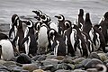
161:in Magdalena Island
159:Magellanic penguins
63:Tourist attractions
51:, the southernmost
109:free economic zone
57:American continent
89:Carretera Austral
49:Chilean Patagonia
267:
255:Tourism in Chile
234:
233:
231:
230:
220:
199:
184:
170:
155:
141:
93:Los Lagos Region
85:Chilean wildlife
81:Magdalena Island
275:
274:
270:
269:
268:
266:
265:
264:
240:
239:
238:
237:
228:
226:
222:
221:
217:
212:
205:
203:Puerto Williams
200:
191:
185:
176:
171:
162:
156:
147:
142:
133:
117:Puerto Williams
113:Navarino Island
65:
47:, which is why
39:located in the
17:
12:
11:
5:
273:
271:
263:
262:
260:Roads in Chile
257:
252:
242:
241:
236:
235:
214:
213:
211:
208:
207:
206:
201:
194:
192:
186:
179:
177:
172:
165:
163:
157:
150:
148:
143:
136:
132:
129:
64:
61:
53:natural region
15:
13:
10:
9:
6:
4:
3:
2:
272:
261:
258:
256:
253:
251:
248:
247:
245:
225:
219:
216:
209:
204:
198:
193:
189:
183:
178:
175:
169:
164:
160:
154:
149:
146:
140:
135:
130:
128:
126:
122:
118:
114:
110:
106:
102:
98:
94:
90:
86:
82:
78:
74:
70:
62:
60:
58:
54:
50:
46:
42:
38:
34:
30:
26:
22:
227:. Retrieved
218:
111:; a tour of
105:cruise ships
101:Punta Arenas
97:Aysén Region
79:sighting in
66:
37:scenic route
28:
20:
18:
188:Puerto Toro
121:Puerto Toro
244:Categories
229:2019-04-02
210:References
35:touristic
131:Gallery
77:penguin
33:Chilean
31:) is a
25:Spanish
71:, the
19:The
246::
127:.
59:.
27::
232:.
23:(
Text is available under the Creative Commons Attribution-ShareAlike License. Additional terms may apply.