29:
52:
213:
59:
522:
488:
526:
492:
84:
550:
545:
155:
51:
496:
396:
530:
387:. A marine bank in Erebus and Terror Gulf with a least depth of 20 metres (66 ft). The bank extends northeast from
28:
359:
314:
249:
341:
201:
336:
233:
197:
441:
245:
331:
503:
229:
193:
291:
284:
257:
241:
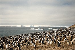
225:
33:
298:
237:
272:
399:(UK-APC) after Captain Nicholas J. Barker, RN, who was in command of the ship, 1980-82.
261:
326:
539:
125:
37:
470:
391:, James Ross Island, but its limits are not precisely defined. Charted from HMS
216:
Trinity
Peninsula on Antarctic Peninsula. Erebus and Terror Gulf to the northeast
265:
253:
221:
212:
140:
374:
361:
171:
157:
100:
86:
388:
211:
135:
429:
413:
411:
478:(2 ed.), United States Board on Geographic Names
192:) is a gulf on the southeast side of the tip of the
134:
124:
76:
21:
77:
58:
8:
18:
283:The Erebus and Terror Gulf was named for
264:form the southwest edge of the gulf. The
551:Landforms of the Joinville Island group
497:United States Board on Geographic Names
452:
417:
407:
505:Graham Land and South Shetland Islands
301:in exploring these waters in 1842–43.
508:, BAS: British Antarctic Survey, 2005
248:enters the west of the gulf, between
36:rookery at Erebus and Terror Gulf on
7:
546:Bays of the James Ross Island group
220:The Erebus and Terror Gulf lies in
196:, bordered on the northeast by the
529:from websites or documents of the
495:from websites or documents of the
430:Graham Land and South Shetland BAS
397:UK Antarctic Place-Names Committee
14:
472:Geographic Names of the Antarctic
228:, which is itself the tip of the
525: This article incorporates
520:
491: This article incorporates
486:
57:
50:
27:
531:United States Geological Survey
469:Alberts, Fred G., ed. (1995),
1:
395:, 1981-82, and named by the
200:and on the southwest by the
342:GPX (secondary coordinates)
567:
297:, the vessels used by Sir
337:GPX (primary coordinates)
312:Map all coordinates using
45:
26:
320:Download coordinates as:
202:James Ross Island group
527:public domain material
493:public domain material
234:Joinville Island group
217:
198:Joinville Island group
183:Erebus and Terror Gulf
150:Erebus and Terror Gulf
112:Erebus and Terror Gulf
65:Erebus and Terror Gulf
22:Erebus and Terror Gulf
332:GPX (all coordinates)
271:This region contains
246:Prince Gustav Channel
215:
442:pbs documentary NOVA
371: /
230:Antarctic Peninsula
224:to the east of the
194:Antarctic Peninsula
167: /
96: /
244:are to the north.
218:
375:64.017°S 57.017°W
258:James Ross Island
252:to the north and
242:Tabarin Peninsula
226:Trinity Peninsula
172:63.917°S 56.667°W
146:
145:
136:Ocean/sea sources
101:63.917°S 56.667°W
558:
524:
523:
515:
514:
513:
490:
489:
485:
484:
483:
477:
456:
450:
444:
439:
433:
427:
421:
415:
386:
385:
383:
382:
381:
380:-64.017; -57.017
376:
372:
369:
368:
367:
364:
299:James Clark Ross
273:tabular icebergs
268:is to the east.
238:Andersson Island
191:
190:
188:
187:
186:
184:
179:
178:
177:-63.917; -56.667
173:
168:
165:
164:
163:
160:
137:
120:
119:
117:
116:
115:
113:
108:
107:
106:-63.917; -56.667
102:
97:
94:
93:
92:
89:
79:
61:
60:
54:
31:
19:
566:
565:
561:
560:
559:
557:
556:
555:
536:
535:
521:
518:
511:
509:
502:
487:
481:
479:
475:
468:
464:
459:
451:
447:
440:
436:
428:
424:
416:
409:
405:
379:
377:
373:
370:
365:
362:
360:
358:
357:
355:
350:
349:
348:
347:
346:
307:
281:
210:
182:
180:
176:
174:
170:
169:
166:
161:
158:
156:
154:
153:
111:
109:
105:
103:
99:
98:
95:
90:
87:
85:
83:
82:
72:
71:
70:
69:
68:
67:
66:
62:
41:
17:
12:
11:
5:
564:
562:
554:
553:
548:
538:
537:
517:
516:
500:
465:
463:
460:
458:
457:
445:
434:
422:
420:, p. 223.
406:
404:
401:
354:
351:
345:
344:
339:
334:
329:
323:
317:
310:
309:
308:
306:
303:
280:
277:
262:Seymour Island
256:to the south.
209:
206:
144:
143:
138:
132:
131:
128:
122:
121:
80:
74:
73:
64:
63:
56:
55:
49:
48:
47:
46:
43:
42:
34:Adélie penguin
32:
24:
23:
15:
13:
10:
9:
6:
4:
3:
2:
563:
552:
549:
547:
544:
543:
541:
534:
532:
528:
507:
506:
501:
498:
494:
474:
473:
467:
466:
461:
455:, p. 45.
454:
449:
446:
443:
438:
435:
431:
426:
423:
419:
414:
412:
408:
402:
400:
398:
394:
390:
384:
352:
343:
340:
338:
335:
333:
330:
328:
325:
324:
322:
321:
316:
315:OpenStreetMap
313:
304:
302:
300:
296:
295:
289:
288:
278:
276:
274:
269:
267:
263:
259:
255:
251:
247:
243:
239:
235:
231:
227:
223:
214:
207:
205:
203:
199:
195:
189:
151:
142:
139:
133:
129:
127:
123:
118:
81:
75:
53:
44:
39:
38:Paulet Island
35:
30:
25:
20:
519:
510:, retrieved
504:
480:, retrieved
471:
453:Alberts 1995
448:
437:
425:
418:Alberts 1995
392:
356:
319:
318:
311:
293:
286:
282:
270:
250:Eagle Island
219:
149:
147:
378: /
353:Barker Bank
266:Weddell Sea
254:Vega Island
222:Graham Land
175: /
141:Weddell Sea
104: /
78:Coordinates
540:Categories
512:2024-05-03
482:2023-12-03
403:References
181: (
110: (
393:Endurance
389:Ula Point
305:Features
240:and the
208:Location
462:Sources
366:57°01′W
363:64°01′S
162:56°40′W
159:63°55′S
91:56°40′W
88:63°55′S
40:, 1996.
294:Terror
287:Erebus
232:. The
476:(PDF)
292:HMS
290:and
285:HMS
279:Name
260:and
148:The
130:Gulf
126:Type
16:Gulf
327:KML
542::
533:.
410:^
275:.
236:,
204:.
499:.
432:.
185:)
152:(
114:)
Text is available under the Creative Commons Attribution-ShareAlike License. Additional terms may apply.