50:
1165:
92:
67:
1176:
243:
99:
74:
413:
295:
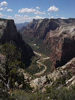
Traffic congestion in the narrow canyon was recognized as a major problem in the 1990s and a public transportation system using propane-powered shuttle buses was instituted in the year 2000. From April through
October, the scenic drive in Zion Canyon is closed to private vehicles and visitors ride
272:
The original 1916 road, built by Park
Service engineer W.O. Tufts, was a single-lane dirt road that extended as far as the Weeping Rock parking area. In 1925 a gravel-surfaced road, called the "Government Road" replaced the original road and extended all the way to the Temple of Sinawava.
1054:
1149:
1085:
1069:
1059:
1220:
1144:
1090:
1225:
731:
673:
1205:
1111:
1013:
1044:
978:
943:
1018:
923:
883:
708:
235:
Branch of Plans and
Designs to highlight the natural features of the valley while presenting a natural-appearing built environment. The road begins at the south boundary of the park and ends at the
983:
973:
968:
948:
1064:
898:
813:
933:
928:
803:
1023:
988:
893:
868:
1008:
958:
938:
913:
903:
888:
878:
863:
843:
818:
808:
798:
677:
644:
629:
504:
499:
1028:
1003:
908:
848:
828:
823:
793:
783:
963:
918:
858:
833:
788:
1095:
993:
873:
838:
269:
From the South
Entrance to Canyon Junction at the mouth of Zion Canyon the road has been reconstructed and has lost many of the characteristic features of the 1930s construction.
1215:
1049:
998:
953:
853:
761:
746:
564:
529:
1210:
701:
777:
1179:
694:
1200:
569:
131:
1169:
609:
604:
91:
468:
649:
514:
509:
741:
574:
489:
717:
477:
424:
330:
263:
36:
66:
539:
1132:
417:
49:
266:
as a particularly prominent example of the style. The road surface is coated with red aggregate to continue the design theme.
639:
461:
599:
519:
255:
179:
654:
634:
284:
1137:
1116:
659:
549:
305:
559:
454:
446:
624:
751:
258:
construction techniques according to the prevailing 1930s Park
Service policy of naturalistic design. The
231:, USA. A precursor to the present nine-mile road was first built in 1916, but was later redesigned by the
756:
736:
554:
370:
335:
232:
619:
584:
544:
481:
259:
236:
224:
359:
686:
277:
119:
383:
589:
579:
195:
1194:
360:"National Register of Historic Places Inventory-Nomination: Floor of the Valley Road"
1150:
University and college buildings listed on the
National Register of Historic Places
614:
280:
220:
432:
Floor of the Valley Road, Between Zion-Mount Carmel
Highway and Temple of Sinawa
242:
146:
133:
251:
412:
276:
In 1931 and 1932 the present road was constructed on a new alignment as a
438:
431:
1145:
List of jails and prisons on the
National Register of Historic Places
427:(HAER) documentation, filed under Springdale, Washington County, UT:
441:", 7 photos, 1 measured drawing, 1 photo caption page
674:
National
Register of Historic Places listings in Zion National Park
439:
Floor of the Valley Road, Cable Creek Bridge, Spanning Cable Creek
283:
project. Further construction was performed from 1933 to 1942 by
241:
325:
228:
1221:
National
Register of Historic Places in Washington County, Utah
690:
450:
1226:
National Register of Historic Places in Zion National Park
1206:
Roads on the National Register of Historic Places in Utah
678:
Historical buildings and structures of Zion National Park
1125:
1104:
1078:
1037:
770:
747:
History of the National Register of Historic Places
724:
528:
488:
201:
188:
178:
170:
162:
125:
115:
778:List of U.S. National Historic Landmarks by state
358:Robert Sontag and Kathy McKoy (August 15, 1995).
174:Civilian Conservation Corps; Carnes, W.G., et al.
98:
73:
1170:National Register of Historic Places portal
219:, follows the canyon of the North Fork of the
702:
462:
8:
1216:Historic American Engineering Record in Utah
434:", 13 photos, 1 photo caption page
250:The design uses local materials such as red
610:Grotto Camping Ground South Comfort Station
605:Grotto Camping Ground North Comfort Station
54:Zion Canyon and road near Observation Point
709:
695:
687:
469:
455:
447:
353:
351:
349:
347:
345:
48:
1211:Transportation in Washington County, Utah
718:U.S. National Register of Historic Places
37:U.S. National Register of Historic Places
515:Pine Creek Residential Historic District
510:Parunuweap Canyon Archeological District
317:
379:
368:
326:"National Register Information System"
20:
223:, also known as Zion Canyon, through
7:
478:National Register of Historic Places
425:Historic American Engineering Record
331:National Register of Historic Places
264:National Register of Historic Places
1201:Civilian Conservation Corps in Utah
540:Angels Landing Trail-West Rim Trail
1133:National Historic Preservation Act
399:, Green Transit - The Zion Shuttle
14:
1175:
1174:
1163:
645:South Campground Comfort Station
411:
97:
90:
72:
65:
396:
262:is separately nominated to the
1086:Federated States of Micronesia
732:Architectural style categories
565:East Entrance Checking Station
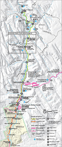
246:Map of the road in Zion Canyon
190:
1:
640:South Campground Amphitheater
106:Show map of the United States
600:Gateway to the Narrows Trail
520:Zion Lodge Historic District
18:United States historic place
655:Zion Nature Center-Zion Inn
635:Pine Creek Irrigation Canal
500:Oak Creek Historic District
285:Civilian Conservation Corps
1242:
1138:Historic Preservation Fund
1117:American Legation, Morocco
630:Oak Creek Irrigation Canal
505:Oak Creek Irrigation Canal
1158:
1079:Lists by associated state
668:
660:Zion-Mount Carmel Highway
560:Crawford Irrigation Canal
550:Cable Mountain Draw Works
306:Zion-Mount Carmel Highway
189:NRHP reference
59:
47:
43:
34:
27:
23:
1060:Northern Mariana Islands
595:Floor of the Valley Road
437:HAER No. UT-73-A, "
418:Floor of the Valley Road
365:. National Park Service.
217:Zion Canyon Scenic Drive
213:Floor of the Valley Road
29:Floor of the Valley Road
625:Museum-Grotto Residence
570:East Entrance Residence
1055:Minor Outlying Islands
1038:Lists by insular areas
752:Keeper of the Register
430:HAER No. UT-73, "
378:Cite journal requires
247:
184:Zion National Park MRA
147:37.25556°N 112.95472°W
757:National Park Service
737:Contributing property
555:Canyon Overlook Trail
420:at Wikimedia Commons
336:National Park Service
245:
233:National Park Service
1112:District of Columbia
291:Traffic restrictions
215:, also known as the
152:37.25556; -112.95472
650:South Entrance Sign
620:Hidden Canyon Trail
585:Emerald Pools Trail
296:the shuttle buses.
143: /
575:East Entrance Sign
545:Cable Creek Bridge
482:Zion National Park
260:Cable Creek Bridge
248:
237:Temple of Sinawava
225:Zion National Park
1188:
1187:
742:Historic district
684:
683:
416:Media related to
338:. April 15, 2008.
209:
208:
205:February 16, 1996
1233:
1178:
1177:
1168:
1167:
1166:
1091:Marshall Islands
711:
704:
697:
688:
471:
464:
457:
448:
415:
400:
394:
388:
387:
381:
376:
374:
366:
364:
355:
340:
339:
322:
192:
158:
157:
155:
154:
153:
148:
144:
141:
140:
139:
136:
120:Springdale, Utah
107:
101:
100:
94:
82:
81:Show map of Utah
76:
75:
69:
52:
21:
1241:
1240:
1236:
1235:
1234:
1232:
1231:
1230:
1191:
1190:
1189:
1184:
1164:
1162:
1154:
1121:
1100:
1074:
1033:
766:
720:
715:
685:
680:
664:
531:
524:
491:
484:
475:
409:
404:
403:
395:
391:
377:
367:
362:
357:
356:
343:
324:
323:
319:
314:
302:
293:
151:
149:
145:
142:
137:
134:
132:
130:
129:
111:
110:
109:
108:
105:
104:
103:
102:
85:
84:
83:
80:
79:
78:
77:
55:
39:
30:
19:
12:
11:
5:
1239:
1237:
1229:
1228:
1223:
1218:
1213:
1208:
1203:
1193:
1192:
1186:
1185:
1183:
1182:
1172:
1159:
1156:
1155:
1153:
1152:
1147:
1142:
1141:
1140:
1129:
1127:
1123:
1122:
1120:
1119:
1114:
1108:
1106:
1102:
1101:
1099:
1098:
1093:
1088:
1082:
1080:
1076:
1075:
1073:
1072:
1070:Virgin Islands
1067:
1062:
1057:
1052:
1047:
1045:American Samoa
1041:
1039:
1035:
1034:
1032:
1031:
1026:
1021:
1016:
1011:
1006:
1001:
996:
991:
986:
981:
979:South Carolina
976:
971:
966:
961:
956:
951:
946:
944:North Carolina
941:
936:
931:
926:
921:
916:
911:
906:
901:
896:
891:
886:
881:
876:
871:
866:
861:
856:
851:
846:
841:
836:
831:
826:
821:
816:
811:
806:
801:
796:
791:
786:
781:
774:
772:
771:Lists by state
768:
767:
765:
764:
762:Property types
759:
754:
749:
744:
739:
734:
728:
726:
722:
721:
716:
714:
713:
706:
699:
691:
682:
681:
669:
666:
665:
663:
662:
657:
652:
647:
642:
637:
632:
627:
622:
617:
612:
607:
602:
597:
592:
590:Flanigan Ditch
587:
582:
580:East Rim Trail
577:
572:
567:
562:
557:
552:
547:
542:
536:
534:
526:
525:
523:
522:
517:
512:
507:
502:
496:
494:
486:
485:
476:
474:
473:
466:
459:
451:
445:
444:
443:
442:
435:
408:
407:External links
405:
402:
401:
389:
380:|journal=
341:
316:
315:
313:
310:
309:
308:
301:
298:
292:
289:
278:Depression-era
207:
206:
203:
199:
198:
193:
186:
185:
182:
176:
175:
172:
168:
167:
164:
160:
159:
127:
123:
122:
117:
113:
112:
96:
95:
89:
88:
87:
86:
71:
70:
64:
63:
62:
61:
60:
57:
56:
53:
45:
44:
41:
40:
35:
32:
31:
28:
25:
24:
17:
13:
10:
9:
6:
4:
3:
2:
1238:
1227:
1224:
1222:
1219:
1217:
1214:
1212:
1209:
1207:
1204:
1202:
1199:
1198:
1196:
1181:
1173:
1171:
1161:
1160:
1157:
1151:
1148:
1146:
1143:
1139:
1136:
1135:
1134:
1131:
1130:
1128:
1124:
1118:
1115:
1113:
1110:
1109:
1107:
1103:
1097:
1094:
1092:
1089:
1087:
1084:
1083:
1081:
1077:
1071:
1068:
1066:
1063:
1061:
1058:
1056:
1053:
1051:
1048:
1046:
1043:
1042:
1040:
1036:
1030:
1027:
1025:
1022:
1020:
1019:West Virginia
1017:
1015:
1012:
1010:
1007:
1005:
1002:
1000:
997:
995:
992:
990:
987:
985:
982:
980:
977:
975:
972:
970:
967:
965:
962:
960:
957:
955:
952:
950:
947:
945:
942:
940:
937:
935:
932:
930:
927:
925:
924:New Hampshire
922:
920:
917:
915:
912:
910:
907:
905:
902:
900:
897:
895:
892:
890:
887:
885:
884:Massachusetts
882:
880:
877:
875:
872:
870:
867:
865:
862:
860:
857:
855:
852:
850:
847:
845:
842:
840:
837:
835:
832:
830:
827:
825:
822:
820:
817:
815:
812:
810:
807:
805:
802:
800:
797:
795:
792:
790:
787:
785:
782:
779:
776:
775:
773:
769:
763:
760:
758:
755:
753:
750:
748:
745:
743:
740:
738:
735:
733:
730:
729:
727:
723:
719:
712:
707:
705:
700:
698:
693:
692:
689:
679:
675:
672:
667:
661:
658:
656:
653:
651:
648:
646:
643:
641:
638:
636:
633:
631:
628:
626:
623:
621:
618:
616:
613:
611:
608:
606:
603:
601:
598:
596:
593:
591:
588:
586:
583:
581:
578:
576:
573:
571:
568:
566:
563:
561:
558:
556:
553:
551:
548:
546:
543:
541:
538:
537:
535:
533:
527:
521:
518:
516:
513:
511:
508:
506:
503:
501:
498:
497:
495:
493:
487:
483:
479:
472:
467:
465:
460:
458:
453:
452:
449:
440:
436:
433:
429:
428:
426:
423:
422:
421:
419:
414:
406:
398:
393:
390:
385:
372:
361:
354:
352:
350:
348:
346:
342:
337:
333:
332:
327:
321:
318:
311:
307:
304:
303:
299:
297:
290:
288:
286:
282:
279:
274:
270:
267:
265:
261:
257:
253:
244:
240:
238:
234:
230:
226:
222:
218:
214:
204:
202:Added to NRHP
200:
197:
194:
187:
183:
181:
177:
173:
169:
165:
161:
156:
128:
124:
121:
118:
114:
93:
68:
58:
51:
46:
42:
38:
33:
26:
22:
16:
984:South Dakota
974:Rhode Island
969:Pennsylvania
949:North Dakota
670:
615:Grotto Trail
594:
410:
392:
371:cite journal
329:
320:
294:
281:public works
275:
271:
268:
249:
221:Virgin River
216:
212:
210:
116:Nearest city
15:
1105:Other areas
1065:Puerto Rico
899:Mississippi
814:Connecticut
397:NPS website
150: /
138:112°57′17″W
126:Coordinates
1195:Categories
1014:Washington
934:New Mexico
929:New Jersey
804:California
532:properties
312:References
135:37°15′20″N
1024:Wisconsin
989:Tennessee
894:Minnesota
869:Louisiana
671:See also:
492:districts
252:sandstone
171:Architect
1180:Category
1009:Virginia
959:Oklahoma
939:New York
914:Nebraska
904:Missouri
889:Michigan
879:Maryland
864:Kentucky
844:Illinois
819:Delaware
809:Colorado
799:Arkansas
490:Historic
300:See also
196:96000048
1126:Related
1029:Wyoming
1004:Vermont
909:Montana
849:Indiana
829:Georgia
824:Florida
794:Arizona
784:Alabama
287:labor.
964:Oregon
919:Nevada
859:Kansas
834:Hawaii
789:Alaska
725:Topics
256:rustic
1096:Palau
994:Texas
874:Maine
839:Idaho
530:Other
363:(pdf)
163:Built
1050:Guam
999:Utah
954:Ohio
854:Iowa
384:help
254:and
229:Utah
211:The
166:1932
480:in
191:No.
180:MPS
1197::
676:♦
375::
373:}}
369:{{
344:^
334:.
328:.
239:.
227:,
780::
710:e
703:t
696:v
470:e
463:t
456:v
386:)
382:(
Text is available under the Creative Commons Attribution-ShareAlike License. Additional terms may apply.