44:
232:
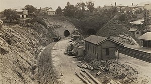
trains. The existing platforms used up all the available space between the
Stephens Road tunnel and the Gloucester Street bridge. Rather than going to the expense of rebuilding the bridge or the tunnel, and due to the proximity of Vulture Street, it closed in 1978 with the opening of the
353:
213:
Station as part of a new line replacing the one through
Woolloongabba for passenger traffic. All that is left of the station is the overgrown unused platform and three tunnel entrances leading to
482:
477:
346:
75:
43:
339:
467:
229:
202:
472:
386:
391:
411:
319:
210:
22:
441:
401:
206:
63:
436:
431:
421:
416:
376:
426:
381:
371:
214:
194:
128:
446:
396:
259:
315:
287:
234:
110:
331:
221:
461:
225:
254:
209:
stations. The station was opened on 21 December 1891 along with Park Road and
198:
282:
90:
77:
48:
Gloucester Street
Railway station ca 1930 (State Library of Queensland)
263:. No. 5, 983. Queensland, Australia. 21 December 1891. p. 5
335:
224:
were progressively lengthened in the late 1970s to accommodate
16:
Former railway station in
Brisbane, Queensland, Australia
314:. Brisbane: Australian Railway Historical Society.
168:
163:
155:
150:
142:
134:
124:
116:
106:
69:
58:
53:
30:
291:. Queensland, Australia. 4 July 1891. p. 35
347:
8:
483:Railway stations in Australia opened in 1891
478:Railway stations in Australia closed in 1978
354:
340:
332:
299:– via National Library of Australia.
271:– via National Library of Australia.
42:
27:
246:
362:Disused railway stations in Queensland
7:
468:Disused railway stations in Brisbane
310:Kerr, John; Armstrong, John (1978).
14:
191:Gloucester Street railway station
1:
283:"Melbourne-street Extension"
220:Most platforms south of the
23:Gloucester Road tube station
499:
312:Destination South Brisbane
20:
473:Highgate Hill, Queensland
367:
184:
180:
176:
41:
21:Not to be confused with
91:27.487737°S 153.02438°E
230:Electric Multiple Unit
96:-27.487737; 153.02438
201:, Australia between
255:"Railway Extension"
193:was located on the
87: /
62:Gloucester Street,
54:General information
455:
454:
407:Gloucester Street
188:
187:
34:Gloucester Street
490:
356:
349:
342:
333:
326:
325:
307:
301:
300:
298:
296:
288:The Queenslander
279:
273:
272:
270:
268:
251:
102:
101:
99:
98:
97:
92:
88:
85:
84:
83:
80:
46:
28:
498:
497:
493:
492:
491:
489:
488:
487:
458:
457:
456:
451:
363:
360:
330:
329:
322:
309:
308:
304:
294:
292:
281:
280:
276:
266:
264:
253:
252:
248:
243:
235:Merivale Bridge
120:Queensland Rail
111:Queensland Rail
95:
93:
89:
86:
81:
78:
76:
74:
73:
49:
37:
36:
35:
26:
17:
12:
11:
5:
496:
494:
486:
485:
480:
475:
470:
460:
459:
453:
452:
450:
449:
444:
439:
434:
429:
424:
419:
414:
412:Mayne Junction
409:
404:
399:
394:
389:
384:
379:
374:
368:
365:
364:
361:
359:
358:
351:
344:
336:
328:
327:
320:
302:
274:
245:
244:
242:
239:
222:Brisbane River
211:South Brisbane
203:Vulture Street
195:Cleveland line
186:
185:
182:
181:
178:
177:
174:
173:
170:
166:
165:
161:
160:
157:
156:Structure type
153:
152:
148:
147:
144:
140:
139:
136:
132:
131:
126:
122:
121:
118:
114:
113:
108:
104:
103:
71:
67:
66:
60:
56:
55:
51:
50:
47:
39:
38:
33:
32:
31:
15:
13:
10:
9:
6:
4:
3:
2:
495:
484:
481:
479:
476:
474:
471:
469:
466:
465:
463:
448:
445:
443:
440:
438:
435:
433:
430:
428:
425:
423:
420:
418:
415:
413:
410:
408:
405:
403:
400:
398:
395:
393:
392:2nd Cleveland
390:
388:
387:1st Cleveland
385:
383:
380:
378:
375:
373:
370:
369:
366:
357:
352:
350:
345:
343:
338:
337:
334:
323:
317:
313:
306:
303:
290:
289:
284:
278:
275:
262:
261:
260:The Telegraph
256:
250:
247:
240:
238:
236:
231:
227:
223:
218:
216:
212:
208:
204:
200:
196:
192:
183:
179:
175:
171:
167:
162:
158:
154:
149:
145:
141:
137:
133:
130:
127:
123:
119:
115:
112:
109:
105:
100:
72:
68:
65:
64:Highgate Hill
61:
57:
52:
45:
40:
29:
24:
19:
406:
311:
305:
295:29 September
293:. Retrieved
286:
277:
267:28 September
265:. Retrieved
258:
249:
228:and the new
219:
190:
189:
151:Construction
18:
117:Operated by
94: /
82:153°01′28″E
70:Coordinates
462:Categories
442:Whinstanes
402:Eagle Farm
321:0909937095
241:References
215:South Bank
199:Queensland
79:27°29′16″S
207:Park Road
135:Platforms
129:Cleveland
437:Tennyson
432:Pinkenba
422:Normanby
417:Meeandah
107:Owned by
59:Location
377:Barinia
226:SX sets
164:History
125:Line(s)
427:Nyanda
382:Bunour
372:Badgen
318:
169:Closed
159:Ground
143:Tracks
138:2 side
447:Yurol
397:Doboy
316:ISBN
297:2018
269:2018
205:and
172:1978
237:.
197:in
464::
285:.
257:.
217:.
355:e
348:t
341:v
324:.
146:3
25:.
Text is available under the Creative Commons Attribution-ShareAlike License. Additional terms may apply.