Name
Location
Type
Completed Date designated
Grid ref. Entry number Image
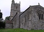
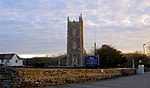
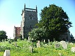
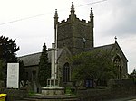
Parish Church of St Mary
Acton Turville , South Gloucestershire Parish Church
12th century
3 March 1961 ST8084480865 51°31′35″N 2°16′39″W / 51.526369°N 2.277517°W / 51.526369; -2.277517 (Parish Church of St Mary ) 1155143 Parish Church of St Mary
Archway to over Court
Over , Almondsbury, South GloucestershireGate Lodge
Mid 18th century
5 December 1984 ST5869182309 51°32′17″N 2°35′49″W / 51.538161°N 2.596997°W / 51.538161; -2.596997 (Archway to over Court ) 1321097 Upload Photo
Bishop's Farmhouse
Compton Greenfield , Almondsbury, South GloucestershireFarmhouse
Late 16th century
5 December 1984 ST5688781862 51°32′02″N 2°37′23″W / 51.534007°N 2.622951°W / 51.534007; -2.622951 (Bishop's Farmhouse ) 1128857 Upload Photo
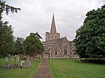
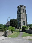
Church of All Saints
Compton Greenfield , Almondsbury, South GloucestershireParish Church
c. 1170 30 March 1960 ST5708682226 51°32′14″N 2°37′12″W / 51.537295°N 2.620127°W / 51.537295; -2.620127 (Church of All Saints ) 1321095 Church of All Saints
The Manor House
Gaunt's Earthcott, Almondsbury , South Gloucestershire
Farmhouse
16th century
21 October 1952 ST6351284200 51°33′20″N 2°31′40″W / 51.555496°N 2.527687°W / 51.555496; -2.527687 (The Manor House ) 1128866 Upload Photo
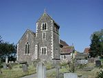
Church of St John
Aust , South GloucestershireParish Church
15th century
5 December 1984 ST5724389081 51°35′56″N 2°37′07″W / 51.598939°N 2.6187°W / 51.598939; -2.6187 (Church of St John ) 1136359 Church of St John
Church of St John
Elberton , Aust, South GloucestershireParish Church
14th century
30 March 1960 ST6023488188 51°35′28″N 2°34′32″W / 51.59113°N 2.575418°W / 51.59113; -2.575418 (Church of St John ) 1136391 Church of St John
Church of St Mary of Malmesbury
Littleton-upon-Severn , Aust, South GloucestershireParish Church
14th century
30 March 1960 ST6006890226 51°36′34″N 2°34′41″W / 51.609441°N 2.578047°W / 51.609441; -2.578047 (Church of St Mary of Malmesbury ) 1312787 Church of St Mary of Malmesbury
Corston Farmhouse
Littleton Upon Severn, Aust, South Gloucestershire
Farmhouse
Early 17th century
21 October 1952 ST5985290244 51°36′35″N 2°34′52″W / 51.609588°N 2.581168°W / 51.609588; -2.581168 (Corston Farmhouse ) 1136474 Upload Photo
Badminton House Servants Wing, adjoining and immediately to the South West of Badminton House
Badminton Park , Badminton, South GloucestershireServants' Wing
1841
10 November 1983 ST8060182858 51°32′39″N 2°16′52″W / 51.54428°N 2.28113°W / 51.54428; -2.28113 (Badminton House Servants Wing, adjoining and immediately to the South West of Badminton House ) 1129318 Upload Photo
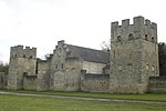
Castle Barn, flanking Dovecotes and Screen Walls
The Tyning, Badminton , South Gloucestershire
House
C20
10 November 1983 ST7928482702 51°32′34″N 2°18′00″W / 51.54283°N 2.300112°W / 51.54283; -2.300112 (Castle Barn, flanking Dovecotes and Screen Walls ) 1129344 Castle Barn, flanking Dovecotes and Screen Walls
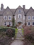
Essex House, and front Boundary Walls and Gate Piers
Badminton, South Gloucestershire
House
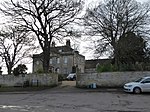
c. 1700 17 September 1952 ST8047782683 51°32′34″N 2°16′58″W / 51.542702°N 2.282908°W / 51.542702; -2.282908 (Essex House, and front Boundary Walls and Gate Piers ) 1155409 Essex House, and front Boundary Walls and Gate Piers
Hermit's Cell the Root House
Badminton Park, Badminton, South Gloucestershire
Root House
c. 1750 10 November 1983 ST8113483850 51°33′12″N 2°16′25″W / 51.553217°N 2.273498°W / 51.553217; -2.273498 (Hermit's Cell the Root House ) 1320851 Hermit's Cell the Root House
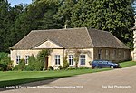
Laundry and Dairy House 30 Yards to West of Badminton House
Badminton Park, Badminton, South Gloucestershire
House
1983
10 November 1983 ST8058882945 51°32′42″N 2°16′53″W / 51.545062°N 2.281322°W / 51.545062; -2.281322 (Laundry and Dairy House 30 Yards to West of Badminton House ) 1129315 Laundry and Dairy House 30 Yards to West of Badminton House
Lower Slait Lodge
Badminton Park, Badminton, South Gloucestershire
Lodge
c. 1750 17 September 1952 ST7982083828 51°33′11″N 2°17′33″W / 51.552974°N 2.292448°W / 51.552974; -2.292448 (Lower Slait Lodge ) 1129323 Lower Slait Lodge
Orangery, 50 Yards to South East of Church of St Michael and All Angels
Badminton Park, Badminton, South Gloucestershire
Orangery
1711
17 September 1952 ST8070682807 51°32′38″N 2°16′47″W / 51.543825°N 2.279613°W / 51.543825; -2.279613 (Orangery, 50 Yards to South East of Church of St Michael and All Angels ) 1129313 Upload Photo
Pair of Cottages 20m to the West of Almshouses, Boundary Walls to Road and Gate Piers
Badminton, South Gloucestershire
Estate Cottage
Early 18th century
3 March 1961 ST8039682672 51°32′33″N 2°17′03″W / 51.5426°N 2.284076°W / 51.5426; -2.284076 (Pair of Cottages 20m to the West of Almshouses, Boundary Walls to Road and Gate Piers ) 1129329 Upload Photo
Park Keepers House and Workshop Wing to East
Badminton Park, Badminton, South Gloucestershire
Estate Cottage
c. 1750 10 November 1983 ST8042583945 51°33′15″N 2°17′01″W / 51.554047°N 2.283729°W / 51.554047; -2.283729 (Park Keepers House and Workshop Wing to East ) 1155297 Park Keepers House and Workshop Wing to East
Pond Cottage, 30m to South West of Badminton House
Badminton Park, Badminton, South Gloucestershire
House
1983
10 November 1983 ST8057182893 51°32′41″N 2°16′54″W / 51.544594°N 2.281565°W / 51.544594; -2.281565 (Pond Cottage, 30m to South West of Badminton House ) 1129316 Upload Photo
Single Storey Ranges, Barn and Covered Way enclosing Four Sides of Courtyard at Stable Court to Badminton House
Badminton Park, Badminton, South Gloucestershire
Gate
1878
10 November 1983 ST8050682835 51°32′39″N 2°16′57″W / 51.54407°N 2.282499°W / 51.54407; -2.282499 (Single Storey Ranges, Barn and Covered Way enclosing Four Sides of Courtyard at Stable Court to Badminton House ) 1320860 Upload Photo
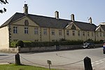
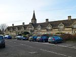
The Almshouse and former School and Boundary Walls and Gate Piers to the Road
Badminton, South Gloucestershire
Almshouses
c1707-09
3 March 1961 ST8043382678 51°32′34″N 2°17′01″W / 51.542656°N 2.283543°W / 51.542656; -2.283543 (The Almshouse and former School and Boundary Walls and Gate Piers to the Road ) 1129328 The Almshouse and former School and Boundary Walls and Gate Piers to the Road
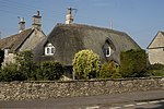
The Thatched Cottage
Badminton, South Gloucestershire
Cottage Ornee
c. 1750 10 November 1983 ST8042082320 51°32′22″N 2°17′01″W / 51.539436°N 2.28371°W / 51.539436; -2.28371 (The Thatched Cottage ) 1129341 The Thatched Cottage
Two Houses immediately to the West of the Almshouses and Boundary Walls to Road
Badminton, South Gloucestershire
Estate Cottage
Early 18th century
3 March 1961 ST8040782674 51°32′33″N 2°17′02″W / 51.542619°N 2.283917°W / 51.542619; -2.283917 (Two Houses immediately to the West of the Almshouses and Boundary Walls to Road ) 1155417 Upload Photo
Church Farmhouse
Bitton , South GloucestershireFarmhouse
Mid 19th century
15 July 1981 ST6817069411 51°25′22″N 2°27′33″W / 51.422808°N 2.459165°W / 51.422808; -2.459165 (Church Farmhouse ) 1319783 Upload Photo
Londonderry Farmhouse
Bitton, South Gloucestershire
Farmhouse
1672
11 May 1953 ST6637469878 51°25′37″N 2°29′06″W / 51.426903°N 2.485039°W / 51.426903; -2.485039 (Londonderry Farmhouse ) 1116793 Upload Photo
The Grange, Gates and Gate Piers at the South East Corner of the Grange
Bitton, South Gloucestershire
House
17th century
11 May 1953 ST6818769312 51°25′19″N 2°27′32″W / 51.421919°N 2.458912°W / 51.421919; -2.458912 (The Grange, Gates and Gate Piers at the South East Corner of the Grange ) 1116812 Upload Photo
Hamswell House
Hamswell, Cold Ashton , South Gloucestershire
Farmhouse
17th century
17 September 1952 ST7319271498 51°26′31″N 2°23′14″W / 51.441834°N 2.3871°W / 51.441834; -2.3871 (Hamswell House ) 1220723 Hamswell House
Church of St Peter
Wapley , Dodington , South GloucestershireParish Church
13th century
15 August 1985 ST7138079725 51°30′57″N 2°24′50″W / 51.515716°N 2.413839°W / 51.515716; -2.413839 (Church of St Peter ) 1211521 Church of St Peter
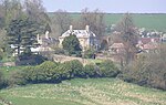
Codrington Court
Codrington , Dodington, South GloucestershireFarmhouse
16th century
17 September 1952 ST7277778536 51°30′18″N 2°23′37″W / 51.505095°N 2.393615°W / 51.505095; -2.393615 (Codrington Court ) 1220995 Upload Photo
The Cascade Building about 80m North East of Dodington House and Railings
Dodington Park , Dodington, South GloucestershireGate
1764
17 September 1952 ST7531779939 51°31′04″N 2°21′26″W / 51.517827°N 2.357119°W / 51.517827; -2.357119 (The Cascade Building about 80m North East of Dodington House and Railings ) 1211179 Upload Photo
Church of Holy Trinity
Doynton , South GloucestershireParish Church
12th century
15 August 1985 ST7205574113 51°27′55″N 2°24′13″W / 51.465291°N 2.403666°W / 51.465291; -2.403666 (Church of Holy Trinity ) 1211665 Church of Holy Trinity
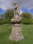
Statue of Neptune About 320m East of Dyrham House
Dyrham Park , Dyrham and Hinton , South GloucestershireStatue
between 1700 and 1712
17 September 1952 ST7444075665 51°28′46″N 2°22′10″W / 51.479359°N 2.369447°W / 51.479359; -2.369447 (Statue of Neptune About 320m East of Dyrham House ) 1212355 Statue of Neptune About 320m East of Dyrham House
Church of St Peter
Frampton Cotterell , South GloucestershireAnglican Church
1858
25 September 1985 ST6675882002 51°32′09″N 2°28′50″W / 51.535935°N 2.480661°W / 51.535935; -2.480661 (Church of St Peter ) 1136248 Church of St Peter
Blocks 1 and 2 and linking Arcade to Hanham Hall Hospital
Hanham Abbots , South GloucestershireHouse
1655
15 July 1981 ST6444071634 51°26′33″N 2°30′47″W / 51.442573°N 2.513032°W / 51.442573; -2.513032 (Blocks 1 and 2 and linking Arcade to Hanham Hall Hospital ) 1278348 Upload Photo
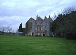
Hanham Court
Hanham Green, Hanham Abbots, South Gloucestershire
House
Late Victorian-Early C20
11 May 1953 ST6493870267 51°25′49″N 2°30′21″W / 51.430314°N 2.505731°W / 51.430314; -2.505731 (Hanham Court ) 1319770 Hanham Court
Parish Church of St George
Hanham Green, Hanham Abbots, South Gloucestershire
Church
Earlier
11 May 1953 ST6496870274 51°25′49″N 2°30′19″W / 51.430378°N 2.5053°W / 51.430378; -2.5053 (Parish Church of St George ) 1116822 Upload Photo
Tithe Barn to North of Hanham Court
Hanham Green, Hanham Abbots, South Gloucestershire
Tithe Barn
probably 15th century
11 May 1953 ST6494670306 51°25′50″N 2°30′20″W / 51.430665°N 2.50562°W / 51.430665; -2.50562 (Tithe Barn to North of Hanham Court ) 1116823 Upload Photo
Coach House, Stables and Pigsty 40m to North of Swangrove House
Swangrove, Hawkesbury , South Gloucestershire
Garage
1983
17 September 1952 ST7967985847 51°34′16″N 2°17′41″W / 51.571122°N 2.294599°W / 51.571122; -2.294599 (Coach House, Stables and Pigsty 40m to North of Swangrove House ) 1129381 Upload Photo
Dovecote
Little Badminton Green, Hawkesbury, South Gloucestershire
Dovecote
late medieval
17 September 1952 ST8009884108 51°33′20″N 2°17′18″W / 51.555501°N 2.288454°W / 51.555501; -2.288454 (Dovecote ) 1303080 Dovecote
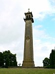
Monument to Lord Robert Edward Somerset
Hawkesbury Upton , Hawkesbury, South GloucestershireTower
1846
10 November 1983 ST7722787649 51°35′14″N 2°19′48″W / 51.58723°N 2.330095°W / 51.58723; -2.330095 (Monument to Lord Robert Edward Somerset ) 1320834 Monument to Lord Robert Edward Somerset
Ragged Castle or Keeper's Lodge
Hawkesbury, South Gloucestershire
Garden Building
c. 1750 10 November 1983 ST8050086093 51°34′24″N 2°16′58″W / 51.573363°N 2.282767°W / 51.573363; -2.282767 (Ragged Castle or Keeper's Lodge ) 1156209 Upload Photo
Church of St Michael
Hill , South GloucestershireParish Church
13th century
30 March 1960 ST6494295232 51°39′17″N 2°30′29″W / 51.654775°N 2.508169°W / 51.654775; -2.508169 (Church of St Michael ) 1136564 Church of St Michael
Mudgedown Farmhouse
Iron Acton , South GloucestershireFarmhouse
Mid 17th century
17 September 1952 ST6840585060 51°33′49″N 2°27′26″W / 51.563525°N 2.457192°W / 51.563525; -2.457192 (Mudgedown Farmhouse ) 1116018 Upload Photo
Rodway Hill Manor (East and West Wing)
Mangotsfield Rural , South GloucestershireHouse
Later
11 May 1953 ST6634675828 51°28′49″N 2°29′10″W / 51.480399°N 2.48601°W / 51.480399; -2.48601 (Rodway Hill Manor (East and West Wing) ) 1116174 Upload Photo
Barn, 25m to North of Home Farmhouse
Marshfield , South GloucestershireBarn
17th century OR EARLY 18th century
17 September 1952 ST7816273765 51°27′45″N 2°18′57″W / 51.462432°N 2.315734°W / 51.462432; -2.315734 (Barn, 25m to North of Home Farmhouse ) 1320825 Upload Photo
Crispe Almshouses and Chapel
Marshfield , South GloucestershireAlmshouse
1612-1619
17 September 1952 ST7739073771 51°27′45″N 2°19′37″W / 51.462456°N 2.326847°W / 51.462456; -2.326847 (Crispe Almshouses and Chapel ) 1302631 Crispe Almshouses and Chapel
Walls and Archway to the front of the Almshouses
Marshfield, South Gloucestershire
Wall and Gate
1612-1619
10 November 1983 ST7738973762 51°27′45″N 2°19′37″W / 51.462375°N 2.326861°W / 51.462375; -2.326861 (Walls and Archway to the front of the Almshouses ) 1320796 Walls and Archway to the front of the Almshouses
Dovecote, 5m to North-west of the Old Manor House
Marshfield, South Gloucestershire
Dovecote
C16/C17
17 September 1952 ST7815273737 51°27′44″N 2°18′57″W / 51.46218°N 2.315876°W / 51.46218; -2.315876 (Dovecote, 5m to North-west of the Old Manor House ) 1156549 Upload Photo
Marshfield House
Marshfield, South Gloucestershire
House
Late 17th century
17 September 1952 ST7809273635 51°27′41″N 2°19′00″W / 51.461261°N 2.316734°W / 51.461261; -2.316734 (Marshfield House ) 1302595 Marshfield House
The Catherine Wheel
Marshfield, South Gloucestershire
Public House
1680/1690
17 September 1952 ST7794273713 51°27′43″N 2°19′08″W / 51.461956°N 2.318898°W / 51.461956; -2.318898 (The Catherine Wheel ) 1114934 The Catherine Wheel
The Manor
Marshfield, South Gloucestershire
House
17th century
17 September 1952 ST7819773717 51°27′43″N 2°18′55″W / 51.462002°N 2.315228°W / 51.462002; -2.315228 (The Manor ) 1302923 Upload Photo
The Old Meeting House
Marshfield, South Gloucestershire
Unitarian Chapel
1752
17 September 1952 ST7777273700 51°27′43″N 2°19′17″W / 51.461833°N 2.321344°W / 51.461833; -2.321344 (The Old Meeting House ) 1157006 Upload Photo
123, High Street
Marshfield, South Gloucestershire
House
Early 18th century
17 September 1952 ST7757973726 51°27′43″N 2°19′27″W / 51.462059°N 2.324124°W / 51.462059; -2.324124 (123, High Street ) 1114944 Upload Photo
14, High Street
Marshfield, South Gloucestershire
House
Mid 18th century
17 September 1952 ST7804473735 51°27′44″N 2°19′03″W / 51.462158°N 2.317431°W / 51.462158; -2.317431 (14, High Street ) 1129418 Upload Photo
Church of St Arilda
Oldbury-on-Severn , South GloucestershireParish Church
15th century
30 March 1960 ST6083891904 51°37′28″N 2°34′02″W / 51.624582°N 2.567116°W / 51.624582; -2.567116 (Church of St Arilda ) 1128916 Church of St Arilda
Fewster's Farmhouse
Kington, Oldbury-upon-Severn, South Gloucestershire
Farmhouse
15th century
21 September 1952 ST6201190345 51°36′38″N 2°33′00″W / 51.610646°N 2.550003°W / 51.610646; -2.550003 (Fewster's Farmhouse ) 1128813 Upload Photo
Church of St Mary
Olveston , South GloucestershireParish Church
late Norman
30 March 1960 ST6007187286 51°34′59″N 2°34′40″W / 51.583008°N 2.577668°W / 51.583008; -2.577668 (Church of St Mary ) 1128929 Church of St Mary
Hill House
Olveston, South Gloucestershire
Farmhouse
Early 16th century
21 October 1952 ST5998886791 51°34′43″N 2°34′44″W / 51.578552°N 2.578809°W / 51.578552; -2.578809 (Hill House ) 1128935 Upload Photo
Olveston Court
Olveston, South Gloucestershire
Farmhouse
earlier than 19th century
21 October 1952 ST5986487054 51°34′51″N 2°34′50″W / 51.580908°N 2.580629°W / 51.580908; -2.580629 (Olveston Court ) 1128927 Upload Photo
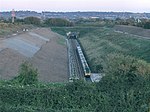
Severn Tunnel East Portal (BSW1101)
Pilning and Severn Beach , South GloucestershireRailway Tunnel Portal
1886
17 July 2012 ST5453885432 51°33′57″N 2°39′26″W / 51.565919°N 2.657277°W / 51.565919; -2.657277 (Severn Tunnel East Portal (BSW1101) ) 1409175 Severn Tunnel East Portal (BSW1101)
Dennisworth Farmhouse
Pucklechurch , South GloucestershireFarmhouse
Late 17th century
17 September 1952 ST6940576027 51°28′57″N 2°26′31″W / 51.482363°N 2.441979°W / 51.482363; -2.441979 (Dennisworth Farmhouse ) 1289567 Upload Photo
Lyde Green Farmhouse
Lyde Green, Pucklechurch, South Gloucestershire
Farmhouse
mid-late 17th century
17 September 1952 ST6845377789 51°29′53″N 2°27′21″W / 51.498153°N 2.455846°W / 51.498153; -2.455846 (Lyde Green Farmhouse ) 1289408 Upload Photo
Moat House
Pucklechurch, South Gloucestershire
Farmhouse
17th century
17 September 1952 ST6970076714 51°29′19″N 2°26′16″W / 51.488556°N 2.43779°W / 51.488556; -2.43779 (Moat House ) 1212368 Upload Photo
The Grey House
Pucklechurch, South Gloucestershire
House
1678
17 September 1952 ST6964076590 51°29′15″N 2°26′19″W / 51.487438°N 2.438643°W / 51.487438; -2.438643 (The Grey House ) 1212709 Upload Photo
Bagstone Court Farmhouse and Bakehouse 2m to South East
Bagstone, Rangeworthy , South Gloucestershire
Farmhouse
14th century
5 June 1984 ST6901386891 51°34′48″N 2°26′55″W / 51.580021°N 2.448583°W / 51.580021; -2.448583 (Bagstone Court Farmhouse and Bakehouse 2m to South East ) 1137100 Upload Photo
Church of the Holy Trinity
Rangeworthy , South GloucestershireAnglican Church
1851
30 March 1960 ST6866186248 51°34′27″N 2°27′13″W / 51.574221°N 2.453605°W / 51.574221; -2.453605 (Church of the Holy Trinity ) 1116020 Church of the Holy Trinity
Rangeworthy Court
Rangeworthy, South Gloucestershire
House
Early 17th century
21 October 1952 ST6868286277 51°34′28″N 2°27′12″W / 51.574482°N 2.453305°W / 51.574482; -2.453305 (Rangeworthy Court ) 1291208 Rangeworthy Court
Church of St Oswald
Rockhampton , South GloucestershireParish Church
14th century
30 March 1960 ST6549593294 51°38′15″N 2°30′00″W / 51.637385°N 2.499983°W / 51.637385; -2.499983 (Church of St Oswald ) 1128960 Church of St Oswald
Little Brook Farmhouse
Goose Green, Siston , South Gloucestershire
Farmhouse
late 17th century or early 18th century
3 April 1981 ST6753974324 51°28′01″N 2°28′07″W / 51.466947°N 2.468692°W / 51.466947; -2.468692 (Little Brook Farmhouse ) 1231436 Upload Photo
Lodges to Siston Court
Siston Village, Siston , South Gloucestershire
Gate Lodge
Early 19th century
11 May 1953 ST6880675385 51°28′36″N 2°27′02″W / 51.476558°N 2.450547°W / 51.476558; -2.450547 (Lodges to Siston Court ) 1231513 Lodges to Siston Court
Warmley House and Stable Block
Siston, South Gloucestershire
House
Mid 18th century
11 May 1953 ST6694672869 51°27′14″N 2°28′38″W / 51.45383°N 2.477092°W / 51.45383; -2.477092 (Warmley House and Stable Block ) 1278069 Upload Photo
Bank House
Chipping Sodbury , South GloucestershireHouse
Post World War Two
17 September 1952 ST7268682192 51°32′17″N 2°23′43″W / 51.537963°N 2.395211°W / 51.537963; -2.395211 (Bank House ) 1135952 Upload Photo
Blanchard's Farmhouse
Chipping Sodbury, South Gloucestershire
Farmhouse
15th century
29 July 1983 ST7378381756 51°32′03″N 2°22′46″W / 51.534095°N 2.379362°W / 51.534095; -2.379362 (Blanchard's Farmhouse ) 1129236 Upload Photo
Home Farmhouse
Old Sodbury , Sodbury , South GloucestershireFarmhouse
Early-mid 17th century
17 September 1952 ST7558681073 51°31′41″N 2°21′12″W / 51.528035°N 2.353321°W / 51.528035; -2.353321 (Home Farmhouse ) 1320892 Upload Photo
Lyegrove House
Lyegrove, Sodbury, South Gloucestershire
House
Early 17th century
17 September 1952 ST7764581674 51°32′01″N 2°19′25″W / 51.533524°N 2.32368°W / 51.533524; -2.32368 (Lyegrove House ) 1136069 Upload Photo
North Gateway to Dodington Park, Sites, Quadrant Walls and Chippenham Lodge and Terrace Walls
Old Sodbury, Sodbury, South Gloucestershire
Gate Lodge
Extension
17 September 1952 ST7596780931 51°31′36″N 2°20′52″W / 51.526775°N 2.34782°W / 51.526775; -2.34782 (North Gateway to Dodington Park, Sites, Quadrant Walls and Chippenham Lodge and Terrace Walls ) 1135785 Upload Photo
Parish Church of St John the Baptist
Old Sodbury, Chipping Sodbury, South Gloucestershire
Parish Church
Norman
29 July 1983 ST7555781803 51°32′05″N 2°21′14″W / 51.534597°N 2.35379°W / 51.534597; -2.35379 (Parish Church of St John the Baptist ) 1320899 Parish Church of St John the Baptist
The George Hotel
Chipping Sodbury, South Gloucestershire
Inn Sign
18th century
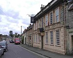
17 September 1952 ST7284382238 51°32′18″N 2°23′35″W / 51.538384°N 2.392951°W / 51.538384; -2.392951 (The George Hotel ) 1313103 The George Hotel
The Grapes Hotel
Chipping Sodbury, South Gloucestershire
Hotel
16th century
17 September 1952 ST7251382230 51°32′18″N 2°23′52″W / 51.538296°N 2.397708°W / 51.538296; -2.397708 (The Grapes Hotel ) 1320881 The Grapes Hotel
Tudor House
Sodbury, South Gloucestershire
House
Later
17 September 1952 ST7296982281 51°32′20″N 2°23′28″W / 51.538776°N 2.391138°W / 51.538776; -2.391138 (Tudor House ) 1135891 Tudor House
19 High Street
Sodbury, South Gloucestershire
House
Early 18th century
17 September 1952 ST7264182244 51°32′18″N 2°23′45″W / 51.538428°N 2.395864°W / 51.538428; -2.395864 (19 High Street ) 1129263 19 High Street
86 Broad Street
Sodbury, South Gloucestershire
House
19th century
17 September 1952 ST7292282210 51°32′17″N 2°23′31″W / 51.538136°N 2.39181°W / 51.538136; -2.39181 (86 Broad Street ) 1129254 Upload Photo
84 Broad Street
Sodbury, South Gloucestershire
House
Modern
17 September 1952 ST7291782210 51°32′17″N 2°23′31″W / 51.538136°N 2.391882°W / 51.538136; -2.391882 (84 Broad Street ) 1129253 Upload Photo
17 High Street
Sodbury, South Gloucestershire
House
early-mid 17th century
17 September 1952 ST7262682239 51°32′18″N 2°23′46″W / 51.538382°N 2.39608°W / 51.538382; -2.39608 (17 High Street ) 1135914 Upload Photo
28 High Street
Sodbury, South Gloucestershire
House
C18/C19
29 July 1983 ST7270582181 51°32′16″N 2°23′42″W / 51.537865°N 2.394936°W / 51.537865; -2.394936 (28 High Street ) 1313017 Upload Photo
1 High Street
Sodbury, South Gloucestershire
House
Late 17th century
17 September 1952 ST7257182231 51°32′18″N 2°23′49″W / 51.538308°N 2.396872°W / 51.538308; -2.396872 (1 High Street ) 1313068 1 High Street
15 High Street
Sodbury, South Gloucestershire
House
early-mid 17th century
17 September 1952 ST7262082246 51°32′18″N 2°23′46″W / 51.538445°N 2.396167°W / 51.538445; -2.396167 (15 High Street ) 1320901 15 High Street
26 High Street
Sodbury, South Gloucestershire
House
16th century
17 September 1952 ST7269482186 51°32′16″N 2°23′42″W / 51.537909°N 2.395095°W / 51.537909; -2.395095 (26 High Street ) 1320906 Upload Photo
29 Horse Street
Sodbury, South Gloucestershire
House
Mid 18th century
17 September 1952 ST7297682162 51°32′16″N 2°23′28″W / 51.537707°N 2.391028°W / 51.537707; -2.391028 (29 Horse Street ) 1129279 29 Horse Street
11 High Street
Sodbury, South Gloucestershire
House
Early 17th century
17 September 1952 ST7261382238 51°32′18″N 2°23′47″W / 51.538373°N 2.396267°W / 51.538373; -2.396267 (11 High Street ) 1313032 Upload Photo
Church of St Michael
Stoke Gifford , South GloucestershireAnglican Church
Mid 18th century
26 June 1984 ST6226179707 51°30′54″N 2°32′43″W / 51.515017°N 2.545247°W / 51.515017; -2.545247 (Church of St Michael ) 1128831 Church of St Michael
Dower House
Stoke Park , Stoke Gifford, South GloucestershireCountry House
c. 1760 26 June 1984 ST6223377251 51°29′35″N 2°32′43″W / 51.492933°N 2.545387°W / 51.492933; -2.545387 (Dower House ) 1136240 Dower House
Bristol and West Building Society
Thornbury , South GloucestershireHouse
late C18/early 19th century
21 September 1952 ST6365889969 51°36′27″N 2°31′34″W / 51.607374°N 2.52618°W / 51.607374; -2.52618 (Bristol and West Building Society ) 1136819 Upload Photo
Clematis Cottage
Thornbury, South Gloucestershire
House
16th century
21 September 1952 ST6359790307 51°36′37″N 2°31′38″W / 51.610409°N 2.527096°W / 51.610409; -2.527096 (Clematis Cottage ) 1312688 Upload Photo
Morton Grange
Upper Morton, Thornbury, South Gloucestershire
House
1594
17 December 1984 ST6493291385 51°37′13″N 2°30′29″W / 51.620187°N 2.507926°W / 51.620187; -2.507926 (Morton Grange ) 1128792 Upload Photo
Porch House
Thornbury, South Gloucestershire
House
Late 16th century
30 March 1960 ST6360990271 51°36′36″N 2°31′37″W / 51.610087°N 2.526919°W / 51.610087; -2.526919 (Porch House ) 1321130 Upload Photo
The Priory
Thornbury, South Gloucestershire
House
15th century
21 September 1952 ST6358990316 51°36′38″N 2°31′38″W / 51.61049°N 2.527213°W / 51.61049; -2.527213 (The Priory ) 1128787 Upload Photo
Old Manor House
West Littleton , Tormarton , South GloucestershireHouse
c. 1500 15 August 1985 ST7620775467 51°28′40″N 2°20′38″W / 51.477656°N 2.34399°W / 51.477656; -2.34399 (Old Manor House ) 1288609 Upload Photo
Churchyard Cross 7m North of Porch of St Leonard's Church
Tortworth , South GloucestershireCross
14th century
5 June 1984 ST7043393353 51°38′18″N 2°25′43″W / 51.638198°N 2.428638°W / 51.638198; -2.428638 (Churchyard Cross 7m North of Porch of St Leonard's Church ) 1115014 Upload Photo
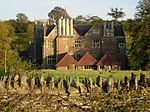
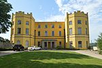
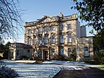
Leyhill Officers' Training School
Tortworth Park, Tortworth, South Gloucestershire
Country House
1849-1853
5 June 1984 ST6933192514 51°37′50″N 2°26′40″W / 51.630595°N 2.444488°W / 51.630595; -2.444488 (Leyhill Officers' Training School ) 1136903 Leyhill Officers' Training School
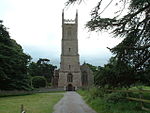
Parish Church of St Leonard
Tortworth, South Gloucestershire
Anglican Church
1872
5 June 1984 ST7043293335 51°38′17″N 2°25′43″W / 51.638036°N 2.428651°W / 51.638036; -2.428651 (Parish Church of St Leonard ) 1115013 Parish Church of St Leonard
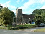
Church of St James
Tytherington , South GloucestershireAnglican Church
1884
25 September 1985 ST6685688374 51°35′36″N 2°28′47″W / 51.593232°N 2.479851°W / 51.593232; -2.479851 (Church of St James ) 1321032 Church of St James
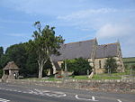
Church of St Saviour
Coalpit Heath , Westerleigh, South GloucestershireParish Church
1844-5
18 November 1981 ST6737280760 51°31′29″N 2°28′18″W / 51.524804°N 2.471693°W / 51.524804; -2.471693 (Church of St Saviour ) 1288167 Church of St Saviour
Lychgate and attached Walls about 30m East of Church of St Saviour
Coalpit Heath , Westerleigh, South GloucestershireLych Gate
1844-5
18 November 1981 ST6738180709 51°31′28″N 2°28′18″W / 51.524346°N 2.471559°W / 51.524346; -2.471559 (Lychgate and attached Walls about 30m East of Church of St Saviour ) 1288247 Lychgate and attached Walls about 30m East of Church of St Saviour
Old Vicarage
Coalpit Heath , Westerleigh , South GloucestershireHouse
1900
18 November 1981 ST6728580738 51°31′29″N 2°28′23″W / 51.524601°N 2.472945°W / 51.524601; -2.472945 (Old Vicarage ) 1288128 Upload Photo
Church of St Bartholomew
Wick and Abson , South GloucestershireParish Church
1845
15 August 1985 ST6963472754 51°27′11″N 2°26′18″W / 51.452947°N 2.438399°W / 51.452947; -2.438399 (Church of St Bartholomew ) 1216152 Church of St Bartholomew
Coachhouse and Stables 15m to North East of Oxwick Farmhouse
Wickwar , South GloucestershireTack Room
1722
17 September 1952 ST7220685947 51°34′18″N 2°24′09″W / 51.571701°N 2.40243°W / 51.571701; -2.40243 (Coachhouse and Stables 15m to North East of Oxwick Farmhouse ) 1312305 Upload Photo
Frith Farmhouse and Bakehouse at South East
Wickwar, South Gloucestershire
Farmhouse
17th century
17 September 1952 ST7178287361 51°35′04″N 2°24′31″W / 51.584393°N 2.408661°W / 51.584393; -2.408661 (Frith Farmhouse and Bakehouse at South East ) 1128768 Frith Farmhouse and Bakehouse at South East
Oxwick Farmhouse
Wickwar, South Gloucestershire
Farmhouse
1722
17 September 1952 ST7218885905 51°34′17″N 2°24′10″W / 51.571322°N 2.402686°W / 51.571322; -2.402686 (Oxwick Farmhouse ) 1321124 Oxwick Farmhouse
Parish Church of the Holy Trinity
Wickwar, South Gloucestershire
Anglican Church
c. 1881 3 March 1961 ST7234888921 51°35′54″N 2°24′02″W / 51.598447°N 2.400616°W / 51.598447; -2.400616 (Parish Church of the Holy Trinity ) 1137110 Parish Church of the Holy Trinity
Court Farm Barn
Winterbourne , South GloucestershireBarn
16th century or earlier
12 February 1979 ST6411680931 51°31′34″N 2°31′07″W / 51.526143°N 2.518641°W / 51.526143; -2.518641 (Court Farm Barn ) 1128852 Upload Photo
Faber's Farmhouse
Hambrook , Winterbourne, South GloucestershireFarmhouse
Late Medieval
17 September 1952 ST6383378859 51°30′27″N 2°31′21″W / 51.507496°N 2.522507°W / 51.507496; -2.522507 (Faber's Farmhouse ) 1276726 Upload Photo
Frenchay Manor
Frenchay , Winterbourne, South GloucestershireHouse
1736
17 September 1952 ST6412478108 51°30′03″N 2°31′06″W / 51.500762°N 2.518237°W / 51.500762; -2.518237 (Frenchay Manor ) 1128838 Frenchay Manor
Moorend Farmhouse
Moorend, Winterbourne, South Gloucestershire
Farmhouse
1676
17 September 1952 ST6510878994 51°30′32″N 2°30′15″W / 51.50879°N 2.50415°W / 51.50879; -2.50415 (Moorend Farmhouse ) 1276739 Upload Photo
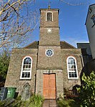
Unitarian Chapel
Frenchay, Winterbourne, South Gloucestershire
Unitarian Chapel
1720
3 March 1961 ST6397277592 51°29′46″N 2°31′13″W / 51.496113°N 2.520374°W / 51.496113; -2.520374 (Unitarian Chapel ) 1233019 Unitarian Chapel
Church of St James
Mangotsfield , South GloucestershireParish Church
13th century
24 April 1951 ST6644876177 51°29′01″N 2°29′04″W / 51.483543°N 2.484574°W / 51.483543; -2.484574 (Church of St James ) 1116192 Church of St James
Hill House
Mangotsfield, South Gloucestershire
House
c. 1700 24 April 1951 ST6570576050 51°28′56″N 2°29′43″W / 51.482357°N 2.495261°W / 51.482357; -2.495261 (Hill House ) 1320081 Upload Photo
Parish Church of the Holy Trinity and Churchyard Walls Fronting Street and on West, Running Southwards for Approximately 100 Yards
Kingswood , South GloucestershireChurch
1821
6 June 1951 ST6509473800 51°27′44″N 2°30′14″W / 51.462089°N 2.503837°W / 51.462089; -2.503837 (Parish Church of the Holy Trinity and Churchyard Walls Fronting Street and on West, Running Southwards for Approximately 100 Yards ) 1319749 Parish Church of the Holy Trinity and Churchyard Walls Fronting Street and on West, Running Southwards for Approximately 100 Yards